MAG5035
-
Posts
5,882 -
Joined
-
Last visited
Content Type
Profiles
Blogs
Forums
American Weather
Media Demo
Store
Gallery
Everything posted by MAG5035
-
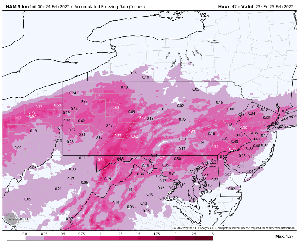
Have to acknowledge the winter threat coming up on Wednesday, I know I haven’t been posting as much lately. The key thing I see for this is simply where the best QPF and rates set up. It’s as simple as that really, given good agreement on progged low track to the south of PA and sufficient cold for a snow column. We go through this Every. Single. March/late season. If the rates are there, the snow is going to pile up on more than the mulch.. and that includes roadways and everything else in between except maybe @canderson’s property lol. With that said, having chilly but somewhat marginal surface temps and the higher March solar insolation… an event with light rates (and/or the fringe areas within the precip shield) is probably going to have some trouble accumulating on a lot of surfaces outside of higher elevations. Most guidance and ensembles are showing decent rates/amounts over a good part of our subforum. The NAM seems to be the least on board for a widespread heavier event in C-PA actually having the axis of heaviest QPF running the northern half Mid-Atlantic forum’s turf and also our southern tier. 12z was pretty nice, however the new 18z has the same axis but tightened up the good QPF. It seems like the biggest amounts in play for this event is probably going to reside in the 3-6” range. Again, rates are important.. especially with this being progged to be generally a daytime event.
-
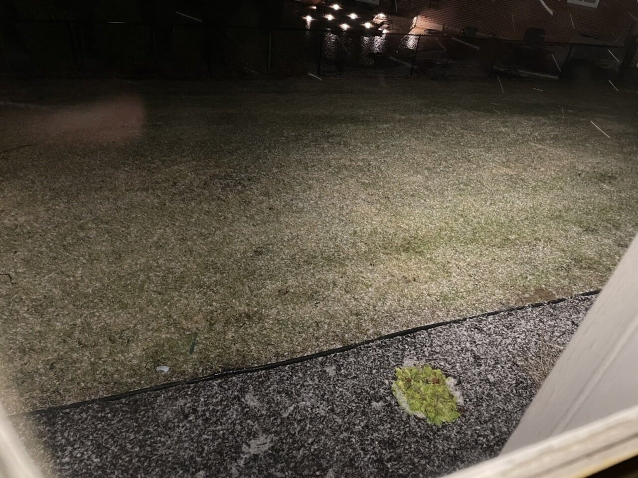
Not to snow on everyone’s Spring/Sixers parade haha, but I do have a changeover and some snow to report this early morning (dusting). 511 cams just up the hill from me in Cambria look to have gotten an inch or so.

-
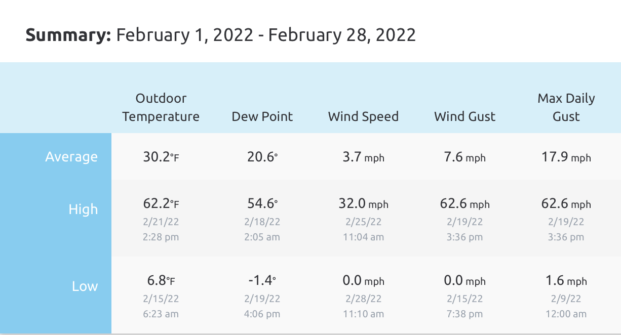
February was the first full month for my weather station so here were the basics for the month. The 30.2ºF mean looked pretty close to average compared to the local climo (KAOO) despite a handful of days that did spike up into the 50s and a couple 60+ days.

-
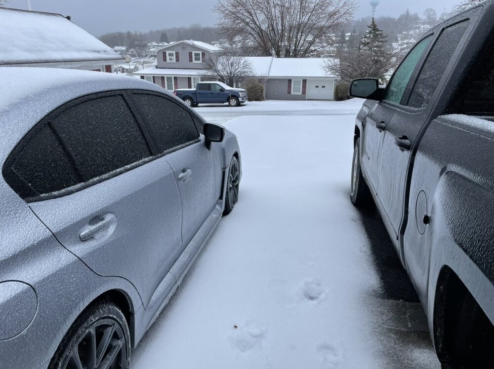
Well the reason for less freezing rain in this general area and at least the eastern Laurels was because most of the precip fell as sleet. Surface temps weren’t super cold, but that 925-900mb layer definitely was.. and it held fast for the most of the heavier precip in a pretty big chunk of the central. The main warm advection push aloft during the bulk of the event came higher in the column from about 850-700mb level. There’s no input from terrain or CAD that high up to delay or mitigate a strong WAA push, so that can often overachieve… hence why it mixed all the way into NY and north central PA didn’t see much actual snow at all. 830am this morning I measured 1.5” of sleet this morning and what I could guesstimate was about a tenth or so of ice… which has all melted off the trees this morning. Most of the sleet accum will definitely remain on the non-paved surfaces, but roads are in good shape now. It was real mess to clean up, I had to use the snowblower to remove it. But considering I’m in one of the 4 counties under a wind advisory this afternoon, I’m glad freezing rain issues weren’t huge. Extra bonus.. that 1.5” of sleet is technically the biggest snowfall I’ve had this month lol.
-
Pouring sleet right now, probably about an 80/20 blend IP vs ZR. Approx 1.2” of sleet accumulation. 31ºF/30ºF
-
Close to an inch of sleet on the ground. Think we’re starting to transition towards the ZR phase but precip is still about a 50/50 blend of sleet and freezing rain. The sleet on the ground is starting to firm up with more ZR in the mix but so far accrual is still in the glaze category and not really measurable yet. 30.7ºF/28.1ºF temp and dewpoint. Winds are up a bit, gusting past 15mph at times and mostly southerly.
-
RIght at a half inch of sleet now. Still mostly sleet and it’s pretty heavy at the moment with some large pellets. The street was actually plowed about an hour ago and the sleet’s been building back up on it. Temp up a bit to 28ºF after bottoming out around 27ºF around 11pm.
-
You’ll have to see what the p-types are when that heavier stuff on your doorstep coming at you from the southern tier gets there.
-
An hour into sleet bomb 2022. Hey it can keep doing this over having a half inch of freezing rain.
-
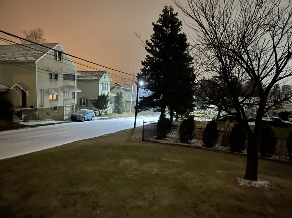
Precip arrived just before 10. As expected, full blown pingers so far… with a tad of ZR in there enough to have a glaze on most non-treated surfaces. Already getting on the roads despite the road crews being on the scene. 27.5ºF.
-
Currently 28ºF/21ºF. It’s looking like this event will be rolling by about 10pm here.. gonna be a mess.
-
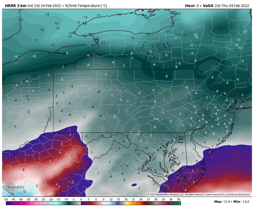
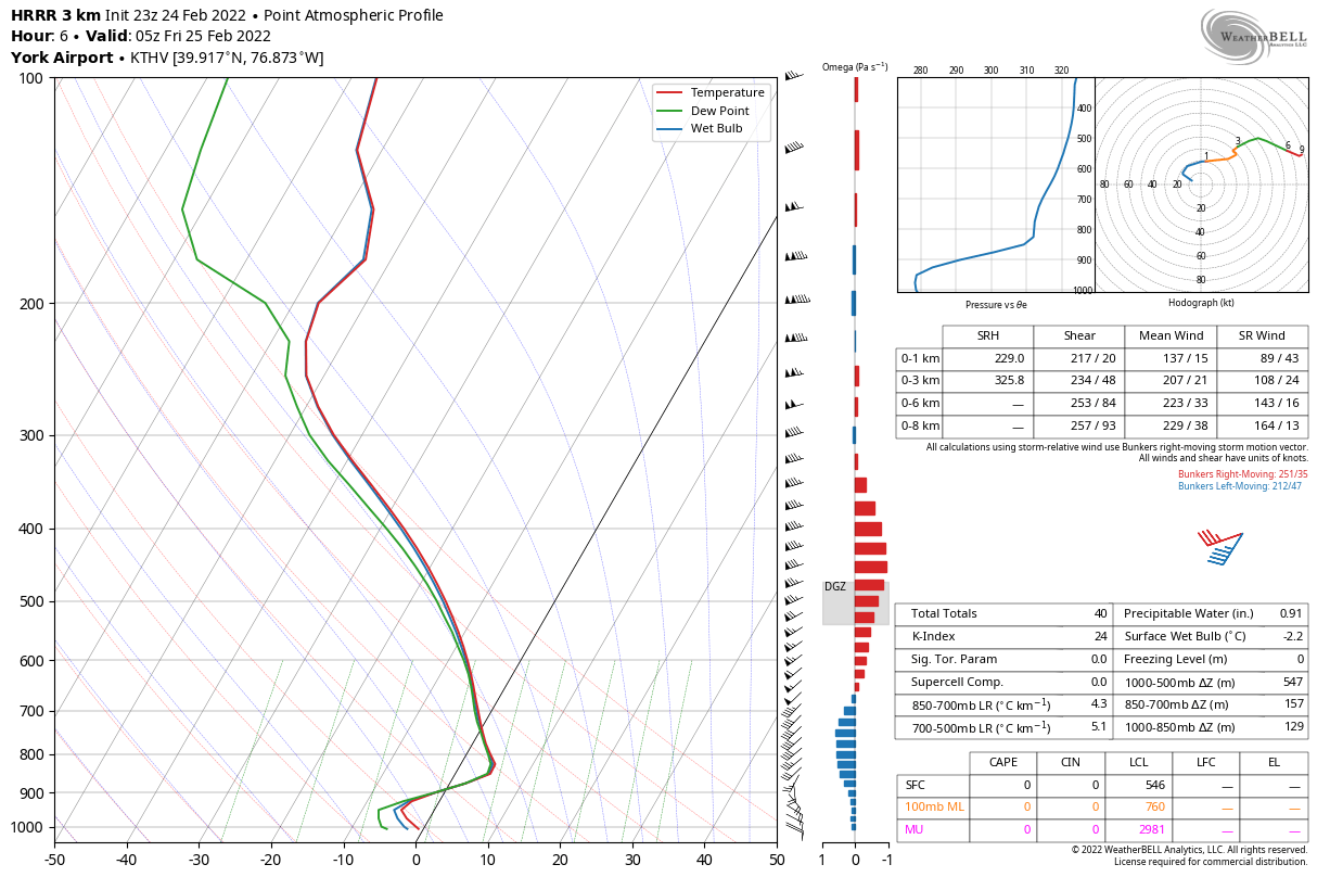
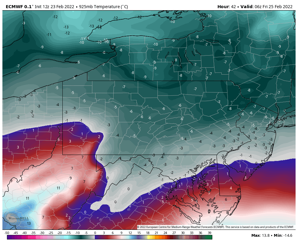
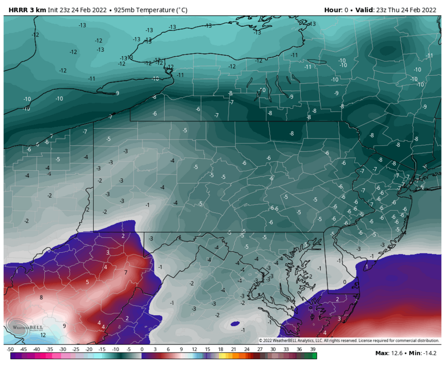
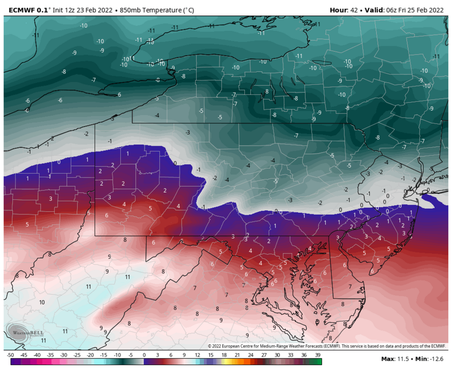
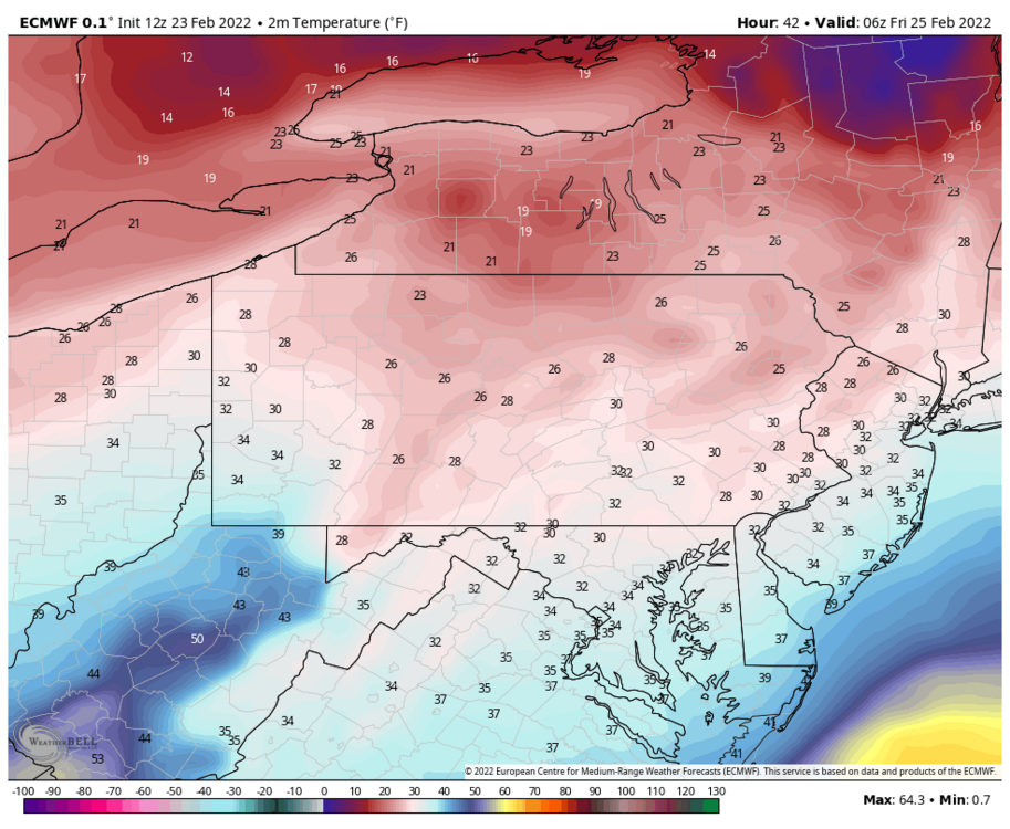
I wouldn’t write off issues completely. Yea surface temps got a tad freezing today, they were supposed to. They should fall below freezing when precip arrives. Here’s what the 23z HRRR just initialized 925mb (3000 ft) temps at. They’re about 1 degree or so warmer at precip arrival around 4-5z. But yea -6 to -5ºC is about 21-23ºF. Pretty decent depth and strength of the low level cold, so that depth suggests to me sleet’s definitely in the equation the first couple hours all the way to the mason-dixon despite what p-type maps show. Here’s THV’s sounding generated from the HRRR at 05z (approximate precip arrival). The warm nose is elevated but easily notable, but the column is below freezing from 900mb (approx 4k feet) on down to the surface. Otherwise I think CTP’s forecast/headlines are fine, though I probably would’ve considered a few more central/south like Centre, Huntingdon, Fulton, Franklin, for maybe a bit more freezing rain and less sleet. If 925-850 air advects in warmer/faster that could mean the I-80 counties also get 0.25”+ ice in exchange for a bit less sleet/snow. That’s definitely a distinct possibility as well. I do think as noted by a few in here that QPF might be a thing in the LSV as noted on the newer NAM runs. If that’s the case, that’s probably a bigger limiting factor in higher ice totals than temps IMO. This isn’t Feb 3-4, the CAD is already locked in for most of the night with the precip attacking it.

-
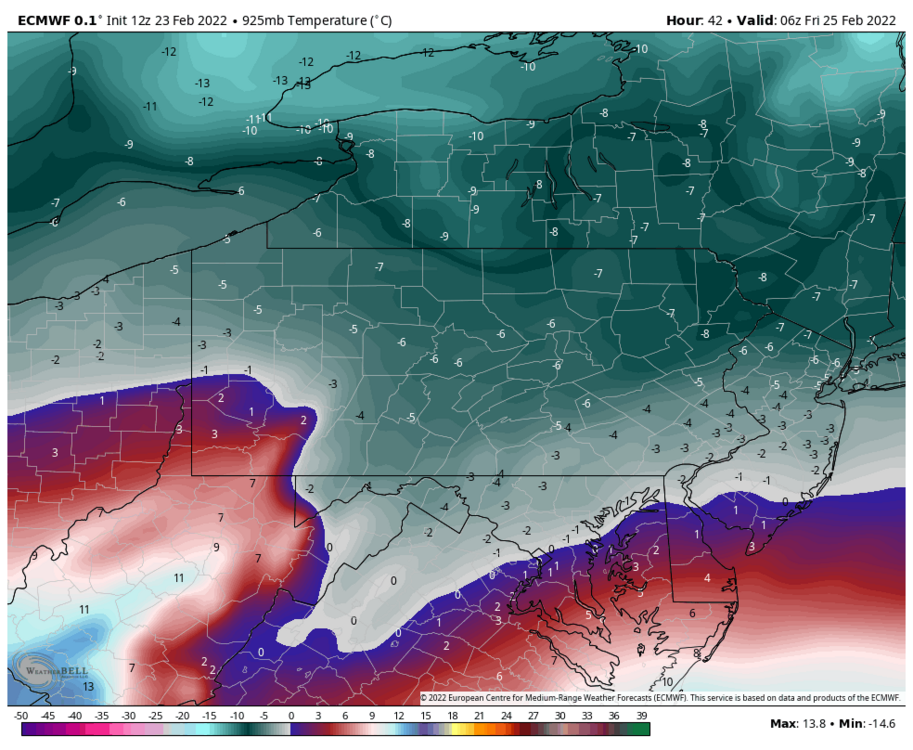
I just saw what the 18z Euro had and quite honestly it’s absurd what it’s p-type conditional has vs looking at it’s column temps. I made a post about that with the 12z run and I think 18z run is even colder. It’s even colder than the NAM aloft with all the NAM’s sleet. So the Euro is printing out all that freezing rain in southern PA while at the same time having BOTH 925mb AND 850mb temps below zero in the entire LSV except near the Mason-Dixon Line at HR 36 and 39, which are significant precip frames. One thing or the other might be wrong, but if there is that cold of a column I can guarantee freezing rain isn’t going to be the dominant p-type during that portion of the storm.
-
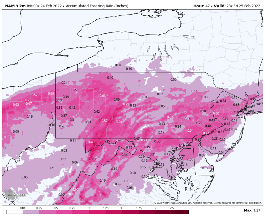
I think the 3k NAM’s ice map might be about the most reasonable ZR map I’ve seen all day. Since the NAM seems to be the one seeing the sleet the most, it makes sense that it paints the ridges in 0.25”+ while having less ice in the valleys, simply because that extra 1000-1500’ to fall and refreeze into anchored down CAD at the surface. I know it seems like I’m conducting the watch/warning train in here but I’m also not expecting a widespread excessive damaging ice event either given the depth of the CAD that should be present (more sleet). My point was just that a good portion of C-PA has more than a reasonable chance of seeing 0.25”+, hence maybe issuing a watch product when there was still 24-36hrs prior to event start. I think the only part of central PA that actually does see something more excessive on the order of >0.5”+ is the Laurel’s. It’s going to be a rough go up there.
-
Yea I don’t know it’s whatever I guess…like I mentioned this morning I don’t know why you don’t put a blanket watch out for at least a big chunk of the CWA and go warning/advisory as needed when you see where the sig ice swath is looking to set up in the near term. It better warns the public IMO. Most non-weenies aren’t going to read the HWO haha. It was even mentioned in the discussion this morning about issuing watches/warnings even if it’s just short of criteria due to the impact on roads. I mean the model support for warning criteria as well as WPC probs has been there for at least issuing a watch for the potential over a good bit more of the area than they have. At any rate we’re less than 24hrs from this starting and It’s likely to at least be a higher impact advisory event for most. 1-2”+ of sleet followed by 0.1-0.2” of ice isn’t gonna be much better on the roads than up to an inch of sleet and 0.2-0.4”+ of ice.
-
I do remember reading that previous post and I didn’t really read it as him suggesting winter was over in that post. I’ll have to find it again at some point. I mean it is a fair take now that we’ll be entering March in 5 days, especially in the LSV. But aside from trying to hash out what the MJO is going to do, I see the EPO/WPO forecast to take another dive second week of March and now the NAO/AO being forecast to at least neutralize in that timeframe as well. Yea there’s going to be more spring fling to be had the next couple weeks and AC’s cranking and @candersonis going to be doing more planting and garden prep haha… but you get those teleconnections lined up and start getting shortened wavelengths with the seasonal transition in the right spot and suddenly you might be talking about maybe not another wintry mess, but a clean snowstorm. March is going to March, aka be unpredictable. Enjoy it haha, that colds coming fast. It’s down to 35ºF here.
-
Is he talking about final for the month of February though? Sun/Mon is still in February and that potential event seems to be by the wayside. There’s some conflicting signals, but given what I see overall teleconnection wise the next couple weeks there’s no way in heck I’d just call winter off after Friday.
-
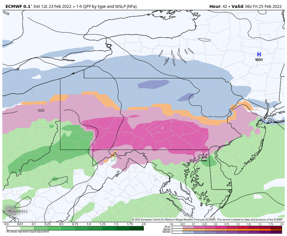
It’s scrutinizing time. Here’s the Euro at 42 hours. 1 hr ptype 2m temps 925mb (3000ft) temps 850mb What part of all that would make one think such a widespread area of freezing rain in southern PA? The -3 to -6ºC 925mb temps alone easily suggest to me sleetbomb and the 850 level isn’t even evacuated out Harrisburg and north at that point. The p-type map is really suspect to me if those low level temps in fact end up that cold.
-
The timing of this event being mostly Thur evening into Fri morning favors freezing rain accrual with say 30-31 temps, esp if it starts as and/or mixes with sleet. If this were primarily coming through during the day we are getting within that time of the year where solar would have an impact on such things.
-
I generally agree for main roads if freezing rain is the main mix p-type, but if it starts as a sleet bomb there will definitely be roadway issues… which I don’t think that map product even considers. That map is generated off of whatever CTP and other forecast CWA’s have input into their grid forecasts and those impacts are calculated off of certain criteria (ice, snow, blowing snow, flash freeze, ground blizzard, snow load), which can be separated out on the WPC site. You can see the difference between grids for CTP and PIT.
-
Oh yea, gotta have cold air if we’re going to get a wintry mess tomorrow eve haha. Pretty wide ranging temps across PA currently.
-
Temps have started to steadily fall off since about 7am this morning, going from 57ºF to currently 42ºF. It cracked 60ºF for a while just after midnight last night, just your usual 35 degree above average Feb night. 0.44” was the measured rain total from yesterday.
-
To me this is like the last time when it comes to headlines. Consideration of watch/warnings for sub criteria is specifically stated in that AFD considering the combo impact of accumulating snow/sleet and freezing rain. As it should be, so why not just issue the watch? There definitely is model support for the “potential” of warning level ice over a decent portion of C-PA. Personally for starters I think watches should match up with the ones BGM issued across the state I-80 north and tie in to the Laurels counties plus a few more central counties. Could argue just issuing the whole CWA under one if they’re going the impact over criteria route. The Sus Valley is going to get decent sleet/freezing rain up front too. The northern tier probably has the toughest case for a watch. Some of those counties require 0.5” of ZR for a warning, which probably isn’t happening up there and it’s likely going to mix too much to get near warning criteria snow in most spots. Just a lot of different scenarios to consider and pretty much all of them in this setup are pretty high impact regardless of thresholds so I just have the opinion of issue the watch and transition to advisory as needed. I think it alerts the general public better that way. I see this storm playing out one of two ways. One is you have more frozen (likely mostly sleet), which 1-2” or so (or even just an inch) of that is a high impact event in itself when it comes to roadways. That changes to freezing rain and a glaze of ice, which could still approach warning criteria in some areas anyways. That’s a pretty high impact event. Or two, deeper warmth aloft floods in (a theme this winter) and you have some sleet and a boat load of freezing rain over a pretty widespread part of C-PA. Also a high impact event. And this potential is much more viable than the Feb 3/4 event was. We’re not racing against time with bleeding cold into an ongoing rainstorm. That will be in place tonight. Placement and strength of the high pressure is very good for CAD and as I mentioned last night it doesn’t get moved out of the way. This has a pretty traditional drawn out ice storm look. And no I don’t like either of those scenarios. Southern stream waves are at a premium this winter, and here we are wasting a bunch of QPF again. With the snow aspect, I’ll be honest.. I think CTP’s current map is too optimistic. Models have generally locked into tracking the primary low into PA. So 4-6” probably stays above US 6 (maybe even out of PA completely) and the rest of the accum area is 1-3”. I think sleet is going to have a bigger role than snow when if comes to frozen. Just too much warmth aloft. Getting some snow out of this event heavily depends on if we generate WAA precip earlier tomorrow. The NAM had been the most aggressive with that, but the 12z looks like the other models, waiting until about 0z tomorrow and keeping initial precip mostly south of the M/D.
-
I think the models are starting to respond to the high pressure that will be in place to our north in terms of CAD. No change to my opinion I made a couple days ago that I thought this was the best setup in terms of high placement we’ve seen this winter. You can see on all models that the high moves a bit but generally stays in place in southern Quebec during the passage of this system. It doesn’t get shoved east out of the way. What would be really nice is just a little bit more resistance from that high to force the low under PA. Then I think we all could be in business for more front end WAA snow. As I see it currently, I think everyone sees at least advisory level ice/mix and not just a T either. The opening blast of WAA precip probably comes in as sleet or snow (dependent on intensity and timing). Then comes trying to hash out the different corridors of p-type. I-80 north stands the best chance of seeing several inches of snow/sleet and some ice but potentially having a more frozen event. The central counties below I-80 in the ridge and valley region (including the Laurels) stand the best chance of seeing warning level freezing rain and/or a stripe of more significant sleet somewhere in there. If this continues to tend colder it could shift the significant freezing rain down into the Laurel’s and southern tier ridge and valley with more frozen precip in the rest of that particular region. The Sus Valley probably sees a combo of everything (even snow) but doesn’t add up to warning criteria. It is possible though, especially H-burg north. That’s my current best take on this.
-
The only thing I’m wondering about in your neck of the woods is when CTP issues the watches and what combo of impacts is going to make up that watch lol. The 12z Euro just gave IPT 4.3” of snow prior to changeover to ice.