MAG5035
-
Posts
6,078 -
Joined
-
Last visited
Content Type
Profiles
Blogs
Forums
American Weather
Media Demo
Store
Gallery
Everything posted by MAG5035
-
The Ides of March end of Winter 2023
MAG5035 replied to paweather's topic in Upstate New York/Pennsylvania
Finally some respectable rates after all day to get something on the ground. Crushed lol
-
The Ides of March end of Winter 2023
MAG5035 replied to paweather's topic in Upstate New York/Pennsylvania
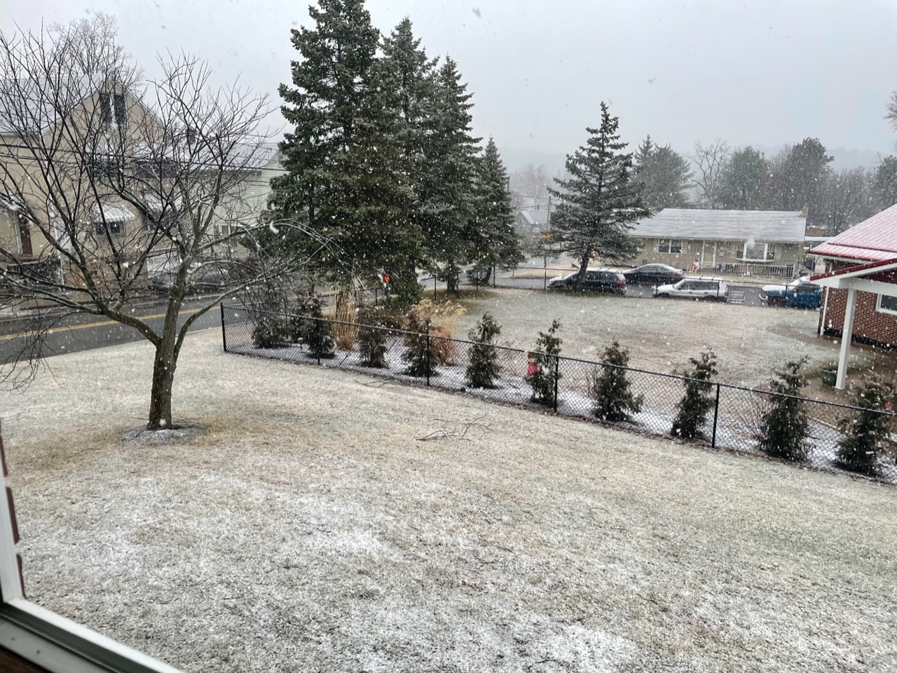
Patchy light snow here, temp has been a steady 33-34ºF. Have a light coating on some parts of the yard and mulch but nothing really measurable. The front end of this system has been a mess from the get go, which really hurt the LSV’s chance at seeing measurable with this, since there were flakes in most areas this morning. I’ll be surprised if CTP hangs on to the advisories south of I-80 with their afternoon updates but upstream PBZ radar is looking the best it has for the whole event, with a more solid area of precip associated with the weak surface low itself. So looks fairly probable central counties will get a period of steady precip early this evening with elevation variable snow totals. -
The Ides of March end of Winter 2023
MAG5035 replied to paweather's topic in Upstate New York/Pennsylvania
Looking over column thermals on the models at 850 and 925mb, there’s really good consensus on a snow column for pretty much anywhere in here for most/all of this Friday/Fri Night event. 850s stay well below zero anywhere in PA other than far SW PA and 925mb 0 line touches the PA/MD line briefly on some guidance. 700mb temps cool below -10ºC as the event evolves and the 700mb low tracks over PA, which could aid in ratios in the snow growth department. I know there’s obviously been very little to show in the LSV but the last 2-3 events have featured a colder than advertised column on onset that has allowed it to put some snow to the ground in parts of the Sus Valley that it wasn’t really in the forecast prior. This has a much better setup. Even though dying primary tracks thru PA, forced secondary development well southeast and flat trajectory of the primary ensure warm advection aloft likely won’t be a big issue and 850s hold below zero. Basically I think everyone will see snow falling, but I see a few potential issues as limiting accum factors. They’re somewhat tied together but surface temps, rates, and overall QPF. Models can print out mid 30s in the LSV at the surface or whatever and depending on timing they might be there before the event starts but if snow comes in at good enough rates you’re coming down to near or below freezing regardless, which will allow accums. I think the initial WAA stuff that comes in will be sufficient in that department, though there’s likely to be at least some elevational component. The other thing is QPF, that’s where the low track comes into play in this setup. I don’t think this dislodges the snow supporting snow column, but NW-SE primary track thru PA as it transfers to VA Beach/northern OBX will put the best QPF just to the north/northeast of the low track. Right now it would seem northern half or so of PA in best position for the highest QPF and the LSV/southern tier could be in a bit of a weak spot after the initial WAA precip. But that’s dependent on ultimate track and transfer timing. It seems like there will be some precip shield lingering overnight Friday somewhere in PA, where lighter rates will have an easier time accumulating. Could be another brief flare up of heavier precip (snow) in eastern PA as the coastal gets going well offshore as well, like the 12z Euro really suggested. That could help the Lanco folks. -
The Ides of March end of Winter 2023
MAG5035 replied to paweather's topic in Upstate New York/Pennsylvania
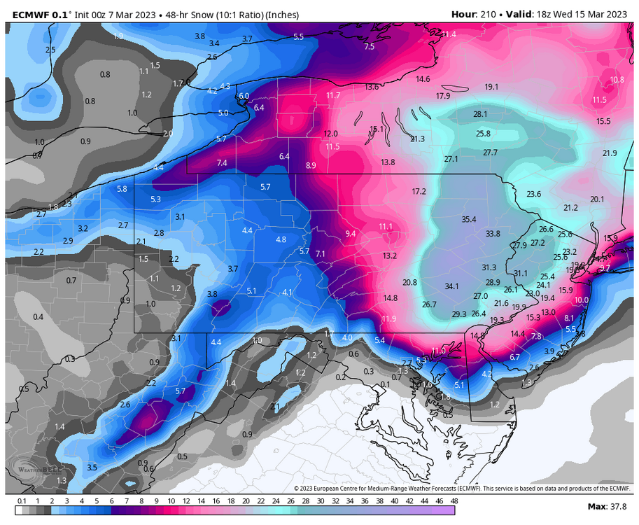
I’m not typically the snowmap poster on things past D5 or so but the 0z Euro was fun. Event #1 Fri night into Sat Event #2 the following Tues/Wed Just a complete coastal detonation in eastern PA on this second system. I’ll actually buy that solution if @Voyagerhappens to be visiting Tamaqua next week.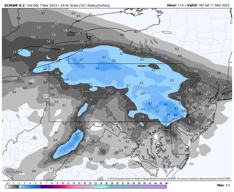
-
The Ides of March end of Winter 2023
MAG5035 replied to paweather's topic in Upstate New York/Pennsylvania
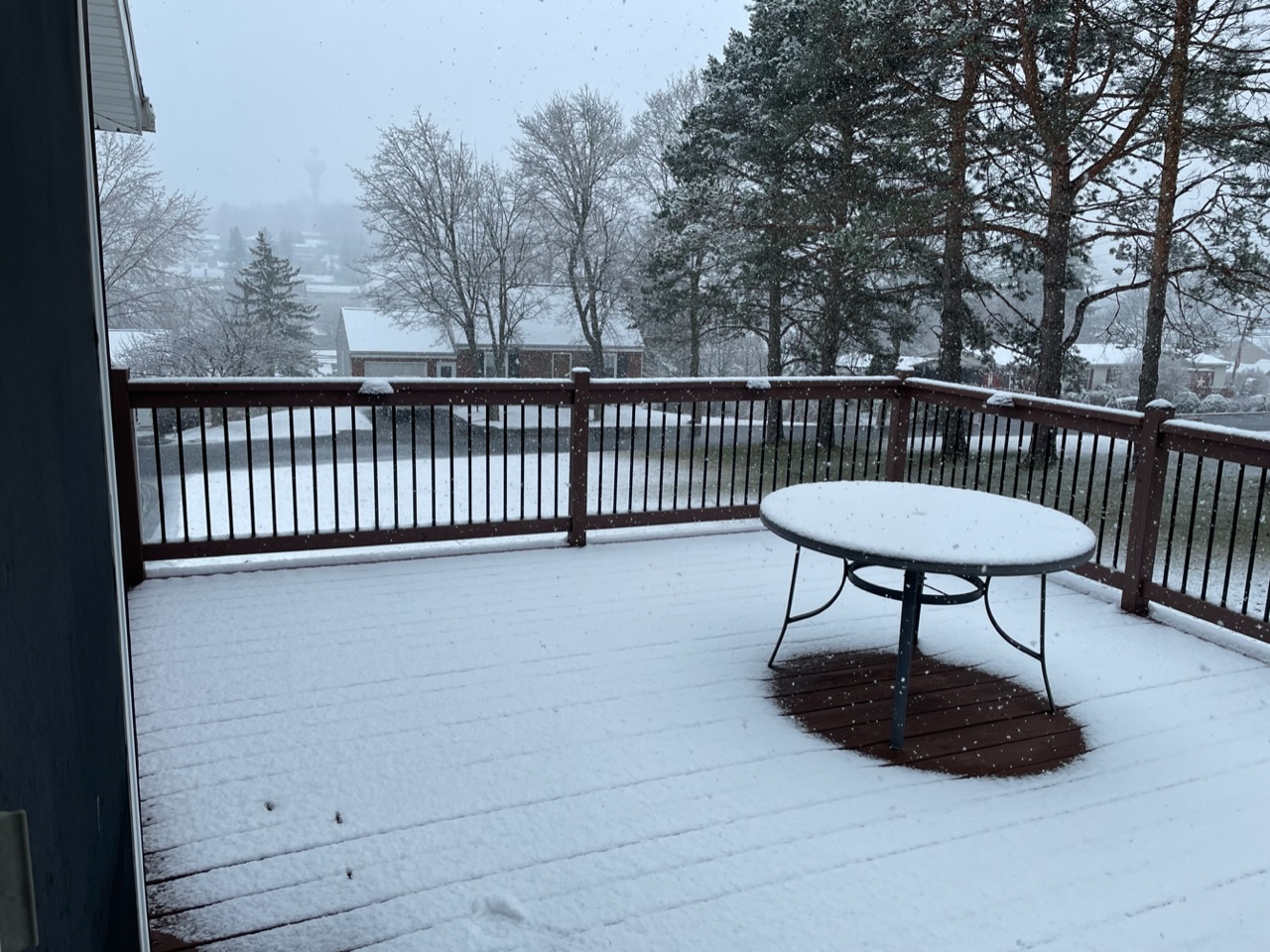
33ºF and moderate to heavy snow falling currently with a brisk NNE breeze, a rare combo in this winter. Precip arrival a couple hours ago didn’t mess around p-type wise and this has actually been mainly snow here. Accums starting in the grass and deck, too bad the back edge is coming. -
The Ides of March end of Winter 2023
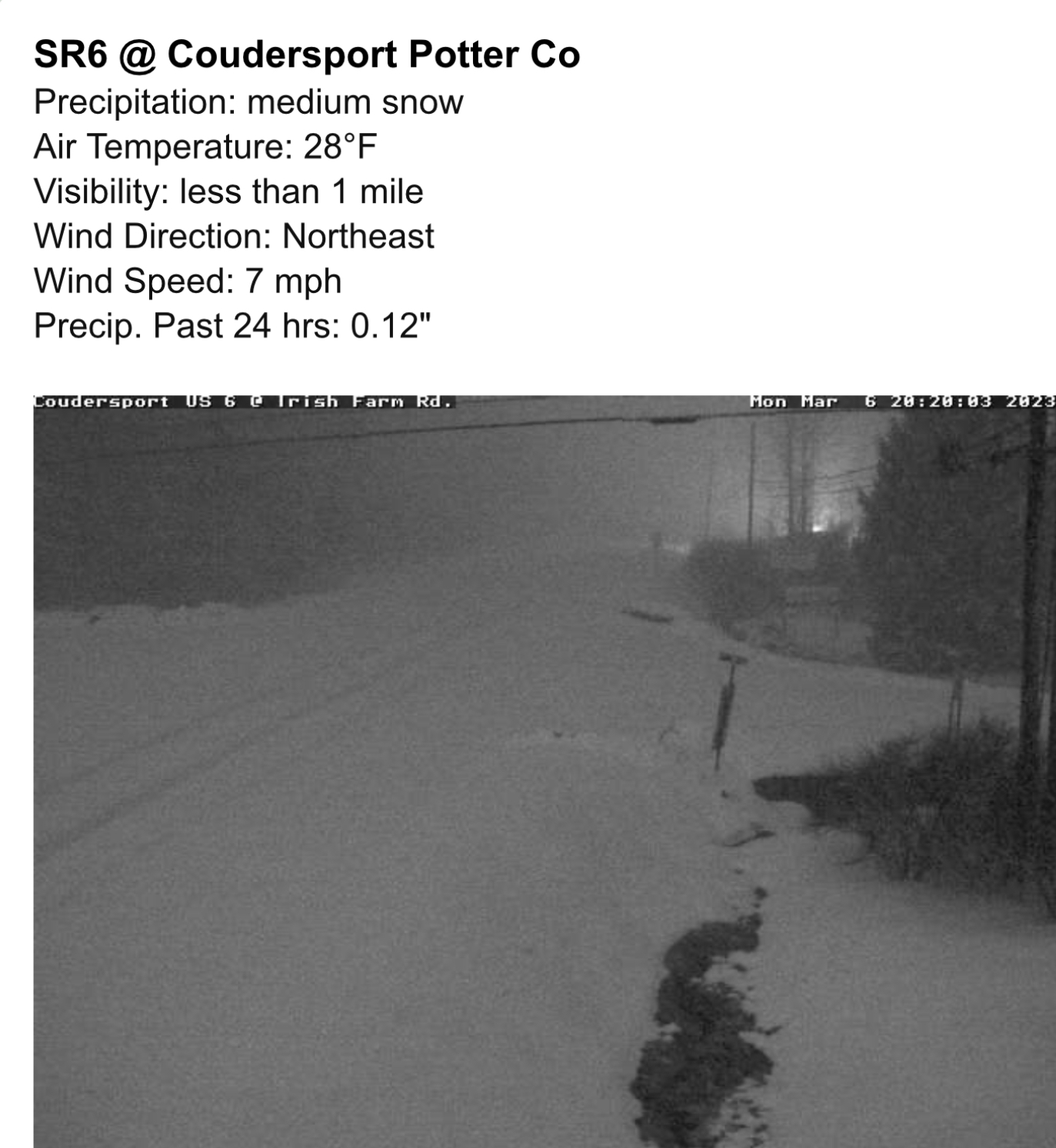
MAG5035 replied to paweather's topic in Upstate New York/Pennsylvania
Certainly looking pretty good for verified warning totals pretty much where they have them placed looking at current radar trends with that heavy band. The few 511 cams and RWIS up on that US 6 corridor are already getting pounded by heavy snow. I’ll bet PA 144 and 44 between Renovo and Coudersport is quite an adventure right now. US 219/US 6 US 6 east of Coudersport
-
The Ides of March end of Winter 2023
MAG5035 replied to paweather's topic in Upstate New York/Pennsylvania
It might not matter for most in here but that Monday night event is intriguing, especially for the IPT folks and maybe atomix. Only the Euro really took the snow swath thru the heart C-PA up until the last few runs where other guidance is focusing northern third to half of PA after mainly being PA/NY border and north. Low tracks just south of PA but cold is marginal. Best QPF swath will run along a thin ribbon of F-gen forcing, wherever that may set up. Best bet is probably above I-80 and maybe dropping under that some in eastern PA but if the boundary trends south a bit this could get places like UNV and middle Sus between MDT and IPT more involved. Would be a quick hitter but could be some good rates (and respectable ratios) within that F-gen forcing induced band. Guidance is putting up some pretty significant snow totals. I dunno about widespread warning amounts in northern PA but most non Euro guidance in fact has just that. NAM and new GFS op have a swath of 10”+. Certainly a swath of advisories look to be a pretty good likelihood. -
The Ides of March end of Winter 2023
MAG5035 replied to paweather's topic in Upstate New York/Pennsylvania
There was an opening at CTP back in early November that was part of a large posting for something like 26 openings in 21 offices. The only offices in the NE/Mid Atlantic in that posting were CTP, Binghamton and Caribou, ME. I actually put in for CTP but got the all too familiar “eligible but not referred”. -
The Ides of March end of Winter 2023
MAG5035 replied to paweather's topic in Upstate New York/Pennsylvania
Models have definitely been having issues on how they want to ultimately eject this shortwave out of the west. I tend to think op guidance (esp GFS) seems to be hanging this back too much and allowing a lot of heights to build ahead. I’m watching for now and staying open to all options though. Euro was the one that ultimately caved to yesterday’s storm around D5 when it was putting out snow runs similar to last night’s 0z. One thing I’m fairly certain about is regardless of what this system does, the aftermath is going to set us into a longer term colder than average regime with a mid-month period that looks to be significantly colder than average. Models were picking up on this system all the way outside D10 as it is a major feature that represents a more wholesale pattern change and is likely the direct response of the MJO having moved into phase 8, the WPO/EPO nosediving all the way into major negative territory, the PNA neutralizing, etc. It’ll definitely be the catalyst for the pattern change but the big question is will the blocking be enough to keep it under us and bring about this change with a snowstorm up front. It can’t hang back and build heights or we probably have the same ordeal as yesterday with a late secondary attempt that’s too high for us. All bets are off afterwards though, I’d be surprised if we got out of the ensuing 10-15days without having had a legitimate shot at an event. -
The Ides of March end of Winter 2023
MAG5035 replied to paweather's topic in Upstate New York/Pennsylvania
High gust so far recorded on my weather station has been 38mph, but it has almost certainly gusted a good bit higher than that at times. The house seems to shield the station a bit from SW type winds. Had a brief loss of power as well, which hasn’t happened here in awhile. -
The Ides of March end of Winter 2023
MAG5035 replied to paweather's topic in Upstate New York/Pennsylvania
Pingers and 33ºF. Measured 1.2” of snow at the transition. -
The Ides of March end of Winter 2023
MAG5035 replied to paweather's topic in Upstate New York/Pennsylvania
I’ve been busy the last couple days but I wasn’t sure how things were going to fare when the short range stuff lost most of any kind of front end snow. Looked like the Euro and even GFS did better. Here’s how my rain/sleet/snow/less than a half inch forecast grid is going so far today. Over an inch on non paved.
-
Central PA Winter 2022/2023
MAG5035 replied to Blizzard of 93's topic in Upstate New York/Pennsylvania
I also added the 925mb to that post as well, I had hit post before I was done with it haha. -
Central PA Winter 2022/2023
MAG5035 replied to Blizzard of 93's topic in Upstate New York/Pennsylvania
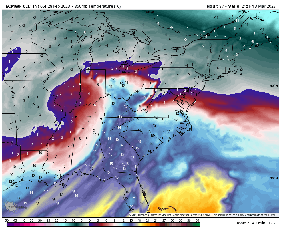
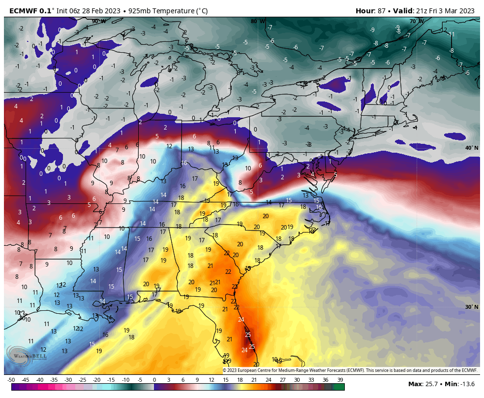
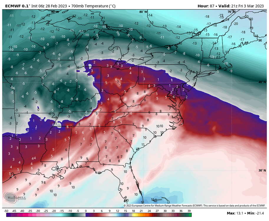
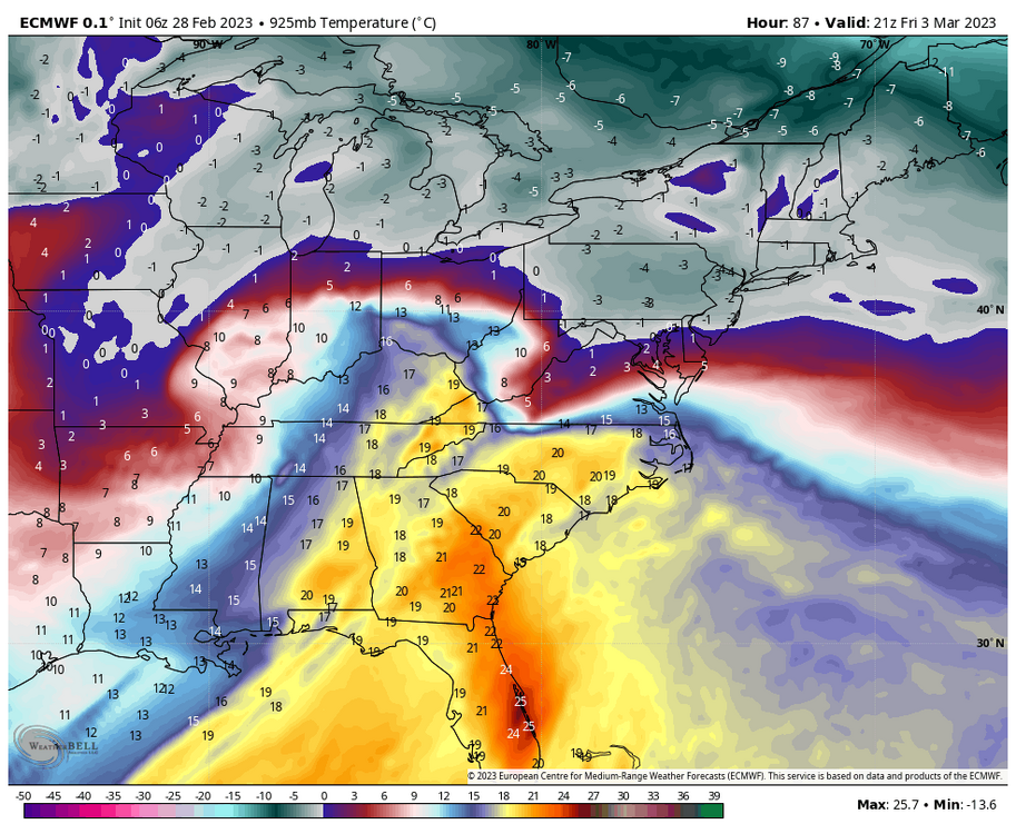
Yea that mid-week wave was what was bringing the frontal boundary down to set the edge for Friday. Friday’s event has been timing somewhat faster and the mid-week wave really hasn’t been pressing the front either. Spacing is definitely an issue, but so is the strength of Friday’s system. An already bombed out 976mb coming up the Mississippi out of the Ozarks isn’t ideal. It responds to the block and tries to secondary but the primary is too strong. There’s going to be some kind of a mix event for most or all of C-PA with this, but going to have to figure out thermals. Most guidance places a deep wedge of low level cold east of the Alleghenies all the way up through 850mb. Typically that’s enough to ensure what would be a significant period of front end snow, but there is prolific warm advection all the way up at 700mb (10k feet) due to the very strong 700mb low associated with the mature primary well west that would cut into that potential. That elevated of a warm nose would indicate to me sleet would be a predominant p-type for a while. I will say when it comes to the more mesoscale thermal features that are common around here I personally prefer the Euro when it comes to global guidance over the GFS… and then short range/high res stuff once it’s close enough. So here was 6z Euro. Hr 87 temps at 925mb Same hour at 850mb Same hour at 700mb
-
Central PA Winter 2022/2023
MAG5035 replied to Blizzard of 93's topic in Upstate New York/Pennsylvania
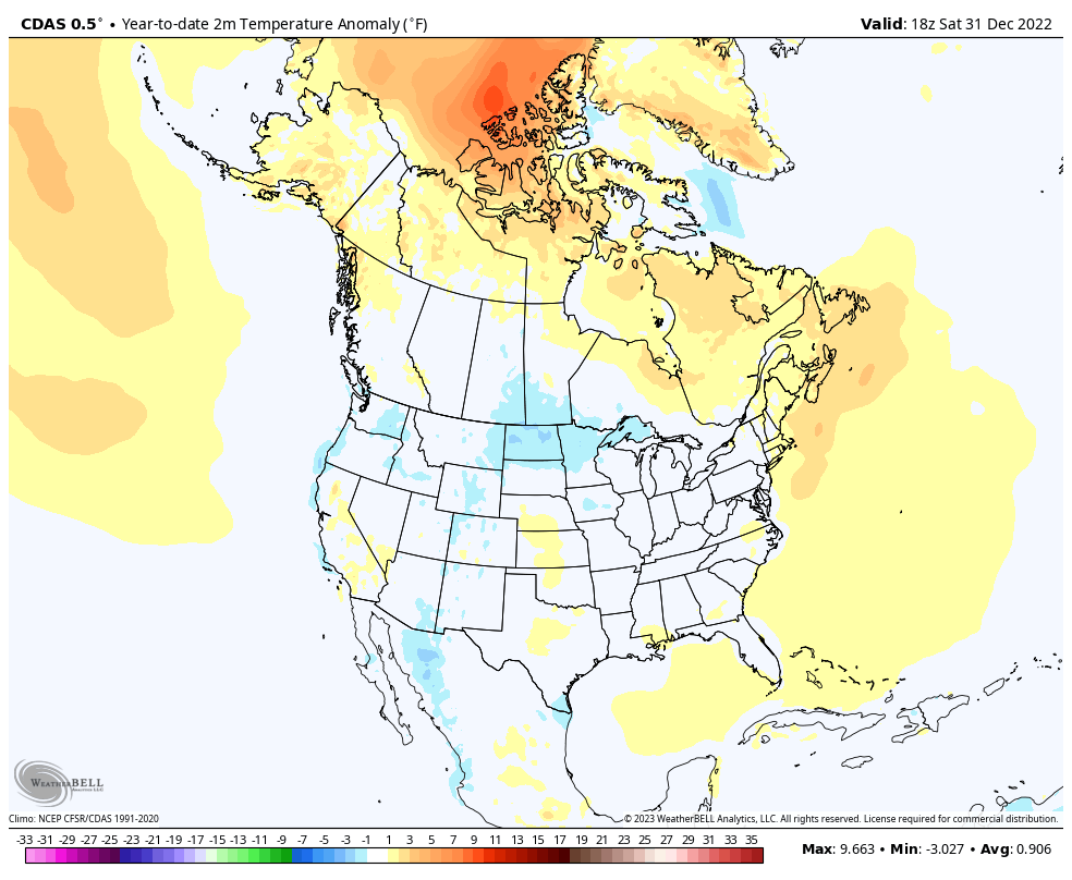
30 or so is a bit of a stretch, C-PA has had below average months as recently as October and December. This was 2022 as a whole.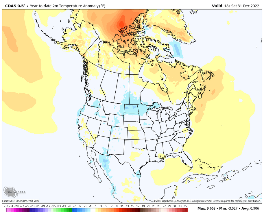
-
Central PA Winter 2022/2023
MAG5035 replied to Blizzard of 93's topic in Upstate New York/Pennsylvania
That stuff on the doorstep to R-ville looks like it means business. -
Central PA Winter 2022/2023
MAG5035 replied to Blizzard of 93's topic in Upstate New York/Pennsylvania
511 cams showing least a coating on the ground and some slushy roads in and around State College down I-99 at least as far as Port Matilda and possibly Tyrone. Some sleet accum on the grass here. Trying to changeover here but surface temps still a bit warm (around 36ºF). -
Central PA Winter 2022/2023
MAG5035 replied to Blizzard of 93's topic in Upstate New York/Pennsylvania
It’s game time here with the heaviest portion of this precip area moving through the next couple hours. Doing all three things currently, moderate rain/sleet/some wet snowflakes. 37/35º, 0.40” precip for the day, 997mb pressure, max gust today 28mph. -
Central PA Winter 2022/2023
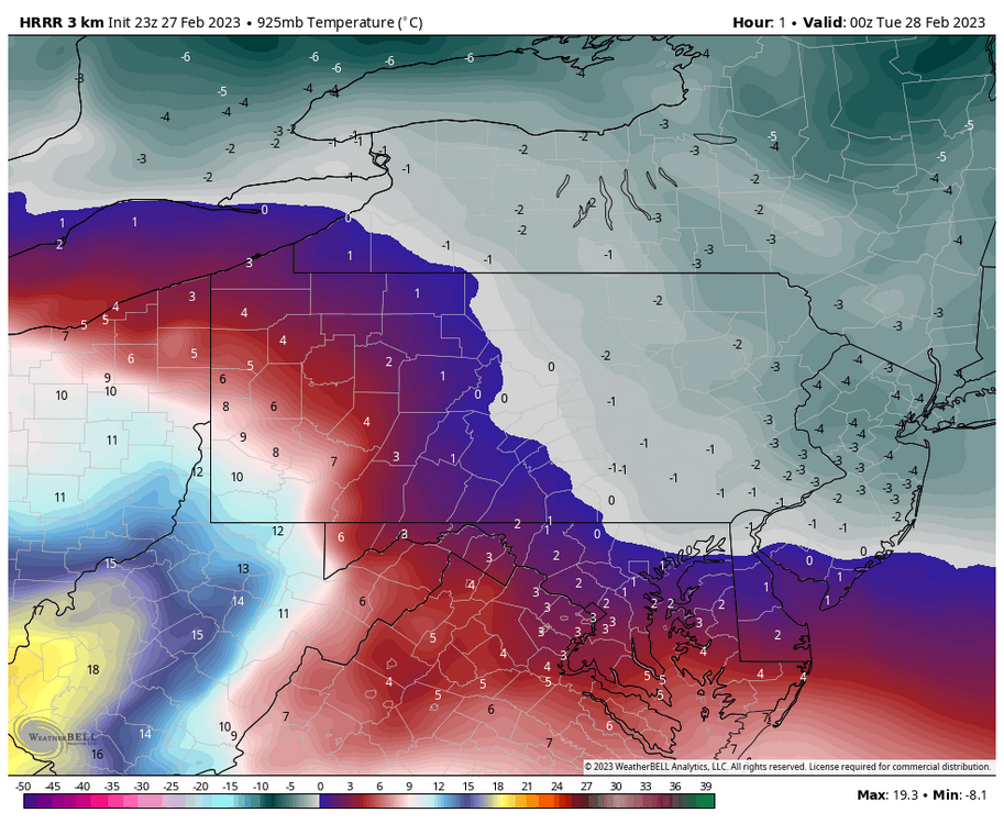
MAG5035 replied to Blizzard of 93's topic in Upstate New York/Pennsylvania
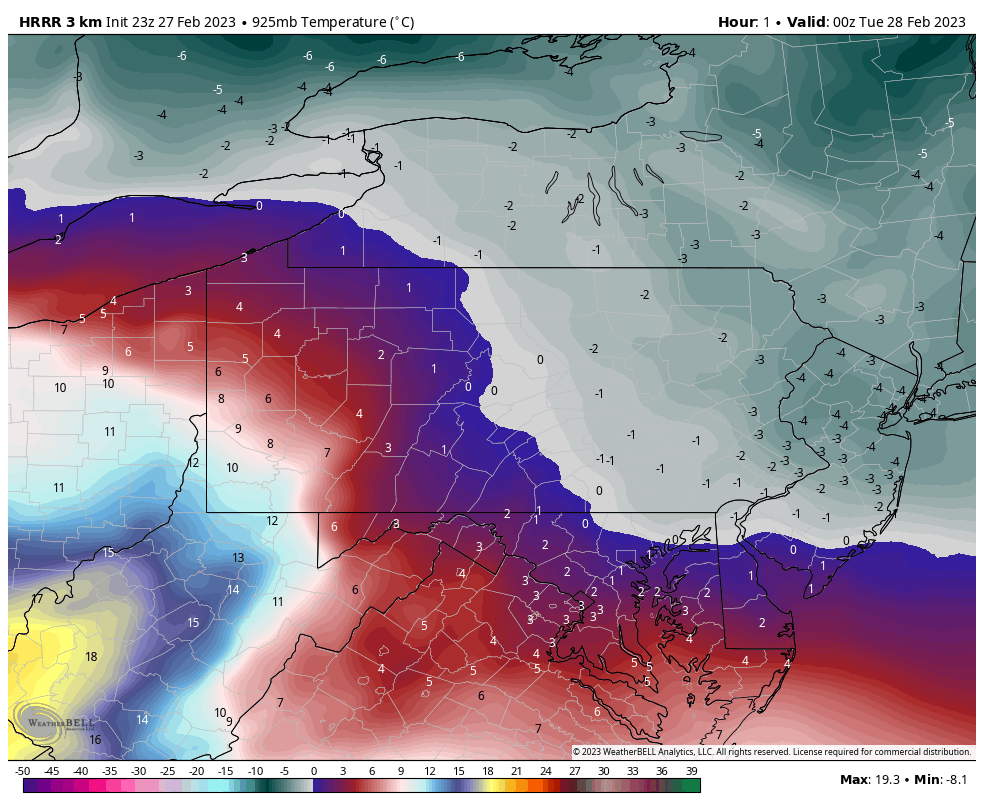
Here’s the current initialized HRRR temps at 850mb and 925mb. 850mb 925mb Very marginal column up through 700mb but one that is a bit below freezing at the major low levels in eastern PA. The stuff that is currently pinwheeling into western PA and the Pittsburgh area is eventually the area of heavier precip that could drive a full changeover to snow for a brief period later tonight when that gets into the temporarily anchored low level cold temps east of the Alleghenies. That starts in the central counties roughly around UNV and I think that stays above Harrisburg mainly but since there’s some mixing pretty far south into the LSV we’ll have to see.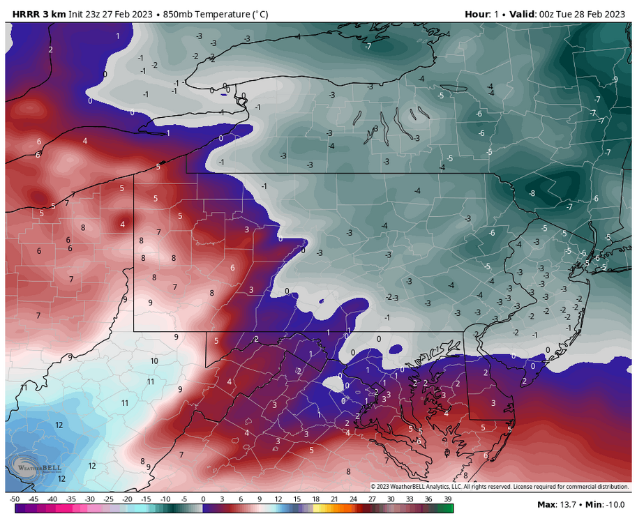
-
Central PA Winter 2022/2023
MAG5035 replied to Blizzard of 93's topic in Upstate New York/Pennsylvania
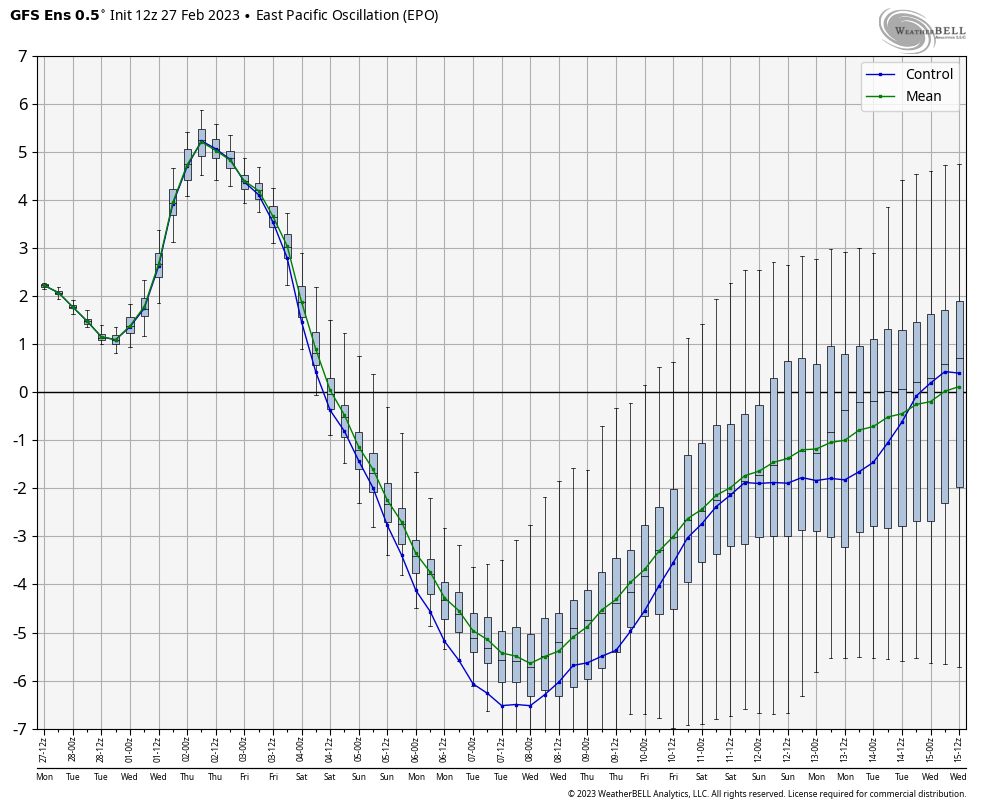
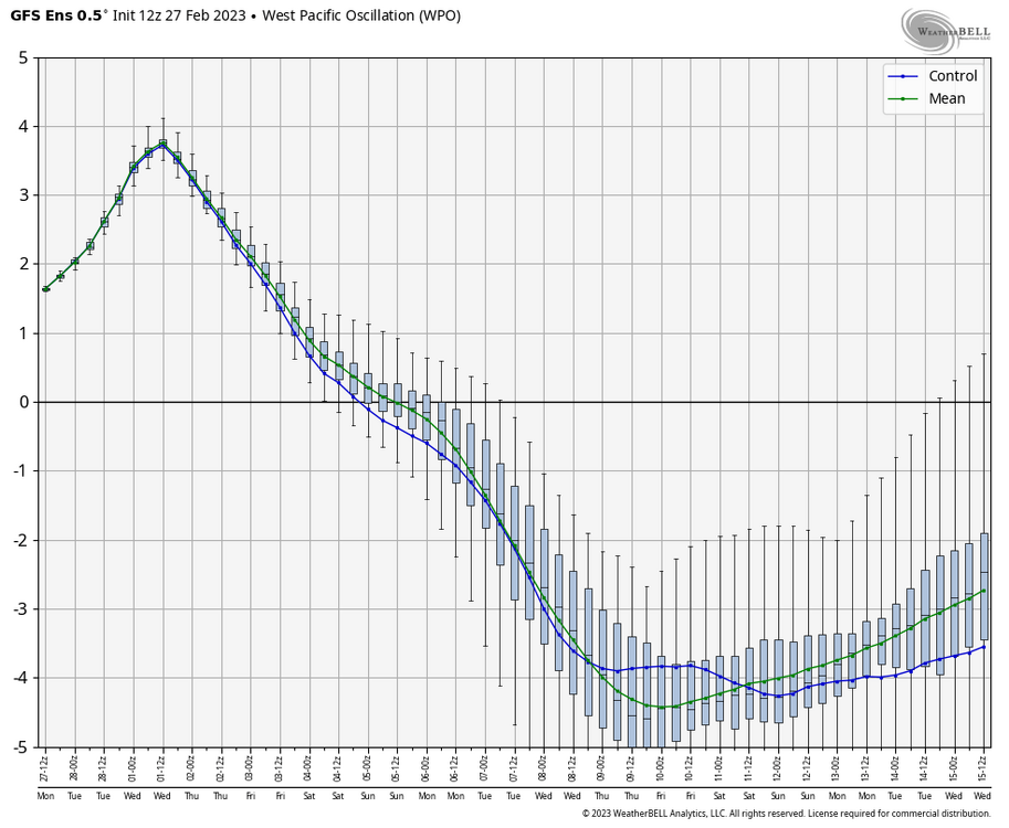
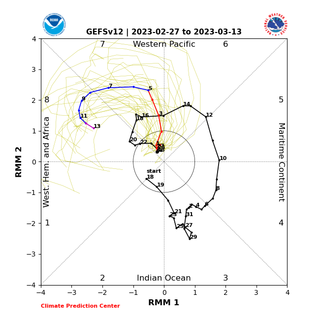
To answer your question from yesterday, here was a portion of my post from a couple days prior back on Friday.. which actually also refers to a post the day before haha. My thoughts are usually around but they typically get buried when it gets active and the snowmaps start flying. So with 3 days advanced since that post there’s no changes to that opinion although as I’ve mentioned the last couple posts for the late week event that I was really high on the potential. It’s crazy how sideways this went in the last 24-36hrs on the progs.. and the last couple days overall when the Euro had the main snow swath to the south of us. Storm gets too wound up too early. It’s going to hit the block and try to go to the coast but that strong primary is going to get west of us instead of sliding under us by the looks of it. The result is instead of honing in a mostly snow event for C-PA it’s going to be trying to figure out the degree of front end and mixing (sigh). I think if we stay as is with what most guidance has as the track today that we probably eventually correct to having some kind of a reasonable front end with resistance at the low levels, especially east of the Alleghenies. Global models have been presenting various degrees of mixing amongst various different scenarios of WAA aloft. That won’t start being resolved until we get into range of the short term/high res guidance. At any rate here’s where we’re at this week during these two events EPO WPO MJO So first off, MJO is squarely in phase 7 during this timeframe, some of the other guidance touches all the way back into 6 the next couple days with the loop. Pretty much everything isn’t getting into 8 after the first week into March (generally 7th to 8th or so). Phase 7 MJO isn’t ideal for storm track as it still favors southeast ridging. Like I mentioned, we probably can get away with a weaker storm sneaking under us but not a wound up 970s low coming up into Missouri. The first two charts are the EPO and WPO, the gigantic reversal to negative doesn’t completely occur until pretty much the timeframe that the MJO gets to 8. This big shift occurs (and the MJO to 8) right after the late week storm timeframe. These are all the keys to the pattern change we’ve been looking for. We haven’t made it into 8-1 all winter in the MJO and the brief time the WPO was negative was the arctic discharge in December. -EPO has also coincided with our brief winter opportunities/attempts. So the fact that all those teleconnections are headed that way while the stratwarm induced high latitude blocking (-NAO) is already getting established probably bodes well for a cold/unsettled pattern setting up for us. The EPO/WPO flip allows for direct arctic sourced cold into the US which will press across the CONUS even with some western troughing (-PNA). In the pattern related post I had before the above one I quoted, I was lamenting the fact that the MJO backtracking was going to delay this occurring. If it would’ve driven right into 8/1/2 I think we would’ve been rocking right now. Instead we’re probably talking mid month and onward. You can see the response of these aforementioned teleconnection flips in the longer range of the deterministic guidance/ensembles now.. not just the weeklies and extended GFS. There’s a cold period coming. It’s getting close though in the meantime this week, this current system tonight is going to finallly get NYC solidly on the board with a decent event. The interior upstate NY/New England over to the top third to half of the 95 corridor is starting to catch up on snow departures.
-
Central PA Winter 2022/2023
MAG5035 replied to Blizzard of 93's topic in Upstate New York/Pennsylvania
I would’ve assumed it’d be too windy to fly one in lol. -
Central PA Winter 2022/2023
MAG5035 replied to Blizzard of 93's topic in Upstate New York/Pennsylvania
Already issuing the it’s too warm for snow watches this week when it probably makes a run at 60ºF Wed/Thur ahead of this system lol. I hate to be the counter to all the good model runs overnight as I’m pretty high on this storm threat for us but can’t forget the GFS/GEFS which is still running it’s track (mean track on GEFS) too high and it’s kind of went the wrong way for us a bit in the 0 and 6z runs for that. I’m sure there’s still front end in that scenario but I’m go big or go home at this point. Like I said recently, if I saw another snow to mix/junk system in the next 10 years it’d be too soon. This one’s going to have a big snowfall swath for someone, so hopefully it’s us. -
Central PA Winter 2022/2023
MAG5035 replied to Blizzard of 93's topic in Upstate New York/Pennsylvania
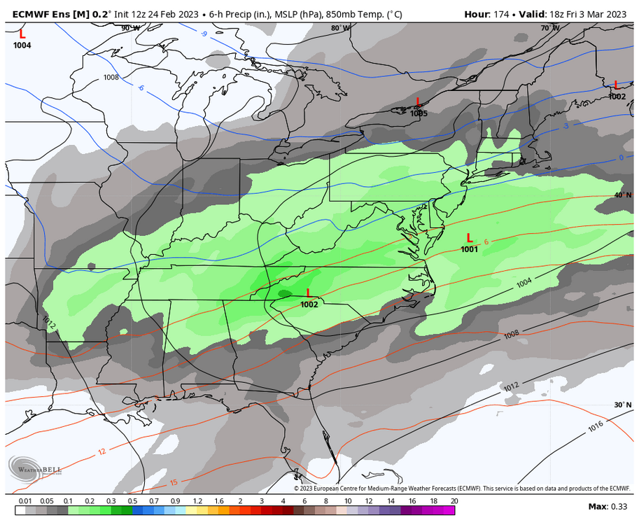
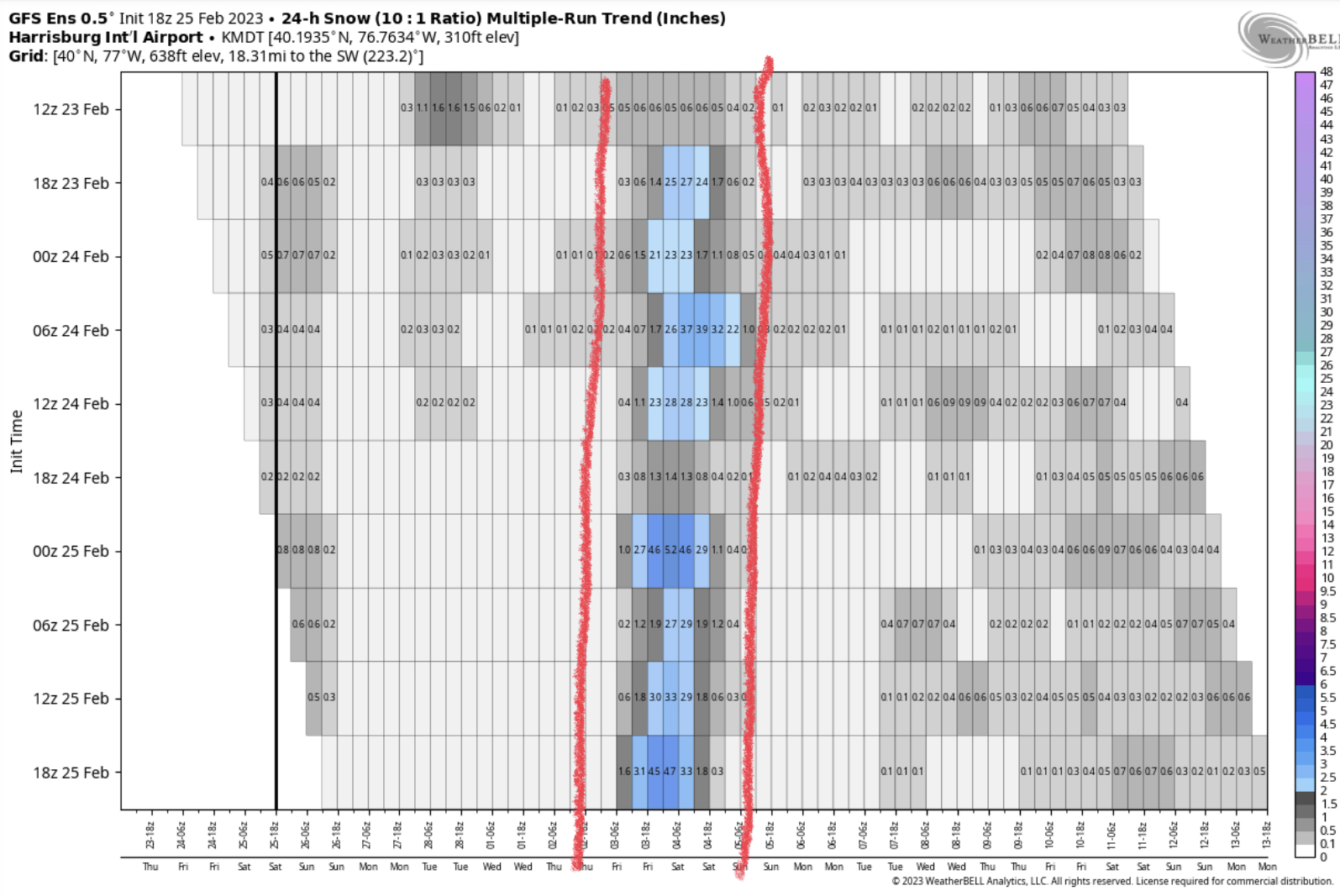
For the 3/3-4 event, it’s definitely starting to catch my attention with the Euro op starting to pick up on it the last few runs. GFS has been the most wound up of the bunch in terms of low strength, and today vs 12z the 18z has edged southeast a bit. Ensemble guidance has been painting pretty good support for a swath across C-PA that has been building. Trends, at MDT: Euro EPS: GEFS: Snow plumes at MDT: 12z Euro EPS 18z GEFS Several big hits in both ensembles and you can also see the difference between the two camps for Monday night with the Euro suite adding snow from that as well. The really big hits do drive up the mean but both ensembles are presenting most members showing accumulating snow and 18z GEFS has a little clustering of members in that 5-10” range. The thing with the GFS/GEFS suite is that it’s collectively more amped and rides that snow/mix line through PA. Early in the game for anything certain but I do like the signal for it.

-
Central PA Winter 2022/2023
MAG5035 replied to Blizzard of 93's topic in Upstate New York/Pennsylvania
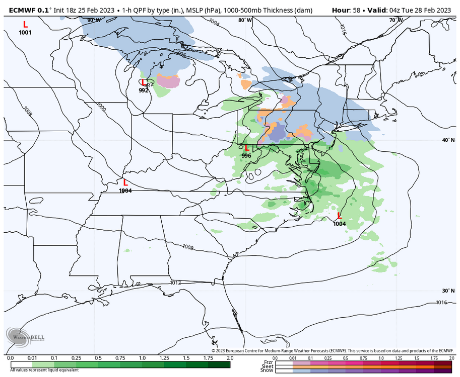
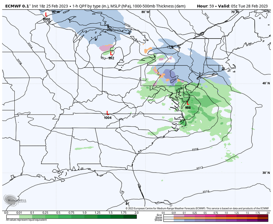
This Monday/Monday night thing is still fairly intriguing. The progged secondary low popping off the Delmarva acts to anchor solidly sub 0ºC 925/850mb temps east of the Alleghenies while the associated slug of precip crosses PA on guidance like the Euro/3k NAM while guidance like GFS/RGEM shows the same scenario but doesn’t quite pull in/anchor those kind of temps outside of about the NE quarter of of PA. It kind of presents a similar scenario to what we saw Wednesday with the arrival of heavier precip delivering flakes to places it wasn’t even in the forecast. Secondary low is key in this circumstance. Front end mixing is probable in spots as well but the main potential occurs when the secondary gets going. This possibility is being brought by the developing blocky regime up top and a 50/50 type low. 18z Euro by the hour: HR 57 HR 58 HR 59 See how the column aloft responds by cooling as the secondary low develops. These are also hourly plots. That darker blue is heavy 1-2”/hr type snowfall rates. So what’s on the table is after the front end mixing/frozen that probably favors interior central and NE PA (where this might be an all snow event) is a 2-4 hr period of heavier precip that flips to snow as the coastal gets going. And then also sort of similarly to last Wednesday, once this coastal moves away… we lose the column and eventually surface temps moderate going into later Tuesday and mid-week. But that’s after most or all of the precip is done. The warmth won’t be nearly as prolific as last week obviously.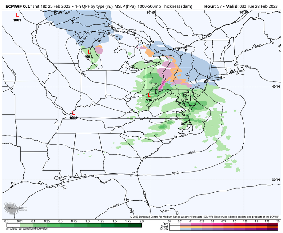
-
Central PA Winter 2022/2023
MAG5035 replied to Blizzard of 93's topic in Upstate New York/Pennsylvania
Regarding the 3/3 event, the Euro op might be doing it’s best GFS impression being the most progressive at the moment but the Euro ensemble mean does indicate there’s some support for the more robust GFS/Canadian type solution. The individual low tracks that make up that mean are definitely not anything resembling clustered but there is enough among the members to yield a half decent precip mean across PA considering range. I do think this particular event presents the best legit threat of a widespread wintry event in awhile for us but I like to reel this thing in a good bit further without it ending up heading to the lakes in the process before I get super confident about it. The much closer Mon-Tues event also bears a bit of watching as well. That one will depend mainly on development of the secondary low. Euro was the most aggressive developing a noteable secondary in VA to the Delmarva. The result was keeping mixed/frozen in NC/NE PA with the threat of some icing further south into central PA. I see that as more of an interior C-PA threat either way in the best case scenario given the alignment of the primary already in the lower lakes and the secondary developing a bit late. NE PA probably in the best position in terms of PA locations. The other aspect to that system would be preceding cold on the front end but there’s not much high support. Though low 980s primary to the lakes attacking a 1020ish high in Ontario is still a half decent gradient. Overall, preceding cold isn’t much to write home about but it may still bear some watching for the front end for some ice in spots. If we do end up hitting on that 3/3 event I’d actually consider it a bonus because even at that point we’re not set up in terms of the overall pattern other than the already established -NAO. The EPO/WPO nosedive starts occurring right after this event timeframe and most guidance doesn’t get the MJO back into 8 until after the first week of March. The result in the east is continued changeable weather in terms of temp anomalies and possibly even dealing with another cutter after the potential 3/3 storm. When it does get back there, it appears it may be of a much stronger magnitude. I touched upon those things in my post yesterday and how I think the MJO loop back served to delay this big pattern change that I feel has to come at some point given eventual lining up of all these supporting teleconnections.