MAG5035
-
Posts
5,882 -
Joined
-
Last visited
Content Type
Profiles
Blogs
Forums
American Weather
Media Demo
Store
Gallery
Everything posted by MAG5035
-
Central PA Winter 2022/2023
MAG5035 replied to Blizzard of 93's topic in Upstate New York/Pennsylvania
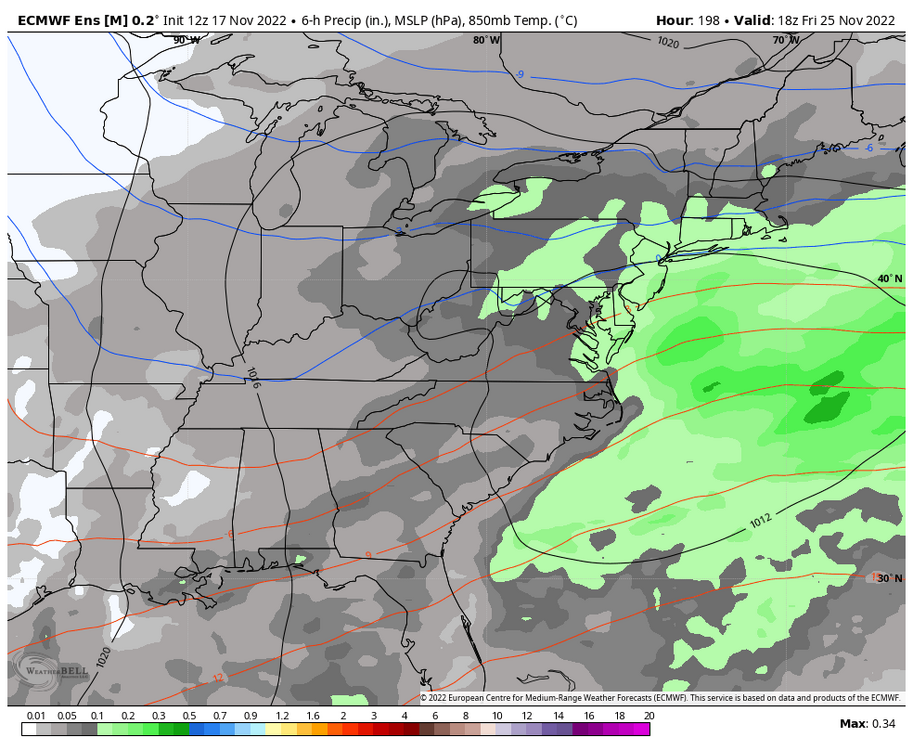
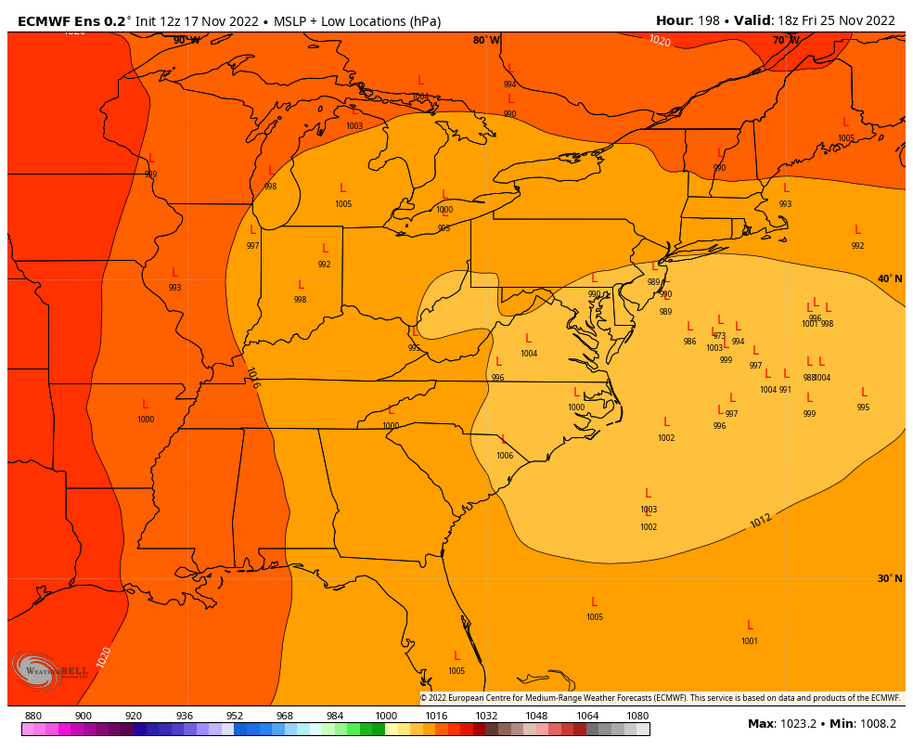
Model evolution since my last posting on Saturday has generally trended toward a more progressive secondary coastal low. And when I say “progressive” I mean it keeps on tracking into New England and beyond vs a stall and capture situation. That of course would take the Dec ‘92 2+day storm scenario off the table. What we seem to be looking at with this is a primary wave of warm advection precip that progresses into the region on Thursday, that perhaps enhances as we get development on the coast. Since this keeps moving, we’re going to be on more of a time crunch to get the column right for all snow. Basically, this is the scenario mentioned last week with the far west cutting primary hitting the blocking and forcing secondary development. We will have CAD and the actual secondary low on the coast (which wasn’t being modeled much at all at that point), so think most of the subforum sees a mix event up front, transitioning to snow in the interior counties as the coastal low gets going. Further south LSV (LNS/THV) is going to be dependent on coastal track as the low lifts up (could transition to rain if it’s too close) while upper LSV places like Harrisburg eventually transition to a period of snow. CTP mentioned in their AFD about dynamic and evaporative cooling of the column as well, which could imply a situation where the initial precip shield ends up being a thump of snow after brief early mixing. To put all of this simply, it’s going to be difficult to resolve p-type issues for awhile yet… per usual. -
Central PA Winter 2022/2023
MAG5035 replied to Blizzard of 93's topic in Upstate New York/Pennsylvania
All usual disclaimers aside on details, I agree on the Dec ‘92 similarities. We have the setup to deliver that kind of event. I said this 10 days ago on page 1 of this thread. So we have an assortment of possibilities on the table with this, including the Euro’s KO to the interior part of C-PA. I originally thought with the initial primary low cutting way west that if would be more of a front running frozen event (if there was enough cold/CAD) but models including the GFS now are really seeing this full on coastal development. Temps are def a bit of a concern for me, and if we get this Euro type stall/capture one will have to consider the easterly fetch.. which would surely be a highly anomalous type setup in that department. A very good thing for more interior/higher elevation places, but perhaps too much of a good thing nearer to the coastal plain (WAA aloft). Sus Valley would be a tough call with that scenario. Dec ‘92 was a highly marginal storm temp wise, Harrisburg went to rain after about 6” of snow if I remember my details right and State College still had 18” even after turning to rain in the middle of the event.. Jeff Morrow and the TWC crew drove the turnpike from Harrisburg to report at Breezewood (which had over 2ft). This may have a bit better of a CAD setup than that, but we still aren’t really incorporating truly cold air into the pattern on our side of the country yet. Still though, could be enough. To add to the suggestions I would maybe check Blue Knob State Park, not sure what they have for winter cabin rentals though. If the euro scenario came to fruition you would be ground zero there on a mountain that’s second highest to Mt Davis. Parker Dam is a good spot though. I’d watch to see how things go for a couple more days of course. The current broad model/ensemble consensus on a bigger event has my attention, but this still has a high possibility of being a more minor or mix-ier event. -
Central PA Winter 2022/2023
MAG5035 replied to Blizzard of 93's topic in Upstate New York/Pennsylvania
The funny thing is I was just looking at last year’s winter thread and we were talking about some of the same things we are now. A positive from this is that I don’t think we’ll see the western troughing to the degree we did last December and we’re working with a stronger -NAO. Recall the western pattern in December last year was such that it delivered a season’s worth of snowfall to the Sierras in California during a few weeks of December. (Before reversing the rest of the season). There was a lot of MJO influence last December as well (P6-7), while we’re in the circle with that right now. -
Central PA Winter 2022/2023
MAG5035 replied to Blizzard of 93's topic in Upstate New York/Pennsylvania
I’ve been trying to not get too high or low on modeling and the advertised pattern as we’ve gotten into the opening week of December. Two things i mentioned up front in my last post that opened up the winter thread was the -PNA and also the model mayhem trying to handle the blocky pattern. PNA seems to get lost at times when folks discuss the Pac and the other teleconnections of that realm (the EPO and WPO), so I’m glad to see it mentioned here. A week ago, I figured the PNA would offer resistance but ultimately a -NAO block of the caliber being presented would set us up favorably in what appears to be an active period for storms the next couple weeks.. and that modelling would eventually respond to more cold pressing. I’m sure most are aware of the whiplash of model solutions that have been shown in the last week or so. Looking at things currently, I certainly don’t think things are cooked by any means but I do think what we’re looking for will still come in a delayed fashion. To go along with the continued -PNA, the EPO is now forecast by guidance to go positive the next few to several days along with a WPO that had already been positive. After that EPO trends negative and PNA neutralizes on the progs. As long as that actually occurs, the pattern we’re looking for should come to us as the dominant -NAO/AO looks to stay established for awhile. In the meantime, we do have systems on the table that could end up delivering wintry precip. The nearer term Fri/Sat system seems to be the best bet. The NAO block will still be doing its thing and there is a strong surface high being progged up top. Even the GFS today put some snow in PA with that system. This should deliver something to at least the interior PA counties, with the issue being QPF. There’s no amp in the pattern, and this system will weaken as it attacks the block. Still though, this could be a 1-3” or so type event somewhere in our region before it fizzles. The system being progged around the mid-week timeframe next week looks to be a much stronger system and possibly the one that facilitates our awaited switch to the colder, more favorable regime. This one will likely cut or try to cut into the block. This could present an interesting situation that I’ve actually seen on some model solutions. With the strong blocking, it’s the kind of setup that could take the primary way west but still provide a period of wintry precip and/or snow if there’s even some marginal high support and lingering cold air. What then happens is the primary hits the block, occludes and forces a secondary somewhere on the coast. Will be something to watch… I still don’t think modelling has this pattern and specifically the -NAO blocking handled very well once to the mid-range. -
Central PA Winter 2022/2023
MAG5035 replied to Blizzard of 93's topic in Upstate New York/Pennsylvania
Just finished and posted this in the old thread before I saw the winter one was made, haha. Speaking specifically about our region (C-PA), a suppressed storm track would be a bigger concern to me than a cutting one with the establishment of a -NAO regime of the caliber thats been advertised solidly on the guidance (-3 to -4). Now truth be told, this is a great looking winter pattern upcoming for the eastern US once it does get truly established… which seems to be still in the realm of just beyond D7-10. So big question to me is storm track. The strong Greenland block would certainly suppress it, but getting completely overwhelmed with arctic air probably doesn’t help us either in the snow department. Being somewhere in between would be ideal of course. The -PNA is generally forecast to slowly neutralize but stay negative, which in this instance may be a good thing of keeping us in a more active gradient zone. There’d be great potential for something big if we were to line up a coastal with eastern CONUS cold in place and a -NAO induced suppressed (and blocked) storm track coupled with a very warm NW Atlantic SST wise. What also comes with a blocky pattern? Model mayhem trying to handle the individual features so I’d be looking for a lot of that as well -
Speaking specifically about our region (C-PA), a suppressed storm track would be a bigger concern to me than a cutting one with the establishment of a -NAO regime of the caliber thats been advertised solidly on the guidance (-3 to -4). Now truth be told, this is a great looking winter pattern upcoming for the eastern US once it does get truly established… which seems to be still in the realm of just beyond D7-10. So big question to me is storm track. The strong Greenland block would certainly suppress it, but getting completely overwhelmed with arctic air probably doesn’t help us either in the snow department. Being somewhere in between would be ideal of course. The -PNA is generally forecast to slowly neutralize but stay negative, which in this instance may be a good thing of keeping us in a more active gradient zone. There’d be great potential for something big if we were to line up a coastal with eastern CONUS cold in place and a -NAO induced suppressed (and blocked) storm track coupled with a very warm NW Atlantic SST wise. What also comes with a blocky pattern? Model mayhem trying to handle the individual features so I’d be looking for a lot of that as well.
-
It took awhile to find the time it was logged but apparently my WS-5000 logged a 60.2 mph daily max wind gust at 3:46 this afternoon. There were some decent gusts at that time of the day but not sure about that high of one. I have notifications set to alert for gusts >50mph and that gust was the only one to trigger that today. I suppose it’s possible.
-
Definitely a T lol, with 2-4” drifts out of the water spouts. Pretty unique as far as thunderstorms go. Wasn’t much wind that mixed down as we’re locked in with cool air damming. It’s finally cracked 40° after being in the high 30s all day.
-
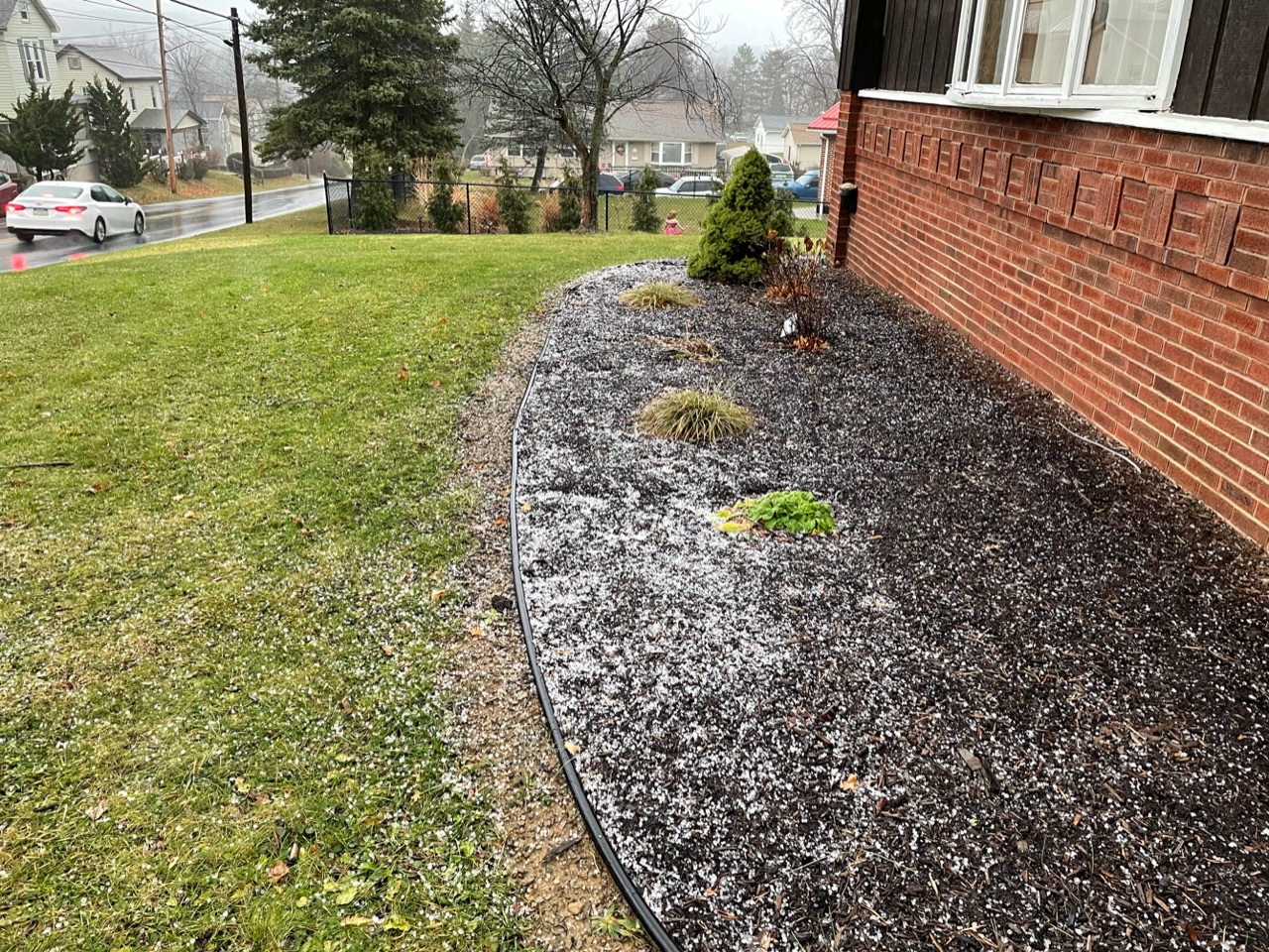
Well, that’s one way to get frozen in late November I guess… Only hailstorm I’ve seen this year and it’s on Thanksgiving weekend (with decent thunder/lightning).

-
You guys and your AC’s haha. Meanwhile my north facing snow patch is hanging in there. It did get to 54 here today (with low humidity).
-
The big issue I see getting into the opening week of December or so is despite the good teleconnection progs in the NAO/AO/EPO realm, the development of a pretty negative PNA in the interim is going to drive up the SE ridging. I think the evolution to this was probably a factor in losing the chance of our weekend system being anything wintry, that and the complete loss of a high pressure to the north that was a key factor in the wintry solutions several days ago. In contrast to last December, which also had a really negative PNA (much more negative at one point than what is currently being forecasted on model progs), we have the other teleconnections looking half decent going forward. We also have MJO influence that is currently in Phase 6, that should progress into colder phases (for NDJ) 7 and perhaps 8 eventually. I think we’ll get to where we need to for a good period of potential winter mischief, but it probably comes at some point during or more likely… after the first week of December.
-
It does appear the 12z Euro ensemble maintains a storm signal in the Thanksgiving weekend timeframe. Really not that bad of an ensemble signal considering the range either.
-
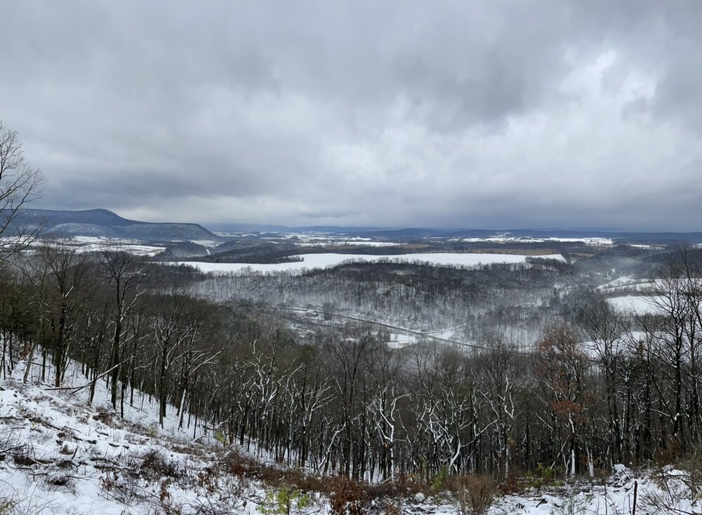
Forgot to post this pic from going hunting yesterday morning. This is from Rothrock State Forest in NW Huntingdon Co. The snow shrunk a good bit of course, but there is still a majority of the ground that has a pack today here. Also received an inch of new snow in the early morning hours today from the LES/upslope.
-
Canadian has the storm but much slower than the GFS, thus allowing the high pressure to position too far east and have maybe an interior ice set up on retreating cold with a primary low heading to the lakes instead of a redeveloping coastal. One thing about the Canadian progged high is it is much stronger (~1048mb). Something is definitely afoot here in this Thanksgiving weekend timeframe. It seems models all have the pressing high that probably eliminates the continuation of whatever moderating trend towards average we have around mid-week next week, and they all currently have some kind of system... So we’ll see if that continues. Funny I just made a post about the whole coastal thing last week, since the popular opinion for this winter is a reduced threat of them. The 12z GFS scenario sort of illustrates the potential I alluded to in that post if we do line things up for a coastal.. especially in the early part of the winter.
-
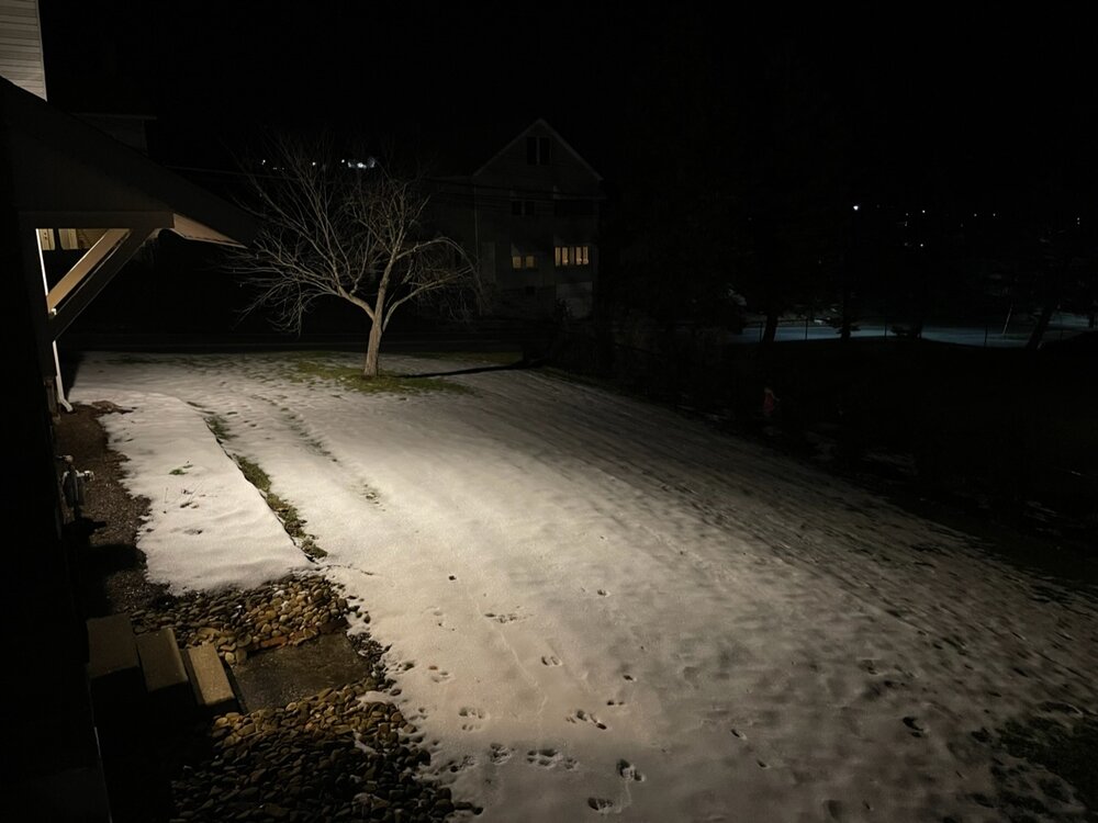
Okay, now we’re pinging here. We’ll see if the snow fights back with some of the last heavier parts of the precip shield but that 5.5” might end up being max depth.
-
5.5” now, really close to verifying a warning. The last heavy burst was also very close to sounding the pinger alert with really rimed stuff mixed in. In a lighter area at the moment (still light snow)
-
Just measured 4.7” with continued moderate to heavy rates. Some sign on radar of mixing trying break into this area from the SW, but the best precip rates are also about to move on from here as well. The damage is done though either way, what a nice snowfall event.
-
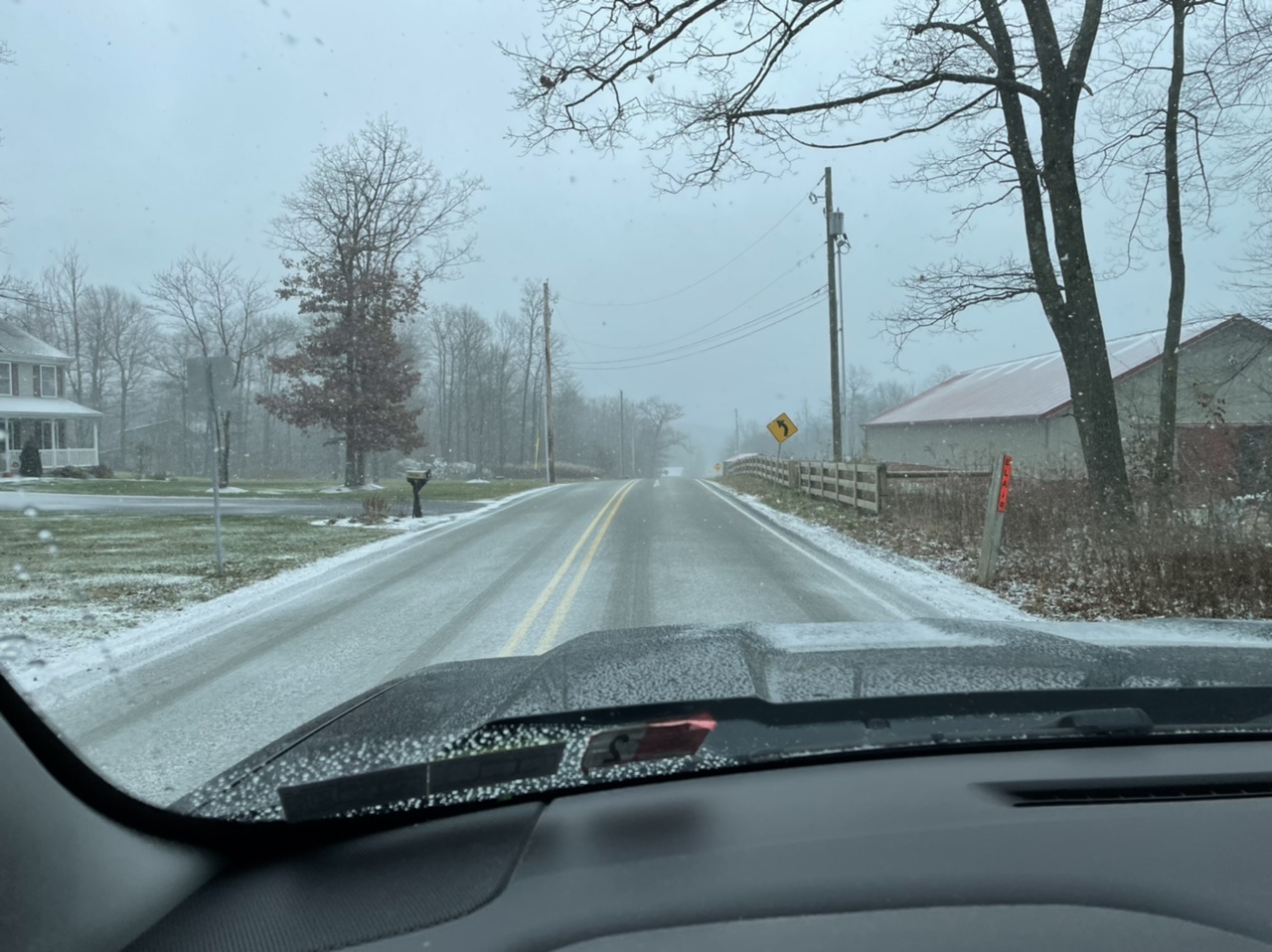
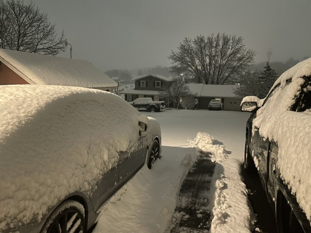
Heavy snow right now with 2.5” on the ground as well. It’s went from a more variable rate and occasional burst of half dollar flakes to that classic mid-storm flake size (smaller but piling up) Temp steady near 31ºF and most if not all roads are caved. 3-4” seems like a pretty big likelihood at this point here. Starting to wonder if this overachieves and takes a crack at 6”.
-
Update: 1.4”, 30.7/30°F, and moderate rate. There’s been some nice heavy bursts of snow at times.
-
Sorry lol, definitely snow. Pretty steady light to moderate and starting to lay on the grass at home. I’m out doing some errands. Top of Wopsy is 28° and it was already laying easy up there and blowing around with roads starting to cave. 31-32° down here in town so not quite to caving roads yet. About 20min ago on top of Wopsy (~2400’+)

-
Steadier stuff has arrived, light right now. Temps right around 32ºF. For those that were wondering, it does appear they have CCX (State College) radar up for the event today.
-
Flurries here, it’s looking to get going pretty soon. Temp and dewpoint just a hair under 32/25°F. Yard is ready to go

-
Down to 24.6ºF here. Been busy today getting the yard the rest of the way cleaned up, putting the riding mowers in the storage garage and bringing the snowblower back to the house today. I’d say there’s a half decent chance of being able to use it here. I’m definitely excited to see some early season synoptic snow. Given the look of the forecast the rest of the week, if this advisory type event materializes here.. it’s likely to stick around for a bit. Models are generally on board but a couple differences, especially with the 3k NAM being the warmest. A lot of that QPF is being generated as freezing rain on that. I think this is a pretty cut and dry snow vs rain situation, where the main slug of WAA precip cools the column to allow for snow on a pretty widespread part of the area. ZR impacts likely come after the main shield of precip lifts north, and I think that will be mainly relegated to the central ridges in minor amounts. Main things to figure out IMO are how much of the Sus Valley gets involved with seeing a period of accumulating snow, and top end amounts in the central counties. I’d say H-burg could go either way with at least seeing some snow stick or perhaps seeing a more notable period of accumulating snow (1-2” variety). York/Lancaster and that part of the LSV a little bit more in question. It may mix down that way but not sure about much in the way of accumulations. As for the other point with top end accums, I currently see this easily being a widespread 2-4 event in the central counties (JST-AOO-UNV-IPT), with a chance at some 5-6” at elevation on some of the ridges. Also noteworthy, it’s one of those cases the models are putting out bigger accumulations via the straight 10-1 snow maps vs the Kuchera method. Looking at thermals, the column looks good from a standpoint of supporting snow in that 4-6hr period when the best precip comes through… but not so much in terms of ideal snow growth. Still though, I think 10:1 is attainable when talking snow crystal growth. Marginal modeled temps at the surface and near surface level are likely what’s bringing Kuchera numbers down some, and I think the area that changes to snow and sees the best rates with the WAA slug (central counties most likely) will ultimately be a bit colder than modeled and not have much trouble accumulating snow. One other thing, not thrilled about having to track this event tomorrow with CCX radar down for that maintenance/upgrade lol. It figures that after what seemed like 30-45 days of dry weather that the scheduled 7 day maintenance period would see a significant rain storm and then the first widespread winter wx event of the season in that timeframe.
-
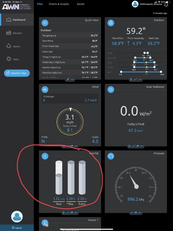
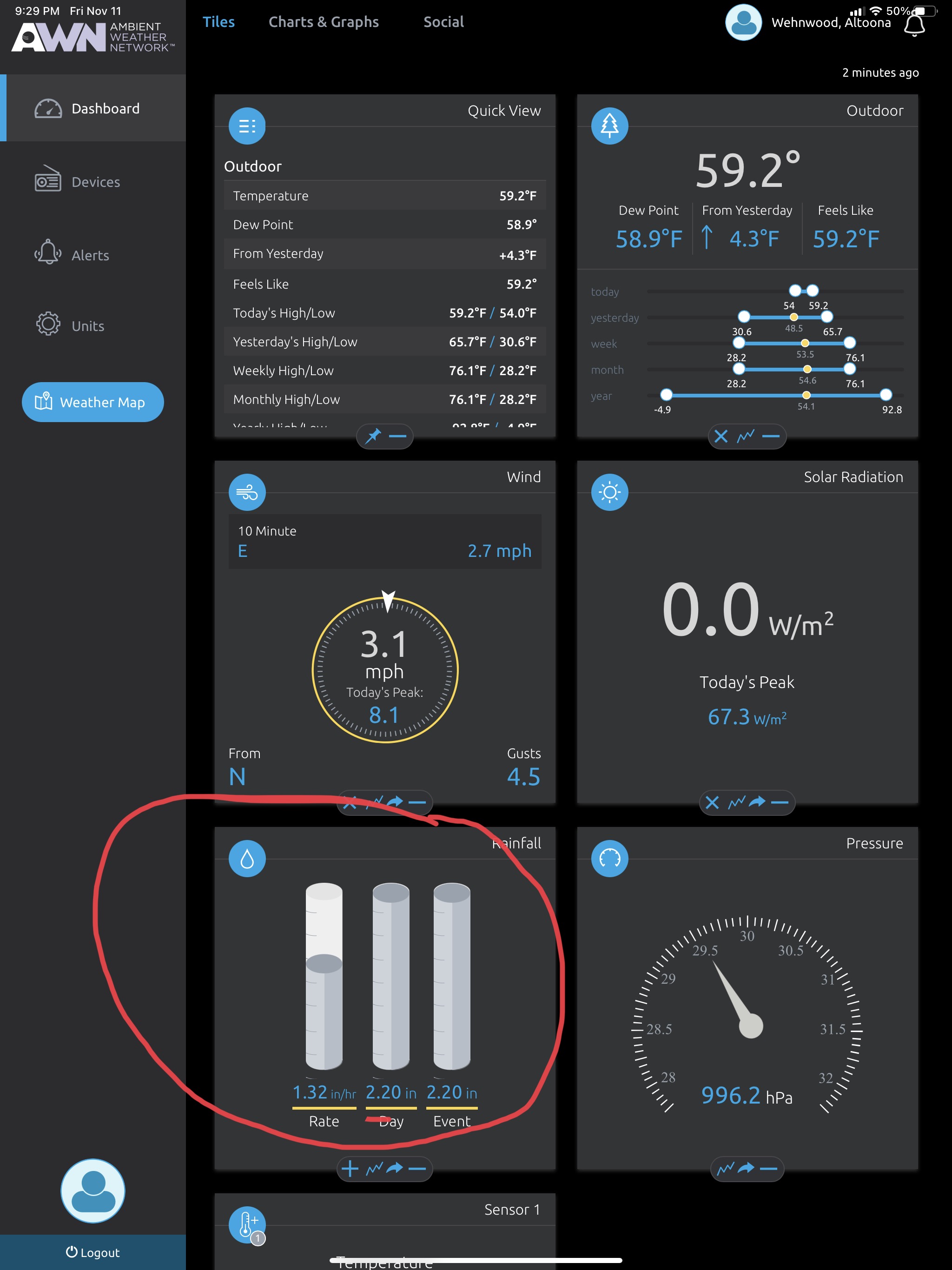
Surprised CTP doesn’t even have any flood advisory products up. Scanner app has lit up with all sorts of flooding issues in the usual trouble spots in the Altoona and surrounding area. Up to 2.89” on the rain gauge. Had a max rate of about 1.7”/ hour at one point.
-
Heavy rain being registered on the weather station at home. Also pressure down to 996mb 1.32”/hr rate and 2.2” total