MAG5035
Meteorologist-
Posts
5,882 -
Joined
-
Last visited
Content Type
Profiles
Blogs
Forums
American Weather
Media Demo
Store
Gallery
Everything posted by MAG5035
-
Central PA Winter 2022/2023
MAG5035 replied to Blizzard of 93's topic in Upstate New York/Pennsylvania
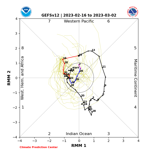
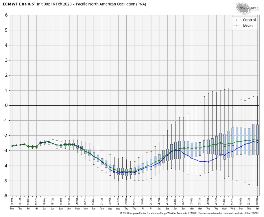
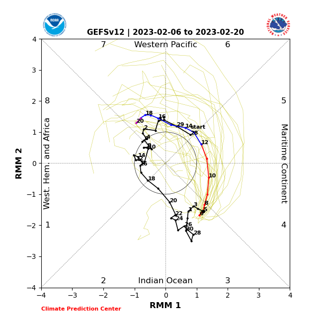
The significant cold anomalies in the SW US have been remarkably persistent most of the winter (much like the SE ridge on this side), specifically the last 30 days but on a month by month basis November averaged well below average as well. The only fairly normal month temp wise in your neck of the woods was December. Unfortunately the really negative PNA that has been firmly established as of late looks to continue unabated and that’s going to weigh heavily towards discharge of Canadian cold centering towards the western half of the CONUS regardless of whether we push some cold into C-PA eventually. Revisiting my post from last Friday: So nearly a week later now, MJO as of the 1x per day update this morning incorporating 0z data is on the border of Phase 6/7. A tad slower but it still moved and is moving rapidly through these warm phases. All the guidance does get it into 8 now in the next few days. Key thing they are showing now, is a curl back instead of further advancement into 1-2. Here’s GFS as an example: Now this is better than yesterday’s version of this forecast, as the GFS looped it right back into the P5/6 region by the beginning of March. That scenario would figure to be quite a blow to setting up any kind of wintry run during the first half of the month where you can still put together a cold pattern that can keep snow on the ground in our region. I’m still not really enthusiastic about curving back into 7 either, as the pattern for that phase still looks an awful lot like what the models have generally been suggesting… which in shorthand is available cold weighed to the west but trying to press the SE ridge… setting a storm boundary that we may or probably won’t be on the right side of. As I said in the quoted post from last week, I think we need to carry that pulse of tropical forcing at least modestly into the colder phases 1-2 as I believe that is needed to force a big shuffle of the status quo. In the meantime, here’s what we’re faced with. This is no bueno. This index has been a primary driver in this SE ridge and cold western US regime and will continue to give us trouble. I feel like the PNA gets overlooked for the EPO sometimes when talking eastern cold. That kind of magnitude -PNA is a very dominant signal to overcome with a +NAO/AO. I don’t even think the +NAO/AO would be a problem because there’s finally a lot of really cold air progged to build and be available in Canada that can press. The period the models have been occasionally showing some mixed/frozen events for us coincide with a forecast dip negative in the EPO. The cold will try to press but that SE ridge induced by the super negative PNA western trough is going to make it hard. The other factor is the stratwarm, which is definitely a thing now and occurring currently as a full blown SSW. I’ve pretty much viewed the MJO forcing as our primary factor in getting potential winter weather back sooner, perhaps before the month is out while the stratwarm was more of a long game type thing that, in lieu of the MJO not working out in the interim.. probably makes the back half of March into April cold anyways when we’re pretty much over it. The stratosphere thing is definitely interesting. If you brave the terminology and discussion in Dr. Cohen’s weekly posting, he considers this event possibly a unique example as models continue to weaken/even potentially split the strat PV after the SSW. That type of stuff would suggest eventual blocking in the NAO realm. Guess we’ll see, I’m admittedly not super knowledgeable and still learning when it comes to the stratosphere stuff. -
Central PA Winter 2022/2023
MAG5035 replied to Blizzard of 93's topic in Upstate New York/Pennsylvania
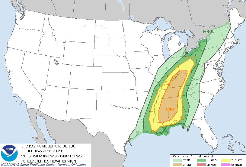
Temp here at home managed to crack 70ºF (70.2) yesterday. Here was some of the climo for yesterday per CTP. Bradford and Williamsport obliterated their daily record. Rainfall slated for today looks to come in two main parts.. a slug of rainfall that arrives around lunch time and lasts most of the afternoon and then another area associated with the frontal passage later overnight Thurs night/Fri morning. The stuff with the frontal passage may include some thunder but instability is likely to be elevated with low levels stable (cooler with the afternoon rain/clouds plus timing of FROPA later at night) in central/eastern PA. Latest HRRR that goes out that far (6z) tried to generate a little bit of CAPE in the Sus Valley right before frontal passage, likely trying to push a warm nose there. But again, I think convective elements are likely limited to potentially a few strikes/rumbles and maybe some gusty winds with the frontal passage. SPC D1 -
Central PA Winter 2022/2023
MAG5035 replied to Blizzard of 93's topic in Upstate New York/Pennsylvania
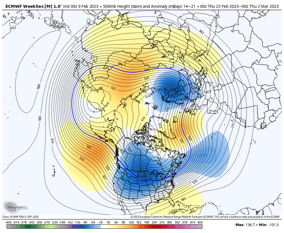
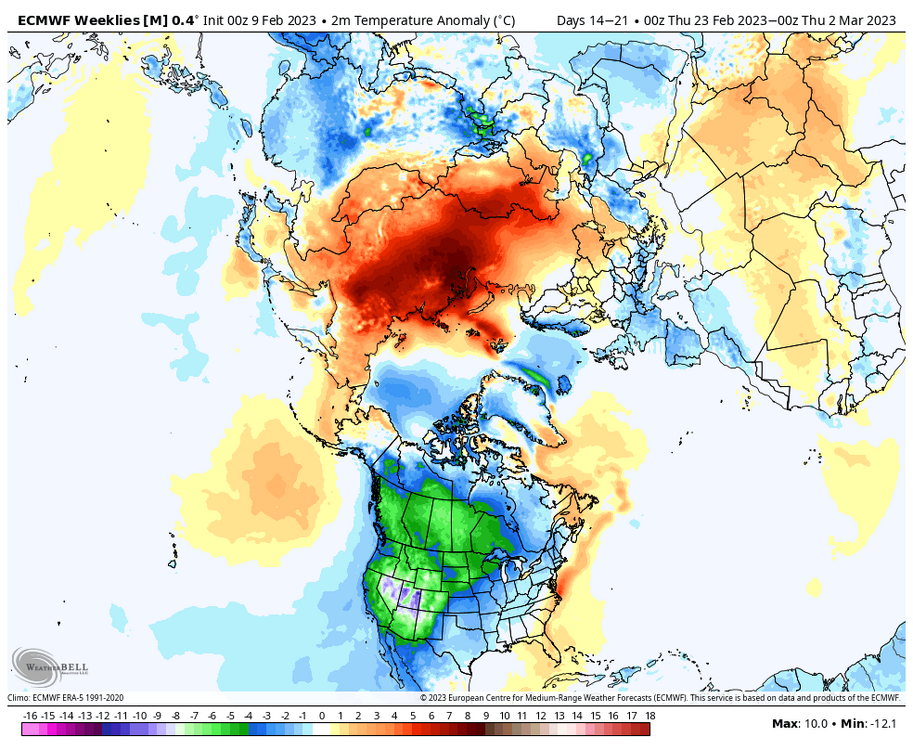
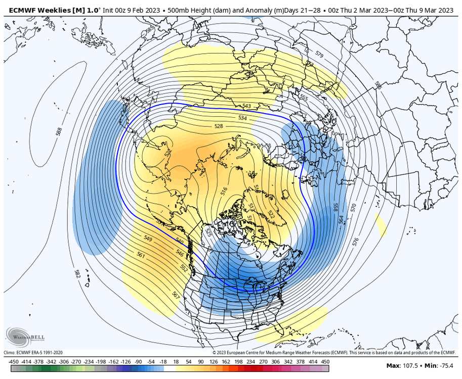
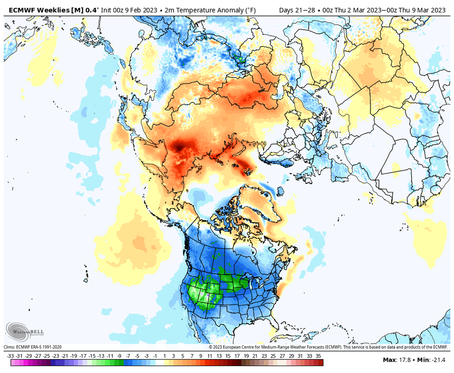
@canderson The GFS extended maintained some SE ridging (although a good bit colder overall in the east) but the latest run of the Euro weeklies that ran a couple nights ago definitely did not beyond week 2. It had the entire lower 48 cold with no SE ridging starting from about the end of week 2 the whole way through the end at D46. Week 3 (7 day anomalies) Week 4 It’ll be interesting to see what the MJO does. Most guidance gets it rapidly to Phase 8 as soon as the middle to latter part of next week. I think what happens after will be important, as maintaining convection in the 8-1-2 realm would probably go a long way to driving the wholesale change in the pattern at the mid latitudes we need to go on an actual wintry run. The MJO was persistently forecast to hit those phases in early to mid January but never actually emerged into any phase til it got to 3 late month. Theres also the stratosphere, as all guidance has been predicting significant warming and at least some stretching/displacement of the stratospheric PV and this starts occurring in the next week or so. The GFS/GEFS appears go as far as to try to split it. Either way, it’s significant enough that it will likely have an impact on the pattern down the road the next few weeks and a recent example of this is 2018. If it played out that way I think we’d be seeing snow opportunities well before Mar 23. -
Central PA Winter 2022/2023
MAG5035 replied to Blizzard of 93's topic in Upstate New York/Pennsylvania
It’s likely to be quite a + departure by the end of next week. The system following the weekend one we had been watching slated to cut next week seems poised to drive an even more prolific warm push out ahead of it, probably centering on Wed/Thurs. Probably a record or near record challenging warm shot for us. 1 day anomalies over the northeast are nuts with ensemble means of the Euro and GEFS showing +20-30ºF over our area and the rest of the northeast. Other aspect is likely a potential severe weather outbreak at least into the Deep South some of the Ohio Valley. 12z Euro manages to drive up non negligible SBCAPE’s of a couple hundred J/kg all the way up into Ontario. Not at all a common thing to be seen at our latitude and higher in mid February. Def has the look of having some thunder with the frontal passage either way. -
Central PA Winter 2022/2023
MAG5035 replied to Blizzard of 93's topic in Upstate New York/Pennsylvania
I mean I’m only describing what happens with calm winds at the surface and clear skies, radiational cooling. KABE is up to 48 now with a WSW wind blowing. There’s two other station’s in that area that are still cooler and others in the general area that have 20 degree differences between them. -
Central PA Winter 2022/2023
MAG5035 replied to Blizzard of 93's topic in Upstate New York/Pennsylvania
CTP added their climo section on with their latest update an hour ago. MDT hit 61 during the day but JST and AOO spiked up to hit 64 right before midnight. Temps are falling now back this way. The 64 at a place like JST is nuts this time of the year, though apparently it also happened in 1925. Looked like MDT spiked up to 61 again after midnight as well, just missing the 2/10 daily record of 62 set back in 1960. -
Central PA Winter 2022/2023
MAG5035 replied to Blizzard of 93's topic in Upstate New York/Pennsylvania
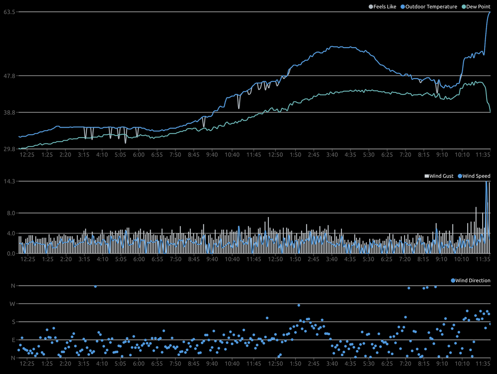
Judging by the calm winds in the obs I’d say that immediate part of town is decoupled and having radiational cooling at the surface since it’s currently clear in eastern PA. There’s a couple other obs (on Mesowest) in that area that are also in the 30s. It’ll spike once that wind and very wam air just aloft mixes down. Similar thing happened here earlier this evening as I posted about a bit ago. My temp had fallen to 45 during the mid evening and spiked to 64 just before midnight when the wind mixed down. -
Central PA Winter 2022/2023
MAG5035 replied to Blizzard of 93's topic in Upstate New York/Pennsylvania
Looking at the model guidance tonight, there remains some support in getting precip above the Mason-Dixon into the LSV, esp into parts of Adams/York/Lancaster. Most prolific precip maker was the RGEM, delivering a stripe of 1”+ QPF across that area in a deform band… which def seems to be an outlier. The issue I’m seeing as this threat starts getting dialed in is that even if we do get this to come up enough to deliver some precip up into southern PA, thermals may end up just a bit too warm.. or relegating any snow to the higher ridges in southern PA. That’s not necessarily because of the obvious warm air mass all around but that the storm itself matures and “stacks” all the way down in GA into the Carolinas. The dynamic processes driving the cold pool with the closed low and snow supporting column peak down there. The critical column levels in this situation (850/925 mb) modify as the matured storm tracks east below us and doesn’t track north enough either. We need this to be drawn all the way up the coast so we could not only see the precip but to get into the cold pool aloft to have a chance at seeing snow. I don’t see enough from the progged upstream northern branch feature (which i posted about yesterday) to allow this to draw up further either. The result is a more regional and elevational snow event centered on some portion of the southern/central Appalachians (def western Carolinas, eastern TN and SW VA). Most guidance gets measurable down all the way into at least the high ground of northern GA and I may be slightly amused that the 0z NAM tried to make Atlanta the “new Harrisburg” lol. I find it pretty wild that this kind of event is even on the table considering the current pattern we’re in teleconnection wise and being in the thick of a Phase 4-6 MJO run. But most/all of us are probably going to manage to be too far north to see a snow event with this anyways. -
Central PA Winter 2022/2023
MAG5035 replied to Blizzard of 93's topic in Upstate New York/Pennsylvania
The wind has finally arrived, and it has really spiked the temps. I had a high of 55ºF this afternoon and was down as low as 45ºF around 930pm or so with light winds. The wind arriving has mixed down the crazy warmth west of the Laurels and I think I might have you LSV’ers beat in the spring fling department at the moment. 63ºF at 1143pm, and it was as high as 64. Insane spike.. guess that’s good for about 40-45 degrees above average lows lol. -
Central PA Winter 2022/2023
MAG5035 replied to Blizzard of 93's topic in Upstate New York/Pennsylvania
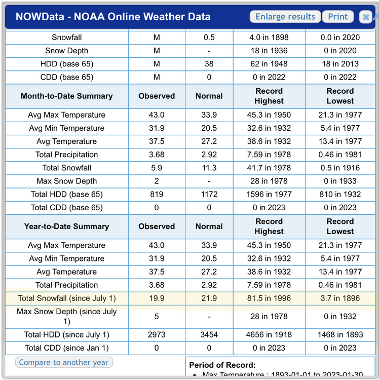
So I hear this winter sucks lol. I’ve been playing with the NOWData lately using MDT doing some previous year comparisons of how we’re doing this winter to date (thru 2/7). They have measured 5.9” so far this season, average to date is 17.2”. Winters in the last 30 or so that are comparable (within a couple inches) or worse. 2019/2020 (5.1”), 2016/2017 (1.9”), 2007-2008 (5.3”), 2006-2007 (2.6”), 1994-1995 (6.6”), 1991-1992 (1.7”), 1988-1989 (6.9”). Several others that were bad overall winters were below average in 9-12ish range. That leaves my favorite find of this deep dive… 1992-1993, which had 6” to date. Most of that came from the Dec 92 nor’easter that turned to rain in the Sus Valley, so some of the LSV was prob in worse shape than that. I always knew that 1992-1993 was a winter heavily weighed on the two big hitters in C-PA (the Dec 10-12, 1992 nor’easter and March 93 Blizzard) but I never realized how much that winter sucked in between for a whole two months until about mid-Feb with above average temps and little snow. UNV, hit hard with 18” from the Dec storm had only 4” from when that ended Dec 12th to Feb 12 with no single snowfall greater than an inch or so. Post Feb 12th they had over 70” (28” from the 93 storm) to total about 93”. MDT ended up with over 47” for the season. That’s one heck of a turnaround. -
Central PA Winter 2022/2023
MAG5035 replied to Blizzard of 93's topic in Upstate New York/Pennsylvania
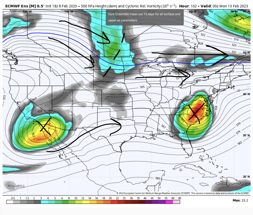
I dunno if I’d call progressive directly the problem here. Certainly the northern branch is progressive but this potential event has trended away from a tailing wave running along a frontal boundary into a closed off upper low cut off from that flow. The former scenario was one that required perfect timing and the latter scenario (what guidance has been showing as of late) is one that needs a way to get some latitude. Gonna show 3 panels from the new 18z Euro ensemble mean. Initially, there’s a shortwave in the northern branch that passes Friday Night/Sat ahead of the closed low in the south and a positively tilted trough orientation. 60hr At 84 hours, the closed low is cut off from the northern branch but progressing along with the upstream shortwave diving into California pressing. The key to getting this up high enough to catch C-PA in my opinion is getting any kind of buckling upstream in the northern branch to draw the low up even just a tad. The Euro/EPS indicate a bit of digging with a NS shortwave in the north central at 102, where the GFS/GEFS doesn’t have much. Additionally, the GFS/GEFS is a bit faster progressing the closed low. The Euro being sharper with this feature is likely a big reason why it’s the most ambitious with affecting PA. So in terms of temps…. yea overall temp pattern is warm. With that progressive northern branch jet that high in latitude thanks to a currently +AO/NAO and +EPO, it really shouldn’t be much of a mystery why. What makes this a potential snow oasis in a sea of Pacific modified air is the closed upper low itself is fairly deep and would have a cold pool aloft sufficient for a snow column with good precip rates and probably some elevation as well. If the system comes north enough, this would likely be just an enough to be a snow event in the central counties, and might be more of an elevational deal in the Sus Valley with marginal low level/surface temps. That’s a big if, because I’m still not sure we can get much precip above the mason-Dixon. Want to see more model support for that obviously, but the latest Euro and ensembles were certainly at least mildly interesting. If it doesn’t get us it’s probably going to give WV, interior VA and perhaps even the higher western Carolinas a snow event, which I guess would be hilarious if one were into schadenfreude kind of humor. I guess Elliot technically still would be on track with his 70 is more likely than snow call lol. Although, he did acknowledge this event in a post just a bit ago at 8pm. Surprised no one brought that up. -
Central PA Winter 2022/2023
MAG5035 replied to Blizzard of 93's topic in Upstate New York/Pennsylvania
-
Central PA Winter 2022/2023
MAG5035 replied to Blizzard of 93's topic in Upstate New York/Pennsylvania
I said this back on January 15th, a long journey back to page 120 in this thread haha. As it was, despite a wholly above average January, we did have a couple chances late month and the Jan 25th event. Only fitting of this winter that Millersville was a 1/10” stick slant away from keeping the 2/4/95 record in tact at that point, by the way. And then actual colder than normal took until last week to arrive, culminating in the brief but insane charge of arctic air into New England. The bolded portion was the big thing though. At the time, models didn’t loiter the MJO in phase 3 for 10+ days so it pushed the timeframe back some but while they were taking it back in the null phase you could see at that range a sustained/stronger MJO pulse could continue to progress into the 4-6 range. It also wasn’t much of a consensus til recently either (Euro continued to avoid the warm phases) but it seems like the NCEP guidance ended up being better with that particular forecast...being persistent in sustaining the MJO progression into warmer phases. Here’s what it looks like today: It’s brutal timing wise, right at the heart of our best snowstorm climo. And especially in a Nina but even non-Nina winters these phases correlate so strongly to eastern warmth. Somewhat good thing is that this and other guidance keep it moving and don’t stall it in any phase, eventually setting up for a run through the more favorable side…theoretically. I think after about the next 7-10 days we may have an idea of a direction we may take getting into late February and early March. My first thoughts are that there’s a decent chance that March may try to make some noise, perhaps even as early as late this month if we can quickly get out of these warm phases and try to reshuffle the pattern accordingly. That’s something we’re not going to decipher out of the D10-15 range of the op models today though with any certainty. So we’ll see…We’re having a remarkable stretch of this persistent southeast ridging, it’s gotta break down at some point. And March being a transition month seasonally (wavelength shortening) is a good time for that to happen. -
Central PA Winter 2022/2023
MAG5035 replied to Blizzard of 93's topic in Upstate New York/Pennsylvania
Been pretty breezy here too, especially late afternoon. I had a max gust of 48 mph for the day just after 4pm this afternoon and a couple other 35-40mph type gusts here and there. Temp/Dew is down to 10.8ºF/-4.6ºF now. Speaking of shingle shredding winds, the obs up on Mount Washington observatory are insane this eve… as is their weather discussion. -45ºF with winds of 90 mph, G to 106 currently. Good for a minus 105ºF wind chill with the sustained wind. Their discussion: -
Central PA Winter 2022/2023
MAG5035 replied to Blizzard of 93's topic in Upstate New York/Pennsylvania
Regarding the Feb 11-12 potential event, ensemble support for the GFS op isn’t there currently on the GEFS.. neither on 12z or the new 18z. Seems like the ensemble mean is more supportive of the Canadian type solution which had one system and no follow-up. 12z Euro EPS did have some signal for a follow up wave. The follow-up wave scenario behind the likely rain event a couple days prior is probably about the only option to score in the pattern we’re going to be going into thru at least mid-month. Most guidance is putting the MJO into the warm phases in this timeframe. With that in mind, pattern is likely to continue to ensure that cold intrusions behind systems are fairly brief. So windows to line something up are smaller. -
Central PA Winter 2022/2023
MAG5035 replied to Blizzard of 93's topic in Upstate New York/Pennsylvania
Man you beat me to it, I was getting ready to post that the play by play crew didn’t mention the models were incorporating special obs data that I’m sure it’s providing haha. “The Chinese side will continue communicating with the US side and properly handle this unexpected situation caused by force majeure,” the statement added. -
Central PA Winter 2022/2023
MAG5035 replied to Blizzard of 93's topic in Upstate New York/Pennsylvania
Temp/dewpoint is down to 14ºF/3ºF this morning. Arctic frontal passage delivered a light dusting of snow and gusts up to 30mph overnight. -
Central PA Winter 2022/2023
MAG5035 replied to Blizzard of 93's topic in Upstate New York/Pennsylvania
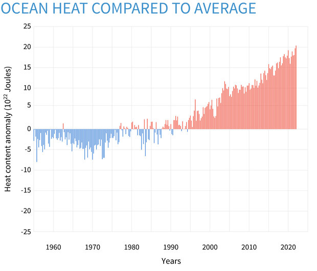
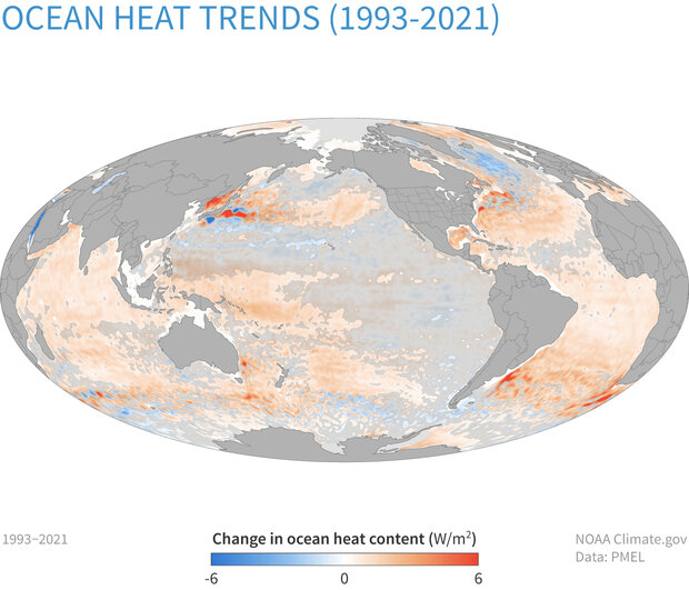
Well long post alert haha, I started with responding more about the current pattern we’re in and ended up getting into some other stuff I’ve been seeing posted about in here recently as well. Has there been much discussion about the PDO among the ones that discuss the overall pattern? Like a lot of people I’m sure, I’m of the opinion that the Pac has been in the driver’s seat the last several winters in our neck of the woods for good or for bad via the EPO/WPO/PNA. Not an expert in this realm by any means but I have been kind of considering and looking into that more as it’s likely a significant driver of the mid-latitude Pacific pattern and one that can have an effect over multiple winters. It’s shifted notably into a negative phase the last few winters, coupling with the persistent La Niña state which already implies SE ridge in the standard La-Nina pattern. Throw in the fact that SST in the Pac have been quite warm overall with respect to normal and also how warm the Gulf of Mexico and western Atlantic have been as well and it becomes somewhat obvious to a degree that “on paper” SE ridging could be a persistent problem for snow prospects on the East Coast with that combo. Specific to this winter, I also think we’ve simply been unlucky having the cold air available aside from very brief shots. Record breaking cold in Siberia and northern China during a portion of last month for example is often an indicator of the bulk of the real cold being on the other side of the hemisphere. Canada was void of anomalous cold or even normal cold to press the southeast ridge when we had a suppressed Pac jet slamming southern Cal and the SW states for the first half or so of January. To add to your point with the 2009-2015 period, comparing SST patterns to the last two truly cold winters (13-14 and 14-15) was interesting. The PDO reversed to positive during that period starting early Jan 2014. Day to day comparison 2014 vs this year 2015 vs this year Both 2014 and 2015 had the pronounced +PDO signature and both had a warm western Atlantic with 2015 looking very similar to this year being especially warm and 2014 had fairly similar SSTs in the ENSO realm. Big difference is the warm SSTs pooling along the western NAMER coast (esp 2015) in the Pac coinciding with the dominant ridging being setup in that position allowing cold air to dump into the eastern US. This year the warm SSTs are in the central Pac all the way up to the Bering Strait with cooler waters along the west coast (-PDO signature). Would seem to favor the off coast Pac ridging and western/central CONUS troughing we’ve been seeing as the dominant look so far this winter. It should be interesting to see what kind of an ENSO response we end up getting for next winter and if we continue to have a solidly -PDO. It seems our recent Nino episodes come with this index being fairly neutral or positive while Ninas couple with it being negative. Underlying factor in these SST patterns is of course that it averages a good bit warmer as a whole than 20-30+ years ago and especially so in the last 10 or so. It’s a reality on data and observations regardless of one’s view of how much CC ultimately is affecting our sensible weather in the short/intermediate timeframe. Even folks like JB, who is heavily analog driven in his forecasting approach, acknowledge this when applying older analogs to construct a forecasting idea. I saw some posting in here recently about the Ocean Heat Content, which looks like this: That’s graphing the anomaly of the oceans as a whole, while this shows specifically where heat gain/loss has been taking place in the last 30 yrs. The Atlantic and the western Pacific around Japan are the two big areas of gain in the northern hemisphere. That can ultimately have implications to our weather patterns here. How much so is the debate, there’s a lot of different variables at play even with that basic reality. I tend to agree that it’s more of a variance thing right now. In the context of a Mid-Atlantic winter I think the point some are trying to make is it’s making the difference of seeing a winter with a base crappy pattern that still delivers a couple events vs said crappy pattern not delivering anything at all…which is certainly a viable point. Of course the counterpoint to that could be when you line up a favorable pattern/setup you have a 2009-2010 or 2013-2014 type run or a Jan 2016 type one timer historic storm, and it all happens in a 5-7 year stretch like that did fairly recently. -
Central PA Winter 2022/2023
MAG5035 replied to Blizzard of 93's topic in Upstate New York/Pennsylvania
Not like we’re setting a high bar with this comparison or anything but 2019-20 was the worst and this one’s already a couple inches better than that one was here. I didn’t have a single snowfall over like 2.2” in that winter. At least this winter has some part of the subforum with some kind of “haves”, which it seems in comparison to average the UNV region has fared the best. UNV at 19.9” is only 2” below normal for the season to date. -
Central PA Winter 2022/2023
MAG5035 replied to Blizzard of 93's topic in Upstate New York/Pennsylvania
It’s looking pretty snowy over there on the 511 cams tonight speaking of which. -
Central PA Winter 2022/2023
MAG5035 replied to Blizzard of 93's topic in Upstate New York/Pennsylvania
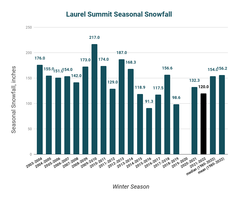
Wow I didn’t realize Syracuse was in that bad of shape. What about Watertown? I’d imagine they’re running well above normal being a SW flow recipient off of Ontario. It illustrates the lack of NW or WNW flow setups we’ve had during favorable LES periods this winter, which I’ve felt has seemed to be more of a thing the last several winters. The Laurel’s down here benefit from NW flow when it comes to LES, which I’m sure C-NY does when it comes to non or post synoptic snowfall. I did make a post about this earlier this winter but the Co-op site on Laurel Summit, near the 7 Springs resort has had one average winter since 2013-14 with the rest of them being below average. That includes 2014-2015, which was the last truly consistent cold winter we’ve had in recent winters when it came to the heart of the winter. -
Central PA Winter 2022/2023
MAG5035 replied to Blizzard of 93's topic in Upstate New York/Pennsylvania
I guess I should clarify that in no way am I “cancelling” winter or any prospective winter weather pattern beyond the next couple weeks lol. I’ll talk longer range stuff to a point but I usually focus on things inside of 2 weeks or so. I was basically saying I’m gonna call a spade a spade when it comes to an upcoming pattern that doesn’t look great which well.. it doesn’t. However, that doesn’t mean we’re going to shut the rest of the winter down… or even the rest of February for that matter. Trying to determine pattern progression beyond the operational model range (8-15 days) is never any kind of a sure thing. Which if I’m being honest, neither is the back half of the operational model range a lot of the time. Rolling with a presumed continuation of the seasonal trend (SE ridge/western trough/limited available cold) is all fun and games until it isn’t. The MJO, for example, still has to move out of Phase 3 where it’s been stalled the last several days. While most modeling progresses this into the warmer phases it’s certainly not known how much or how long it progresses into part/all of the 4-6 realm or at all.. because we’re not there yet. I consider March very much still a part of winter, some of our bigger recent snow events have come in that month such as in 2017 and 2018. Cold patterns can still be notable and have some staying power, especially during the front half of the month. -
Central PA Winter 2022/2023
MAG5035 replied to Blizzard of 93's topic in Upstate New York/Pennsylvania
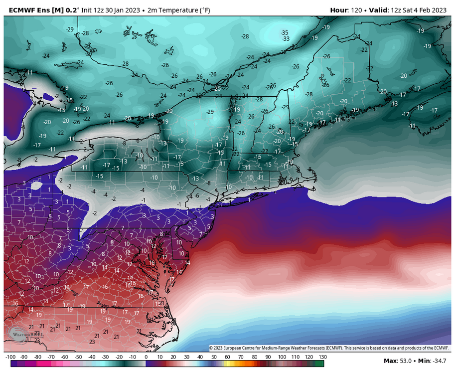
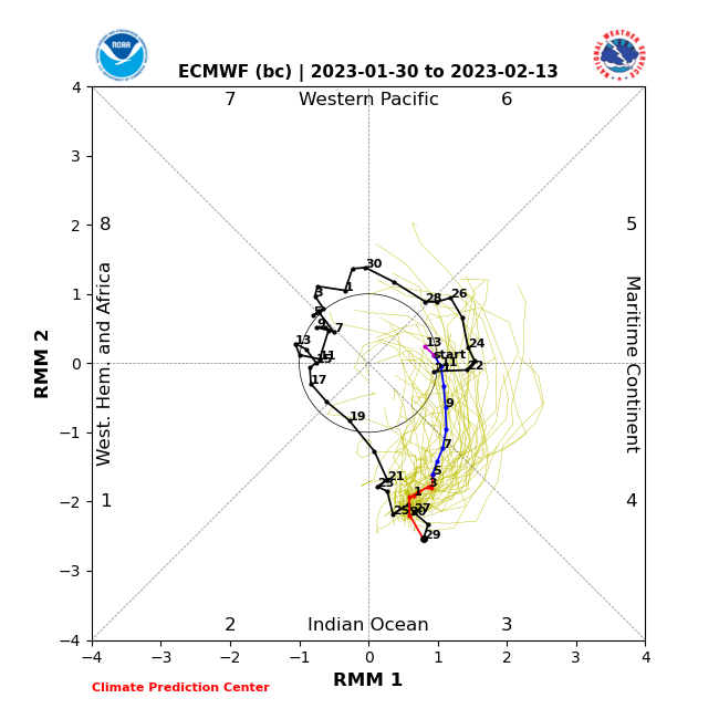
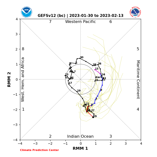
Mean 2m temps ( in ºF) for 12z Saturday via the Euro ensemble mean. The Euro suite has been the coldest guidance in terms of pressing the arctic air south, but both it and the GFS have below zero temps in northern PA and at least minus teens in that Bradford/Smethport region of northern PA, which I suppose could be considered PA’s version of Barrow, AK. Fortunately the worst of the airmass doesn’t directly target our region, and fortunate I guess if you don’t like extreme cold that we are likely to not have any kind of established snowpack of consequence. If we did have one, I could see this being the type of thing that could challenge daily record lows via ideal rad cooling. Euro tries to get NYC below zero. The fact that’s even on the table in a snowless winter to date there is pretty brutal. At any rate, this is a very brief shot that settles in 2nd half of Friday into Saturday. It’s likely to be quick enough that we’ll have non-diurnal temp rises overnight Saturday into Sunday as the glancing arctic air mass moves on. Beyond that, I really don’t have anything positive to report on the winter prospects for a period of time TBD (certainly the D8-15 range that gets into the mid-month timeframe). I mentioned a couple weeks ago the MJO was probably going to have a hand on where things go mid-late February after the end of Jan/first week or so of Feb. Since then, it finally emerged into Phase 3 where it currently resides. Forecasts had been mixed on whether the MJO pulse would fizzle there back into the null phase or go on the 4-5-6 tour and as of late it appears the latter option has become a better consensus.. certainly getting it into 4 at the very least. How fast it gets out of that realm (if it gets there) will play into any kind of attempt of a pattern reshuffle later in Feb. NCEP bias corrected guidance (GEFS) Euro bias corrected: To add to all that, we reverse the -EPO we finally got to a +EPO and run a persistent +AO/NAO and continued -PNA through the period. The former (NAO/AO) retracts true arctic air poleward and the latter (PNA) implies continued western troughing. It looks like a lot more of a traditional +EPO Nina setup. I’m never gonna say winter’s over on Jan 30 but I’m not going to pull any punches when I see a period I think has a high chance of sucking either. Really needed this weeks active southern branch pattern with available cold to produce… which I mean still could to a degree I guess if we can somehow get a piece of something into southern PA. I honestly like the DC folks’ chances better to score something provided they have cold enough temps to snow. Either way, I don’t see anything in the caliber that this setup COULD have produced for our region.. just no interaction between northern and southern branch. -
Central PA Winter 2022/2023
MAG5035 replied to Blizzard of 93's topic in Upstate New York/Pennsylvania
Another week of wasted opportunities seems to be in the offing this week as we eventually settle into a seasonably cold regime this week after the weak system today into Monday. Split flow with an active southern stream should be a recipe for some success with some cold available for a change but models have been generally insistent on not even partially phasing anything enough to bring precip into our region and keeping these southern stream systems in pieces and disorganized. I do think that Feb 2-4 period still has the best chance at maybe getting something up here with that particular wave. Lost in the spring fling in here and what may squash that particular wave is a very brief but significant arctic shot on the models next weekend that glances C-PA but targets the interior northeast directly with some -30ºF and less ACTUAL temps Sat morning in far northern Upstate NY and interior New England. Euro is a bit more widespread into PA with the arctic air and barely gets much of PA into the teens during the Saturday. GFS is warmer but still much chillier than what CTP has in their grids. Both have below zero temps to start Saturday in at least the northern half of PA. I’d imagine they may want to consider bumping down temps in their grids in that parcticular time period. -
Central PA Winter 2022/2023
MAG5035 replied to Blizzard of 93's topic in Upstate New York/Pennsylvania
Have about an inch of new snow so far this evening from the LES/upslope snows and occasional bands that have had success getting off the Laurel’s tonight.




NationalCentersforEnvironmentalInformation(NCEI).thumb.png.72fcdda97908427d0a57a528358d71c7.png)
