MAG5035
-
Posts
5,882 -
Joined
-
Last visited
Content Type
Profiles
Blogs
Forums
American Weather
Media Demo
Store
Gallery
Everything posted by MAG5035
-
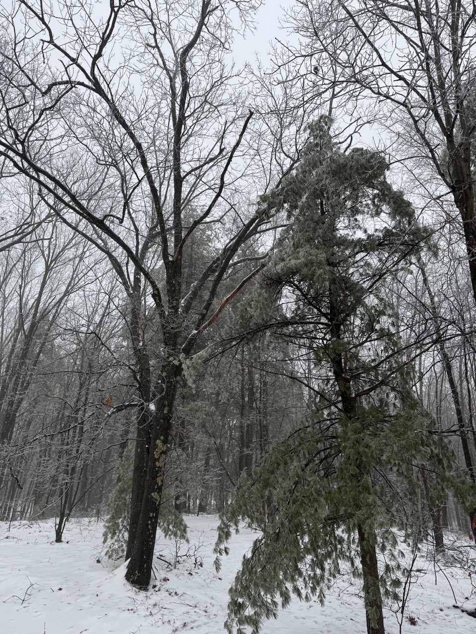
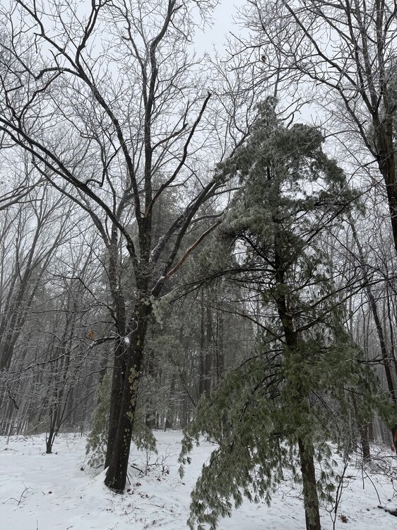
We might not be a snowtown but we do ice like no other haha. Still around freezing. This is my parents place a few miles up the road in Bellwood
-
Here’s my take on next week’s system. I’m seeing a problem of amplification out west right now. If you’re gonna throw in classic big east coast storm comparisons like a Jan 96 et al you better have a good western ridge set. What I’m seeing in the progs today is there’s shortwave coming ashore on the west coast that seems like its dampening/pushing the ridging that pops up before it ever really builds to allow that 500mb shortwave in the northern plains to drop in and bring the coastal up. So instead the southern feature goes out ahead and elongates the whole thing and doesn’t allow that coastal to turn the whole way up. I think the eventual handling/interaction of that shortwave that comes into the west while all the rest of this is coming out on playing field is going play a big part on whether this comes fully back to a big threat or not. Or.. if some part of the Mid-Atlantic piles more snow up below us. But, if the coastal does end up going wagons south and east with the primary coastal in the end… I do still think a widespread lighter to perhaps even moderate snowfall in places is quite possible in PA from the upper feature, as it’s a pretty strong 500mb low that tracks over the state and there will still likely be some kind of interaction with the southern feature in that scenario. So while I’m fairly pessimistic about scoring the big hitter at the moment I’m definitely not thinking this is a complete non-event.
-
Been pretty busy today. 2.4” (tied for second biggest snowfall this winter lol) was my total snowfall this morning and it’s been occasional freezing rain/drizzle since. Still at 31.6ºF and still actively icing on the trees and the driveway with the next batch of rain coming in. Don’t expect much movement in temp here until the mid-morning most likely.
-
The one Euro thing that isn’t on board for next week currently is the EuroGPT. That thing’s been even more of a whiff than the GFS the last couple runs.
-
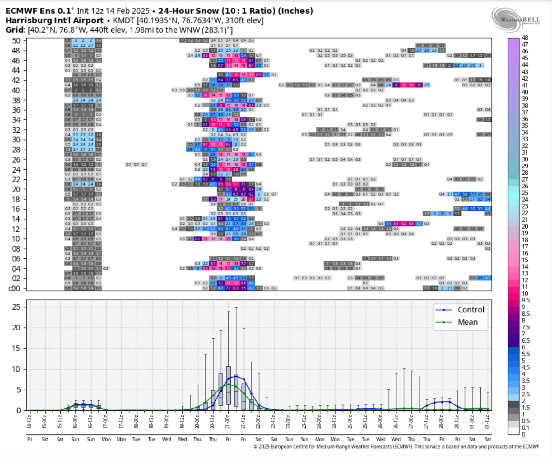
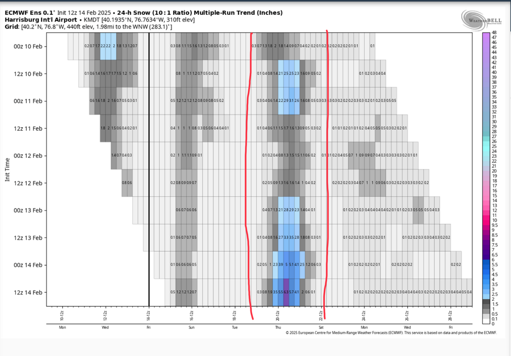
It’s still a really solid signal from the ensemble at this range as it has like 30 members with a warning snowfall and the vast majority with an advisory event. Although the Euro is by far the best ensemble at the moment compared to the GEFS and Canadian ensemble. Here is it’s multi-run snowfall mean trend the last 4 days. It’s definitely trending in the good direction currently.
-
Here was MDT’s plume from the 12z Euro ensemble. About 18/51 with a double digit snowfall.

-
Canadian’s coming in looking way better as well. Good start to the 0z suite. Been waiting to see how things respond as sometimes these storms kind of go away in the models during this particular range. The ingredients are going to be there for a big storm if we can amp and phase it in time to turn it up the coast.
-
In the middle of quite the snow band right now. Haven’t been out to measure yet but looks like around an inch.
-
We did actually end up with a fresh half inch of snow early this morning, which brought the running total up to a crippling 1.1” haha. 30/27ºF currently awaiting the messy part of this overall event to arrive later.
-
Only 0.6” here today, a decided underachiever even being positioned on the fringe of this event. Still need 11” of snow just to reach last year’s lackluster season total. One of these bigger events needs to get us at some point.
-
I’m up at Blue Knob currently, the snow started a bit after noon up here. Looks like about an inch so far. Judging off the cameras looked like some kind of coating to perhaps a half inch at the house.
-
Boy things have sure escalated the last few runs in terms of the medium-longer range. It appears we transition into a pattern next week more favorable for traditional amplification and the overnight runs have definitely obliged on that front with the big storm being progged D8-10 on both Euro and GFS as well as some ensemble support. That’s when the MJO is forecast to be running in 8 by that point, coupled with the PNA forecast to transition to postive and the NAO transitioning from deep negative toward neutral. Definitely a period of interest for sure. Working backwards, the weekend system is trending towards somewhat more interesting. Models seem to be starting to respond toward the fact there is a pretty significantly negative NAO block ongoing and have thus started forcing that deeper low more SE towards the coast instead of a straight lakes cutter. GFS/Euro have actually been taking the low to the coast along or under the M/D line, with the GFS being the colder scenario. Either way, that storm might not be the straight forward brief mix to rain scenario it had been looking like. Lastly, we still seem set for today.. least in terms of what I was thinking for accums. No real changes on those thoughts.. which was basically not much above I-80, 1-2” between I-80 and the turnpike, and 2-4” turnpike south..with near the M/D line maybe seeing a couple 5” amounts. One thing I’ve been watching is some guidance has been getting the snow up into the central counties a bit further in latitude.. so AOO-UNV corridor could possibly get into a lower advisory amount type scenario. We shall see. Tomorrow’s mix scenario that may start as more snow is still there but QPF has been kind of lacking with that lately. It will likely need another advisory for most in here for at least T ice expected and maybe an inch or two of snow for some.
-
I haven’t really posted much lately on the next two events but the evolution of this becoming almost essentially a single two pronged event of sorts between Tuesday and then the system that tries to cut later Wednesday is a detriment to the Tuesday one being the widespread bigger C-PA snow event it otherwise could be… as the system that makes Tuesday’s event ejects out weaker and the energy left for Wed-Thurs one digs. There’s still plenty of moisture for Tuesday, just on a fast W-E flow. So while I can’t rule out a bump north in the next 24hrs, I’m not really expecting more significant accums to get above about the turnpike or so. IMO, this is looking like a 1-2” between the turnpike and 80 and advisory (2-4” perhaps some 5 on the M/D) in the southern tier of counties centered on the turnpike. Better snows south and not much once above 80. That leaves the Wed-Thur system quick on this one’s heels that is going to try to cut into a fairly well positioned Canadian high. Given the reinforcing high and also how quick on the heels this is of something that presumably would have just dropped a good swath of snows centered on the DC/NOVA folks, this has a good chance of running a wave of front end snows much further up into eastern and central PA before any mixing. Especially if the precip gets its act together more quickly.. like the RGEM and GFS has for example. There may not really be much of a lull between these systems in the end.
-
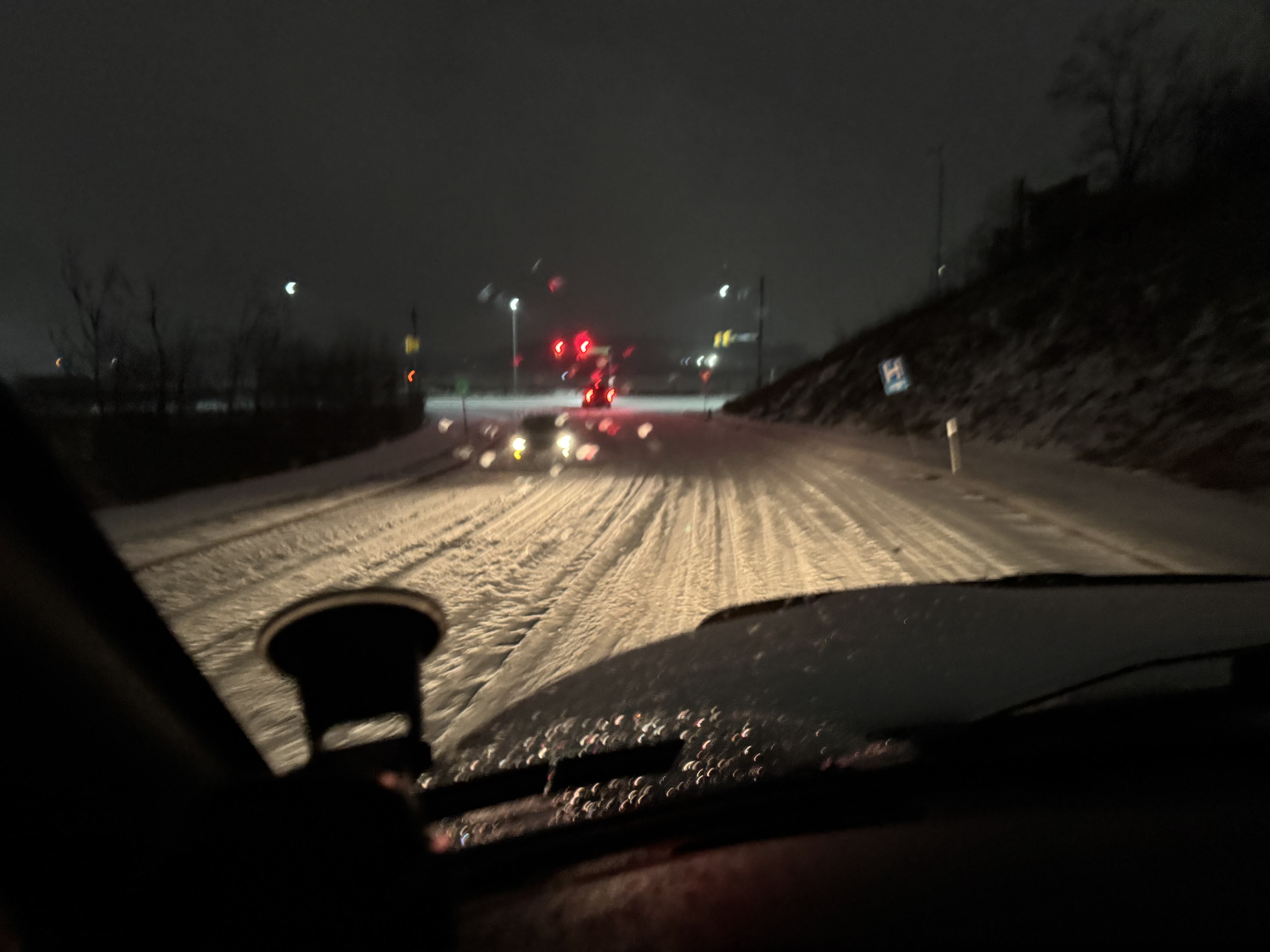
Here’s what the roads looked like a bit ago, that’s entirely sleet. Things are getting plowed off now but there’s been more freezing rain in the mix. Still about 30.

-
Measured roughly 1.3” of pure pingers so far. The pellets are really fine so it makes walking on it like walking on the beach.
-
It’s been sleeting so hard we’re already getting close to as much as we had on the ground Wed Night for the whole event, which was about an inch.
-

-
Thunder sleet, again.
-
The first small wave of precip has arrived here as a pretty decent burst of sleet, already whitening things. 28/25ºF
-
I had about an inch of sleet and some minor freezing rain accumulation this morning to go with what ended up being 4 lightning strikes I saw between 4-5am this morning. I dunno if I’ve had that much thunder and lightning during the whole late summer and fall lol. Mixed out here around 2 or so and went from 34 to 48 in about 35 minutes, so a pretty good meltdown ensuing and quite windy.
-
28ºF and mostly heavy sleet now, with a bit of freezing rain in the mix as well. I’ve seen three lightning strikes.
-
Officially thunder pingers here with that line coming overhead. Nice lightning strike.
-
28ºF/23ºF and a steady freezing drizzle has commenced here in the last 20 minutes. Already icing over everything.
-
The thing with this pattern coming up in this timeframe is it’s likely that kind of a monster swath of snow is going to materialize in some form in the aggregate sense. Perhaps not as wide, but there’s going to be a swath of big winners from this pattern. Overall as I mentioned a couple days I think it’ll be an upstate NY and New England being the biggest beneficiaries, as they’re also going to total decent snows from tonight and Saturday’s event. That doesn’t mean we can’t score a decent snow event or two. The big driver in northern PA’s big totals on the 12z Euro (about 30” of it) mostly came from the modeled long duration event that was way out in like D12 or so. To answer your question, the last time northern PA had a swath like that was the December 2020 storm. That had a band of 2-3+ feet of snow up there, including Emporium over to Renovo and on northeast. I do believe it was also the original wsptwx’s biggest ever snowstorm as well. I think our best opportunity to score a decent area wide snow event that has limited or no mixing is going to come from the thing that’s progged near mid week next week. And there’s a lot to resolve with that, but that seems like the timeframe that lines up with the boundary perhaps being low enough. Beyond I don’t quite think the pattern is going to go really cold yet and we’re going to continue to ride the line. We’re in phase 6 of the MJO right now and models are varying with the speed at which that moves into 7 and eventually the colder phases. We also have some mixed teleconnection signals coming up while we otherwise maintain -NAO/AO and have AK ridging. We’re lucky we’re in the game given the phase 6 MJO, that’s traditionally the torchiest of the torchy phases in JFM. I do still think the eventual end game this month is it will get quite cold with respect to average, but that may be more during the second half of the month.
-
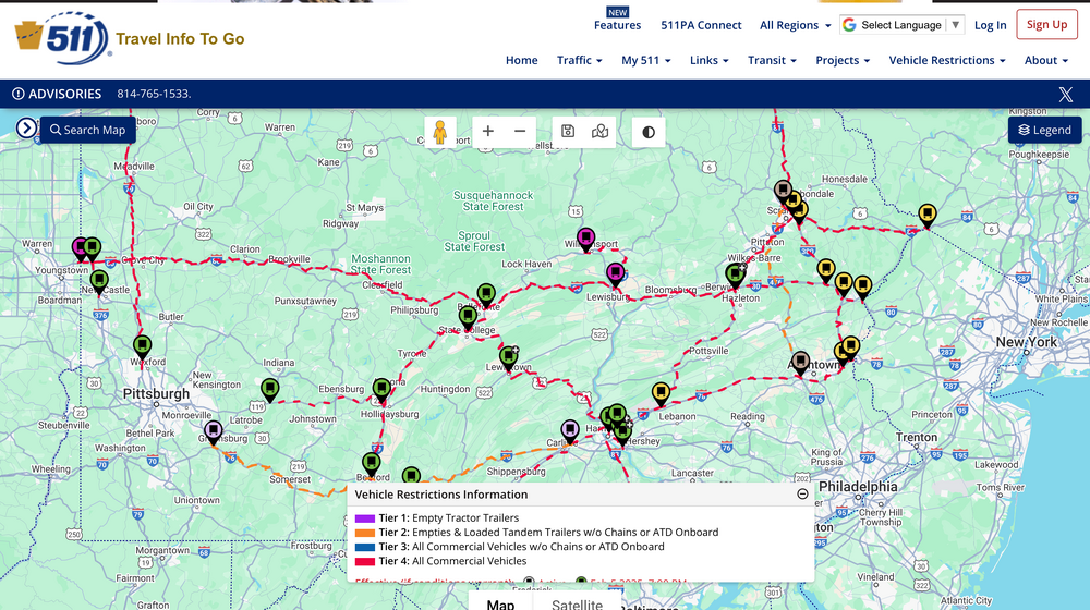
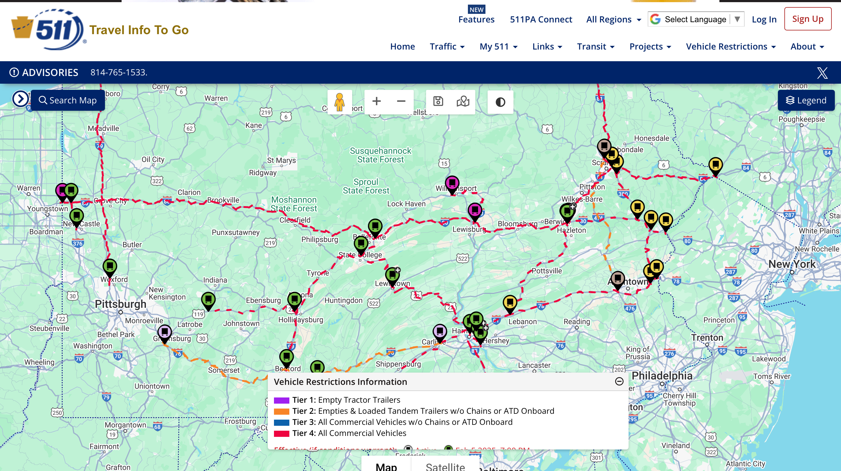
PennDOT not messing around when it comes to scheduled tier restrictions tomorrow night. Most major routes are tier 4, basically restricting everything except passenger cars/trucks and emergency vehicles.