MAG5035
-
Posts
5,882 -
Joined
-
Last visited
Content Type
Profiles
Blogs
Forums
American Weather
Media Demo
Store
Gallery
Everything posted by MAG5035
-
Starting to ping, I’m at 3.8”. Right around 32ºF
-
And the overnight Euro looked rather solid for the 16th. It has a more pronounced and much better placed western ridge… pretty much where you’d want to see it for C-PA. The GFS this morning is getting better too (a little west with the ridge axis). If we’re going to see a legit East Coast snow storm (something perhaps of the KU variety), that’s going to be a feature to watch if we start seeing more solutions like the Euro showed overnight. This is the period where we start to match up teleconnections… PNA to neutral or somewhat positive, NAO/AO/EPO negative, WPO diving negative.
-
I’m at 3” now. I measured 1.3” 30 minutes ago. Big loud flakes falling now.
-
I might need one for this one, lol.
-
Just woke up, and there’s already 1.5” of new snow on the ground and it’s snowing every bit as hard as it was Saturday. Wow.
-
We’ll see, there’s a lot of lead time yet for that system to see where the large scale features end up being positioned. That system should have plenty of cold air to work with, so if it can stay under PA and along the coast there is a better chance for more frozen precip to be favored. But yea, it’s definitely a bummer to mostly waste a really active period this coming week with tomorrow and then likely on Saturday.
-
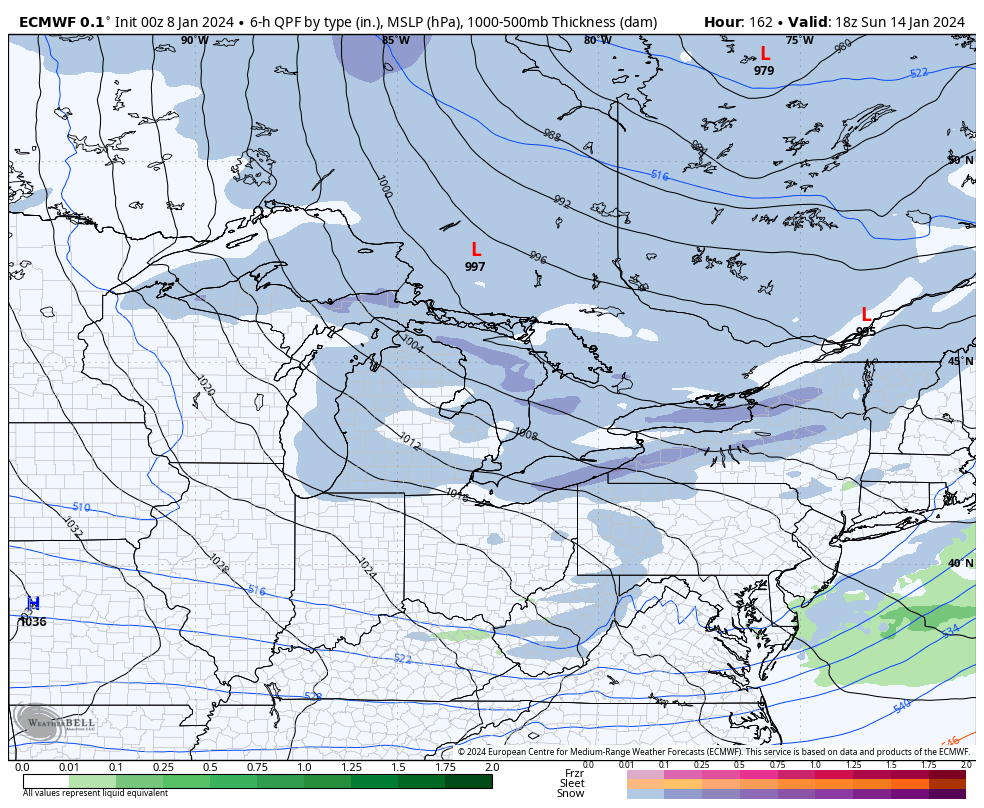
I think the event being progged around the 16th has a decent shot of being something in the snow dept. The weekend system looks a lot like this one coming tomorrow, cutting to the lower lakes… with maybe some front end. That’s going to be the first system that starts bringing actual cold towards the east in its wake. Probably the coldest of the season to date, which isn’t really saying much. But that deep low hits the high latitude blocking and the 16th system coming fast in its wake is going to get forced under more. The difference with that system is the developing negative EPO/WPO regime AND a neutralizing PNA as there’s finally a bit of ridging that moves to the west coast. That’s going to push some of that arctic cold that originally dumps central/west this week to the east and theoretically.. the storm boundary. Only caveat I see in the early going is that western ridge axis as progged would be a bit too far west for what we normally would want to see. But there’s at least some semblance of it and combined with the -NAO/AO and -EPO/WPO will eventually push the cold east. Next week looks like it could be a legit below average week temp wise… especially after whatever that 16th system does. I’ve been to Nashville several times but that’d be a fun place to go to an NFL game. And I think Nashville is also planning to eventually a build a new stadium further outside of downtown. I think it’s great as is, where you can walk from all the bars and such downtown across the bridge to the stadium. I haven’t been to a Steelers game since the 2011 AFC Championship game.. it was about 10ºF at kickoff for that one.
-
That’s pretty wild, to go along with that they also mentioned record high integrated water vapor transport (vs climo) sourced from the Gulf and Atlantic. Might as well call that the east coast version of an atmospheric river. They did further on the wind threat, their reasoning highlighted below is primarily why I’m pumping the brakes some on excessive winds at the surface in the Sus Valley. If there in fact a squall line that develops with the front to our south, it’ll have to be watched to see if it gets into the southern LSV. By the way, great discos by LWX and CTP this morning. LWX
-
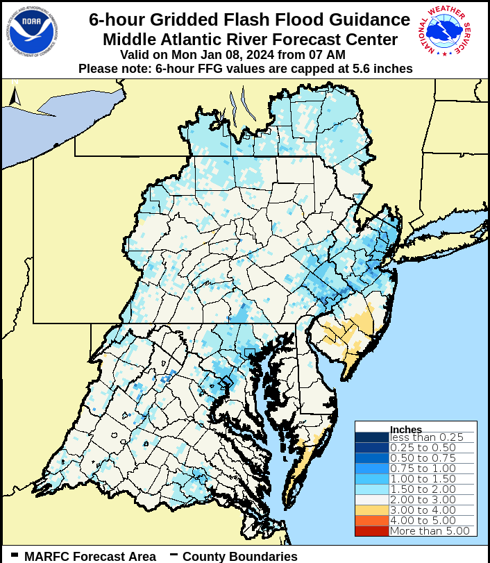
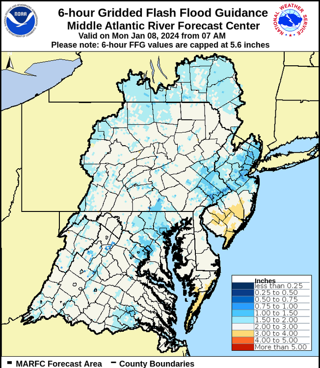
My latest thoughts on tomorrow’s triple threat. Still trying to gauge the wind threat in the Sus Valley. CTP has a nice write up in their AFD this morning laying out their thoughts on it and the system as a whole. I personally think the threat of big winds (gusts in excess of 50-55mph) are going to be confined in that few hour period prior to and during the frontal passage.. where the Sus Valley may get into the warm sector and mix better gusts down. Don’t get me wrong it’ll be windy, but I dunno about excessive winds. That’s a different story in the coastal plain region and along the coastline. They did issue high wind watches in the Laurels, where the elevations will poke into some of that crazy low level jet. PIT also issued them on their side of the Laurel’s.. as this is one of those less common setups where downsloping winds are off the Pittsburgh facing front of the Alleghenies with the SE flow prior to FROPA. As for the behind the system I’m not super impressed with the winds other than the typical 30-40 gusts. We don’t really get a rapid pressure rise behind the front with this. Moving on, the biggest threat by far is becoming the flood threat, which I think was already the biggest potential issue at hand with this system here. MARFC flood products today really show the vulnerability with the widespread 1.5”-3” of QPF expected. Additionally with the QPF forecasts.. a quick study of the waterways on MARFC’s headwater guidance show moderate flood stage pretty easily attainable across the board in the Sus Valley and Juniata basin waterways. 6 hr and 12hr numbers don’t differ very much either. On top of that, there’s roughly about 0.5-1.0” locked up in the snow on the ground as of this morning over a big part of C-PA. There’s definitely going to be issues that are likely going to be a more than the standard small streams/poor drainage variety with all that. And lastly, which will be firstly in terms of weather impacts.. we have the front end snow potential deeper in central PA, where AOO-UNV up into the north-central may well see advisory amounts in the morning/early afternoon before it changes to rain. This could in fact come down nearly as hard as it did on Saturday, which would make a mess of things on the roads first half of the day. Then all the rain on top, which could still be at least 1-1.5” if 0.5” gets put down as snow/mix.
-
Any snow weenie Steeler fans up for a snow chase/ playoff game could get a two for 1 special in Orchard Park this Sunday.

-
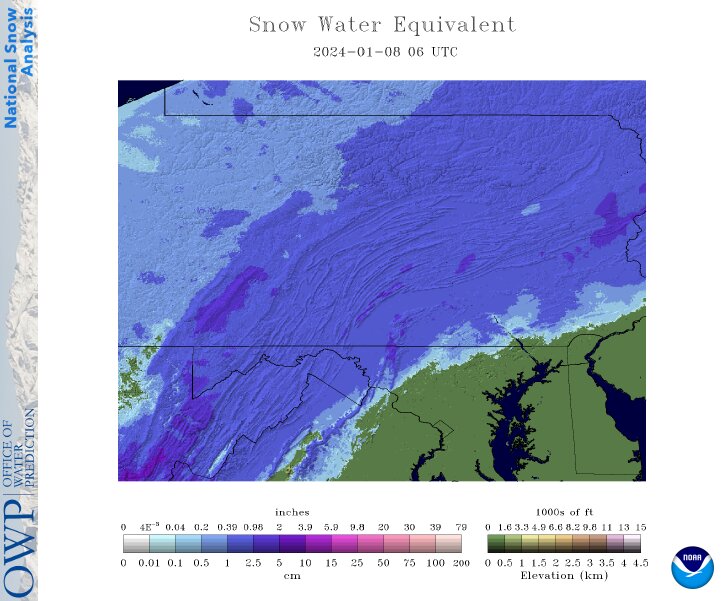
The flood threat’s there for sure, with modeling and ensembles across the board indicative of 1.5-2+” of QPF across all of C-PA and the Sus valley. Sus Valley and SE PA would be the primary focus area for flooding in PA, where recent antecedent conditions are already fairly wet and temps will have the biggest surge ahead of the frontal passage and expedite melting of whatever snow has fallen to go with the significant rain. York/Lancaster look to be in WPC’s “slight risk” for excessive rainfall while about the eastern half or so of PA is in the “marginal”. Wind is another story. Despite the extremely impressive low level southerly jet, cold/cool air damming and steady moderate/heavy rain is likely going to provide a stable boundary layer most everywhere east of the Laurels for at least a good portion of the pre frontal passage portion of the event. Those screaming winds won’t mix down with that. I think for the Sus valley any wind issues that become more than the typical “breezy”variety (maybe some 30-35 gusts) is going to heavily depend on busting into the warm sector. That provides the means to mix higher winds to the ground and a line of showers/storms associated with FROPA would definitely have the potential to bring damaging winds. CTP talked winds in their AFD and only really discussed potential high wind watch for the Laurel’s for now.. where elevation (higher elevations near the 925mb layer) would catch the higher gusts from the southerly jet. Their confidence on 50kt gusts to necessitate a high wind warning in C-PA is low right now. The really serious winds are more likely along the coastal plain and coastal areas up the eastern seaboard from the Mid-Atlantic up into New England. Modeled winds on the backside of the system aren’t super impressive, def breezy (30-45 gusts) but not sure about headline worthy.. at least in terms of the high wind warning variety. Lastly there is a winter weather impact aspect to this too. Not for the majority of the sub-forum demographic, but in the interior counties of central PA. Most guidance has been pretty firm on a period of accumulating snow/sleet in the AOO/UNV/north central PA realm, turning to a mix/ZR and then rain. NAM was warmer aloft but still has a several hour period of mixed precip (more ZR dominant). Either way, I expect advisories to be needed for the aforementioned portion of C-PA. CTP disco
-
I don’t have any special back channels to talk to any CTP mets unfortunately, other than just giving them a call. However, overnight CTP put a PNS out acknowledging the end of the snow drought at Harrisburg International and put out a snow total of 3.3” for yesterday from them. I’m sure it just came down to reporting times for their obs/climo like MGorse said but I’d like to think you broke into the airport property and took your own measurement lol.
-
Been pretty much done with the heavier stuff back this way for the last couple hours, but have transitioned to freezing drizzle and some occasional pingers. Still just a hair under 28ºF. 6.2” was my reported total snowfall.
-
There’s some pingers being observed on mPing near Clearville and Breezewood (Bedford Co) with that band of really heavy echoes moving into Fulton/Franklin/Southern Huntingdon. Might be indicative of a surge of mixed precip that gets deeper into the Sus Valley (perhaps catching Carlisle/Harrisburg or so) as we get late in the event. Yea this was a nice event. We’ll have to see if we can keep some lighter snows going for a couple hours longer.
-
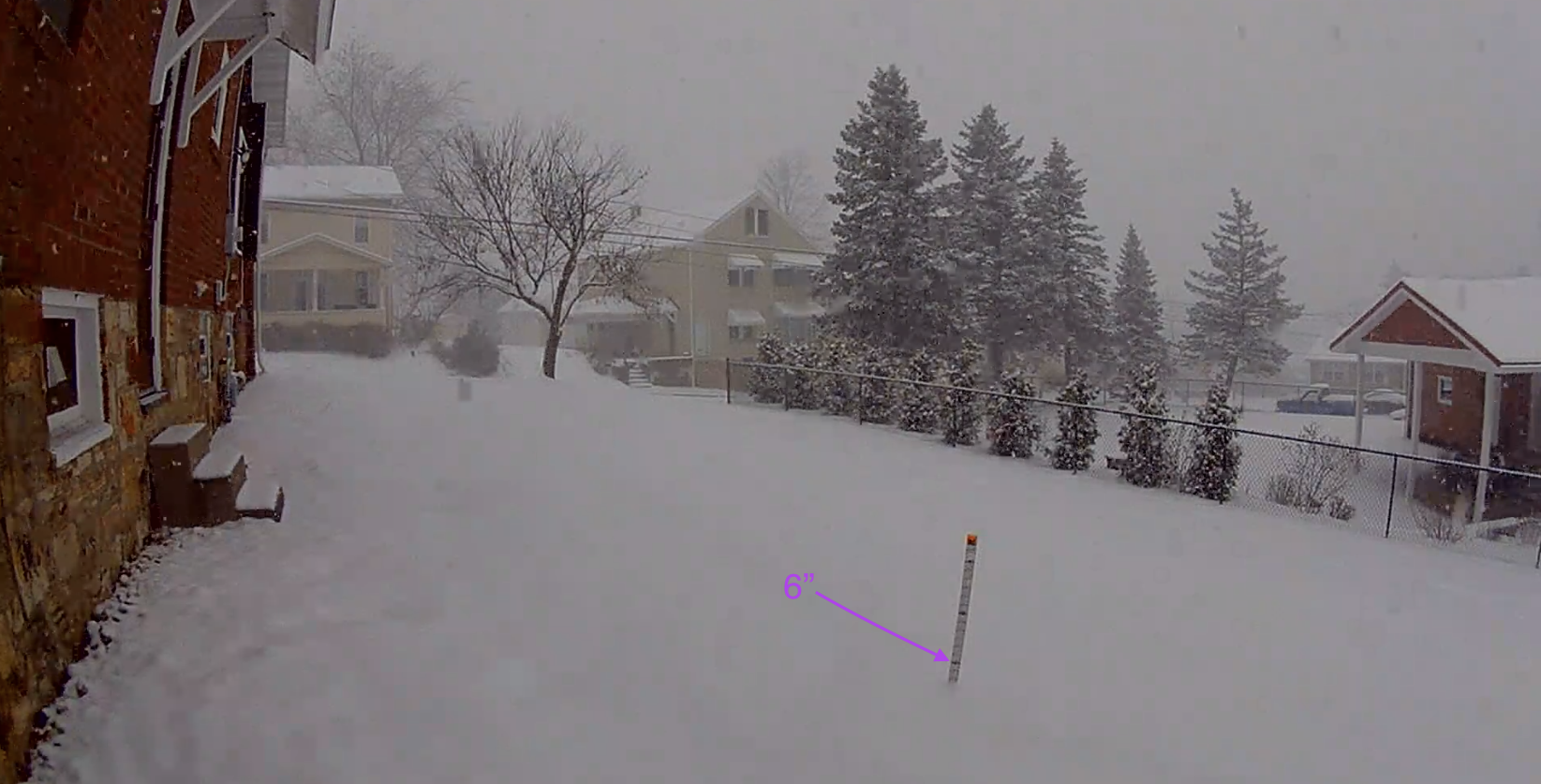
4pm obs: Moderate snow and 27ºF. Right at the 6” mark (1.2” last hour) so that makes it the first warning event here since at least the 21-22 season. Back edge of the good stuff is lurking pretty close to here, gonna have to see if anything tries to backfill a bit the next couple hours.
-
3pm obs: 27ºF and moderate-heavy snow. 4.8” on the ground making 2.3” (!) in the last hour.
-
Closing in quickly

-
2pm obs, 2.5” on the ground (1.2” the last hour) and it absolutely pouring snow right now under this heavy band.
-
Intense band shaping up to come through here soon. It’s already been snowing at decent rates.
-
1.3” on the ground with moderate to heavy rates, powdery. Temp down to 26ºF
-
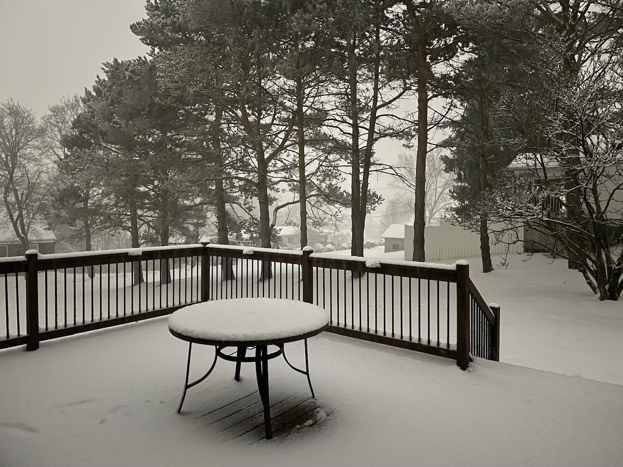
Was out for a couple last min things when the snow started around 11am. Most roads quickly showed varying signs of caving. Moderate rates right now with a coating. 27/24.5ºF.
-
25.5/20ºF and cloudy here. Snowboard deployed.
-
Those TT maps count all winter types as snow on it’s 10-1 map, I usually warn about it at least once a winter or so haha. The NAM was a bit better in the LSV though. There was a better thump in front of the mixing. Sus Valley was similar on the 10-1, while the central areas getting 10”+ on Kuch are doing better than 10-1 ratios to get it. 12z v 6z
-
The upcoming 7 days or so are going to be a bit rough other than for this storm chance. Temps are going to be a bit above average along with the big time cutter. Significant cold in Canada dumps in the west at first with the -PNA so we’re looking at a cold west and warmer east. Getting toward week 2 we develop a -EPO/WPO to go along with the already negative NAO/AO. That should allow the cold to push east in time. It is definitely a nice look, though a wildcard in there is the MJO and what that does. Models eventually have it running through 4-6 at differing degrees of magnitude.
-
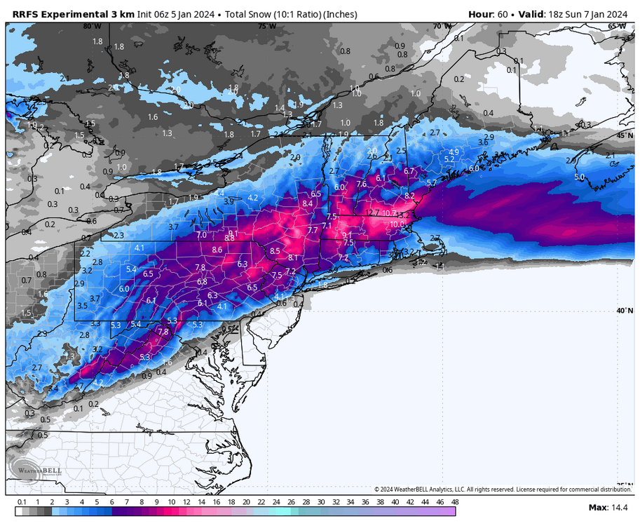
Might as well throw up the 6z run of the experimental RRFS (Rapid Refresh Forecast System) too. It’s a little bit colder aloft which makes a big difference in the LSV. 10:1 map, there’s no Kuchera one available for this. And if your wondering what RRFS is: