BooneWX
-
Posts
2,381 -
Joined
-
Last visited
Content Type
Profiles
Blogs
Forums
American Weather
Media Demo
Store
Gallery
Everything posted by BooneWX
-
The torch in December also wasn’t as torchy as we thought it’d be. A couple well above average days but mostly muted by endless rainstorms - which, looks exactly like the upcoming pattern.
-

2023-2024 Fall/Winter Mountain Thread
BooneWX replied to The Alchemist's topic in Southeastern States
Flow still flowing? -
My suspicion is a bit of Downsloping because my wind has been more westerly than northwesterly. I’ll be curious to see where we max because I’m hard pressed to believe it stays under freezing now but maybe.
-
Low of 19. Very unimpressive “arctic blast”
-
Amen. But that’s what makes them all the more rewarding to net. That’s by far my favorite fish to catch on a fly. A big brown and a smallmouth are close behind though.
-
Love it! We’re on the north side of lake hickory. For years I had grown to hate summers and then boating completely changed it. Fell back in love with that stretch of the year and even the heat to a degree. Access to water recreation really does make or break summers in the south imo.
-
So what activities do you guys like to do in the spring?
-
Radar returns around Surry look good. Hang in there! I’d think Fancy Gap to Doughton Park is getting smoked right now.
-
2023-2024 Fall/Winter Mountain Thread
BooneWX replied to The Alchemist's topic in Southeastern States
It’s not sticking but it is laying it down here in Caldwell County -
Two snow showers the last 30 min
-
Well. At least I can say I saw snow twice this week
-
2023-2024 Fall/Winter Mountain Thread
BooneWX replied to The Alchemist's topic in Southeastern States
I know you guys are getting absolutely smoked because from the foothills it’s an absolute death wall of white towering into the atmosphere -
2023-2024 Fall/Winter Mountain Thread
BooneWX replied to The Alchemist's topic in Southeastern States
Radar looks juicy. Enjoy! -
GSP disco says containment breaking will happen this afternoon. They even go as far as saying a dusting is possible in non-TN border counties
-
Southeast Sanitarium - Winter 23/24 Edition
BooneWX replied to eyewall's topic in Southeastern States
Yep! I always gauge it by the lack of traffic in the mid-long range disco and if I didn’t know any better, I’d think it’s mid July on this forum. -

-
Ice everywhere and several wrecks in Caldwell County. Rained in the mid 30s last night but almost everywhere in the county dipped into the upper 20s by sunrise.
-
Feeling more confident that whatever falls here may be freezing rain or sleet. My temp is down to 36, DP of 19. Wet bulb of 30.6.
-
Sometimes you just need a Hail Mary!

-
we don’t thank you enough for your contributions to the group
-
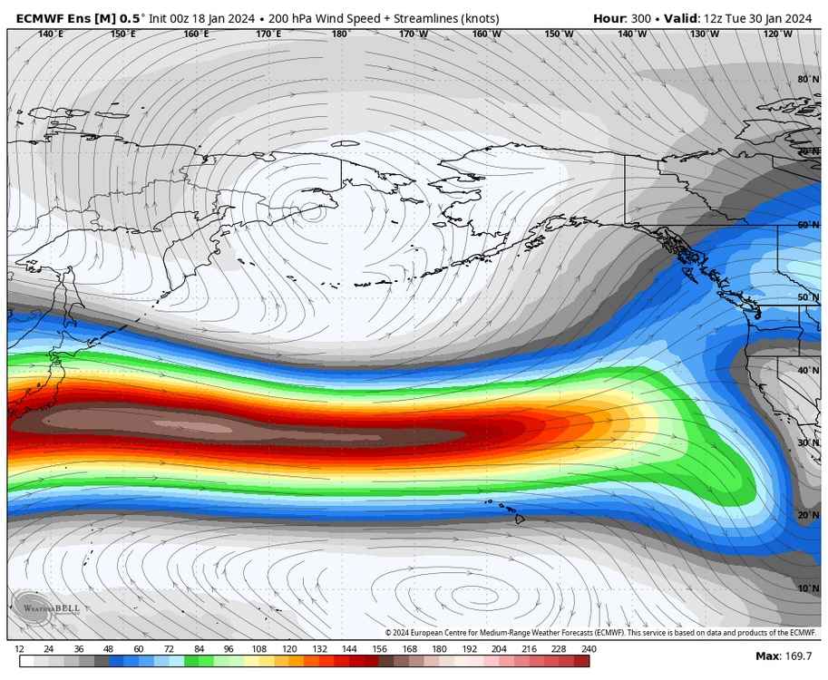
I’m taking anything past 100 hrs with a grain of salt but IF this Pacific jet comes to fruition, we will burn weeks trying to break it down
-
Oh boy. That pacific jet could be raging. What’s the saying? What happens in December the winter will remember?

-
2023-2024 Fall/Winter Mountain Thread
BooneWX replied to The Alchemist's topic in Southeastern States
GSP says ratios for the mountains could be 20:1 . Good luck everyone! I say @Bucketheadgets another foot. -
I’m not going to sweat weeklies or any model run past 5 days. The models haven’t even been in the ballpark at 100 hrs this winter, so there’s no need to think about a forecast that’s 13+ days out.
-
hope you’re doing well Frosty!