-
Posts
1,134 -
Joined
-
Last visited
Content Type
Profiles
Blogs
Forums
American Weather
Media Demo
Store
Gallery
Everything posted by BlunderStorm
-
Absolutely beautiful outside right now. A snow squall is passing over with bursts of 2-3 in. an hour rates. Some of the snow is coming down over an inch in diameter. I finally got my share haha. Since it's arrival the temperature has dropped a whole 5 degrees from 32 to 27! UPDATE 1: Temperatures have risen back to 29 but it is still snowing at a light to moderate rate. Soon, I will take a measurement once this period of snow ends. UPDATE 2: Another smaller snow squall is currently (1:14 ) passing over with more heavy rates. UPDATE 3: A good 1.3 inches of snow IMBY fell in the last hour and a half. A few snow showers may follow after but this looks to be the end of the snow squalls.
- 355 replies
-
- 2
-

-

-
- observations
- measurements
- (and 15 more)
-
I've managed to dodge most bands of snow but I'm not complaining. I hope your getting hammered over there John.
- 355 replies
-
- observations
- measurements
- (and 15 more)
-

Education and Questions/Discussion Regarding Weather Features
BlunderStorm replied to EastKnox's topic in Tennessee Valley
Thank you for the explanation. I had a partial understanding before this just picking up on things but this really cleared things up. -
It's very hard to pin down but I think I will mark Tuesday as having 0.2 in. Temperatures have gradually cooled and it is now 30. Some increased snow shower activity to the WNW of me is making it over Big A Mountain surviving the downslope.
- 355 replies
-
- observations
- measurements
- (and 15 more)
-

Winter 'Tis the Season Banter Thread 2018-2019
BlunderStorm replied to Carvers Gap's topic in Tennessee Valley
It takes a yard of snow on the ground to entirely stop my desire for more. And also... ICON -
Snow is coming down at a moderate rate and the ground is turning white. Currently 32.
- 355 replies
-
- 2
-

-
- observations
- measurements
- (and 15 more)
-
This morning we've had a few intermittent bursts of snow. It's 33 but that hasn't stopped a light dusting from accumulating.
- 355 replies
-
- 1
-

-
- observations
- measurements
- (and 15 more)
-
I'm keeping a sharp eye out for flurries tonight. If there is as much as flurry for a brief minute I want to make sure I mark that day down for a trace especially before midnight. As of now still a tad too warm at 36. UPDATE: and... just 20 mins later boom flurries falling yahoo!
- 355 replies
-
- observations
- measurements
- (and 15 more)
-

Education and Questions/Discussion Regarding Weather Features
BlunderStorm replied to EastKnox's topic in Tennessee Valley
So essentially the source for our cold is limited and the low in some runs is shown as being too strong. In other words we have a juggling act. The drop in annual snowfall for Knoxville in the past 40 years was really eye opening, thanks for that tidbit of info. -

Education and Questions/Discussion Regarding Weather Features
BlunderStorm replied to EastKnox's topic in Tennessee Valley
Regarding this weekends storm system. I understand the high in the midwest is crucial to CAA resulting in snow as the low supporting precipitation slides under it. However as pressure rises precipitation is less encouraged and is generally lighter. On the 12z GFS the storm was suppressed to the south resulting in no snow at all here. On the other hand for the 18z GFS the high pressure was weakened and as a result I was projected with precipitation except the temperatures were too mild to support snowfall for a majority of the storm. So in a nutshell what I'm saying is how do you get the cold and the moisture together dang it?! -

Winter 'Tis the Season Banter Thread 2018-2019
BlunderStorm replied to Carvers Gap's topic in Tennessee Valley
Not from Mid-Tennessee either but welcome to the Tennessee Valley! Here is some climate information for Clarksville, TN. https://www.weather-us.com/en/tennessee-usa/clarksville-climate -

Winter 'Tis the Season Banter Thread 2018-2019
BlunderStorm replied to Carvers Gap's topic in Tennessee Valley
I don't care what anyone says last year was a white Christmas! Sure it may have only been a light dusting... but who cares SNOW! -
Today's high was 66. As of now it is 59 with sustained 10 mph winds from the southwest.
- 355 replies
-
- observations
- measurements
- (and 15 more)
-
For the first time in a few weeks it's reached 60 today thanks to some breaks in the clouds. I can always appreciate a warm reprieve after a long period of cold.
- 355 replies
-
- observations
- measurements
- (and 15 more)
-
I figured since meteorological winter was just around the corner I'd go ahead and get the new observations topic ready. Let the season begin!
- 355 replies
-
- 2
-

-

-
- observations
- measurements
- (and 15 more)
-
Lacking extensive knowledge of the effects of SSTs in different parts of the oceans and how they affect our weather patterns is a part of the reason you see little traffic in this thread. I can easily give observations, dish out banter and fantasy storms, and even give a rudimentary opinion as to what to expect a few weeks in advance, but beyond that I feel I cannot create a coherent post of value in this thread so I sit in the background instead attempting to learn. In other words I am aware of my own ignorance about the topic so I restrain myself and when I do make a post outside of banter or observations I try my best.
-
http://weather.rap.ucar.edu/ I don't believe this site has been shared on this thread. It's especially useful for it's snow&ice cover map as an alternative to https://www.ncdc.noaa.gov/snow-and-ice/snow-cover/ as well as having many other uses such as satellite imagery, NWS radar sites, and surface observations. You can thank Jax for finding it.
-
I had just been in Johnson City as the storms hit around dusk when about 30 minutes into one of the storms it began to hail. Luckily (pun intended) the hail was small and no damage was done to any cars or property at least from what I saw. I would say the hail was roughly a centimeter or a little more in diameter and it lasted around 5 minutes. Once the rain died down a little I came outside it looked like it had snowed in the grass. I thought the novelty of seeing significant snow and hail within a few days was pretty amusing truly March at its finest. Unfortunately I did not have a camera on me at the time so I didn't capture anything. It's also worth mentioning I saw some pretty spectacular streaks of lightning too.
-

Southeast Sanitarium - A Place to Vent
BlunderStorm replied to Jonathan's topic in Southeastern States
Still plenty of action left for Wilmington. At least you guys have a storm to follow it is pretty frustrating here in the Tennessee Valley with plenty of activity in the ohio valley and southeast. So far annual snowfall has thrown climate out of the window. Heaven forbid more than an inch of snow falls here. Still it does put a smile on my face when places like Tallahassee, Valdosta, and Savannah see snow. Even if it means sub-zero temps for me. -

How did you find the passion for weather?
BlunderStorm commented on USCAPEWEATHERAF's blog entry in Once a legend always a legend
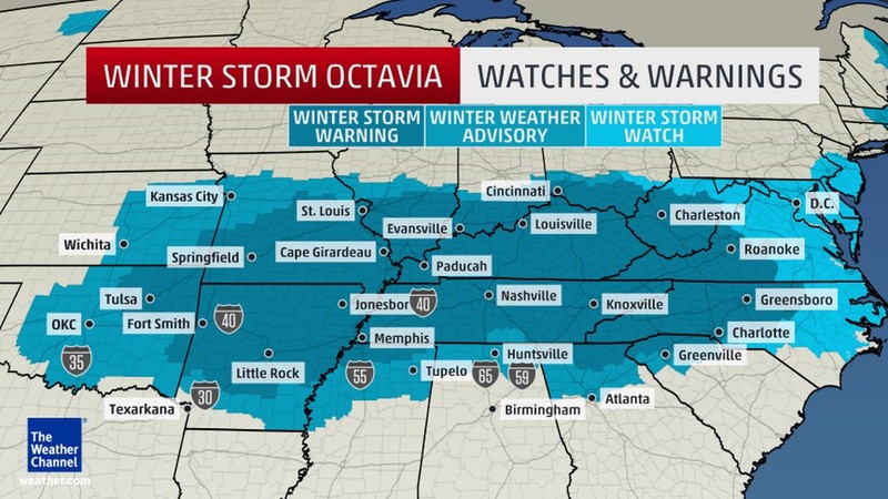
My love and interest in weather has always existed in me. Being a teenager my interest was only truly brought to the forefront less than three years ago during the February 2015 North American Cold Wave. To be exact it was the President's Day Snowstorm of 2015. I remember Sunday, February 15, vividly with anticipation as winter storm "Octavia" termed by the weather channel was on the march east. The snow on radar at one point spanned from Denver, Colorado to Roanoke, Virginia. That night and the next morning I binge watched the weather channel. During that night in fact as I was browsing I happened upon a forum called American Weather. The storm arrived Monday and the school had closed in advance of the storm due to President's Day. Around 10:30 A.M. the flakes started falling and they did not stop until late in the night. On Tuesday I awoke to a winter wonderland with just over a foot of snow on the ground. School remained closed for the rest of the month and multiple winter storms accompanied by arctic cold would follow in it's wake leaving a snow pack on the ground well into March. From there each year onward my interest in weather increased. Surprisingly I would remain a lurker on this site until this year. -

Southeast Sanitarium - A Place to Vent
BlunderStorm replied to Jonathan's topic in Southeastern States
I'm holding you up to that. Always that 1% chance.


![img_1034[1].jpg](https://www.americanwx.com/bb/uploads/monthly_2018_12/small.1221501886_img_10341.jpg.ada9a07c1ccdb83ad55319c249a06abd.jpg)

