BlunderStorm
-
Posts
1,235 -
Joined
-
Last visited
Content Type
Profiles
Blogs
Forums
American Weather
Media Demo
Store
Gallery
Everything posted by BlunderStorm
-

Oak Moon Upslope/ Upper Low Storm Obs
BlunderStorm replied to Holston_River_Rambler's topic in Tennessee Valley
As a general rule that model tends to exaggerate orographic dependent snow accumulations. Still it can be really fun to look at. -
Oak Moon Upslope/ Upper Low Storm Obs
BlunderStorm replied to Holston_River_Rambler's topic in Tennessee Valley
Kingsport/Gate City seeing any action yet? -
Oak Moon Upslope/ Upper Low Storm Obs
BlunderStorm replied to Holston_River_Rambler's topic in Tennessee Valley
I feel exactly the same and your description is identical to mine.- 300 replies
-
- 2
-

-
- upslope snow
- upper level disturbance
- (and 3 more)
-
Oak Moon Upslope/ Upper Low Storm Obs
BlunderStorm replied to Holston_River_Rambler's topic in Tennessee Valley
Still dry at the NE fringe of the forum region. Down to 36F and the radar presentation is looking really healthy.
- 300 replies
-
- 2
-
-
- upslope snow
- upper level disturbance
- (and 3 more)
-
Oak Moon Upslope/ Upper Low Storm Obs
BlunderStorm replied to Holston_River_Rambler's topic in Tennessee Valley
Tellico is a beautiful area having visited it during the eclipse.- 300 replies
-
- 2
-
-
- upslope snow
- upper level disturbance
- (and 3 more)
-
Oak Moon Upslope/ Upper Low Storm Obs
BlunderStorm replied to Holston_River_Rambler's topic in Tennessee Valley
@McMinnWx If he can get some flakes out of this you likely can too.- 300 replies
-
- 1
-
-
- upslope snow
- upper level disturbance
- (and 3 more)
-
Oak Moon Upslope/ Upper Low Storm Obs
BlunderStorm replied to Holston_River_Rambler's topic in Tennessee Valley
Good to hear, getting anything to stick in November is hard to pull off anyway. I'd consider it an appetizer. -
Oak Moon Upslope/ Upper Low Storm Obs
BlunderStorm replied to Holston_River_Rambler's topic in Tennessee Valley
It's reported along the southern plateau I buy it. Area around Sewanee and Monteagle is just under 2000'- 300 replies
-
- 4
-
-
- upslope snow
- upper level disturbance
- (and 3 more)
-
Oak Moon Upslope/ Upper Low Storm Obs
BlunderStorm replied to Holston_River_Rambler's topic in Tennessee Valley
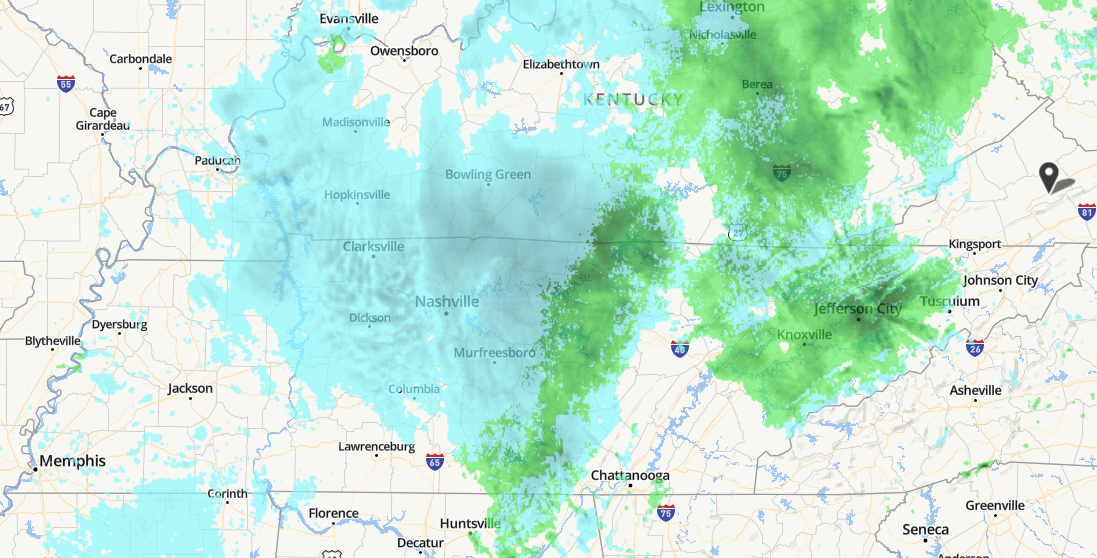
I wonder if any flakes are making it down under that light developing band over Nashville...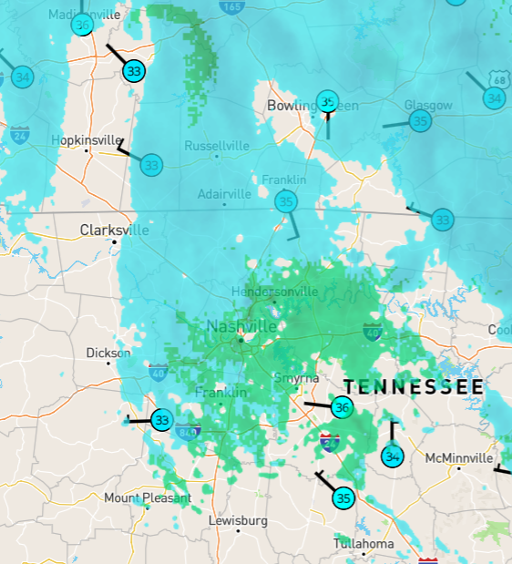
-
Oak Moon Upslope/ Upper Low Storm Obs
BlunderStorm replied to Holston_River_Rambler's topic in Tennessee Valley
Now down to 41F with a DP of 39. Was in and continue to be in the "dry pocket" (still some drizzle) but that much was a given thus far due to my location relative to the systems setup. Progression towards freezing is likely to accelerate as the front passes in the next hour. NWS is calling for an inch with models showing about 2 inches. -
Oak Moon Upslope/ Upper Low Storm Obs
BlunderStorm replied to Holston_River_Rambler's topic in Tennessee Valley
Currently 45F at 2100', will see how quickly the temps drop. Not extremely substantive but hey I'm here!- 300 replies
-
- 3
-
-
- upslope snow
- upper level disturbance
- (and 3 more)
-
![img_1034[1].jpg](https://www.americanwx.com/bb/uploads/monthly_2018_12/small.1221501886_img_10341.jpg.ada9a07c1ccdb83ad55319c249a06abd.jpg)
-
Lacking extensive knowledge of the effects of SSTs in different parts of the oceans and how they affect our weather patterns is a part of the reason you see little traffic in this thread. I can easily give observations, dish out banter and fantasy storms, and even give a rudimentary opinion as to what to expect a few weeks in advance, but beyond that I feel I cannot create a coherent post of value in this thread so I sit in the background instead attempting to learn. In other words I am aware of my own ignorance about the topic so I restrain myself and when I do make a post outside of banter or observations I try my best.
-
http://weather.rap.ucar.edu/ I don't believe this site has been shared on this thread. It's especially useful for it's snow&ice cover map as an alternative to https://www.ncdc.noaa.gov/snow-and-ice/snow-cover/ as well as having many other uses such as satellite imagery, NWS radar sites, and surface observations. You can thank Jax for finding it.
-
I had just been in Johnson City as the storms hit around dusk when about 30 minutes into one of the storms it began to hail. Luckily (pun intended) the hail was small and no damage was done to any cars or property at least from what I saw. I would say the hail was roughly a centimeter or a little more in diameter and it lasted around 5 minutes. Once the rain died down a little I came outside it looked like it had snowed in the grass. I thought the novelty of seeing significant snow and hail within a few days was pretty amusing truly March at its finest. Unfortunately I did not have a camera on me at the time so I didn't capture anything. It's also worth mentioning I saw some pretty spectacular streaks of lightning too.
-
Southeast Sanitarium - A Place to Vent
BlunderStorm replied to Jonathan's topic in Southeastern States
Still plenty of action left for Wilmington. At least you guys have a storm to follow it is pretty frustrating here in the Tennessee Valley with plenty of activity in the ohio valley and southeast. So far annual snowfall has thrown climate out of the window. Heaven forbid more than an inch of snow falls here. Still it does put a smile on my face when places like Tallahassee, Valdosta, and Savannah see snow. Even if it means sub-zero temps for me. -
How did you find the passion for weather?
BlunderStorm commented on USCAPEWEATHERAF's blog entry in Once a legend always a legend
My love and interest in weather has always existed in me. Being a teenager my interest was only truly brought to the forefront less than three years ago during the February 2015 North American Cold Wave. To be exact it was the President's Day Snowstorm of 2015. I remember Sunday, February 15, vividly with anticipation as winter storm "Octavia" termed by the weather channel was on the march east. The snow on radar at one point spanned from Denver, Colorado to Roanoke, Virginia. That night and the next morning I binge watched the weather channel. During that night in fact as I was browsing I happened upon a forum called American Weather. The storm arrived Monday and the school had closed in advance of the storm due to President's Day. Around 10:30 A.M. the flakes started falling and they did not stop until late in the night. On Tuesday I awoke to a winter wonderland with just over a foot of snow on the ground. School remained closed for the rest of the month and multiple winter storms accompanied by arctic cold would follow in it's wake leaving a snow pack on the ground well into March. From there each year onward my interest in weather increased. Surprisingly I would remain a lurker on this site until this year.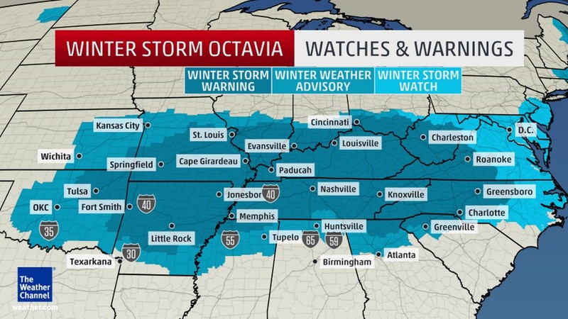
-
Would this work? http://compressimage.toolur.com/
-
You and I both Tellico! I have wanted to punt this system for the past 3 days but I'm always on the edge of being in this...Cmon, NW trend!
-
Southeast Sanitarium - A Place to Vent
BlunderStorm replied to Jonathan's topic in Southeastern States
I'm holding you up to that. Always that 1% chance.