BlunderStorm
-
Posts
1,171 -
Joined
-
Last visited
Content Type
Profiles
Blogs
Forums
American Weather
Media Demo
Store
Gallery
Everything posted by BlunderStorm
-
AREA FORECAST DISCUSSION...UPDATED National Weather Service Morristown TN 1249 AM EST Mon Dec 14 2020 .UPDATE... FOR 06Z AVIATION. && .DISCUSSION... Not a whole lot of change to the forecast this evening. Biggest change was to slightly delay onset of precip across the central east TN Valley and northeast TN by a few hours. Looking at the latest data, still a very difficult forecast in terms of snow potential across the northern Cumberland Plateau and southwest VA. I think the biggest bust potential is across Wise County and Russel County VA, our most northern counties in our CWA. By bust I mean our current snow totals could be too low. However, I just don`t feel confident enough to raise the current totals that are in place. To be honest, we probably won`t have a good grasp on snow totals until we actually see when the changeover occurs. With this event changeover-time is everything. A changeover from rain to snow that occurs just an hour or two earlier could raise snow totals by a few inches and vice versa if changeover is later than expected. The current SPS and snow totals mentioned within still look reasonable so will let it ride for now. Will be closely watching how this event unfolds through the night. SR
-
Down to 41. Since the arrival of the rain the temperatures have proceeded to drop steadily at a degree an hour. At this rate however the sun will stagnate the drop and the system will have already mostly concluded. Still, it is movement in the right direction and with any luck the drop in temperature will accelerate. On it's own evaporative cooling may give me another degree. Wetbulb is just under 40 with 94% humidity. All the more puzzling is the wind direction from the southwest from deeper in the valley not keeping the temperature at the very least stable. Furthermore if clouds insulate then why were temperatures stable instead of dropping in the first few hours of the night while the sky was still partially uncovered? Me no understand heat dissipation.
-
Alright, here we go. Snow? IMBY? Will see, Currently 43 and a long way to drop.
-

December 2020 Medium/Long Term Pattern Discussion.
BlunderStorm replied to John1122's topic in Tennessee Valley
Rates will overcome? -
December 2020 Medium/Long Term Pattern Discussion.
BlunderStorm replied to John1122's topic in Tennessee Valley
I noticed on the latest GFS run the first system that rolls through the midwest is more progressive perhaps introducing less cold to the Tennessee Valley in time for the second system. Another possibility is that with a stronger second system sporting a more defined center of low pressure it acts to warm up the valley without an area of high pressure to the NW reinforcing colder temps. If we were looking at more of a semi Miller A setup like we saw with the Euro last night perhaps it would be manageable for at least the eastern regions but this does not look to be the case with the euro biases and trend as of the 12z run. Instead echoing what Tellico said we may be looking at a weak to marginal slider with potential for snow in high elevations and maybe some lucky areas along I-40 and north. As a side-note the Canadian seems to be in general agreement with the GFS. In the meantime will see what the Euro has to say. On the bright side it would seem we will likely see multiple opportunities as December progresses and the effects of a -NAO and -AO really start to kick in. (fingers crossed) -
Oak Moon Upslope/ Upper Low Storm Obs
BlunderStorm replied to Holston_River_Rambler's topic in Tennessee Valley
It's looking like I end at 0.85"(ish) for the event. A few under the radar bursts managed to lay down a nice thin coating.- 300 replies
-
- 3
-

-
- upslope snow
- upper level disturbance
- (and 3 more)
-
Oak Moon Upslope/ Upper Low Storm Obs
BlunderStorm replied to Holston_River_Rambler's topic in Tennessee Valley
I know it's currently flurrying in downtown Nashville. https://www.webcamtaxi.com/en/usa/tennessee/broadway-nashville.html -
Oak Moon Upslope/ Upper Low Storm Obs
BlunderStorm replied to Holston_River_Rambler's topic in Tennessee Valley
Well it would seem barring some really good NW flow tonight out of everyone I have drawn the short end of the stick. Latitude and elevation be damned I got a trace. As for why, I dunno. Perhaps the atmosphere was drier here but I think it's more likely to do with the 2nd wave of energy in this system associated with the upper level low which tracked to my SW. I could be entirely wrong and I'm sure someone here would have a better understanding haha. For those of yall in harsher climos congrats though! -
Oak Moon Upslope/ Upper Low Storm Obs
BlunderStorm replied to Holston_River_Rambler's topic in Tennessee Valley
8 hours ago I would have agreed with their original call. I'm glad there were willing to let up in light of this systems overperformance.
- 300 replies
-
- 1
-
-
- upslope snow
- upper level disturbance
- (and 3 more)
-
Oak Moon Upslope/ Upper Low Storm Obs
BlunderStorm replied to Holston_River_Rambler's topic in Tennessee Valley
It is now steadily snowing at a moderate clip and temperatures are just barely hovering above freezing at 33. Snow has not began to accumulate on the grass however as of yet.- 300 replies
-
- 1
-
-
- upslope snow
- upper level disturbance
- (and 3 more)
-
Oak Moon Upslope/ Upper Low Storm Obs
BlunderStorm replied to Holston_River_Rambler's topic in Tennessee Valley
Clinch mountain for example to the north of MRX has a tendency to do that I believe. -
Oak Moon Upslope/ Upper Low Storm Obs
BlunderStorm replied to Holston_River_Rambler's topic in Tennessee Valley
At last I can now say snow is lightly falling! Currently 34F.- 300 replies
-
- 1
-
-
- upslope snow
- upper level disturbance
- (and 3 more)
-
Oak Moon Upslope/ Upper Low Storm Obs
BlunderStorm replied to Holston_River_Rambler's topic in Tennessee Valley
As a general rule that model tends to exaggerate orographic dependent snow accumulations. Still it can be really fun to look at. -
Oak Moon Upslope/ Upper Low Storm Obs
BlunderStorm replied to Holston_River_Rambler's topic in Tennessee Valley
Kingsport/Gate City seeing any action yet? -
Oak Moon Upslope/ Upper Low Storm Obs
BlunderStorm replied to Holston_River_Rambler's topic in Tennessee Valley
I feel exactly the same and your description is identical to mine.- 300 replies
-
- 2
-
-
- upslope snow
- upper level disturbance
- (and 3 more)
-
Oak Moon Upslope/ Upper Low Storm Obs
BlunderStorm replied to Holston_River_Rambler's topic in Tennessee Valley
Still dry at the NE fringe of the forum region. Down to 36F and the radar presentation is looking really healthy.
- 300 replies
-
- 2
-
-
- upslope snow
- upper level disturbance
- (and 3 more)
-
Oak Moon Upslope/ Upper Low Storm Obs
BlunderStorm replied to Holston_River_Rambler's topic in Tennessee Valley
Tellico is a beautiful area having visited it during the eclipse.- 300 replies
-
- 2
-
-
- upslope snow
- upper level disturbance
- (and 3 more)
-
Oak Moon Upslope/ Upper Low Storm Obs
BlunderStorm replied to Holston_River_Rambler's topic in Tennessee Valley
@McMinnWx If he can get some flakes out of this you likely can too.- 300 replies
-
- 1
-
-
- upslope snow
- upper level disturbance
- (and 3 more)
-
Oak Moon Upslope/ Upper Low Storm Obs
BlunderStorm replied to Holston_River_Rambler's topic in Tennessee Valley
Good to hear, getting anything to stick in November is hard to pull off anyway. I'd consider it an appetizer. -
Oak Moon Upslope/ Upper Low Storm Obs
BlunderStorm replied to Holston_River_Rambler's topic in Tennessee Valley
It's reported along the southern plateau I buy it. Area around Sewanee and Monteagle is just under 2000'- 300 replies
-
- 4
-
-
- upslope snow
- upper level disturbance
- (and 3 more)
-
Oak Moon Upslope/ Upper Low Storm Obs
BlunderStorm replied to Holston_River_Rambler's topic in Tennessee Valley
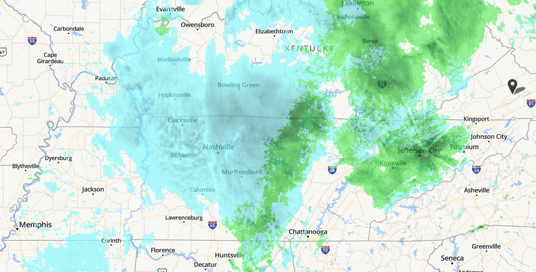
I wonder if any flakes are making it down under that light developing band over Nashville...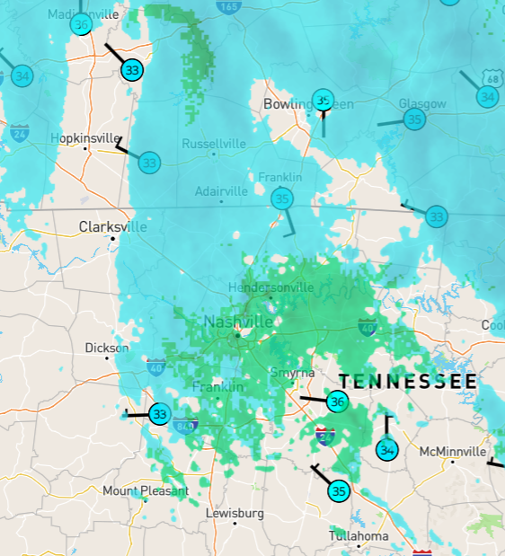
-
Oak Moon Upslope/ Upper Low Storm Obs
BlunderStorm replied to Holston_River_Rambler's topic in Tennessee Valley
Now down to 41F with a DP of 39. Was in and continue to be in the "dry pocket" (still some drizzle) but that much was a given thus far due to my location relative to the systems setup. Progression towards freezing is likely to accelerate as the front passes in the next hour. NWS is calling for an inch with models showing about 2 inches. -
Oak Moon Upslope/ Upper Low Storm Obs
BlunderStorm replied to Holston_River_Rambler's topic in Tennessee Valley
Currently 45F at 2100', will see how quickly the temps drop. Not extremely substantive but hey I'm here!- 300 replies
-
- 3
-
-
- upslope snow
- upper level disturbance
- (and 3 more)
-
Spring/Summer 2020 Observation Thread
BlunderStorm replied to Carvers Gap's topic in Tennessee Valley
For the record yes it is flurrying! Currently 34!- 186 replies
-
- 3
-
-

-
- tennessee river valley
- wind
- (and 4 more)
-
Leap Days Clipper Parade: February 26th-29th 2020
BlunderStorm replied to John1122's topic in Tennessee Valley
Looks like this is likely to be the biggest snowfall this season the way it's going here. Quite impressive