

HKY1894
-
Posts
190 -
Joined
-
Last visited
Content Type
Profiles
Blogs
Forums
American Weather
Media Demo
Store
Gallery
Everything posted by HKY1894
-
So in a general sense we have old gfs FV3 and now euro hammering areas of NC with massive snowstorm essentially. .
-
Big big QPF slow mover and colder temps this run as grit said. Starts snowing at 126 and still going at 144 .
-
More accurate representation of FV3 snowfall. .
-
I think Lenoir Wilkesboro Boone and Jefferson are in line for huge winter storm .
-
The snow on the backside that the gfs and FV3 have at 00z would be higher ratio stuff than the overrunning part of the storm I would think too. Need euro to be colder than 12z was now .
-
Yep FV3 has be very consistent for at least 2 days .
-
ICON has been warm every run I’ve looked at .
-
.
-
I feel like this is following how every winter storm goes, weigh climo heavily is smart decision for now. The euro thermal profile on op run was concerning at 12z but the ensemble looks better. I’m in the northwestern foothills and I’m not comfortable right now with temps. Feel like we could be looking at ZR even here. FV3 is dream run .
-
Yeah only if it were 24hrs out. Would be one of the all time greats here [emoji23] .
-
Yes I find it interesting that FV3 along with Euro and ukmet all have phase on 00z runs. Euro and ukmet have always been more reliable imo vs old gfs, this storm will be interesting test of new gfs. Honestly feel like euro and FV3 weren’t all that different at 0z. Somebody’s gonna get a massive snowstorm if this solution is close. Maybe mid Atlantic though .
-
I’m near lenoir wish I could lock this run in. So much timing with northern stream phase though nino climo heavily favors my area though so I’m confident in at least some form of wintry precip on front end at least .
-
.
-
FV3 is a crushing for all of WNC lots of ice farther east. Tons of QPF .
-
FV3 looks similar to 18z at 500mb out to 120 Southern Vort stronger. Taller ridge in pna region but nothing way different yet .
-
Gfs euro and FV3 gfs all show a major to almost historic storm for some part of carolinas although it’s 7 days out and will change this is one of strongest signals I’ve ever seen from so far out. Impressive .
-
COLD AND DRYI LOVE IT
-
The December to Remember 7th-8th blue turd winter threat thread.
HKY1894 replied to lilj4425's topic in Southeastern States
QPF totals from gfs? I’m too busy to look at work -
The December to Remember 7th-8th blue turd winter threat thread.
HKY1894 replied to lilj4425's topic in Southeastern States
Big increase in QPF from 12z ukie compared last nights 00z run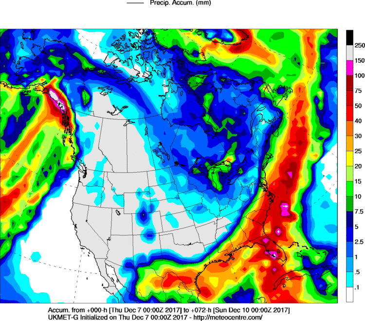
-
The December to Remember 7th-8th blue turd winter threat thread.
HKY1894 replied to lilj4425's topic in Southeastern States
This model has been so consistent for at least 3 days now -
The December to Remember 7th-8th blue turd winter threat thread.
HKY1894 replied to lilj4425's topic in Southeastern States
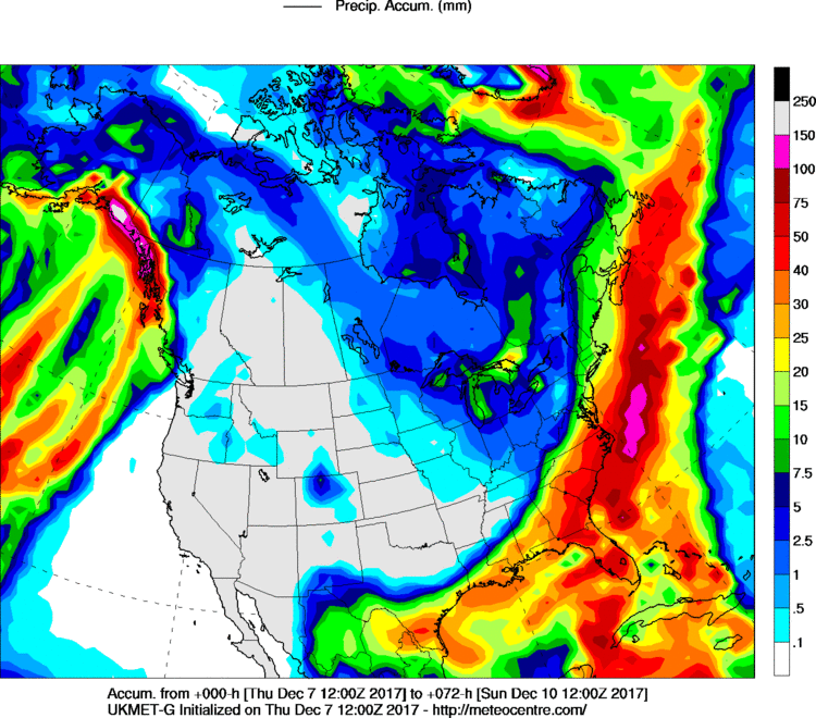
Ukie not quite as good as 12z yesterday. But much better than 0z. Trending back towards a good storm for WNC possible up into VA -
The December to Remember 7th-8th blue turd winter threat thread.
HKY1894 replied to lilj4425's topic in Southeastern States
It’s so odd how the NAVGEM is so amped up and has been for days. It’s notoriously a progressive model


