SnowDawg
-
Posts
1,070 -
Joined
-
Last visited
Content Type
Profiles
Blogs
Forums
American Weather
Media Demo
Store
Gallery
Everything posted by SnowDawg
-
Despite the fun OP runs yesterday, the ensemble largely favored suppression the whole time. We've gotta have stronger earlier cyclogenesis.
-
The GFS has been remarkably consistent around the evolution of the storm. It's wobbled back and forth on the southward extent of the PV lobe and the LP track and timing. All to be expected at this range. That being said, it does have Euro like solutions within its ensemble. I'd be prepared for at least one more big swing from the models after today's big cutter clears and resets the playing field. Even then, given the complex nature and so many moving pieces, this could end up coming down to the wire on having any real confidence in a solution.
-
Yeah generally the same look overall, pv lobe just a bit further north. Too small of changes to nitpick over at this range. Interesting trend of that HP to the northeast trying to hang out a bit longer. Could help slow our system down, and maybe even deliver a bit of CAD to help with temps.
-
Yep, verbatim it's winter weather potential all the way to the end of the run.
-
GFS Ensemble favors suppression at the time which is not a bad place to be. Don't wanna be in the bullseye yet.
-
EPS has led the way with this look so far. Started trending that way a day or two ago. Glad to see GFS moving that way. Long ways to go though. At least theres something to track.
-

2023-2024 Fall/Winter Mountain Thread
SnowDawg replied to The Alchemist's topic in Southeastern States
Well got a solid dusting on elevated surfaces, but nothing out in the yard. So for me, I'm not counting it as a measurable event. Still shutout for the 2nd year in a row right now. All it takes is one surprise though, in a generally favorable 500 mbar pattern going forward. -
EPS again says it's too early at this point to give up on the threat. Mean low pressure track is south and east of the OP. Many members are establishing a defined low as early as the northern gulf/FL panhandle area. Then it's a mixed bag of inland and offshore tracks. Snow means increased a bit over the mountains from 0z.
-
2023-2024 Fall/Winter Mountain Thread
SnowDawg replied to The Alchemist's topic in Southeastern States
I think the wedge boundary may be protecting us from the higher winds for now at least. -
Your guess is as good as mine. We're talking OP models at 10 days, we'd be just as well off throwing cans of blue and orange paint agaisnt the wall.
-
Looks temporary. Blocks still in place and another shot on its way SE with PNA starting to push north. With that block and 50/50 in place, if the PNA can pump enough for a wave to dig I'd say that's a threatening look for around the 20th.

-
EPS mean is way SE of the OP with the low track. Members are all over the map, so no real consensus forming at this point. If you take the GFS progressive bias and the Euro's amplification bias, an in the middle solution might work for a light/moderate event for at least part of the forum. I'm not leaning one way or the other at this point, there's probably still big model shifts coming as these two big storms set the playing field.
-
2023-2024 Fall/Winter Mountain Thread
SnowDawg replied to The Alchemist's topic in Southeastern States
3.59" already and radar remains juicy. Definitely heading for 6+ at this rate. -
2023-2024 Fall/Winter Mountain Thread
SnowDawg replied to The Alchemist's topic in Southeastern States
That first wave that came through was all sleet here. Silly as it may be, was nice to see something other than rain for the first time all winter lol. Now to enjoy the last few moments of dry, as that slug of moisture coming in from the south is looking mighty impressive. -
So you're telling me there's a chance...
-
16th/17th definitely a consistent threat both on OP and Ensemble runs at this point, but it's gonna be a tricky one to track given the uncertainty that these two anomalously strong storms between now and then are going to cause in the models. Particularly the 2nd one this weekend, as it appears likely to phase with the TPV lobe and exactly where that big low sets up ahead of our target wave will have big impacts. Ideally, we need it to trend east as close to the 50/50 region as we can get it, as opposed to further west where the 12z GFS showed it.
-
16th/17th was really close and certainly not a bad look 9 days out. Ensemble actually has a suppressed look for that storm at the moment.
-
I think it's clear that at least for a period, cold air supply will not be a big problem. It's gonna come down to storm track. Really need a well timed PNA spike to keep a wave from cutting, but not so strong to suppress the pattern too much and send it out to sea. Snow is never easy in the south.
-
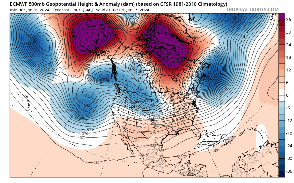
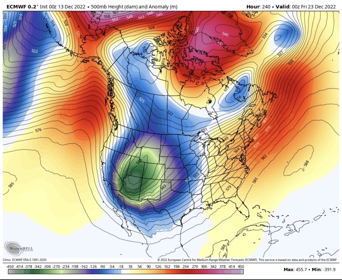
I wouldn't say it's a delay, the first cold shot arrives right on time it's just transient because the PV lobe is stuck out west instead of slowly sliding up under our NAO block. I think at times, especially with these anomalous pv type cold shots the models can have feedback issues with the Rockies. This was the December 2022 cold blast on the Euro at day 10, stuck in the Rockies. We ended up cold and dry though which is certainly a worry. As always there's more ways for things to wrong than right, especially at the lead times we're talking. We may have an idea but I doubt we've seen yet just how this is going to go on modeling.

-
Considering how much he's enjoyed destroying all our hope the last few years, this is one person I'm glad to see on board lol https://x.com/webberweather/status/1743727117710368793?s=46&t=BVabKZBl0JP2qfoqs7LgyQ
-
Last I saw was this from the Euro weeklies a couple days ago.
-
2023-2024 Fall/Winter Mountain Thread
SnowDawg replied to The Alchemist's topic in Southeastern States
Yeah I can't remember the last time ice was accurately modeled in my location. Either it busts warm like last night, or the surface cold ends up just deep enough to support mostly sleet. The latter has been a saving grace several times in the last 10-20 years for me, while just to my south they have had some devastating ice storms. -
2023-2024 Fall/Winter Mountain Thread
SnowDawg replied to The Alchemist's topic in Southeastern States
Been warming pretty steadily here for a bit. Getting a moist south/southeast flow at the surface raising temps and dews. -
Southeast Sanitarium - Winter 23/24 Edition
SnowDawg replied to eyewall's topic in Southeastern States
I mean sure I guess, but we have barely even had a long range genuinely favorable look for winter storms this winter. This brief early January window was the first period that looked promising at a distance, and arguably we got two near misses out of it. One sheared and suppressed to the south a couple days ago and one CAD setup without enough antecedent cold air or strong enough high. -
Southeast Sanitarium - Winter 23/24 Edition
SnowDawg replied to eyewall's topic in Southeastern States
Genuinely jealous of people who didn't fall into the trap of this hobby. Weather models are basically crack from what I can tell. Everytime I try to tell myself to just stop looking, I find myself waking up at 2am just to sneak a peak at the Euro lol