SnowDawg
-
Posts
1,070 -
Joined
-
Last visited
Content Type
Profiles
Blogs
Forums
American Weather
Media Demo
Store
Gallery
Everything posted by SnowDawg
-
Not entirely surprising I'd say. I think we knew more often than not the extreme cold tends to moderate some as we close in. Still beyond cold enough for winter weather. Track, timing, and intensity all need to lineup for that though.
-
Same on Wxbell
-
Big drop in QPF, looks suppressed. Huge QPF spike out over the Gulf of Mexico. I'm betting most members followed the op in shearing out/leaving behind the southern energy.
-
Definitely need to watch how that CAD trends on the 6th system. As we know global models at this range often underestimate it and still it had most of the prime CAD region in the mid to upper 20's. Could be a nasty sleet/zr setup.
-
Another run with our southern piece of energy getting cutoff and left behind out west. This is our most likely path to failure on the Miller A potential. Without getting even a partial phase, it'll be too northern stream dominant. That's why it's important that the H5 look come to fruition, cause we should get more than one shot at it.
-
I'm sorry but the 6th has never really been the threat. Just because a few op runs have tried to show it doesn't make it so. As Eric Webb said yesterday this is a classic step down winter pattern that we've seen a thousand times in the south. 1: Clipper (3rd/4th), 2:Cutter with CAD potential (6th/7th), 3: Miller A potential anywhere from the Gulf coast to the mid-atlantic 8th-10th. As for the ensemble means, looking at the meteograms the Miller A threat itself hasn't budged. The reduction in means is largely due to outlier members showing significant snows from the Clipper/cutter dropping, as should be expected.
-
Biggest failure on the GFS is not enough separation between the stage setting storm on the 5th/6th and the trailing wave. We need a full day or two between them instead it's right on its tail which one prevents the cold from pushing in ahead of it and doesn't give it room to truly amplify. We want the first one to clear through and enhance the 50/50 low to entrench our cold air, then have our trailing wave move in along th thermal boundary. Way too small of a detail to worry at this time, models could still be struggling to key in on specific pieces of energy. Main thing is that the H5 look is still consistent, and is a look that historically has been kind to us.
-
Several rounds of winter weather on the 18z gfs and another on the way in as the run ends.
-
Very well might have followed that up with our big dog from last night had the energy not got left behind in the SW.
-
Also, I want a big dog as much as anybody. But going on 3 years without snow, after never going a single winter without before, I'd be thrilled just to get an inch or two from a potent clipper. Hell an aggressive flizzard would probably be enough to put a smile on my face lol.
-
The means go up and down with every run. Especially the GEFS and it's underdispersal bias, and tendency to be over influenced by individual members compared to the EPS. At this lead time H5 is all that matters, and nothing has changed in the last few days other than actually a few minor adjustments for the better. I believe the first storm around the 6th cutting could actually be crucial to enhancing the 50/50 ahead of the second one. Then it all comes down to timing a phase, always hard to do, but the block and 50/50 can make it easier. Betting on cold and dry is smart though if you don't wanna be let down. It's always the easiest outcome.
-
At least with this one unlike most, the ensembles started barking first. Never any guarantees and I'm sure we'll see some back and forth, but this is as good a signal as we've seen in a very long time. Nice to at least have something worth talking about.
-
Just ridiculous... High ratio snow in the mountains and foothills.

-
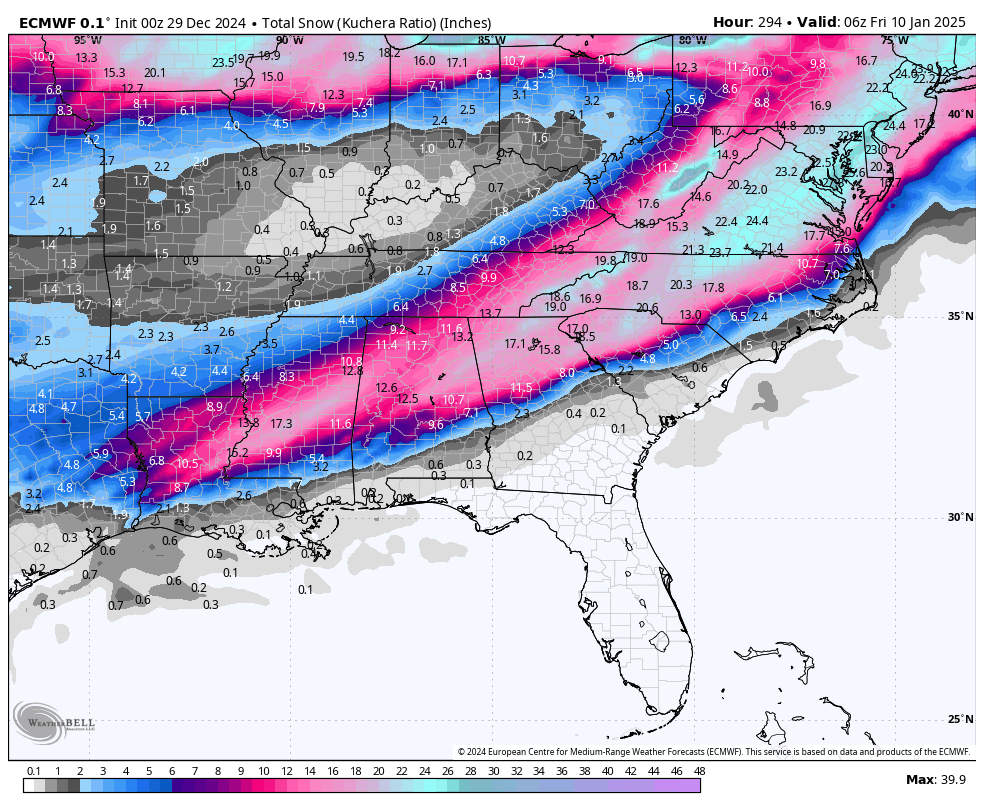
Holy smokes Euro.... Just an absolute perfect system. If only that was under 5 days.... This whole board deserves to end this drought on a storm like that.
-
You need to just keep asking for things please, cause seems the models just keep delivering on the very next run lol. I mean wow....about as perfect of a fantasy snow storm I've ever seen.
-
Overall a great look at this lead time. I'd take my chances that the stout 50/50 along with the arctic highs coming down would force that track a little further south. Regardless meaningless details at this point. Takeaway is pattern is there to support a miller A system.
-
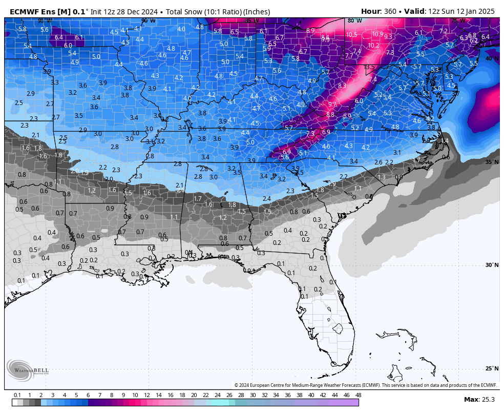
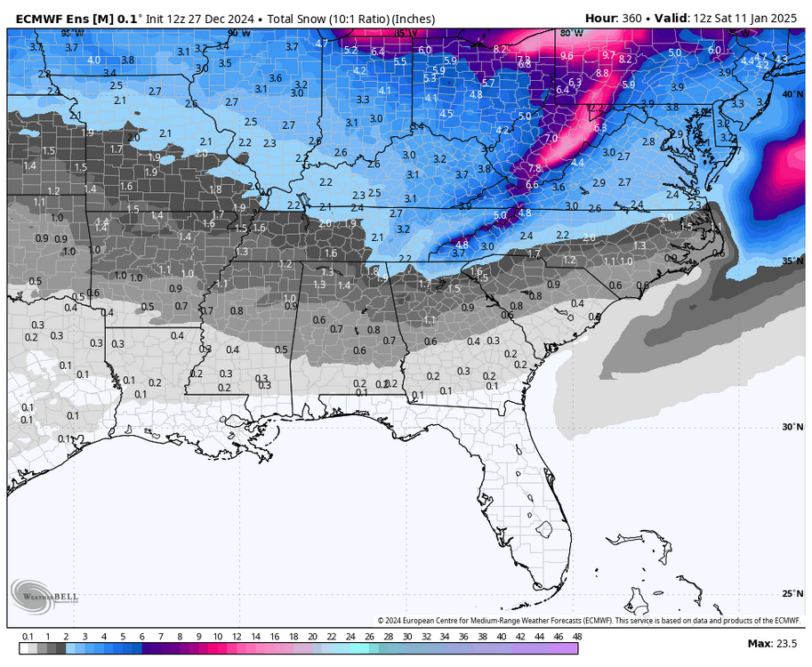
New EPS snow mean. Starts around the 5th and just adds on nonstop through the end of the run. Getting multiple threats in this window could be huge, since as we all know we fail far more than we succeed.
-
Yep best run yet by far as I can tell.
-
I would argue the 8th-10th was actually quite close had the energy not got left behind back in the Rockies. You can see it start to organize in the southern plains and then gets sheared apart as the phase fails.
-
Very strange post from them. Using an old month long temperature outlook when everything currently valid from the CPC all the way out to January 24th is for well below normal temps in the east. Zero chance January is above normal if that is even close. Also, NOAA has still yet to declare LA Niña as enso neutral conditions continue to persist. Even if so it'd be extremely weak, and the MJO far more likely to drive the overall pattern.
-
Insane run. Snow on the ground and temps below zero for nearly 40 hours throughout TN, North GA, and W NC. I want snow as much as anybody, but that we can leave out in fantasy land where it belongs.
-
That was one of the best runs of the ensembles we've seen yet. Lots of small improvements at H5 which unsurprisingly led to a nice bump in snow means.
-
That GFS run really showed what a good -NAO can do for us if it can really be that persistent. I often feel like the effects of that kind of blocking are poorly modeled in the long range, so will be interesting to watch going forward.
-
At least for as far as we can reliably see, I think we really need that 6th-10th system to be the one. Late week two and week 3 of January could still hold promise but I hate betting on an unseeable future, when that timeframe is just a few small ticks from paydirt.
-
I remember a surprise sometime in that time frame too, one I'm remembering could've been in 2011/12 though not sure. I remember being forecasted flurries and then getting stuck at a friend's house with 4 or so inches. At least for us N GA and Upstate SC folks I'd call February 8th, 2020 a surprise, especially by modern standards. Most went to bed forecast rn/sn no accumulation, then woke up to WSW's and ended up with 3-6.