SnowDawg
-
Posts
1,070 -
Joined
-
Last visited
Content Type
Profiles
Blogs
Forums
American Weather
Media Demo
Store
Gallery
Everything posted by SnowDawg
-
NAM and GFS seem to be even further apart than they were at 18z with the handling of the vort at H5. I know the dangers of the NAM at the end of its range, but it treated me so well in this last event that I am going to hug it until the bitter end if I have to lol.
-
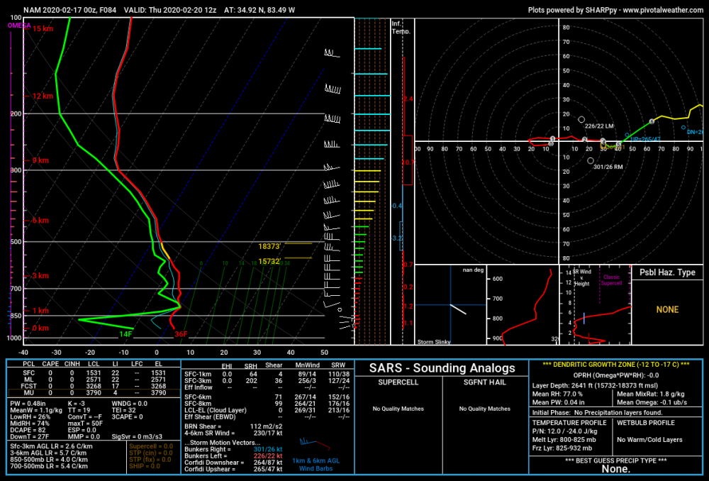
NAM soundings for N GA mountains at HR 84. Surface wet bulb is below freezing. Just somehow someway need some sufficient moisture to run into it.
-
Just pulled soundings for my area in N GA and had an east wind at the surface. Also a typical CAD/Wedge signal.
-
Noticed on the individual members that a few big time snow totals showed up also. I don't think I've seen much of that on the EPS the last few days.
-
Timing differences between the GFS and NAM are fairly significant. NAM holds the vort back a bit more and the mid/upper level wind field over the SE is much more friendly for moisture transport. 850's still above freezing but they are crashing with surface temps in the region in the 36-40 range with still 6hrs of darkness left. I know it's the NAM at range but it definitely earned some respect with last weekends event here in my book. It led the way from the minute it came into range.
-
It really did look better at the beginning at H5. Wonder what went wrong? Looks like it may have did what the WPC was talking about with the UKMET trying to rotate the pacific shortwave underneath the northern stream one which they alluded to likely being too fast/strong. Just speculation though, someone with more knowledge would probably know for sure though.
-
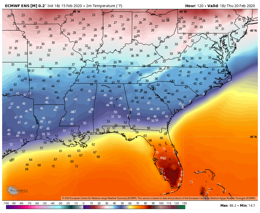
Surface temps in the region as much as 6+ degrees colder than the GFS at 06z Thursday in some places. 700mbar winds are WSW throughout the whole region and the vort is consolidated and digging, with some fairly potent energy already streaming in along the boundary.
-
I may just be wish casting but I swear the NAM looks pretty great at the end of its run.
-

2019/2020 Mountains and Foothills Fall/Winter Thread.
SnowDawg replied to Tyler Penland's topic in Southeastern States
From the pics I've seen 2017 was pretty great here in the N GA mountains also. I was unfortunately in Athens that day with a 34 degree rain so I missed it. Is the tilt and alignment of the trough next week at all similar to that setup or was it much less positively tilted? -
Really just the region as a whole. It has been very consistent with the suppressed look. 8 or so good members but out of 51 those aren't great odds. Most of the region outside of Coastal NC/SC currently has less than a 30% probability of QPF greater than a tenth of an inch.
-
Outside of the one 18z run yesterday the EPS has been pretty locked in, not sure I'd bet against it at this point. Hoping to be wrong though.
-
Very reminiscent of last week today. The models have just been vastly underestimating these weak shortwave driven events.
-
Wow, 18 members with snow IMBY and 8 with over 2 inches. Problem is a big chunk will probably be wasted trying to cool the surface. I wish there was just a bit more separation behind the cold front so we could clear out the cloud deck and radiate down.
-
Most concerning trend of late to me is the 850s look a lot warmer than they did a day or two ago.
-
EPS control and mean stepped back from the big run at 18z but are still drastically improved from 12z.
-
It's much improved over the 12z run but ultimately still suppressed for the most part. It looks very similar to the CMC. The 18z run was from the EPS which I don't think has started yet.
-
The way things are modeled right now, could this end up just being a thin strip of snow where the best rates and cold 850's overlap but rain on either side?
-
It's definitely a bit warmer but 850's are still below freezing across most of the region all day Thursday. Even on the mean, the surface temps reflect the precip being further north driving the temps down in the middle of the day Thursday. 18z 1PM Temps 12z
.thumb.png.e6cb049db4a14021b241affa2377e4f5.png)
-
The QPF and snow total noticeably ticked up on the ensemble mean also.
-
EPS has maybe 5-6 members max with anything noteworthy in the SE.
-
Temps are not an issue, there just isn't any precip falling through the cold upper level air to help drive the boundary temps down. Suppression is still the issue, with the NS moving through too fast. Mid level winds turn WNW by 7 AM Thursday and shutoff moisture transport.
-
Euro moved back closer to a good solution by slowing down the NS energy, but still suppressed.
-
Don't know if anyone mentioned it or not but UKMET joined the suppressed camp also.
-
Canadian still playing along, albeit over a much smaller geographical area.
-
EPS does not look good at all... Changes in the Euro suite from 12z yesterday to today are subtle, but they are significant.


.png.9083d25a7e46084768b6464a12b1ce33.png)