SnowDawg
-
Posts
1,070 -
Joined
-
Last visited
Content Type
Profiles
Blogs
Forums
American Weather
Media Demo
Store
Gallery
Everything posted by SnowDawg
-
I generally agree for your area. But I thought the same thing 24-36 hrs ago for my own. I confidently thought that the only limiting factor in my area would be moisture because I was solidly entrenched within the upper level cold on all the models.
-
It very much depends on where you are lol. I'd really like the NAM to trend back southwards down the stretch. Not even with the precip, just the southern fringes of the frozen stuff.
-
Welp... Just got screw zoned on that one. Dropped from 5 inches mostly snow on last run to under 2 inches of wet slop... Sincerely hope it is over-amped and thus too warm.
-
Eh, I wouldn't say that. Euro and NAM are extremely far a part. NAM is just consistently moving the southern fringes slightly further north.
-
NAM really warming aloft on 3 straight runs now. Went from solid likely snow from the start to probably starting as rain or mix if I'm lucky now.
-
The 6z Euro was not drier than the 0z run. Definitely still drier than other models, but the main/control/mean all bumped slightly north with QPF. It just spent over a whole day going back and forth with every single run.
-
Pretty dramatic jump northward on that run with the snow totals. As someone getting closer and closer to the southern fringes, this is not a trend I want to see continue.
-
850s didn't change very much. It's warmer at the surface because of less precip and therefore less wet bulbing. I would assume that's what is showing on the UKMET also. That is what the surface will look like without sufficient QPF.
-
Wow, Canadian is significantly warmer than GFS/NAM. I thought that it was generally one of the coldest models most of the time? Or is that something that has been fixed in their recent upgrades? The fact that it's apparently a better model than the GFS now isn't comforting lol
-

2019/2020 Mountains and Foothills Fall/Winter Thread.
SnowDawg replied to Tyler Penland's topic in Southeastern States
I'm glad I'm not the only one who feels maybe a little over confident at this point. Even down here in the far NE GA Mtns I feel really good about where we're sitting right now as potentially being in a good spot for an overlap of the upper level cold and good QPF. Most modeling has been pretty consistent of the upper level cold beating the moisture in and starting with a surface temp of 35-37. May lose a little QPF initially during wet-bulbing but shouldn't take long. Confidence probably gonna come back to bite me, but being just about a week removed from a major over-performer has me feeling a bit more risky right now lol. -
I'm assuming the same applies for the N GA Mtns? I thought the run looked good but for some reason it kept it as rain throughout. Seems to me looking at the thermal profiles on basically all the models, it feels like the main limiting factor in this area would be QPF, not temps. I really expected with it showing around 0.5 QPF it would have looked better.
-
I think we are starting to move into the time range where the globals aren't as useful. I'd say a safe bet right now is somewhere between what the NAM and the globals are showing, and hope the trends over time move things closer towards the NAM.
-
NAM 3km is much closer to the 12km at H5 than it is to the GFS at the end of its run that's for sure.
-
Not really. Last frame.
-
5.5 inches. Stuck immediately and admittedly a very heavy frost that morning helped with that.
-
These tweets from Eric along with the massive bust by the global models just over a week ago is why I'm willing to go out on a limb with the short range guidance. If they trend downward as we approach, I'm out.
-
My 2 inch soil temp on Feb 7th was 43.7 and 55.5 on the 6th.
-
I would tend to agree, but with the previous weekends event it was also paltry with QPF from like day 4 until inside the last 24 hrs. The only reason I'm willing to be at least somewhat hopeful even with it showing that.
-
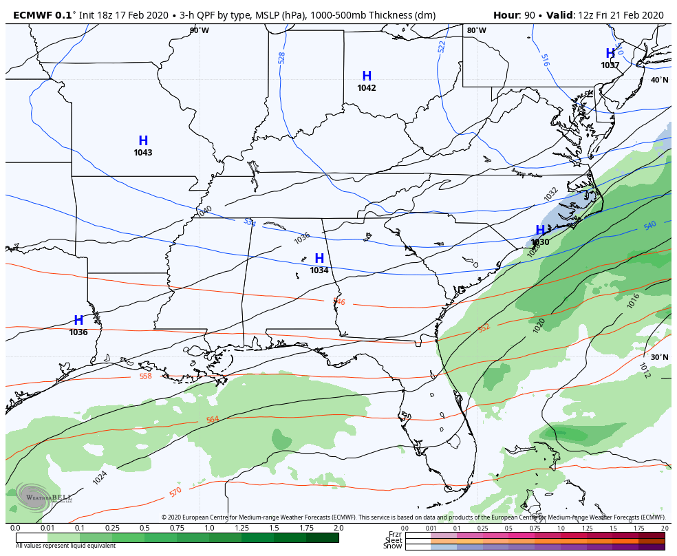
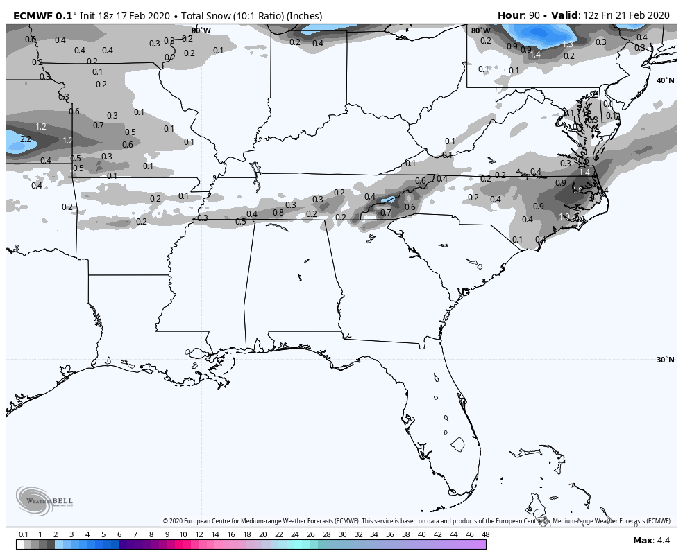
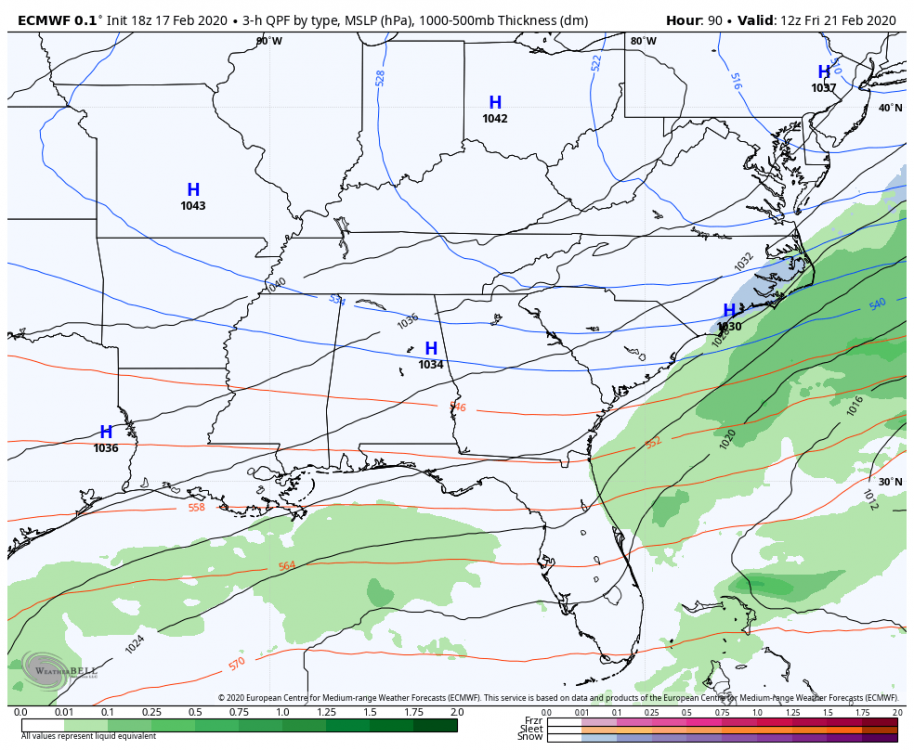
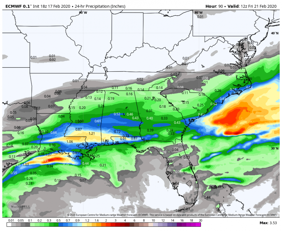
24 HR QPF and snow total. Hopefully it's in the lower half of its own ensemble suite.

-
Euro ticks back a bit on QPF. It remains to be not very impressed with this setup.
-
Every single member with at least an inch IMBY and 14 members with 2+. I'm nervous seeing that look still this far out.
-
Wow, honestly a bit aggressive there from GSP. Surprising for this far out.
-
Question, are we referring to a northward expansion of the precip shield and a NW trend as the same thing? As was said, a significant NW trend seems unlikely because of the energy dropping in from the NW. But I feel what a lot of us really want is the wave to dig more SW and simply have better moisture transport northward during the over running portion of the event. I know globals are often terrible for QPF on the northern fringes of over running events, so that's what I'm pinning my hopes on IMBY.
-
Has the Euro had a tendency to be too warm at the surface lately? I know it was with the 2/8 event. 850s are right at freezing and crashing as the precip arrives, but it's in the low 40s at the surface. If that was more in the 36-38 range I'd feel a lot better about evaporational cooling being enough to overcome the boundary.
-
Glad to see it not look so suppressed with the moisture. Just hoping it's underestimating the cold at 850.