SnowDawg
-
Posts
1,070 -
Joined
-
Last visited
Content Type
Profiles
Blogs
Forums
American Weather
Media Demo
Store
Gallery
Everything posted by SnowDawg
-

2019/2020 Mountains and Foothills Fall/Winter Thread.
SnowDawg replied to Tyler Penland's topic in Southeastern States
GFS looking a little quicker with precip and a tad warmer. -
ICON has been basically all rain. It's well known for being a bit too toasty at times. I wouldn't worry too much about it ever outside of seeing if it agrees with the bigger picture.
-
Said it earlier, I just can't ever trust any model that wants to show a change to snow after that many hours of rain. It's never as fast as shown and the back end always dries out faster than modeled. Anyone who's lived in warm nose territory I'm sure would agree.
-
Still good for NC looks like. Getting close to time to throw in the towel in GA and SC though looks like. GFS gave hope at 18z but every run of the NAM has just exploded with more and more warmth in the mid-levels.
-
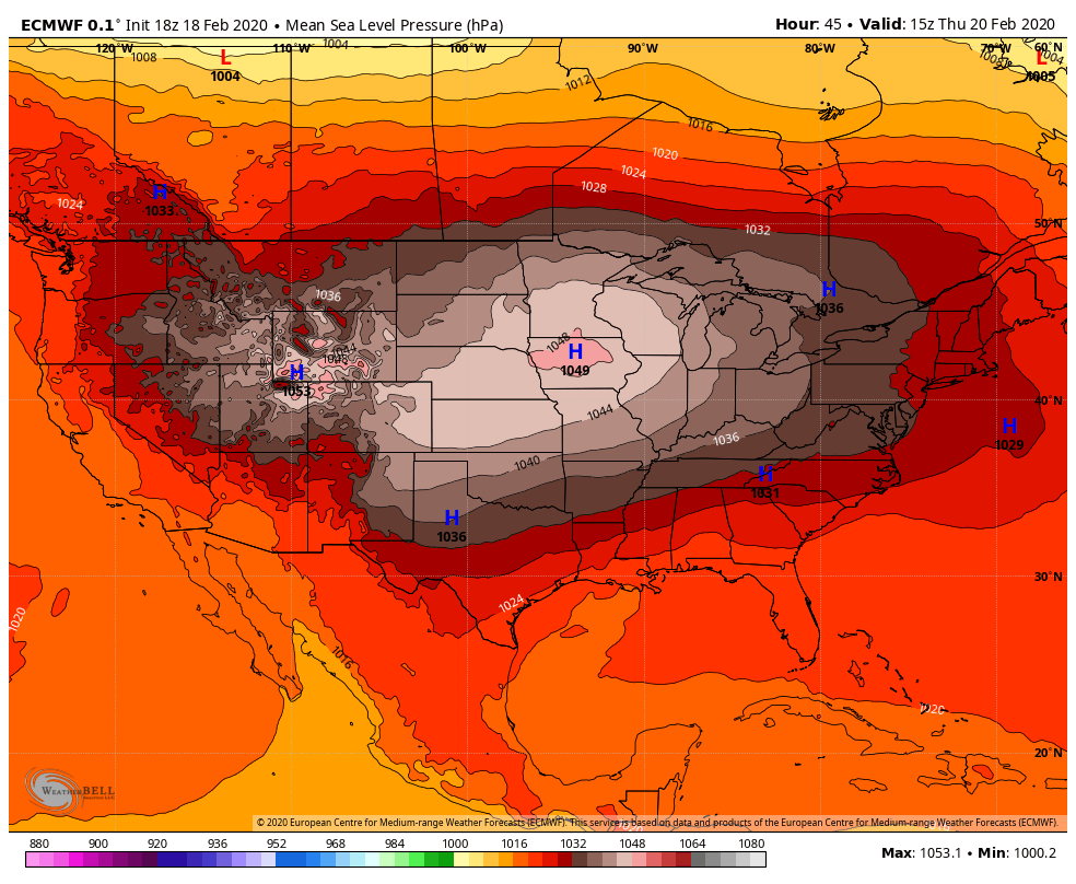
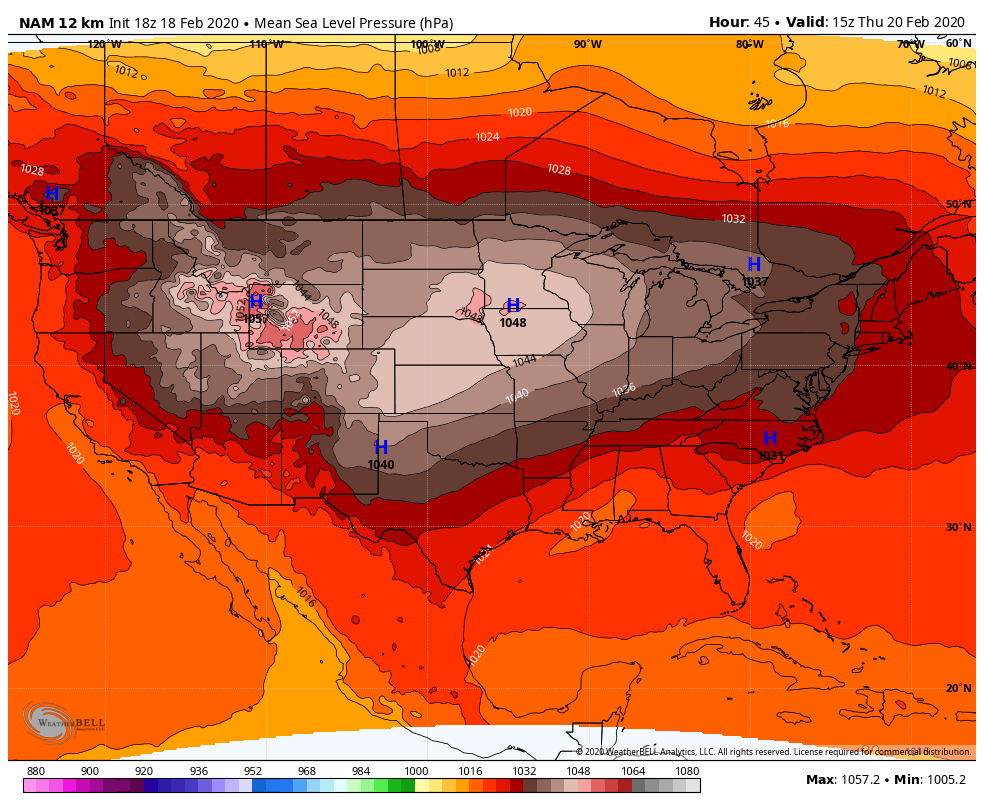
Higher surface pressures bleeding into the SE faster this run at HR 24
-
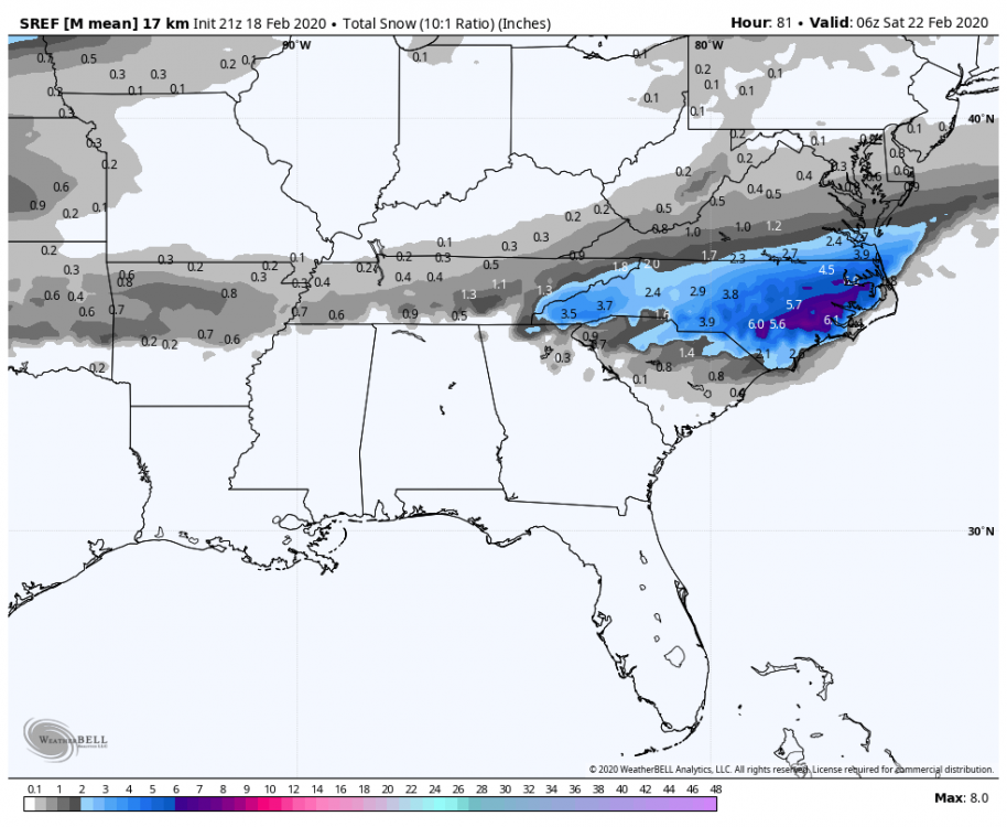
SREF just completely caved to the NAM too. Probably doubled snowfall in places from its previous run.
.thumb.png.64685f55a0f0818093f1e0f71d171fda.png)
-
Lol of course SE local mets are going to start with the whole soil temps nonsense. It's almost like they don't know all that much about snow storms. Soil temps almost never matter in a noticeable way. Well documented soil temps were in the mid to upper 50s last week in GA and it certainly didn't hinder accumulations, and where the rates were heavy roads quickly became snowpacked. Also, many of our most infamous storms in history were immediately preceded by several 70+ degree days lol.
-
Which, at this lead we should be using short term guidance more for thermals I believe? So as long as the Euro keeps bringing the juice I think it may self correct at crunch time.
-
It's in basically the same place on all the models, NAM and GFS included so I'm not certain that's it. I thought that's been mentioned as like the perfect placement for strong HP during Miller A/over running? Looking at the pressure maps on the Euro vs the NAM. The NAM shows the high spilling over the Apps and creating a bit of a wedge signal. Idk if that is the reason for low snow, or if it's even significant though.


-
@PackGrad05 Instead of trying to embed it just hit "Copy link to tweet." Then paste it in the comment and hit enter and it will automatically pop up.
-
Pretty substantial jump north with QPF on Euro. It's snow maps don't make much sense looking at the upper thermals though. It's trying to show an all rain event for most of the area except WNC. And a changeover in the latter half for ENC.
-
HRRR at least with last weeks event was several degrees too warm area wide so that's a pretty wild solution there. Of course I'm speaking about the 18 HR one not the experimental, idk if it has any biases or not on those long runs.
-
Was just looking at the same thing. I've seen it go both ways in this scenario. I've seen it bottom out at 34 and refuse to budge and I've also seen the heavy snow falling through the sub freezing column above give that extra degree or two needed. I guess only time will tell in that regard.
-
2019/2020 Mountains and Foothills Fall/Winter Thread.
SnowDawg replied to Tyler Penland's topic in Southeastern States
Very encouraging quicker erosion of the warm nose here in the GA Mtns. Problem is it's a coarse global model and the NAM is probably better for that. Gonna be a long 24 hrs of model runs, sitting right on the dividing line. -
That last runs push back south against the warm nose is very encouraging. Hope to see that become a trend.
-
Yeah, little over a week ago was the same story. Models didn't really converge until inside 24 hrs.
-
My confidence is definitely decreasing now for NGA Mtns outside of the highest elevations. NAM is extremely consistent with the mid level temps being an issue. I don't trust any model showing 6+ hours of rain changing over to snow.
-
Mean went down again.
-
Yeah a this time yesterday I would've said no doubt safe bet for some snow. But man the NAM and GFS are trending quickly in the wrong direction for mid-level temps even up here in the Mtns. If they do end up being over amped then I'd expect snow totals in the N GA Mtns to tick back upward. If not though, then it's probably going to just be a long day of sloppy wintry mix.
-
Despite being poorly worded my post about the NWS really wasn't meant as a shot. Conservative is absolutely the right play right now. My point was more aimed at not getting upset or anxious about them not being gung-ho for snow right now when they are just hedging their bets and biding their time. It really has no bearing on what will or will not happen.
-
That wasn't really my point. Just saying that in this situation where the globals are all over the place and the short term guidance like the NAM still making large run to run shifts, we shouldn't really expect a confident settled forecast until potentially a very short lead time. Eventually the data will coalesce, but I'm not predicting which way that will go.
-
Yep, it was really the last 24-36 hours of short term modeling that nailed the forecast then. And thus why the NWS was hesitant to believe it because the global models were hesitant to follow suit until inside 12-24hrs. I was feeling very confident for this one but trends on the GFS and NAM have scared me because of ptype issues. But if they are a little over amped right now then I think my area will end up in a fairly decent spot.
-
It would appear so but no surface temps were not an issue on the UKMET. It's the same issue it has had since the beginning and that's extremely suppressed moisture. Again, this is what the surface temps over NC are going to look like if there is no sufficient precip to drive down the temp.
-
Guys the NWS will stay conservative as long as they possibly can, sometimes to their own peril. I had a forecast of 0 inches and R/S mix 12 hours before getting almost 6 inches a little over a week ago.
-
Just looking there on weather nerds the warm nose looks most substantial from 750 to 800 mbars and isn't really showing up much at 850. So that's why we can't see it on temp maps on most sites.


.png.f52a604432434f187ed3f5c770049011.png)