SnowDawg
-
Posts
1,070 -
Joined
-
Last visited
Content Type
Profiles
Blogs
Forums
American Weather
Media Demo
Store
Gallery
Everything posted by SnowDawg
-
Yeah, for one you guys have much better dewpoint depressions to work with than I did. Needed a more mature CAD back this far SW to help force that low level dry air in.
-
Guess I jinxed myself here. Currently 37.2 and raining....
-

February 19-20 Major Winter Storm Threat
SnowDawg replied to NorthHillsWx's topic in Southeastern States
With any luck that gulf convection is overdone to an extent given the NAMs bias. But still...not really any positives to take from that. -
33/26.4 NAM and HRRR initialized 5-10 degrees too warm. Doesn't really matter overall given moisture will likely be the issue here, but at least maybe none will be wasted on rain.
-
February 19-20 Major Winter Storm Threat
SnowDawg replied to NorthHillsWx's topic in Southeastern States
Shame that this winters theme has been disorganized weak messy storms. Still better than the last three years, but feels like a missed opportunity overall. -
February 19-20 Major Winter Storm Threat
SnowDawg replied to NorthHillsWx's topic in Southeastern States
GRAF from this afternoon showing that as well. Long lull, followed by another band sweeping through Thursday morning. https://x.com/daniel_bonds/status/1891609242559295680?s=46&t=BVabKZBl0JP2qfoqs7LgyQ -
February 19-20 Major Winter Storm Threat
SnowDawg replied to NorthHillsWx's topic in Southeastern States
Like seeing the trends toward some better QPF for western half of the forum. Timing looks great with early morning onset, just need the moisture. -
February 19-20 Major Winter Storm Threat
SnowDawg replied to NorthHillsWx's topic in Southeastern States
Had pretty much assumed North GA was out of the game on this one but the last two euro runs have got my attention. Trying not to get my hopes up without more models on board though. -
Light to occasionally moderate snow, 21/14. Secondary roads quickly deteriorating.
-
Already going past a dusting here, and coming down noticeably harder. Maybe GFS and 06z NAM had this one right.
-
Light snow for about last half hour here. We'll see how long it keeps up but will definitely see at least a dusting, which is more than was forecast so I'll take it.
-
Yeah doubt there'd be any problems, especially on main roads with the wind blowing this powder around. A lot of the county has a light dusting already at this point, with even a bit more in a few higher elevation spots sitting just right in the flow.
-
Surprisingly seeing some light accumulating snow all the way down my way this evening.
-
I've seen the 2014 comparison for a while now on this one, but my main question would be have the models improved enough over 10 years for that kind of a last second surprise to no longer be possible? I've seen many people say, "this is just like 2014. Just wait, the precip will much further north than expected." Now, I know to many the models are worse than they've ever been, but studies say otherwise and that they continue to become more accurate with every passing year.
-
I'm just hoping for a decent finger of precip to deliver an inch or two of high ratio powder up this way. I'm fine with missing the bulk of this one for those that rarely have the chance to score one.
-
Need to watch the interaction between our shortwave and the cutoff off the pacific coast as well. GFS is the most aggressive causing the weaker, kind of 2 part system, but most guidance ticked towards it at 6z. Not sure how that factors in with other changes, but something to watch nonetheless.
-
Man this is frustrating. I really want those to the south/coast to score but I'd just love to see the northern fringe of the precip sheild be a little more expansive. With temps in the low 20s/upper teens I ain't asking for much moisture, ratios will be plenty high.
-
I am not betting against the EPS at this range. I am expecting dry weather for N GA, Upstate, and W NC. Hopefully we can hold on to the CAD long enough for the late week chance.
-
Yeah, yesterday's 4 run NW trend was clearly a head fake. Deep south/coastal areas definitely in a good spot right now I'd say. Further inland chances a certainly decreasing for anything significant, at least from wave 1. At the very least it'd be nice to get an inch or two of high ratio powder on the northern fringe.
-
If you're on well water, fill your bathtubs up to use for flushing the toilets. The power packs/charging hubs are definitely great for keeping your devices going. As for powering a fridge I wouldn't know without more research. I never owned a portable generator until I lost who knows how many dollars worth of food during Irma and vowed to never let that happen again.
-
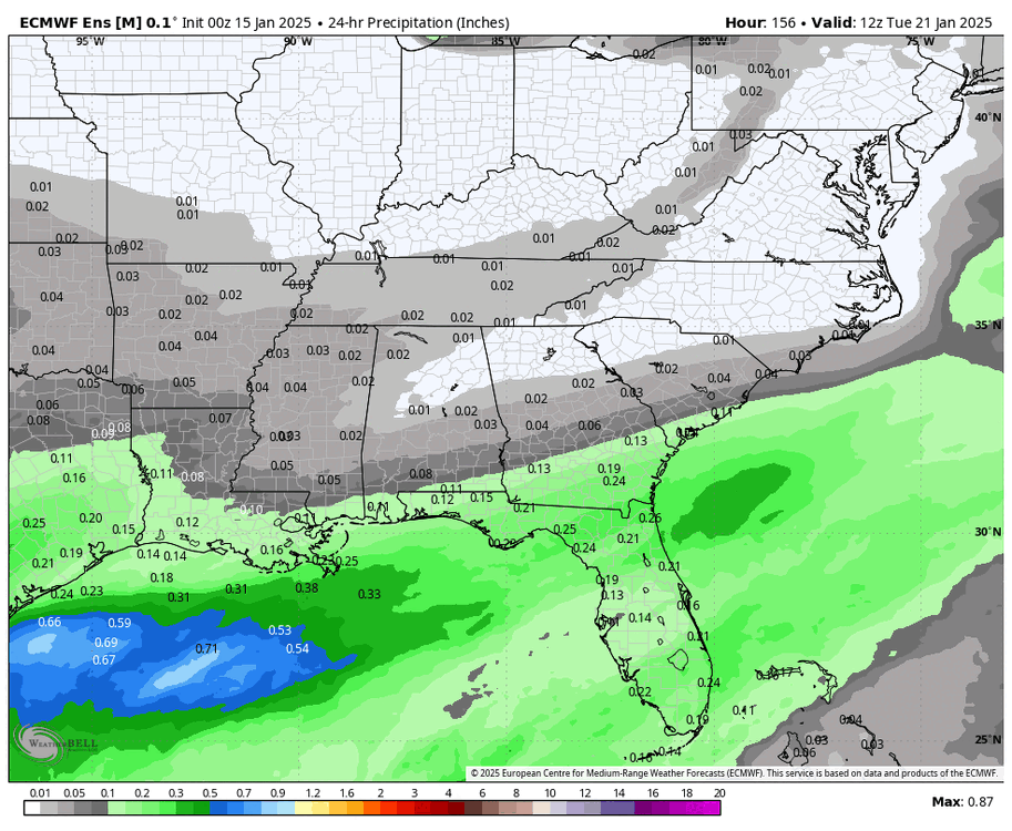
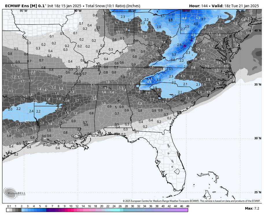
Similar story on the EPS, although across fewer runs because the mid cycle runs being only 144 hours.
-
I wouldn't say there is no NW trend showing but it certainly isn't as aggressive as usual. Despite the run to run variance of the OP GFS, the GEFS is clearly trending north with the precip for the early week threat.

-
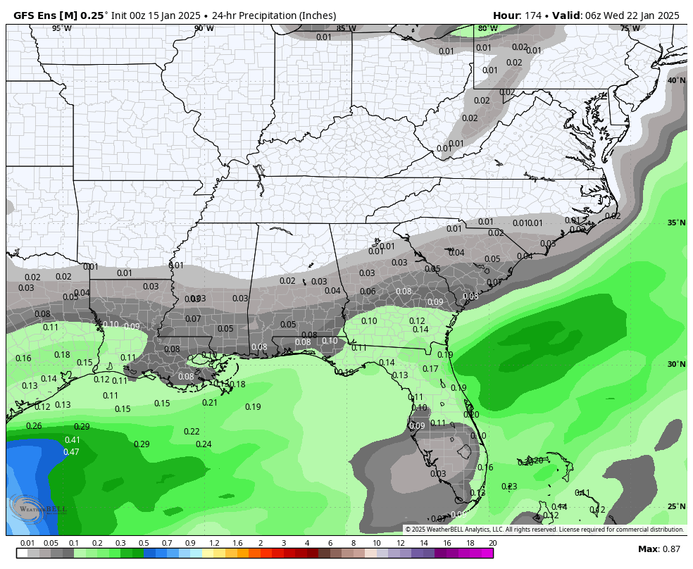
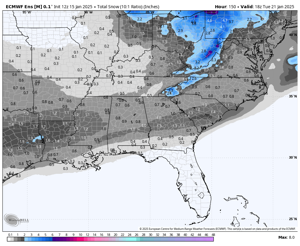
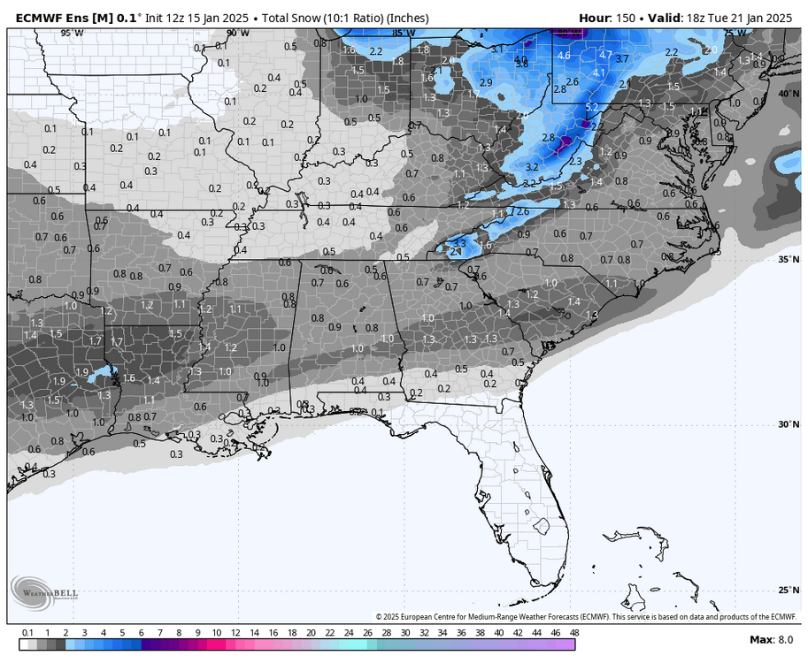
18z EPS Old 12z run. Keep in mind as well that because of the hr144 cutoff the event is still underway when this stops, otherwise totals would be even higher.
-
This for sure. I feel like we started tracking last weeks threat window shortly after Christmas. I think I'm still trying to catch up on sleep from all the last minute model chaos from that one.
-
We went through the dry suppressed look on the ensembles last time too. Give it time and see if the cold push actually verifies to the extent being shown. More often than not it moderates with time which also tends to pull the moisture back north. We should only be signal hunting at this range, and cold air looks to be around with moisture in the Gulf. Time to play the waiting game again.