chris624wx
-
Posts
277 -
Joined
-
Last visited
Content Type
Profiles
Blogs
Forums
American Weather
Media Demo
Store
Gallery
Everything posted by chris624wx
-

Mid to Long Range Discussion ~ 2022
chris624wx replied to buckeyefan1's topic in Southeastern States
Really hope we can keep the low a little farther off Hatteras. Don't want to have to worry about mixing in SE VA. Every storm so far this winter has been inland. Give me this one haha But loving the possibilities this far out. Hopefully we can reel it in! -
Yeah, ideally we'd like the low to track somewhere between Gainesville, FL and Orlando for all snow in the ATL-AHN corridor. This one definitely isn't taking that track, at least so far.
-
Hoping we can get something substantial in south Hampton Roads. Both Mid-Atlantic storms have gone north of us these past 2 weeks. We did get a hour or so of light to moderate snow back on the 3rd that actually tried to stick, but it didn't really do much.
-
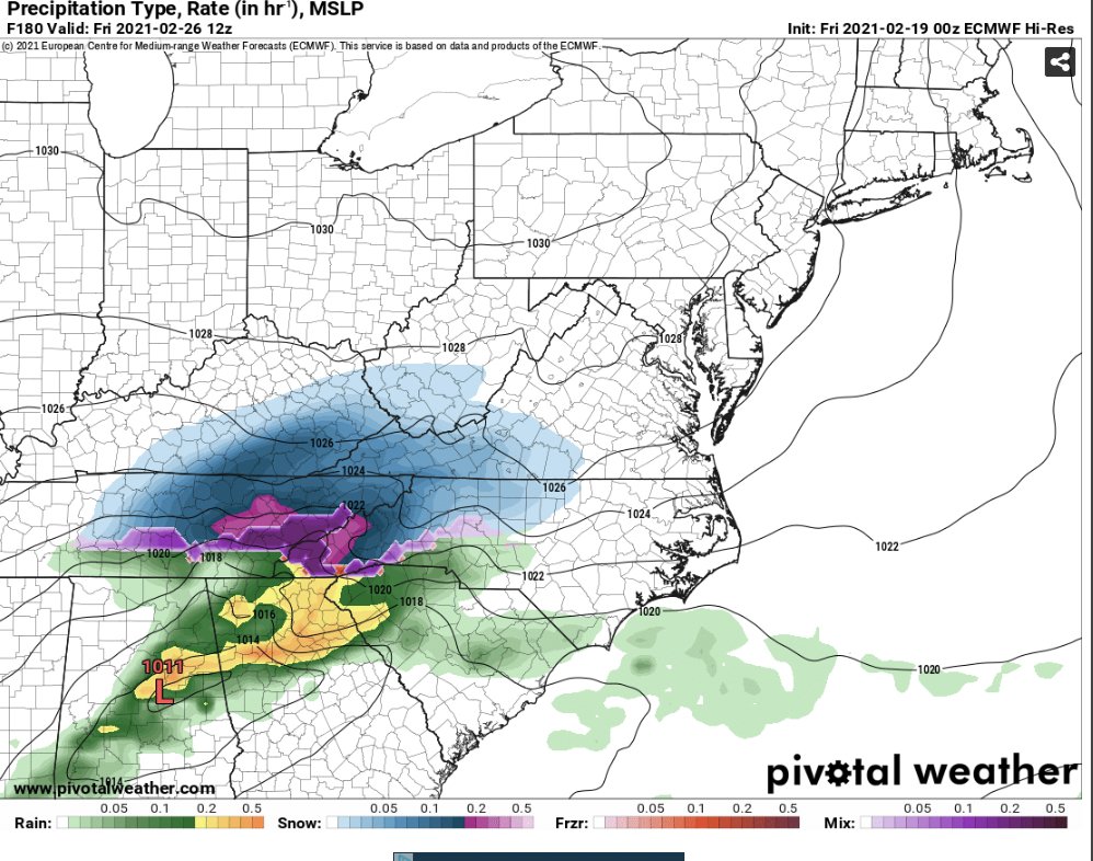
00z Euro still has the storm but it goes from looking great to meh, probably because the High is in the Great Lakes area andmore CAD-y than the GFS, which has the High still over the Midwest during the height of the storm.
-
Yes, I'll take this, and then gladly accept the pollen season!
-
V16 Suppressed
-
00z Euro wants to have some fun with the late week storm now too!


-
The most snow I've ever seen is Jan 2011 in Athens, GA. 8.8 inches. I'm in Norfolk, VA now. That would be INSANE haha
-
Sign me up!!!
-
Do not like lol
-
I'll take that and run here in Norfolk. Too bad every other model is a great degree drier haha
-
NWS Wakefield just put this out on twitter
-
haha yeah, very true. Not all that great for Hampton Roads. I guess we'll see how long V16/RGEM string me along!
-
12z Euro isn't really an improvement whatsoever, maybe even a bit worse for Thursday...
-
Yeah, 12z Euro and 18z GFS have been somewhat discouraging but 18z NAM was decent so???? Hopefully we'll have a better understanding by 12z/0z tomorrow.
-
Wow! Let me lock that in for Norfolk!
-
00z CMC a good hit for much of southern VA
-
Ummmm how do I cash this in for Norfolk/VB????
-
Just catching up with the 12z suite. Wow, if we can get that backside deformation zone the GFS showing in Hampton Roads, that'd be sweet. So hard to have to rely on those though.
-
hmm pretty decent back end snow for Hampton Roads as the low wraps up and departs off the coast. I would definitely take that and run with it!
-
Not much doing for SE VA on the 00z Euro. Like the 00z GFS the low just slides out to sea. This is my first full winter here but I'm pretty confident in saying that's not the track you want the low to take to get snow in Hampton Roads haha
-
Not as amped this run. Wish it would wrap up and go up the coast instead of OTS.
-
Need the low on 18z GFS about 50 miles more to the SE to get Norfolk/VB in on the Virginia fun haha
-
Missing earlier runs that had a more favorable low track for the Hampton Roads area. Still a lot of intrigue though!
-
Pretty positive this is going to bust for Norfolk. Nothing even accumulating yet. Frustrating.