chris624wx
-
Posts
277 -
Joined
-
Last visited
Content Type
Profiles
Blogs
Forums
American Weather
Media Demo
Store
Gallery
Everything posted by chris624wx
-

Richmond Metro/Hampton Roads Area Discussion
chris624wx replied to RIC Airport's topic in Mid Atlantic
What a crazy storm to track! Hard to believe that I was completely not enthused about it at the end of last week, and then we gradually trended toward being in the bullseye. Sorry for everyone inland who saw the storm move to the SE through the week. Hoping you get another snow event this season (if you want one!) -
Richmond Metro/Hampton Roads Area Discussion
chris624wx replied to RIC Airport's topic in Mid Atlantic
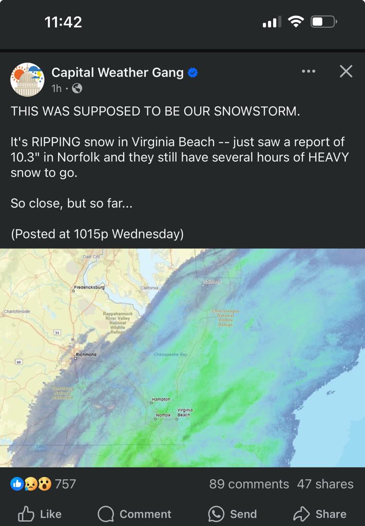
Right around 10" in between Ghent and Downtown Norfolk! What a storm! I've officially just witnessed my top snowstorm. The previous one was when I was in college at UGA in January 2011. The Athens Airport officially record 8.8" in that storm. Congrats to all who cashed in! This will be one we talk about for a while here in Hampton Roads. Now, bring on the pollen and 70°F! [emoji23] -
Richmond Metro/Hampton Roads Area Discussion
chris624wx replied to RIC Airport's topic in Mid Atlantic

-
Richmond Metro/Hampton Roads Area Discussion
chris624wx replied to RIC Airport's topic in Mid Atlantic
Looks like we're going to wind down here in Norfolk pretty soon. One last band pushing through now. I'll go out and measure once that passes! Excited to see what I record! -
Richmond Metro/Hampton Roads Area Discussion
chris624wx replied to RIC Airport's topic in Mid Atlantic
Absolutely puking snow in Norfolk right now! -
Richmond Metro/Hampton Roads Area Discussion
chris624wx replied to RIC Airport's topic in Mid Atlantic
Mesoscale Discussion 0118 NWS Storm Prediction Center Norman OK 1208 PM CST Wed Feb 19 2025 Areas affected...Portions of northern/northeast North Carolina into southeast Virginia Concerning...Heavy snow Valid 191808Z - 192315Z SUMMARY...Snowfall rates around 1 in. per hour are possible within a snow band in parts of northeast North Carolina and southeast Virginia. Immediate coastal areas could see slightly higher rates. DISCUSSION...As mid-level ascent continues to increase across the Mid-Atlantic this afternoon, a coastal trough is expected to deepen offshore. By the evening, a deeper surface low should be present off the coast from the Carolinas. This process should promote low/mid-level frontogenesis across parts of the region. This already appears to be occurring in northern/northeast North Carolina into southeast Virginia. Wakefield, VA ASOS has reported heavy snow within the last 30-45 minutes. This band should continue to translate northeastward through the afternoon into the evening. Moderate to heavy snowfall is probable within this band with overall rates near 1 in. per hour anticipated. Some areas near the immediate coast may see slightly higher rates or at least longer duration snow as the frontogenetic lift should be maximized in these areas. Snowfall intensity will eventually decrease by late evening into Thursday morning. With southern extent, towards central North Carolina, more of a mix of wintry precipitation is possible along the edge of the snow band as there will be greater influence from the low/mid-level warm nose. -
Richmond Metro/Hampton Roads Area Discussion
chris624wx replied to RIC Airport's topic in Mid Atlantic
GOM? What's that? ..........I kid -
Richmond Metro/Hampton Roads Area Discussion
chris624wx replied to RIC Airport's topic in Mid Atlantic
There it is! 475 FXUS61 KAKQ 182032 AFDAKQ AREA FORECAST DISCUSSION National Weather Service Wakefield VA 332 PM EST Tue Feb 18 2025 .SYNOPSIS... A significant winter storm will impact the area from Wednesday through Thursday. Dry but very cold weather is expected Thursday night. Temperatures will moderate through the weekend, while dry conditions prevail. && .NEAR TERM /UNTIL 6 AM WEDNESDAY MORNING/... As of 332 PM EST Tuesday... Key Message: - Dry tonight with lows mainly in the 20s, as Arctic high pressure extends to the SE. A quiet night is on tap for the local area ahead of tomorrow's winter storm. A strong high is centered over the Northern Plans and Southern Canada, with ridging extending through our area. The pressure gradient is relatively weak except for across the Eastern Shore. Winds are generally out of the northeast, with some locations seeing variable wind directions, and speeds are at or below 10 mph inland. Winds of 10 to 15 mph with gusts of 20 to 25 mph are being measured on the Eastern Shore. GOES Visible highlights a layer of thin upper-clouds over portions of our forecast area. Temperatures are in the 40s in most communities, with communities in the Eastern Shore still sitting in the 30s. Tonight, a northern stream shortwave will track eastward towards our area and cloud cover will increase and thicken in response. Precipitation associated with this shortwave will remain west of our area before ramping up tomorrow. Temperatures will drop into the 20s, so another chilly night is in the forecast. && .SHORT TERM /6 AM WEDNESDAY MORNING THROUGH FRIDAY NIGHT/... As of 332 PM EST Tuesday... Key Messages: - Forecast confidence continues to increase for a significant winter storm to impact southeast portions of the area Wednesday into Thursday. - Winter Storm Warnings are in effect for a majority of the forecast area, with Winter Weather Advisories in effect for the northernmost counties including Dorchester A northern stream shortwave will approach the area on Wednesday morning. An overrunning band associated with this feature will reach the northern half of the forecast area tomorrow morning between 8-11 am. A southern stream shortwave will be tracking just to our south by mid-afternoon tomorrow, which is when snowfall rates will really begin to ramp up. There will be a period where there is only moderate snowfall across the northern and central portions of our area before the northern stream shortwave transfers its energy to the southern one. As this occurs, conditions especially across SE VA and NE NC will deteriorate rapidly. A strong f-gen band looks to set up by tomorrow afternoon/tomorrow evening over this area as a developing low off of the SE coast begins to move northeastwards, leading to intense snowfall rates (1-2" per hour) and rapid accumulations. Confidence in snowfall totals in the SE forecast area is high, but snow totals farther north still remain somewhat in question even this close to the event. The 12Z NAM is suggesting much higher snow totals farther north and inland, which would require the low to track much closer to the coast. This is a far outlier and has not been incorporated into our forecast. Travel will be very difficult for the Wednesday evening and Thursday morning commutes across all of the forecast area, so stay off the road if possible. Thursday morning will provide another burst of snow on the back end of the system as a strong mid/upper low dives southeastward across the Mid-Atlantic. While the mid and upper-levels will have started to dry out, moisture will remain in place within the snow growth zone through around midday. Temperatures will be in the 20s across all of the forecast area, so snow ratios will be quite high, leading to a light and fluffy snow. A quick half-inch to an inch is possible during this time in some locations. Snow Totals... The forecast has remained roughly the same since this morning's update. SE VA and NE NC along with the VA portion of the Eastern Shore still remain the target of the highest snow totals, where 5- 10" are expected, with locally higher amounts possible. Winter Storm Warnings remain in effect for these areas. While there is still some uncertainty in areas around the RIC Metro and north, there is enough confidence in totals reaching Winter Storm Warning Criteria (4+") that a Warning has been issued for the Farmville-Richmond- Tappahannock-Salisbury area where 4-6" are forecast. Louisa to Cambridge has been placed in a Winter Weather Advisory, with snow totals between 2-4" possible in these areas. Light ice accumulations are forecast for a small portion of NE NC near the Albemarle Sound. Thursday Afternoon through Saturday Morning... After the end of the snow late morning into early afternoon Thursday, winds will pick up in earnest especially along the coast and on the Eastern Shore. This is due to the the tightening gradient between the low in the western North Atlantic and a strong high over the Plains. This could lead to some issues with blowing snow, especially since the last round of snow will be light and easily moved around. Have maintained mention of blowing snow in the coastal areas and Eastern Shore through Thursday evening. Very cold temperatures are expected Thursday night, with lows plummeting into the teens to lower 20s. These frigid lows, combined with the elevated winds, will likely lead to single digit wind chills. Cold Weather Advisories may be required for a significant portion of the local area. As the low moves further offshore Thursday night into Friday, the gradient will begin to relax. The aforementioned high will gradually shift eastward and finally settle across our area on Friday night into early Saturday. With high pressure and dry air dominating the region Thursday afternoon through Saturday morning, no precipitation is expected during this time. Temperatures will slowly start to moderate somewhat beginning Friday and highs will peak in the upper 30s to lower 40s. Low temperatures Friday night will drop back into the teens to lower 20s, with radiational cooling expected as winds slacken further and cloud coverage remains minimal. && -
Richmond Metro/Hampton Roads Area Discussion
chris624wx replied to RIC Airport's topic in Mid Atlantic
Waiting for a new AFD from AKQ. They pushed one out half an hour ago but it wasn't updated. -
Richmond Metro/Hampton Roads Area Discussion
chris624wx replied to RIC Airport's topic in Mid Atlantic
I think because this isn't going to be a complete phase, some of the energy is being left upstream so this Upper Level Low will rotate through the region as the main surface low departs. It should have enough lift associated with it to spark some scattered snow showers. -
Richmond Metro/Hampton Roads Area Discussion
chris624wx replied to RIC Airport's topic in Mid Atlantic
Hoping we can all cash in! -
Richmond Metro/Hampton Roads Area Discussion
chris624wx replied to RIC Airport's topic in Mid Atlantic
Allan Huffman's latest map -
Richmond Metro/Hampton Roads Area Discussion
chris624wx replied to RIC Airport's topic in Mid Atlantic
-
Richmond Metro/Hampton Roads Area Discussion
chris624wx replied to RIC Airport's topic in Mid Atlantic
Goodness. Kind of glad I'm in a 3rd story apartment haha -
Richmond Metro/Hampton Roads Area Discussion
chris624wx replied to RIC Airport's topic in Mid Atlantic
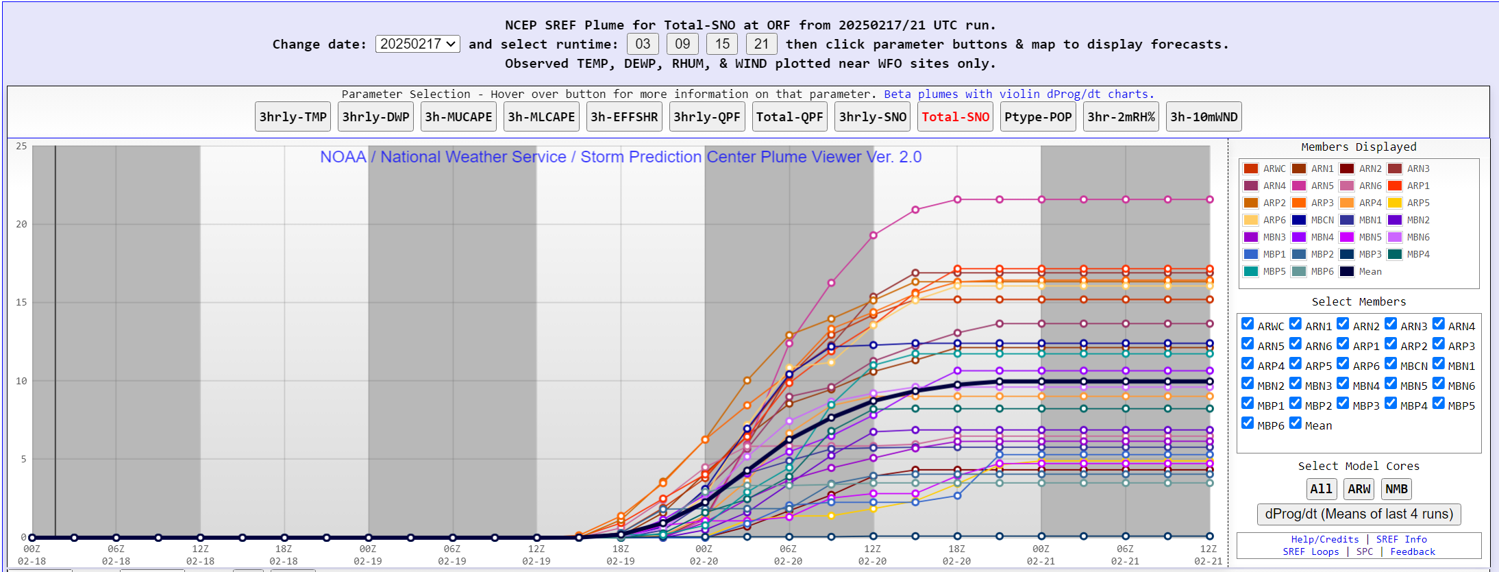
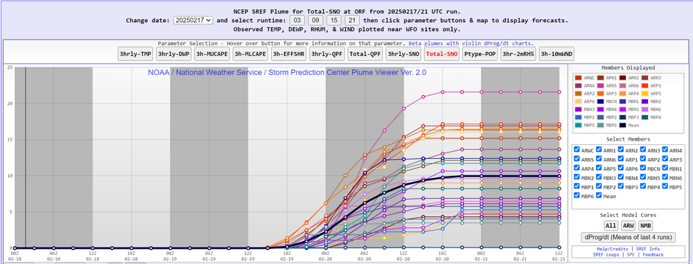
Potentially a top 10 snowfall for ORF if some of the modeling is correct. Will be interesting to see how it shakes out.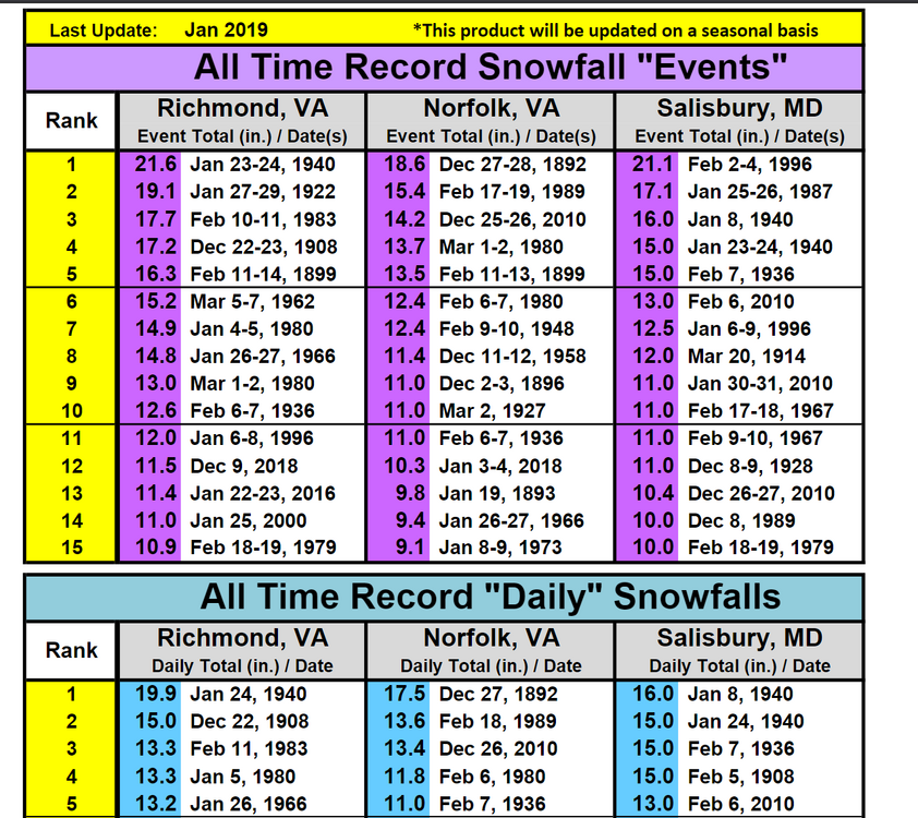
-
Richmond Metro/Hampton Roads Area Discussion
chris624wx replied to RIC Airport's topic in Mid Atlantic
GFS showing some deformation banding in Southside HR as the low pulls away too! -
Richmond Metro/Hampton Roads Area Discussion
chris624wx replied to RIC Airport's topic in Mid Atlantic
From AKQ's new AFD: 12z/17 operational models and their respective ensembles (GFS/ECMWF/Canadian) continued a solution showing lesser phasing between the southern stream system and the trailing potent northern stream mid-level trough. This drives a general S-SE trend with southern stream system and subsequent developing low pressure, with lower snow accumulations over far northern portions of the area (essentially RIC northward). Overall, forecast confidence is steadily increasing for a significant winter storm across our region Wednesday into Thursday. Ensemble probabilities have similarly settled over central and SE VA with 4+" probs (60-80+% from RIC southeast), with 6+" probs 50-70% from RIC Metro and 70-90% over Hampton Roads and southside into NE NC N of US-158. Notably 4 and 6" probs have lowered substantially (20-50% and 20-30%, respectively) above a FVX to RIC to SBY line. Precipitation Timing and Impacts... Precip spreads in from west to east through Wednesday morning, as strong WAA aloft slides across the region. Given the very cold air in place, this will set the stage for a broad swath of accumulating snows across the region. While the overall QPF has lowered across the northwestern half of the area, the initial slug of overrunning moisture (290-300 k SFCs) across the northern half of the area could well provide a strong, quick burst of snow over the NW-third of the area Wed morning into Wed afternoon, which could quick make for treacherous traveling conditions Wed morning into the afternoon across the RIC metro. Given expected higher SLRs on the preferred EPS/GEPS blend, the higher SLR will help "compensate" for the lower QPF to a degree for the actual snowfall forecast. Farther south, most of the QPF/winter wx is expected to come from 18z Wednesday through Thursday morning. The maxima for snow at this time is expected to occur along a developing deformation axis and colocated with f-gen forcing driving moisture into the DGZ, impacting (primarily) much of the Hampton Roads area and the eastern shore. Snow Totals... Given subsidence and rapid drying aloft expected from SW to NE late Wed into Thursday, expect a rather sharp gradient to snow totals, along with a rather abrupt end to snow Wed night and early Thursday afternoon. A Winter Storm Watch has been raised for Wednesday into Thursday for our entire area. Snowfall accumulations are on the order of 3-6" across MD and the VA northern neck, with 4-8" across the RIC metro into south central VA. Higher totals at this time appear to occur along that pivoting deformation band on the back side of the departing low, with 5-10" of snow forecast. Given the colder, general SE trend, ice accumulations across our area figure to be quite low. That said, the 12z/17 NAM still has a decent corridor of mixed precip across the far southern portions of our area across interior NE NC. We have maintained some ice accumulation in these areas but kept totals aob 0.10". Thursday/Thursday night... Shear axis associated with the northern stream shortwave crosses the region on Thursday, and will quite possible set off another round of light snow showers as it crosses, with additional minor snow accumulations possible. Cold high pressure builds across the region as precip exits offshore on Thursday evening. Lows Thursday night will be cold but specific values will depend heavily on where the axis of heaviest snow falls, with highs in the upper 20s to low 30s and lows likely to be in the lower to middle teens. -
Richmond Metro/Hampton Roads Area Discussion
chris624wx replied to RIC Airport's topic in Mid Atlantic
That makes me feel better -
Richmond Metro/Hampton Roads Area Discussion
chris624wx replied to RIC Airport's topic in Mid Atlantic
Wow...that's so far NW than most of the modeling! -
Richmond Metro/Hampton Roads Area Discussion
chris624wx replied to RIC Airport's topic in Mid Atlantic
788 WWUS41 KAKQ 171939 WSWAKQ URGENT - WINTER WEATHER MESSAGE National Weather Service Wakefield VA 239 PM EST Mon Feb 17 2025 MDZ021>025-VAZ075>078-085-521-522-180345- /O.NEW.KAKQ.WS.A.0005.250219T1100Z-250220T2300Z/ Dorchester-Wicomico-Somerset-Inland Worcester-Maryland Beaches- Westmoreland-Richmond-Northumberland-Lancaster-Middlesex-Western Essex-Eastern Essex- 239 PM EST Mon Feb 17 2025 ...WINTER STORM WATCH IN EFFECT FROM WEDNESDAY MORNING THROUGH THURSDAY AFTERNOON... * WHAT...Heavy snow possible. Total snow accumulations between 3 and 6 inches possible. Winds could gust as high as 35 mph. * WHERE...Portions of southeast Maryland and east central and eastern Virginia. * WHEN...From Wednesday morning through Thursday afternoon. * IMPACTS...Travel could be very difficult. The hazardous conditions could impact the Wednesday morning and evening commutes. PRECAUTIONARY/PREPAREDNESS ACTIONS... Monitor the latest forecasts for updates on this situation. && $$ NCZ012>017-030>032-102-VAZ084-086-089-090-092-093-095>100-523>525- 180345- /O.NEW.KAKQ.WS.A.0005.250219T1100Z-250220T2300Z/ Northampton-Hertford-Gates-Pasquotank-Camden-Western Currituck- Bertie-Chowan-Perquimans-Eastern Currituck-Gloucester-Mathews- Surry-James City-Southampton-Isle of Wight-Norfolk/Portsmouth- Suffolk-Chesapeake-Virginia Beach-Accomack-Northampton-York- Newport News-Hampton/Poquoson- 239 PM EST Mon Feb 17 2025 ...WINTER STORM WATCH IN EFFECT FROM WEDNESDAY MORNING THROUGH THURSDAY AFTERNOON... * WHAT...Heavy mixed precipitation possible. Total snow accumulations between 5 and 10 inches and ice accumulations of up to one-tenth of an inch possible. Winds could gust as high as 35 mph. * WHERE...Portions of northeast North Carolina and eastern and southeast Virginia. * WHEN...From Wednesday morning through Thursday afternoon. * IMPACTS...Travel could be very difficult. The hazardous conditions could impact the Wednesday morning and evening commutes. PRECAUTIONARY/PREPAREDNESS ACTIONS... Monitor the latest forecasts for updates on this situation. && $$ VAZ048-060>062-064>069-079>083-087-088-509>520-180345- /O.NEW.KAKQ.WS.A.0005.250219T1100Z-250220T2300Z/ Fluvanna-Prince Edward-Cumberland-Goochland-Caroline-Mecklenburg- Lunenburg-Nottoway-Amelia-Powhatan-Brunswick-Dinwiddie-Prince George-Charles City-New Kent-Greensville-Sussex-Western Louisa- Eastern Louisa-Western Hanover-Eastern Hanover-Western Chesterfield-Eastern Chesterfield (Including Col. Heights)- Western Henrico (Including the City of Richmond)-Eastern Henrico- Western King William-Eastern King William-Western King and Queen- Eastern King and Queen- 239 PM EST Mon Feb 17 2025 ...WINTER STORM WATCH IN EFFECT FROM WEDNESDAY MORNING THROUGH THURSDAY AFTERNOON... * WHAT...Heavy snow possible. Total snow accumulations between 4 and 8 inches possible. * WHERE...Portions of central, east central, north central, south central, and southeast Virginia. * WHEN...From Wednesday morning through Thursday afternoon. * IMPACTS...Travel could be very difficult. The hazardous conditions could impact the Wednesday morning and evening commutes. PRECAUTIONARY/PREPAREDNESS ACTIONS... Monitor the latest forecasts for updates on this situation. && $$ 05 -
Richmond Metro/Hampton Roads Area Discussion
chris624wx replied to RIC Airport's topic in Mid Atlantic
Winter Storm Watch just issued. -
Richmond Metro/Hampton Roads Area Discussion
chris624wx replied to RIC Airport's topic in Mid Atlantic
I think they're likely TO go up this afternoon. They mentioned in their early morning AFD holding off due to uncertainty. I guess we'll see how they feel about that when their afternoon package comes out. -
Richmond Metro/Hampton Roads Area Discussion
chris624wx replied to RIC Airport's topic in Mid Atlantic
Dang... -
Richmond Metro/Hampton Roads Area Discussion
chris624wx replied to RIC Airport's topic in Mid Atlantic
Don't have RIC's super zoomed in maps but yeah! -
Richmond Metro/Hampton Roads Area Discussion
chris624wx replied to RIC Airport's topic in Mid Atlantic
Okay that's more SE now than I'd like....