AMZ8990
-
Posts
1,227 -
Joined
-
Last visited
Content Type
Profiles
Blogs
Forums
American Weather
Media Demo
Store
Gallery
Everything posted by AMZ8990
-
Great run for sure, that’s what we’re looking for.
-
URGENT - WINTER WEATHER MESSAGE National Weather Service Memphis TN 138 PM CST Wed Jan 8 2025 ARZ009-018-026>028-035-036-048-049-058-MOZ113-115-MSZ001>017- TNZ001>004-019>022-048>055-088>092-091200- /O.UPG.KMEG.WS.A.0001.250110T0000Z-250111T1200Z/ /O.NEW.KMEG.WS.W.0001.250110T0000Z-250111T1200Z/ Clay-Greene-Craighead-Poinsett-Mississippi-Cross-Crittenden-St. Francis-Lee AR-Phillips-Dunklin-Pemiscot-DeSoto-Marshall-Benton MS-Tippah-Alcorn-Tishomingo-Tunica-Tate-Prentiss-Coahoma-Quitman- Panola-Lafayette-Union-Pontotoc-Lee MS-Itawamba-Lake-Obion- Weakley-Henry-Dyer-Gibson-Carroll-Benton TN-Lauderdale-Tipton- Haywood-Crockett-Madison-Chester-Henderson-Decatur-Shelby-Fayette- Hardeman-McNairy-Hardin- Including the cities of Fulton, Marks, Decaturville, Savannah, Paragould, Brownsville, Camden, Pontotoc, Union City, Selmer, Kennett, Tunica, Oxford, Lexington, Martin, Ripley TN, Corinth, Millington, Tiptonville, Marianna, Huntingdon, Dyersburg, Jackson, Jonesboro, Ripley MS, West Memphis, Helena-West Helena, New Albany, Forrest City, Corning, Paris, Blytheville, Olive Branch, Wynne, Memphis, Henderson, Piggott, Harrisburg, Covington, Collierville, Clarksdale, Senatobia, Germantown, Iuka, Booneville, Alamo, Dresden, Humboldt, Caruthersville, Parsons, Holly Springs, Tupelo, Southaven, Bolivar, Milan, Bartlett, Oakland, Ashland, Batesville, and Somerville 138 PM CST Wed Jan 8 2025 ...WINTER STORM WARNING IN EFFECT FROM 6 PM THURSDAY TO 6 AM CST SATURDAY... * WHAT...Heavy snowfall expected. Total snow accumulations between 4 and 6 inches. * WHERE...Portions of East Arkansas, North Mississippi, Southeast Missouri, and West Tennessee. * WHEN...From 6 PM Thursday to 6 AM CST Saturday. * IMPACTS...Travel could be very difficult. The hazardous conditions could impact the Friday morning and evening commutes. PRECAUTIONARY/PREPAREDNESS ACTIONS... If you must travel, keep an extra flashlight, food, and water in your vehicle in case of an emergency. The latest road conditions for the state you are calling from can be obtained by calling 5 1 1.
-
Nice! I have not had a chance to look at it yet, that sounds promising. Seems like our long-term outlook for January is trending in a favorable direction.
-
While we’re at it, Where’s @PowellVolz? I don’t think I’ve seen him post all winter.
-
Very light snow throughout the morning today in Memphis as well.
-
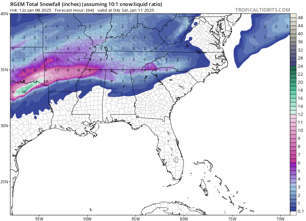
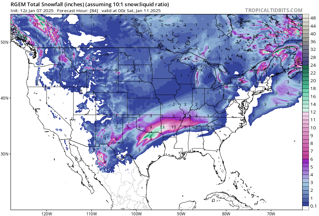
Widespread snowfall still coming down over most of the state at the 84hr mark on the RGEM, beefy run for sure.
-
Winter storm watches now up in Texas, Oklahoma, and Arkansas.
-
Seems like model continuity/trends to a similar outcome has gotten considerably better over the last 2 days. That’s definitely a trend I like to see.
-
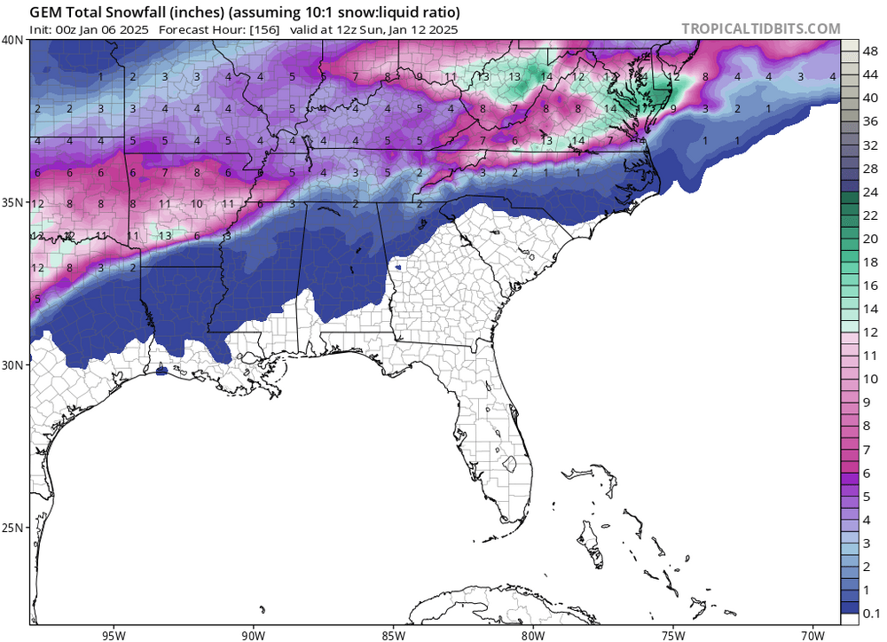
00z CMC onboard with the storm as well, looks like we have most of the models starting to align to a similar look/orientation.
-
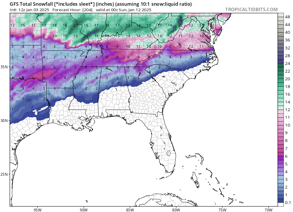
6z GFS snow totals for Friday/Saturday
-
I’ve got a good thunder and lighting show going on at the moment as this line of storms pushes through west Tn and north Ms. It’s eerily similar to the way things played out before our January snow last year.
-
Ah man, I am jealous! Enjoy your trip brother, winter park is my favorite out there. I like purgatory resort in Durango as well though.
-

-

-
I was looking at that also, those are some big numbers for sure! I used to live just north of Cincinnati in Middletown Ohio. It Looks like they’re expecting 6-10, that drive from Louisville to Cincinnati will be treacherous. That huge decline/hill at the ky/oh border as you come into Cincy from Kentucky is going to be a problem I would think.
-
Great stuff, Holston. Thanks for sharing
-
It did, no snow in key west that run. lol. In all seriousness though a couple more ticks north and that’s a huge storm for a lot of the forum. I’m with you on the ice too, I want no part of that!
-
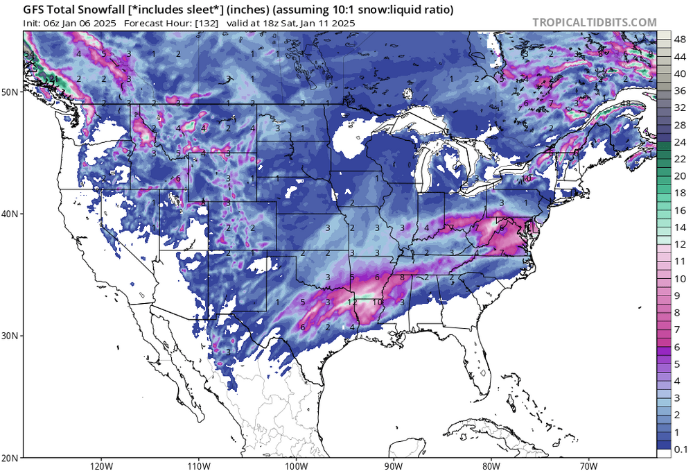
Most definitely, the strength of this cold shot is creating lots of volatility on the models from run to run. 6z GFS still wanting to take the low right through the midsouth. Big run for the Missouri/Indiana crew though. GFS is still trying to bring a 2nd system in on the 10th though, lots of potential there but HP kept it suppressed to the Deep South as it moved east.
-
Yes that is correct, from 6z Tuesday until 12z Wednesday the following week is below freezing the entire time. With wind chills included you guys would be looking at some negative temps if that were to verify.
-
I think I would toss this run of the GFS
-
Definitely seems like the Euro and GFS are on the same page about that 2nd week of January, both showing similar setups in that January 6th-10th timeframe. Long ways out but impressive to see nonetheless
-
Thanks Carv, and most definitely. I’m definitely looking forward to January and the potential we have there.