

Matthew70
-
Posts
843 -
Joined
-
Last visited
Content Type
Profiles
Blogs
Forums
American Weather
Media Demo
Store
Gallery
Everything posted by Matthew70
-

January Medium-Long Range Discussion
Matthew70 replied to Holston_River_Rambler's topic in Tennessee Valley
Sad with more heavy rains coming Friday. We needed the rain just came with a cost. -
January Medium-Long Range Discussion
Matthew70 replied to Holston_River_Rambler's topic in Tennessee Valley
Get better soon! -
January Medium-Long Range Discussion
Matthew70 replied to Holston_River_Rambler's topic in Tennessee Valley
The warm up really might be a warm up to above freezing. Lol. -
January Medium-Long Range Discussion
Matthew70 replied to Holston_River_Rambler's topic in Tennessee Valley
At least we are getting some much needed rains no matter the outcome. -
January Medium-Long Range Discussion
Matthew70 replied to Holston_River_Rambler's topic in Tennessee Valley
It is WSMV. -
Fall/Winter Banter - Football, Basketball, Snowball?
Matthew70 replied to John1122's topic in Tennessee Valley
I have not watched any of the game. Saw a score. Looks like there will be an asterisk by this title win plus chances are high it will be stripped along with many wins from cheating Harbaugh. He will leave MI in a mess. -
January Medium-Long Range Discussion
Matthew70 replied to Holston_River_Rambler's topic in Tennessee Valley
Curious what is the Icon model for? Also do they still use the NBM any? Think it was called National Blend Model. -
January Medium-Long Range Discussion
Matthew70 replied to Holston_River_Rambler's topic in Tennessee Valley
My anticipation gif is being shown. Lol! -
January Medium-Long Range Discussion
Matthew70 replied to Holston_River_Rambler's topic in Tennessee Valley
Love this forum. Great input & learning & lots of great laughs! This possible winter storm is now showing to possibly to begin Sunday afternoon in the western parts of the state. So for them it’s under 6 days!!! lol. What could go wrong! ALOT! -
January Medium-Long Range Discussion
Matthew70 replied to Holston_River_Rambler's topic in Tennessee Valley
Definitely not me!!! I was texted that from a source who is also not affiliated with channel 4! Lol. -
January Medium-Long Range Discussion
Matthew70 replied to Holston_River_Rambler's topic in Tennessee Valley
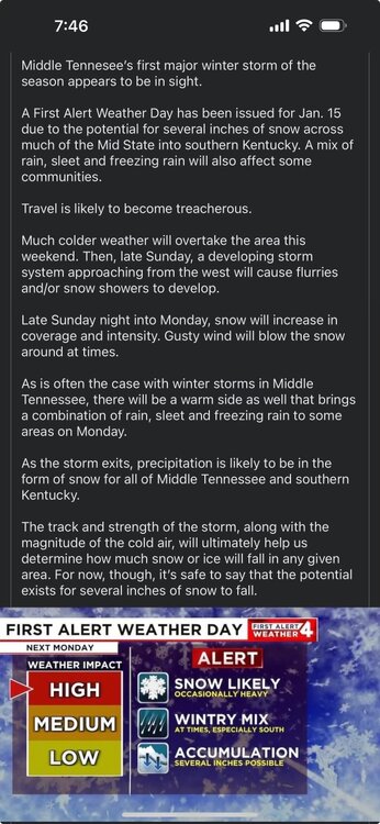
-
January Medium-Long Range Discussion
Matthew70 replied to Holston_River_Rambler's topic in Tennessee Valley
Been sometime since we have had one of those Alberta clippers. -
January Medium-Long Range Discussion
Matthew70 replied to Holston_River_Rambler's topic in Tennessee Valley
That’s some funny stuff there. I do hope that we all cash in though I do love that map. -
January Medium-Long Range Discussion
Matthew70 replied to Holston_River_Rambler's topic in Tennessee Valley
If it’s going to get that cold, I sure hope we do have snow to cover my new landscape so it does not get killed by the freezing temperatures. -
January Medium-Long Range Discussion
Matthew70 replied to Holston_River_Rambler's topic in Tennessee Valley
We get about another 150 mile push south with the colder air. ALL of TN will be in a sweet spot. One can hope for ALL of us. -
January Medium-Long Range Discussion
Matthew70 replied to Holston_River_Rambler's topic in Tennessee Valley
The CMC is it really ever right? Seems it’s the Hail Mary of models to me. Lol. Kinda like the Icon. Would be funny to see the DGEX clown maps these days. Those were always hilarious to see. -
January Medium-Long Range Discussion
Matthew70 replied to Holston_River_Rambler's topic in Tennessee Valley
You are correct in calling it an anafront. We have had a few of those in the past. Rare but happens occasionally. -
January Medium-Long Range Discussion
Matthew70 replied to Holston_River_Rambler's topic in Tennessee Valley
Right now I see this being a mixed bag for much of the forum area. Hopefully not all out ice storm. As usual I40 is the battle zone. I do believe the colder air will be further south. Models struggle with it as we all know. Fun to be able to track & chat about. -
January Medium-Long Range Discussion
Matthew70 replied to Holston_River_Rambler's topic in Tennessee Valley
I’m sure they meant Plateau. -
January Medium-Long Range Discussion
Matthew70 replied to Holston_River_Rambler's topic in Tennessee Valley
This is for the Friday system correct? NWS OHX is saying maybe up to 1” with snow showers Friday night. -
January Medium-Long Range Discussion
Matthew70 replied to Holston_River_Rambler's topic in Tennessee Valley
That’s the one I am also talking about. -
January Medium-Long Range Discussion
Matthew70 replied to Holston_River_Rambler's topic in Tennessee Valley
I could see this being a big surprise for much of the forum area. Now not saying it will be snow but ice could be the major issue. Having such cold air so close spells surprises many of the times for the mid south. If the LP is 150 miles more SE then look out. Either way we are going to get beneficial rains. -
January Medium-Long Range Discussion
Matthew70 replied to Holston_River_Rambler's topic in Tennessee Valley
I believe the Friday system is not done trending SE. Arctic air always presses further south than models show. -
January Medium-Long Range Discussion
Matthew70 replied to Holston_River_Rambler's topic in Tennessee Valley
I’d feel more comfortable if the GFS was not alone. Though ensembles do favor the GFS. Euro is one I like to have saying yes instead of no. -
January Medium-Long Range Discussion
Matthew70 replied to Holston_River_Rambler's topic in Tennessee Valley
Does he not think the MJO will rule the pattern?


