
Matthew70
-
Posts
863 -
Joined
-
Last visited
Content Type
Profiles
Blogs
Forums
American Weather
Media Demo
Store
Gallery
Everything posted by Matthew70
-
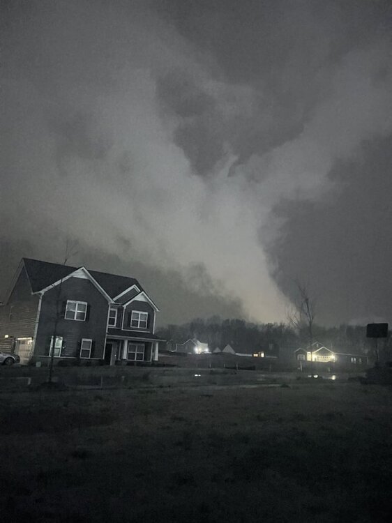
Very dire situation unfolding in Middle TN. Large intense violent tornado on ground. Long tracker.
-
Fairview tornado last night From Boyd
-
Definitely a light show. Strange thunder was not that loud. We had no hail or wind thankfully. Went right near us.
-
It appears to me it’s going to be west of TN.
-
Going to need a boat next week.
-
Boundaries! HARD PASS!
-
I hate nighttime tornadoes. Plus add in the LLJ. Just not good. Then we have middle of next weeks possible severe wx. YUCK!
-
Breaking: Storm Prediction Center just issued its FIRST EVER Level 2 tornado risk for the Pacific Northwest. Unprecedented weather setup brewing with potential supercells, large hail, and tornadoes threatening western Oregon and Washington today.
-
Well Sunday night is looking quite rough for west & middle. A powder keg just needing a match.
-
I am one that believes tornadoes follow a pattern or a rotation (no pun intended) of going thru certain area/landscapes. Examples here in the midstate state. Hendersonville/Gallatin is the north path. Dickson/Nashville/Lebanon (I40 path) Lobeville/Columbia/Springhill path. Lewisburg/Murfreesboro/Manchester path Waynesboro/Lawrenburg/Ethridge path I believe it’s only a matter of time during this rotation that Murfreesboro & the south paths see a tornado of significance come through. I know sounds crazy & ridiculous.
-
From Bobby Boyd
-
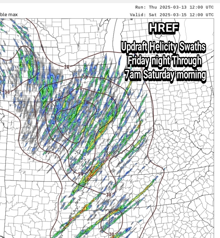
Well this one might have the necessary ingredients. We’ve been lucky so far but we are entering the time of year where it’s much easier to have severe wx.
-
From MEG on Sunday:"Deterministic runs ofboth the GFS and ECMWF paint SBCAPE values upwards of 1500 J/kgand 0-6 km bulk shear upwards of 55 kts in the aforementionedarea. This great thermodynamic environment will allow strong tosevere storms to produce damaging winds, large hail, and apossible tornado or two."
-
It’s really unbelievable what’s happening with this outbreak. I hope the cams are wrong about multiple waves of supercells tomorrow.
-
I believe it’s warranted. This system has a very high ceiling but also has potential bust. All the sources I’ve seen have said just that. Public will always have it’s typical can’t make happy no matter what. Many well educated & respected meteorologist are concerned. When Spann, Fred Gossage, and Andy say pay attention then it’s serious. They are not like Timmer who hypes every storm. Earlier I listened to the Nashville wx briefing. She was clear on its “boom” or “bust”. One thing really stood out to me what she said. “Being in an enhanced risk 3 days out is eye opening”. She made it clear that if the cap breaks tomorrow night then it’s going to be a rough 24 hours.
-
From Bobby Boyd.
-
If it sticks around. If it clears for a few hours. Then tighten your belt. It could get rough.
-
I saw where many are saying it’s the models having convective feedback. No idea if that is true & what it means.
-
Hey now no drawing a circle around my house! Tornadoes are not allowed!
-
As Spann says. “Nothing can compare to April 2011”. That’s a once every 30-40 years outbreak.
-
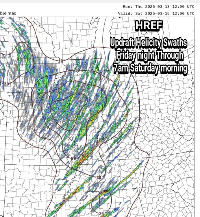
Do you think this is a west TN threat Friday night & an East TN threat Saturday afternoon? Skipping over middle?
-
Agree. I believe the mid state is going to see a lot of rain & thunderstorms but nothing more than that. Seems Nashville has its every few years long track tornado. Other than that no red letter day. The storm shield is stout.
-
I could see the SPC expanding the 30% at this time. I am afraid moisture return is going to be much more expansive.
-
Hopefully my daughter soccer showcase gets canceled or moved from Jackson MS to AL (not that it’s any better) but MS is a magnet for tornadoes. HARD PASS!
-
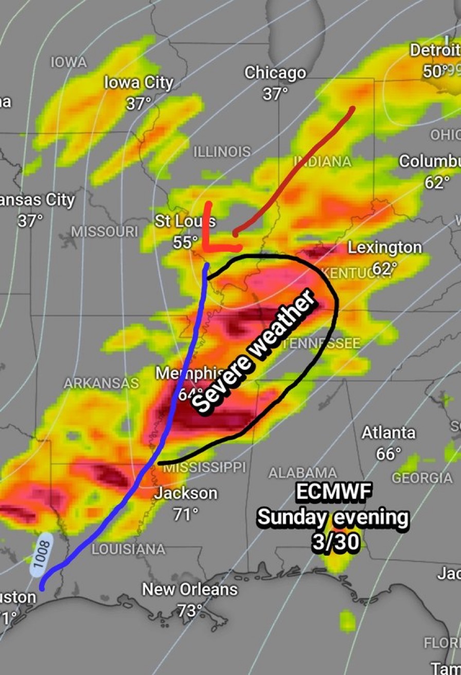
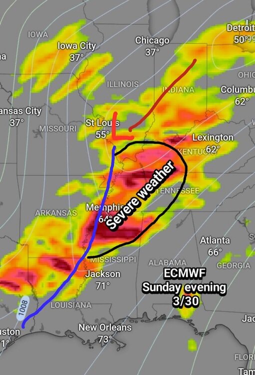
Interesting. American models are now saying threat is much lower. Will Euro models join the American models in that camp. Not sure why wx offices including SPC are in such a hurry to post graphs like this. If it was a winter storm they would wait till the last min.