MikeB_01
-
Posts
1,827 -
Joined
-
Last visited
Content Type
Profiles
Blogs
Forums
American Weather
Media Demo
Store
Gallery
Everything posted by MikeB_01
-

Western PA/Pittsburgh Winter 2021/22 Discussion
MikeB_01 replied to meatwad's topic in Upstate New York/Pennsylvania
If i had to take a guess at it, I would think the line of ZR is further north and west. The warm advection always wins around here. If the GFS is realized, then maybe we are looking a little rougher for the ZR in the metro. -
Western PA/Pittsburgh Winter 2021/22 Discussion
MikeB_01 replied to meatwad's topic in Upstate New York/Pennsylvania
The most notable thing form the 00z so far is the narrow band of HEAVY zr that is showing up consistently on the modeling. It has been clear on all so far. The position of that band will be a very rough patch for whoever is under it. -
Western PA/Pittsburgh Winter 2021/22 Discussion
MikeB_01 replied to meatwad's topic in Upstate New York/Pennsylvania
Yes. As the model continued, the GFS is maybe 25 miles SE of the HRRR with that nasty band of zr. 3k right in between the two. GFS would be a rough day for anyone in the metro and south -
Western PA/Pittsburgh Winter 2021/22 Discussion
MikeB_01 replied to meatwad's topic in Upstate New York/Pennsylvania
Changes through 36 hrs are pretty negligible -
Western PA/Pittsburgh Winter 2021/22 Discussion
MikeB_01 replied to meatwad's topic in Upstate New York/Pennsylvania
Early on (only thru 18 hr) looking a little more amped. -
Western PA/Pittsburgh Winter 2021/22 Discussion
MikeB_01 replied to meatwad's topic in Upstate New York/Pennsylvania
GFS is running... Lets see what happens. -
Western PA/Pittsburgh Winter 2021/22 Discussion
MikeB_01 replied to meatwad's topic in Upstate New York/Pennsylvania
I wonder if there is actually a site that can display that graphic. That would be interesting! -
Western PA/Pittsburgh Winter 2021/22 Discussion
MikeB_01 replied to meatwad's topic in Upstate New York/Pennsylvania
I still think that it is for the potential. HRRR is dropping more than 1" on ice on Beaver county with almost nothing in eastern AGC. Little tiny shifts make big differences here. -
Western PA/Pittsburgh Winter 2021/22 Discussion
MikeB_01 replied to meatwad's topic in Upstate New York/Pennsylvania
Winter Storm Watch: [WS.A] Potential for a blizzard, heavy snowfall, or ice storm within the next 18 to 48 hours. Issued when there is a 50% confidence or greater of at least 6 inches of snow over 12 hours, or at least 8 inches of snow over 24 hours, and/or a ¼ inch of ice. -
Western PA/Pittsburgh Winter 2021/22 Discussion
MikeB_01 replied to meatwad's topic in Upstate New York/Pennsylvania
3K is nearing the end of the run on TT. Its definitely better than the reg NAM. Cooler and def more interesting. Pretty rough on the FZR though -
Western PA/Pittsburgh Winter 2021/22 Discussion
MikeB_01 replied to meatwad's topic in Upstate New York/Pennsylvania
I think they keep it there because of the uncertainty in the forecast. We are talking about the FZR line at the edge of the county. Close call and a tough call -
Western PA/Pittsburgh Winter 2021/22 Discussion
MikeB_01 replied to meatwad's topic in Upstate New York/Pennsylvania
No way. All we are asking for is a little positive energy. No wishcasting, but some good positive vibes. We all understand the challenges for winter weather in this area. It is what it is. Lets enjoy the ride and laugh along the way -
Western PA/Pittsburgh Winter 2021/22 Discussion
MikeB_01 replied to meatwad's topic in Upstate New York/Pennsylvania
3K also has it significantly further south than the NAM --> At least so far in the run. Still waiting for it to run its course. -
Western PA/Pittsburgh Winter 2021/22 Discussion
MikeB_01 replied to meatwad's topic in Upstate New York/Pennsylvania
Man, every single storm, KPIT walks himself into a pile on. -
Western PA/Pittsburgh Winter 2021/22 Discussion
MikeB_01 replied to meatwad's topic in Upstate New York/Pennsylvania
Thats what I am saying. The NAM run just looked strange. The interesting thing about the 00z so far (and it has trended this way a little today) is that the storm appears more amped. Yesterday we saw a flattening of the system as a whole and today that ridge is popping just a little bit more. Interested to see what the other models do with that. -
Western PA/Pittsburgh Winter 2021/22 Discussion
MikeB_01 replied to meatwad's topic in Upstate New York/Pennsylvania
positive vibes people. Positive vibes -
Western PA/Pittsburgh Winter 2021/22 Discussion
MikeB_01 replied to meatwad's topic in Upstate New York/Pennsylvania
at least its interesting... Always nowcasting -
Western PA/Pittsburgh Winter 2021/22 Discussion
MikeB_01 replied to meatwad's topic in Upstate New York/Pennsylvania
I dont know... Somethings looks really off on that radar run of the HRRR. Like a force field bubble. The freezing line approaches and then doesnt advance for 12 straight hours.. Call me Rosey, but it looks strange to me. -
Western PA/Pittsburgh Winter 2021/22 Discussion
MikeB_01 replied to meatwad's topic in Upstate New York/Pennsylvania
I am with you -
Western PA/Pittsburgh Winter 2021/22 Discussion
MikeB_01 replied to meatwad's topic in Upstate New York/Pennsylvania
I say this, but you better believe that if the 18z was puking snow, I’d lock in that run in a heartbeat . -
Western PA/Pittsburgh Winter 2021/22 Discussion
MikeB_01 replied to meatwad's topic in Upstate New York/Pennsylvania
I never put any stock into the 18z runs. Just wait for the 00z and we will see what we have. . -
Western PA/Pittsburgh Winter 2021/22 Discussion
MikeB_01 replied to meatwad's topic in Upstate New York/Pennsylvania
found this. Thought it was nice to see the comparison between models and runs of models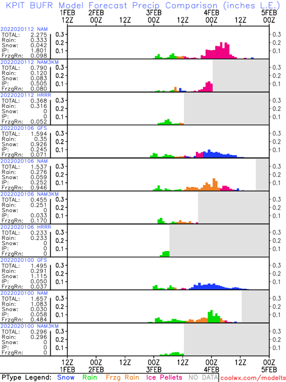
-
Western PA/Pittsburgh Winter 2021/22 Discussion
MikeB_01 replied to meatwad's topic in Upstate New York/Pennsylvania
They are definitely not canceling anything. 33° on one run of one model. HRRR is still out of its league with this amount of time to go. 18z NAM keeps the ice line close enough to the county for the watch to be maintained. -
Western PA/Pittsburgh Winter 2021/22 Discussion
MikeB_01 replied to meatwad's topic in Upstate New York/Pennsylvania
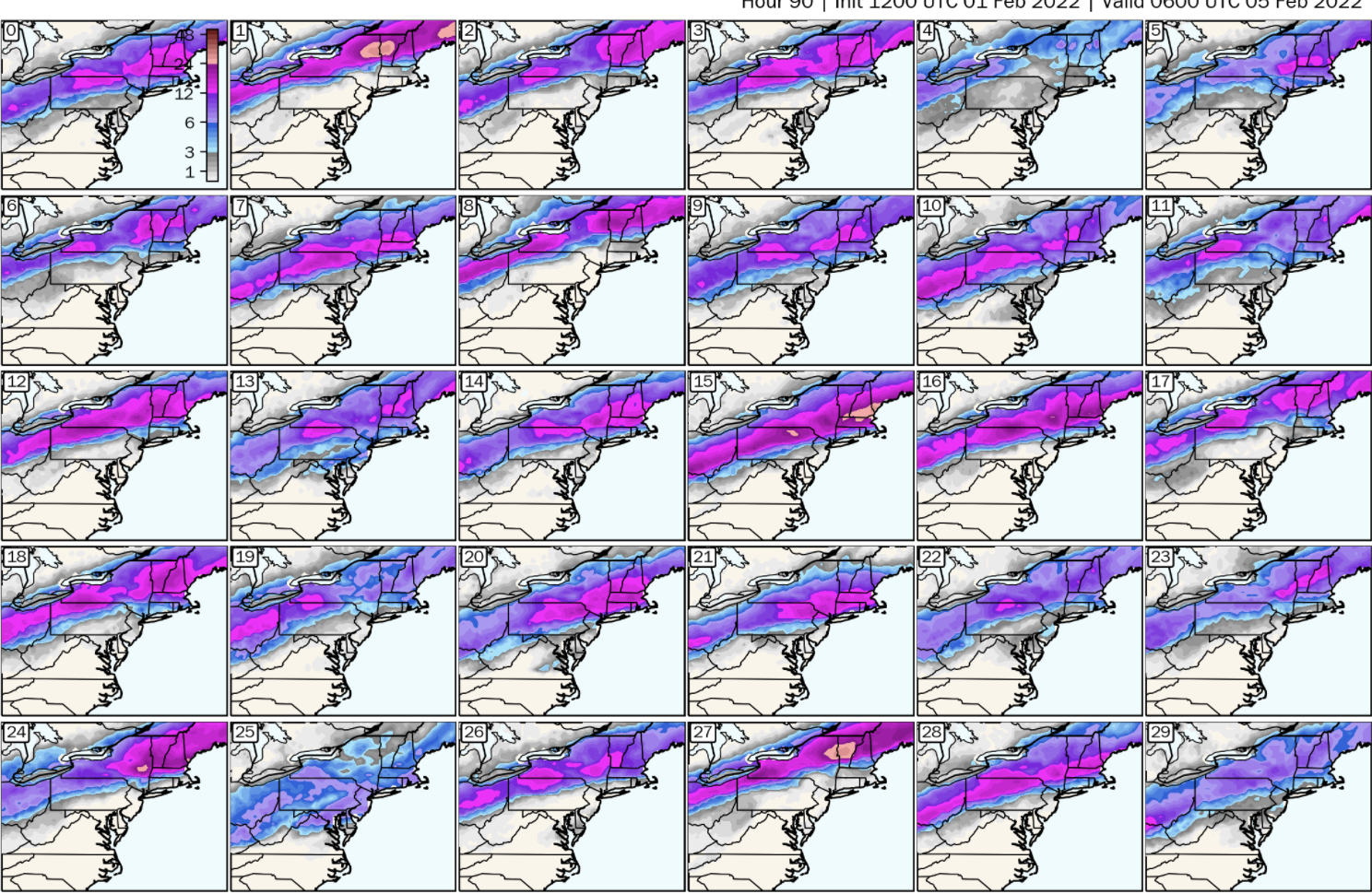
12z GEFS Panels
-
Western PA/Pittsburgh Winter 2021/22 Discussion
MikeB_01 replied to meatwad's topic in Upstate New York/Pennsylvania
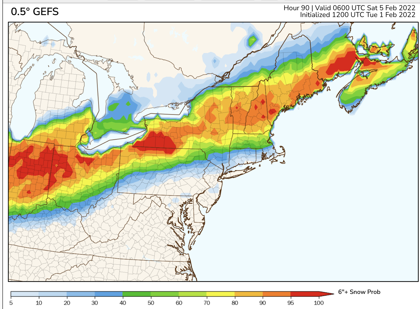
12z GEFS Prob of 6+"