

MikeB_01
-
Posts
1,827 -
Joined
-
Last visited
Content Type
Profiles
Blogs
Forums
American Weather
Media Demo
Store
Gallery
Everything posted by MikeB_01
-
 Extended HRRR has VERY minimal snow on the backside of the front. The precip dries out before dropping more than a dusting
 -
URGENT - WINTER WEATHER MESSAGE National Weather Service Pittsburgh PA 235 PM EST Wed Dec 21 2022 ...A STRONG WINTER STORM WILL CREATE MULTIPLE HAZARDS ACROSS THE REGION... PAZ007>009-013>016-020>022-029-031-073-075-WVZ001>004-012-021-509- 220345- /O.NEW.KPBZ.WC.A.0001.221223T1100Z-221224T1800Z/ Mercer-Venango-Forest-Lawrence-Butler-Clarion-Jefferson PA-Beaver- Allegheny-Armstrong-Washington-Greene-Westmoreland-Fayette- Hancock-Brooke-Ohio-Marshall-Wetzel-Marion-Monongalia- Including the cities of Grove City, Latrobe, Weirton, Kittanning, Murrysville, Punxsutawney, New Castle, Canonsburg, Fairmont, Ambridge, Franklin, Sharon, Ford City, Butler, Lower Burrell, Morgantown, Tionesta, Washington, Monessen, Monaca, Wellsburg, Brookville, Waynesburg, Wheeling, Oil City, Hermitage, Clarion, New Martinsville, Aliquippa, Moundsville, Greensburg, Uniontown, Pittsburgh Metro Area, Ellwood City, Beaver Falls, Follansbee, and New Kensington 235 PM EST Wed Dec 21 2022 ...WIND CHILL WATCH IN EFFECT FROM FRIDAY MORNING THROUGH SATURDAY AFTERNOON... * WHAT...Dangerously cold wind chills possible. Wind chills as low as 20 below zero. Wind gusts of 40 to 50 mph are expected Friday through Saturday afternoon. * WHERE...Portions of northwest, southwest, and western Pennsylvania. Portions of northern and the northern panhandle of West Virginia. * WHEN...From Friday morning through Saturday afternoon. * IMPACTS...The dangerously cold wind chills could cause frostbite on exposed skin in as little as 30 minutes. Strong winds could produce damage to trees and power lines, resulting in scattered power outages. Winds may gust over 40 mph Friday afternoon through Saturday evening. PRECAUTIONARY/PREPAREDNESS ACTIONS... Monitor the latest forecasts and warnings for updates on this situation.
-
Wind chill watch was just issued.
-
I always like the check the SREFs. Not the most reliable, but still fun to look at. Hovering right around 1" of snow. All falling with the passage of the front. The temps will be brutal by midday and not much change for 48 hours. Very impressive for December.
-
Yeah, NCEP saying GFS running about 30 minutes behind.
-
Pretty nice shift SE on the CMC
-
never trust a cut off low.
-
I don't think i have ever seen the flag come out this early. Come on guys. One run of one model. Stay in the game. The fact is that we are 6 days out and have a system in play. Lets watch for a few days
-
Fall 2022 Pittsburgh/Western PA Discussion
MikeB_01 replied to Ahoff's topic in Upstate New York/Pennsylvania
just for fun. Current weather in Buffalo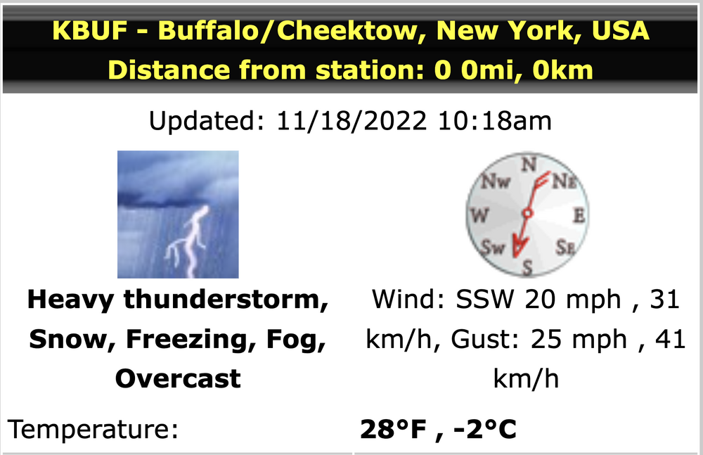
-
Fall 2022 Pittsburgh/Western PA Discussion
MikeB_01 replied to Ahoff's topic in Upstate New York/Pennsylvania
This slug of rain has me ready for a good thump of snow . -
Pittsburgh/Western PA Summer 2022 Discussion
MikeB_01 replied to Ahoff's topic in Upstate New York/Pennsylvania
Hot take: the GFS is garbage. . -
Pittsburgh/Western PA Summer 2022 Discussion
MikeB_01 replied to Ahoff's topic in Upstate New York/Pennsylvania
I’m ready at least for a little bit. I’m not looking for ton of rain, but a nice thunderstorm here and there would work wonders. I love landscape and gardening, this has been a tough stretch on my plants . -
Pittsburgh/Western PA Summer 2022 Discussion
MikeB_01 replied to Ahoff's topic in Upstate New York/Pennsylvania
Yes. HRRR runs after 18z yesterday really backed off of the rain west of the city. Everything forming south and east. Looks like that is holding true on radar . -
Pittsburgh/Western PA Summer 2022 Discussion
MikeB_01 replied to Ahoff's topic in Upstate New York/Pennsylvania
This is such a good website for data. I can never figure out how to work it. Thanks for the data . -
Pittsburgh/Western PA Summer 2022 Discussion
MikeB_01 replied to Ahoff's topic in Upstate New York/Pennsylvania
What a great picture of some mammatus. Don’t see that too often around here . -
Pittsburgh/Western PA Summer 2022 Discussion
MikeB_01 replied to Ahoff's topic in Upstate New York/Pennsylvania
I still have no clue how it didn’t rain in AGC . -
Pittsburgh/Western PA Summer 2022 Discussion
MikeB_01 replied to Ahoff's topic in Upstate New York/Pennsylvania
Serious question. How does the convection split like that? What is the inhibiting factor that is causing nothing in between two very impressive lines . -
Pittsburgh/Western PA Summer 2022 Discussion
MikeB_01 replied to Ahoff's topic in Upstate New York/Pennsylvania
Radar is starting to develop out in central Ohio. Looking a little more robust than the earlier runs of the models . -
Pittsburgh/Western PA Summer 2022 Discussion
MikeB_01 replied to Ahoff's topic in Upstate New York/Pennsylvania
It’s hot for sure. However, if the alternative is the 38° and rainy days we get in the middle of March, I’ll take this day please . -
Pittsburgh/Western PA Summer 2022 Discussion
MikeB_01 replied to Ahoff's topic in Upstate New York/Pennsylvania
93.0°and a 79.8° dew point on my PWS. Not the most accurate, but not that far off either. It’s scorching out there . -
Western PA/Pittsburgh Winter 2021/22 Discussion
MikeB_01 replied to meatwad's topic in Upstate New York/Pennsylvania
Back to rain in the south hills. It had transitioned to snow and sleet. At least in Bridgeville I have rain . -
Western PA/Pittsburgh Winter 2021/22 Discussion
MikeB_01 replied to meatwad's topic in Upstate New York/Pennsylvania
Waking up this morning and looking outside… . -
Western PA/Pittsburgh Winter 2021/22 Discussion
MikeB_01 replied to meatwad's topic in Upstate New York/Pennsylvania
The snow and cold will win out. The roads and other paved surfaces are resisting because of how warm it got today. Couple of hours and they will give in . -
Western PA/Pittsburgh Winter 2021/22 Discussion
MikeB_01 replied to meatwad's topic in Upstate New York/Pennsylvania
NWS doubling down... Love it. -
Western PA/Pittsburgh Winter 2021/22 Discussion
MikeB_01 replied to meatwad's topic in Upstate New York/Pennsylvania
guys, admittedly, i'm getting to the party late. But things look ok right now?

