MikeB_01
-
Posts
1,827 -
Joined
-
Last visited
Content Type
Profiles
Blogs
Forums
American Weather
Media Demo
Store
Gallery
Everything posted by MikeB_01
-
 SREFS over the last 4 runs --> Trending up. GEFS Plumes --> 3+ and has been trending up a little over the last few runs.
-
Canadian made some moves as well... Nothin big, but 2-3 days out, this is a nice trend. I think we would all just some snow falling at this point.
-
Honestly, its a nice trend. We are right on the line, but the 00z GFS showed some hints of bringing the energy back a little further west as well. So the NAM and the GFS are hinting at a slightly stronger LP that runs a little more inland and slower. Will need to watch, but its a nice to see. Hoping the Canadian comes in with a least a little move
-
00z suite is coming in this evening. Models are all over the place. So many different pieces they are trying to figure out. Long week of watching...
-
Sign me up for #8 .
-
I’d be content if I couldn’t see grass under the snow .
-
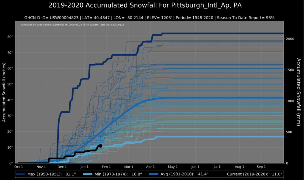
Found these maps out there. Pretty interesting to see where we are so far in snowfall. Not the bottom, but pretty damn close
-
I'm not ready to throw the towel just yet. February is climatologically the second snowiest month for W PA. Right now, the long term pattern (the active pacific and sub tropical jets) while they don't mean they are cold, they do mean that February should be active. All we need is a little wobble in the PV and then we might have the stage set. Would i be shocked if we had a below average season, no. But i also wouldn't be surprised if February (2nd - 3rd week) we at least got a few systems that can be players.
-
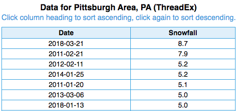
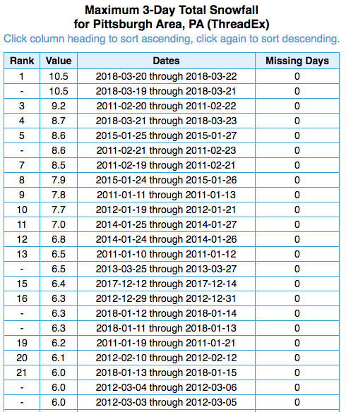
So this actually makes me sad. Since 01/01/2011 here are some stats We've had seven (SEVEN! --> Thats it!) single days that have 5.0" of snow or more. We've had 18 snowfalls of 6+" over a 3 day stretch (the data shows 23, but i eliminated duplicate storms over a different 3 day period). It was the only way i could think of to get close to what you wanted to see. 18 storms in 10 years. 1.8 storms a year of 6+" Unfortunately, though it seems like we haven't had that many -- trust me, i'm in the same mindset. NWS Pittsburgh says that climatologically we have two 5" storms a year. Sadly, we are in the right spot.
-
Took a look at the UL WV tonight. Can start to get an idea of all of the pieces and how they are working together. Also give you an idea about why this is probably going to end up warmer than what we need it to be.
-
Granted, the result didn't matter too much. The storm still ended up off to the north due to alot of the noise and congestion out in front of it, but i think this is a good step.
-
BIG changes on the NAM.
-
Anyone check the Canadian today? 12z is supposed to be on the newly upgraded supercomputer. https://dd.meteo.gc.ca/doc/genots/2020/01/17/NOCN03_CWAO_171911___36984 .
-
Models have always struggled with the environment around and under closed off H5 storms. Not sure the models have a good handle on this one yet. Definitely not saying this one ends up as a hit for us, but still think we need to see some development. Energy from the system is just now coming over the land and I think the 00z run tonight might be important for the movement of the trend. If it continues to show no snow, then we are where we usually are. However, I wouldn't be surprised to see some snow back on the map tonight. Regardless of what this storm does, no one, is getting 12+ from this storm. That includes anyone in the northeast. This pattern and its progressive nature just don't allow the storm to move slow enough to pile on some large numbers. Too fast
-
The 7th best analog for the 12z GFS is Feb 16-18 2003. I'd take it
-
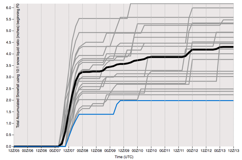
Damn. Day 7. Not sure what I want. Nice to see some pink on this map thats for sure
-
Sure seems like its right for the area, but something seems strange with the PType and surfaces temps of this run of the GFS. Plenty of vort, a closed off low H5, and no warm air in the upper or mid levels of the atmosphere. Seems odd that the surface would respond like it is depicted on this map. Maybe im wrong, just seems off. Anyway, still something to look at and hope for. At least we have a storm that is taking a pretty good path for us right now. Just need to the timing to be correct
-
EPS temps for next weekend... Cold air definitely not in place
-
Thought it was pretty cool to see this on the data from my PWS. When the first round came through, you can clearly see the evaporative cooling (around 3 am) and then the warm surge to where we are now.
-
I got a quick 1" this morning between 2:30 and 4:00 am. There was even a little sleet mixed in with that snow that feel at the tail end of that band this morinng. The second round has been all sleet.
-
I agree with the 1-2. I didn't like the 3" high mark they had. Here's hoping for the 4" surprise. Maybe the column saturates rapidly and we snow for 6 consecutive hours. I'll second you and put the positive vibes out there
-
beep... beep... beep... Back that truck on up. Was never quite sure why they were going with the higher amounts that they were. I feel like they sometimes forget how this area performs during snow systems.
-
Its been depicted on models for days, but we've stayed mostly out of it. I'll be watching to see the set up of the dry slot. That first wave and then the dry slot and then the main storm. The position of the dry slot and the duration will go a long way in to determining whether we get the low end or high end of the forecasted totals.
-
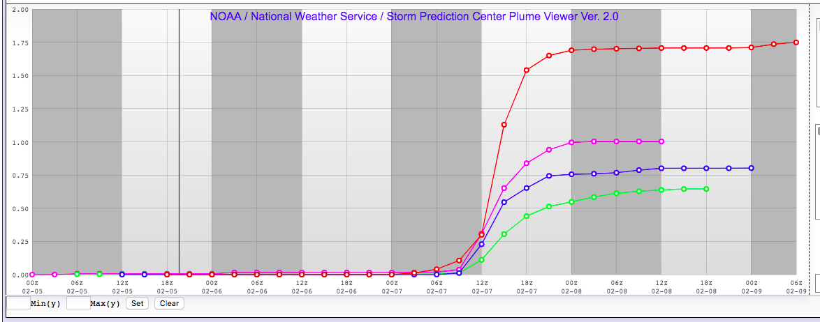
I was seeking and I found. Though it is a little old data --> 12z today. I did find the EPS data. I find it interesting that the 90% is up over 2" for KPIT. Just seems high to me. Maybe because the storm seems to be a little bit more zonal rather than amplified, we get a slightly slower change over than what we are used to. Maybe I am just wishing? Maybe i am crazy? Maybe I am seeing things because it is almost 1 am and I have been looking at the weather for the last 4 hours... Whatever it may be, I'm out. goodnight.
-
GFS continues to hang on to the cold air for longer. Not really how, but it seems like the high pressure that is moving in behind our system today is digging in hard. Not sure i buy it, but the GFS is showing it.