MikeB_01
-
Posts
1,827 -
Joined
-
Last visited
Content Type
Profiles
Blogs
Forums
American Weather
Media Demo
Store
Gallery
Everything posted by MikeB_01
-

Western PA/Pittsburgh Winter 2021/22 Discussion
MikeB_01 replied to meatwad's topic in Upstate New York/Pennsylvania
I think the surface map has a lot going on. BR always say to track the 500 L. If you stick to that rule, this looks like a solid Euro run for us. The ULL traveling where it is puts us in a good spot. Maybe the western edge, but i still think we are ok for right now -
Western PA/Pittsburgh Winter 2021/22 Discussion
MikeB_01 replied to meatwad's topic in Upstate New York/Pennsylvania
Euro pretty much holds suit. That dry slot is going to drive us crazy as the storm starts to approach -
Western PA/Pittsburgh Winter 2021/22 Discussion
MikeB_01 replied to meatwad's topic in Upstate New York/Pennsylvania
The euro is running... -
Western PA/Pittsburgh Winter 2021/22 Discussion
MikeB_01 replied to meatwad's topic in Upstate New York/Pennsylvania
All hail King Ukie -
Western PA/Pittsburgh Winter 2021/22 Discussion
MikeB_01 replied to meatwad's topic in Upstate New York/Pennsylvania
Glorious
-
Western PA/Pittsburgh Winter 2021/22 Discussion
MikeB_01 replied to meatwad's topic in Upstate New York/Pennsylvania
Still 3+ days out. I'm sure they will slowly ramp it up based on the trends. -
Western PA/Pittsburgh Winter 2021/22 Discussion
MikeB_01 replied to meatwad's topic in Upstate New York/Pennsylvania
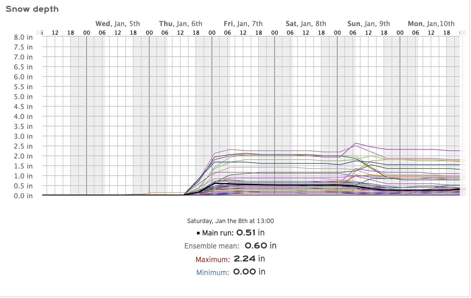
FWIW --> GEFS has no clue. Max is 16. Min is 0. Mean is 2. -
Western PA/Pittsburgh Winter 2021/22 Discussion
MikeB_01 replied to meatwad's topic in Upstate New York/Pennsylvania
I dont buy that rain/snow map. Low track still look really good for us. If it take that track through Harrisburg we should be real good -
Western PA/Pittsburgh Winter 2021/22 Discussion
MikeB_01 replied to meatwad's topic in Upstate New York/Pennsylvania
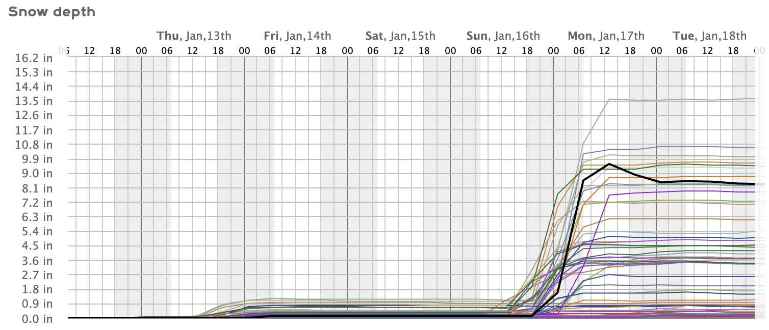
I should mention that the black line is the deterministic run of the Euro. The mean is about 4"
-
Western PA/Pittsburgh Winter 2021/22 Discussion
MikeB_01 replied to meatwad's topic in Upstate New York/Pennsylvania
12z EPS
-
Western PA/Pittsburgh Winter 2021/22 Discussion
MikeB_01 replied to meatwad's topic in Upstate New York/Pennsylvania
If we have a run in which that beautiful magenta color makes it over AGC, I am going to need someone to inject that straight into my veins. Glorious -
Western PA/Pittsburgh Winter 2021/22 Discussion
MikeB_01 replied to meatwad's topic in Upstate New York/Pennsylvania
Everyone buckle up... Right now we are in the drivers seat. We know that models waffle and this one definitely will. Prepare for some shifts in either way and hope that it comes back. -
Western PA/Pittsburgh Winter 2021/22 Discussion
MikeB_01 replied to meatwad's topic in Upstate New York/Pennsylvania
. -
Western PA/Pittsburgh Winter 2021/22 Discussion
MikeB_01 replied to meatwad's topic in Upstate New York/Pennsylvania
As I was saying.. GEFS looking pretty good right now. The variability is crazy, but expected for this far out. I think any of us would take a 6+" storm right now.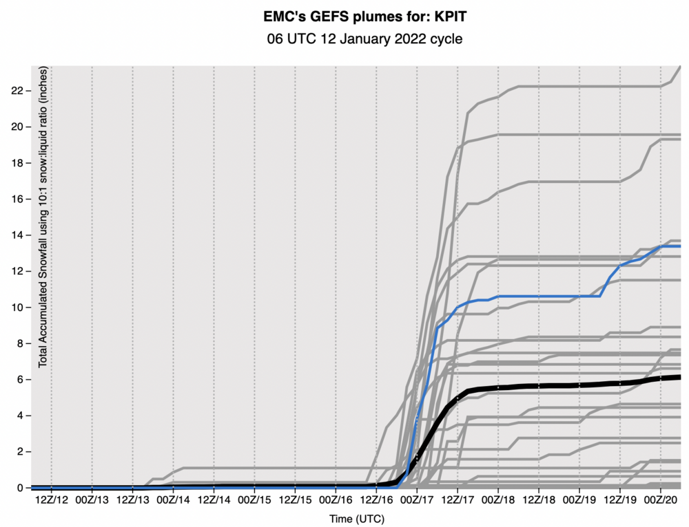
-
Western PA/Pittsburgh Winter 2021/22 Discussion
MikeB_01 replied to meatwad's topic in Upstate New York/Pennsylvania
I noticed this as well. That warm air is getting closer and closer to being sucked up right over western PA. A return of that dreaded warm tongue of death. The good news is that the GEFS is in a good spot. Moving west with each run, but for now it is good. I think... -
Western PA/Pittsburgh Winter 2021/22 Discussion
MikeB_01 replied to meatwad's topic in Upstate New York/Pennsylvania
The storm is there… time to watch. Hopefully the GfS has a better idea . -
Western PA/Pittsburgh Winter 2021/22 Discussion
MikeB_01 replied to meatwad's topic in Upstate New York/Pennsylvania
I know we all love the big storms, but sometimes on really clear sky mornings like today, it just makes me smile. Have a great day everyone. -
Western PA/Pittsburgh Winter 2021/22 Discussion
MikeB_01 replied to meatwad's topic in Upstate New York/Pennsylvania
Almost 2.5 down here in the south hills. Still some mood snow flying out there. Nice to see. -
Western PA/Pittsburgh Winter 2021/22 Discussion
MikeB_01 replied to meatwad's topic in Upstate New York/Pennsylvania
Yea, not bad so far. Snow line is out of Youngstown and moving east. Probably 2 more hours of this light stuff. The nice part is that because it is so cold, no compaction. Just dry and fluffy out there. -
Western PA/Pittsburgh Winter 2021/22 Discussion
MikeB_01 replied to meatwad's topic in Upstate New York/Pennsylvania
Not sure they NWS is buying into the rapids. With their afternoon (1pm) discussion, they mention areas outside of the current advisories seeing less impacts. I would have thought that if they were going to change the advisories it would have been with the afternoon update. -
Western PA/Pittsburgh Winter 2021/22 Discussion
MikeB_01 replied to meatwad's topic in Upstate New York/Pennsylvania
I remember this one very vividly. I was in Youngstown for a wedding that day. THUMPING doesn't do it justice. The drive home was incredible. A foot of snow to grass in less than 60 miles. Wild. -
Western PA/Pittsburgh Winter 2021/22 Discussion
MikeB_01 replied to meatwad's topic in Upstate New York/Pennsylvania
Alright, hear me out. I feel like this storm has a decent chance of over performing. Since last night, the models have moved a little further to the NW with the precip shield. This is also inline with the rapid models that are starting to see this event. The reason I'm so optimistic is the temperature and time of day. The sun will be down and the temps will be falling from the mid 20's to the upper teens. We will see 15:1 or better ratios for the majority of the event and every flake that falls is going to stick. Call me an optimist, but after looking tonight, I wont be surprised if most of AGC wakes up to 3+ and Westmoreland seeing 5+. Here's hoping -
Western PA/Pittsburgh Winter 2021/22 Discussion
MikeB_01 replied to meatwad's topic in Upstate New York/Pennsylvania
. -
Western PA/Pittsburgh Winter 2021/22 Discussion
MikeB_01 replied to meatwad's topic in Upstate New York/Pennsylvania
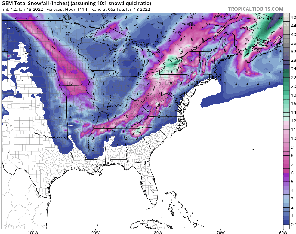
12z run of the Euro Ensembles.
-
Western PA/Pittsburgh Winter 2021/22 Discussion
MikeB_01 replied to meatwad's topic in Upstate New York/Pennsylvania
12z suite got me like...