MikeB_01
-
Posts
1,827 -
Joined
-
Last visited
Content Type
Profiles
Blogs
Forums
American Weather
Media Demo
Store
Gallery
Everything posted by MikeB_01
-

Western PA/Pittsburgh Winter 2021/22 Discussion
MikeB_01 replied to meatwad's topic in Upstate New York/Pennsylvania
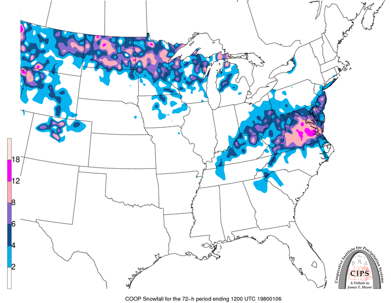
here are the top 3 analogs on CIPS. This is based on the 12z NAM at hour 36
-
Western PA/Pittsburgh Winter 2021/22 Discussion
MikeB_01 replied to meatwad's topic in Upstate New York/Pennsylvania
I know purple is 6 and pink is 12. But distinguishing them on those maps is a different language . -
Western PA/Pittsburgh Winter 2021/22 Discussion
MikeB_01 replied to meatwad's topic in Upstate New York/Pennsylvania
15z run of SREFs up to 8. -
Western PA/Pittsburgh Winter 2021/22 Discussion
MikeB_01 replied to meatwad's topic in Upstate New York/Pennsylvania
Agreed. We could start summer on January 19th and i would be very pleased -
Western PA/Pittsburgh Winter 2021/22 Discussion
MikeB_01 replied to meatwad's topic in Upstate New York/Pennsylvania
19/20 of those are solid. . -
Western PA/Pittsburgh Winter 2021/22 Discussion
MikeB_01 replied to meatwad's topic in Upstate New York/Pennsylvania
It is inevitable for the evolution of the storm. Where it goes and how long it stays around will change totals. Lots of models have the dry slot to the south and east of AGC. . -
Western PA/Pittsburgh Winter 2021/22 Discussion
MikeB_01 replied to meatwad's topic in Upstate New York/Pennsylvania
Hilarious considering the NAM just put out 30+ on Erie. He has 3-6 -
Western PA/Pittsburgh Winter 2021/22 Discussion
MikeB_01 replied to meatwad's topic in Upstate New York/Pennsylvania
This pleases me. . -
Western PA/Pittsburgh Winter 2021/22 Discussion
MikeB_01 replied to meatwad's topic in Upstate New York/Pennsylvania
I feel like a lot of the guidance is on board though. Everything except the NAM is east. NAM the only one that is stubbornly holding out on a westward solution. As i said earlier, Im not sure how much stock mets are putting in NAM. Here is the warning map for CLE NWS. Last 4-5 runs of the NAM have dropped more than a foot on CLE and points east. Not even a WWA for Cuyahoga County (where cleveland is).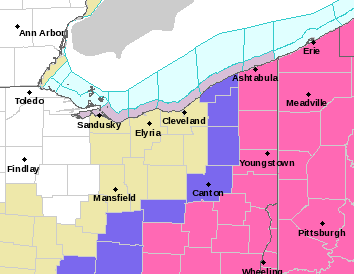
-
Western PA/Pittsburgh Winter 2021/22 Discussion
MikeB_01 replied to meatwad's topic in Upstate New York/Pennsylvania
Even when in range, i HRRR is a superior model to the NAM -
Western PA/Pittsburgh Winter 2021/22 Discussion
MikeB_01 replied to meatwad's topic in Upstate New York/Pennsylvania
Definitely a different set up than 2019. The ULL went right over Pittsburgh. And about 48 - 36 hr out, we started to see the westward move. The WTD showed itself early on. -
Western PA/Pittsburgh Winter 2021/22 Discussion
MikeB_01 replied to meatwad's topic in Upstate New York/Pennsylvania
Cautiously optimistic. That is how i would describe my mood right now. Nowcasting strategy -> Take a Xanax, grab some snow brews, and enjoy the uncertainty -
Western PA/Pittsburgh Winter 2021/22 Discussion
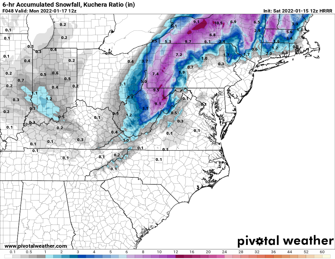
MikeB_01 replied to meatwad's topic in Upstate New York/Pennsylvania
This is a fun one... This is the 6hr snowfall while we are under the deform band. 1"+/hr rates showing up on HRRR
-
Western PA/Pittsburgh Winter 2021/22 Discussion
MikeB_01 replied to meatwad's topic in Upstate New York/Pennsylvania
Yeah, still some time to wobble. Could easily see some changes over the next 24. The good news is that the hi res models are coming in as they are. Heavy and consistent. -
Western PA/Pittsburgh Winter 2021/22 Discussion
MikeB_01 replied to meatwad's topic in Upstate New York/Pennsylvania
Dry slot in westmoreland county on that 18z HRRR, but it does't seem to change the accumulations a whole lot. Once the atmosphere saturates, that deformation band is crushing us.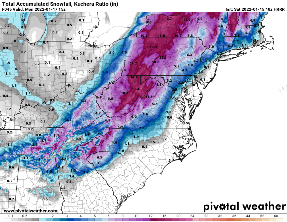
-
Western PA/Pittsburgh Winter 2021/22 Discussion
MikeB_01 replied to meatwad's topic in Upstate New York/Pennsylvania
This is what I was talking about earlier. Experience and intuition. However, ice would be a reflection of freezing rain, which we won’t see. Air too cold at 925 . -
Western PA/Pittsburgh Winter 2021/22 Discussion
MikeB_01 replied to meatwad's topic in Upstate New York/Pennsylvania
Temp profile looks good here. . -
Western PA/Pittsburgh Winter 2021/22 Discussion
MikeB_01 replied to meatwad's topic in Upstate New York/Pennsylvania
Look at that 31.5 bullseye in Erie . -
Western PA/Pittsburgh Winter 2021/22 Discussion
MikeB_01 replied to meatwad's topic in Upstate New York/Pennsylvania
It’s pretty expansive. Though it totally depends on the warm layer aloft. We know the surface-925 will be plenty cold. Even if the 850 level is 33 for a little, I think it is very brief. We have a deepening ULL with heavy rates and it will cause that column to cool quickly. . -
Western PA/Pittsburgh Winter 2021/22 Discussion
MikeB_01 replied to meatwad's topic in Upstate New York/Pennsylvania
Woah. . -
Western PA/Pittsburgh Winter 2021/22 Discussion
MikeB_01 replied to meatwad's topic in Upstate New York/Pennsylvania
GFS? . -
Western PA/Pittsburgh Winter 2021/22 Discussion
MikeB_01 replied to meatwad's topic in Upstate New York/Pennsylvania
I just think this is where met intuition / experience comes in ahead of modeling. The discussions are full of comments about the rate of evaporative cooling. Even if we sleet, it should be brief and then we should be thumping again. -
Western PA/Pittsburgh Winter 2021/22 Discussion
MikeB_01 replied to meatwad's topic in Upstate New York/Pennsylvania
Honestly, i didn't think the RGEM was bad. I saw the sleet show up, but the column cooled fast enough that Im not worried. Awesome rates on that run. -
Western PA/Pittsburgh Winter 2021/22 Discussion
MikeB_01 replied to meatwad's topic in Upstate New York/Pennsylvania
Me neither. Especially that wide spread. Now that is definitely the high end. That is the max. But I’ll take a chance. . -
Western PA/Pittsburgh Winter 2021/22 Discussion
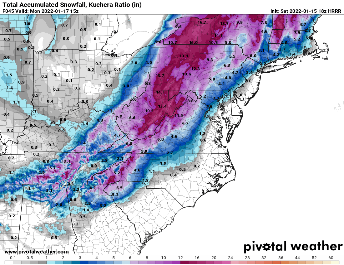
MikeB_01 replied to meatwad's topic in Upstate New York/Pennsylvania
Beautiful deform band on that run.