

mikem81
-
Posts
1,113 -
Joined
-
Last visited
Content Type
Profiles
Blogs
Forums
American Weather
Media Demo
Store
Gallery
Everything posted by mikem81
-
2-7-21 Sunday 8-12 hour nor'easter snowstorm roughly 5A-5P
mikem81 replied to wdrag's topic in New York City Metro
Its basically a 990 on the BM -
2-7-21 Sunday 8-12 hour nor'easter snowstorm roughly 5A-5P
mikem81 replied to wdrag's topic in New York City Metro
NAM definitely a bit NW with the LP placement -
2-7-21 Sunday 8-12 hour nor'easter snowstorm roughly 5A-5P
mikem81 replied to wdrag's topic in New York City Metro
-
2-7-21 Sunday 8-12 hour nor'easter snowstorm roughly 5A-5P
mikem81 replied to wdrag's topic in New York City Metro
-
2-7-21 Sunday 8-12 hour nor'easter snowstorm roughly 5A-5P
mikem81 replied to wdrag's topic in New York City Metro
THE LP is east of 12Z -
2-7-21 Sunday 8-12 hour nor'easter snowstorm roughly 5A-5P
mikem81 replied to wdrag's topic in New York City Metro
EURO ticked slightly NW from 0Z. Good sign. Not too amped. -
2-7-21 Sunday 8-12 hour nor'easter snowstorm roughly 5A-5P
mikem81 replied to wdrag's topic in New York City Metro
When are they not amped? -
2-7-21 Sunday 8-12 hour nor'easter snowstorm roughly 5A-5P
mikem81 replied to wdrag's topic in New York City Metro
When are they not amped? -
2-7-21 Sunday 8-12 hour nor'easter snowstorm roughly 5A-5P
mikem81 replied to wdrag's topic in New York City Metro
Its comparing 12Z to 18Z and its basically the entire storm....Here is next frame of 18Z -
2-7-21 Sunday 8-12 hour nor'easter snowstorm roughly 5A-5P
mikem81 replied to wdrag's topic in New York City Metro
Agreed. And its where I would want the GFS to be ight about now -
2-7-21 Sunday 8-12 hour nor'easter snowstorm roughly 5A-5P
mikem81 replied to wdrag's topic in New York City Metro
compared to -
2-7-21 Sunday 8-12 hour nor'easter snowstorm roughly 5A-5P
mikem81 replied to wdrag's topic in New York City Metro
Was a small shift in the right direction. -
2-7-21 Sunday 8-12 hour nor'easter snowstorm roughly 5A-5P
mikem81 replied to wdrag's topic in New York City Metro
GFS looks like it will go west as well -
2-7-21 Sunday 8-12 hour nor'easter snowstorm roughly 5A-5P
mikem81 replied to wdrag's topic in New York City Metro
RGEM is well west of 12Z but still SE for most... -
2-7-21 Sunday 8-12 hour nor'easter snowstorm roughly 5A-5P
mikem81 replied to wdrag's topic in New York City Metro
ICON same track as NAM (slightly less precip). All snow for the metro. -
2-7-21 Sunday 8-12 hour nor'easter snowstorm roughly 5A-5P
mikem81 replied to wdrag's topic in New York City Metro
Lots of hits on these as well. (half of GEPS and most GEFS) -
2-7-21 Sunday 8-12 hour nor'easter snowstorm roughly 5A-5P
mikem81 replied to wdrag's topic in New York City Metro
-
2-7-21 Sunday 8-12 hour nor'easter snowstorm roughly 5A-5P
mikem81 replied to wdrag's topic in New York City Metro
EURO will be NW of 0Z -
2-7-21 Sunday 8-12 hour nor'easter snowstorm roughly 5A-5P
mikem81 replied to wdrag's topic in New York City Metro
When the NAVGEM shows this... usually a good sign -
2-7-21 Sunday 8-12 hour nor'easter snowstorm roughly 5A-5P
mikem81 replied to wdrag's topic in New York City Metro
Way NW of 0Z.. 250 miles or so... -
2-7-21 Sunday 8-12 hour nor'easter snowstorm roughly 5A-5P
mikem81 replied to wdrag's topic in New York City Metro
ICON came a little east. GFS/NAM/ICON look pretty similar now in terms of storm track (NAM being most robust) -
2-7-21 Sunday 8-12 hour nor'easter snowstorm roughly 5A-5P
mikem81 replied to wdrag's topic in New York City Metro
SOme foreign models have been showing this. Icon and French model -
2-7-21 Sunday 8-12 hour nor'easter snowstorm roughly 5A-5P
mikem81 replied to wdrag's topic in New York City Metro
The northern stream energy for this potential is somewhere off the coast of NW canada right now....calm down -
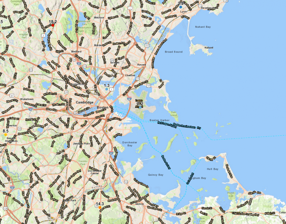
Just to further point out the ridiculous cutoff in BOS area. On Google Earth I measured 7.5 miles between Logan and Winchester, MA (1.2 inches to 18.2 inches). 16 inch difference going 7.5 miles NW of Logan. Thats basically the difference between JFK and LGA....Dont think there has ever been such a cutoff in our area.
- 1,932 replies
-
- 2
-

-
- heavy snow
- wind damage
- (and 1 more)
-
Has been snowing lightly here since around noon with some breaks. Prob got another inch this afternoon with all the light snow for a storm total of 15-16 inches. Really cant complain about that even with those crazy totals to the NW of the metro..
- 1,932 replies
-
- 1
-
-
- heavy snow
- wind damage
- (and 1 more)
