

TullyHeel
-
Posts
12,875 -
Joined
-
Last visited
Content Type
Profiles
Blogs
Forums
American Weather
Media Demo
Store
Gallery
Everything posted by TullyHeel
-
Louisiana is getting hit with tornadoes now. I guess it's not considered in the SE here, but I've been watching coverage from a station in New Orleans. They have a confirmed tornado with debris showing on radar. https://www.wwltv.com/live-video
-
RAH has a chance of showers and storms here starting tonight and going through next Wednesday.
-
Well, we had another severe thunderstorm watch last night, but nothing severe around me. Had heavy rain and some thunder. The biggest severe weather around here this year remains the tornadoes we had in May when we were not under any kind of watch.
-
I am talking specifically for Wake and what I have experienced. We have more severe storms when we are not under a watch than when we are the past few years for some reason. I am talking about comparing the severity of the storms, like when we had tornadoes earlier this month without any watch.
-
Still less severe compared to other storms we have had here the past few years when not under a watch.
-
And once again the storms are less severe here when we're under a watch versus when we aren't.
-
And so far everything is moving around Wake. Typical whenever we're under a watch.
-
Some warnings out now. https://forecast.weather.gov/wwamap/wwatxtget.php?cwa=rah&wwa=severe thunderstorm warning
-
Looks like a severe thunderstorm watch will be coming soon. Guess we'll have to see if we actually get anything severe with a watch this time, or if the streak of having more severe weather around here without a watch continues. Mesoscale Discussion 0909 NWS Storm Prediction Center Norman OK 1107 AM CDT Fri May 31 2019 Areas affected...western portions of VA/NC and the VA/NC Piedmont Concerning...Severe potential...Severe Thunderstorm Watch likely Valid 311607Z - 311800Z Probability of Watch Issuance...80 percent SUMMARY...Isolated to widely scattered thunderstorm development is forecast over the next 1-2 hours (12pm-2pm EDT) near the higher terrain over western NC and western/southwestern VA. Isolated storms may also develop over the Piedmont by 2pm EDT. DISCUSSION...Late morning water vapor imagery loop shows a mid-level shortwave trough over KY/TN and this feature is forecast to reach the southern Appalachians by mid afternoon. Visible satellite imagery shows a swelling cumulus field over the southern Appalachians immediately east of the eastward-migrating disturbance. Surface observations indicate temperatures have warmed to near 80 degrees F near the mountains and into the middle 80s over the NC Piedmont. Low-level moisture increases from west to east across NC with surface dewpoints near 60 degrees F in the west, low-middle 60s over the Piedmont, and upper 60s to near 70 in the coastal plain. Reflective of the low-level moisture field, buoyancy is forecast to be highest near and east of I-95 with 2000-2500 J/kg MLCAPE expected by late afternoon with steep 0-3km lapse rates. Strong heating will contribute to 1500-2000 J/kg MLCAPE farther west near the I-77 corridor by early afternoon. A belt of 30-35kt westerly 500mb flow will act to organize updrafts this afternoon beneath 60-80kt upper-level westerly flow. Despite weak low-level flow, elongated hodographs will favor the potential for splitting supercells and severe multicells capable of large hail and severe gusts (60mph). The propensity for wind damage will likely increase coincident with richer low-level moisture as storms move/grow upscale from west-central into east-central portions of NC later this afternoon into the early evening.
-

Pittsburgh PA Area Spring and Summer 2019
TullyHeel replied to CranberryWX's topic in Upstate New York/Pennsylvania
Pretty good rotation showing up near Pikes Peak, PA. -
Pittsburgh PA Area Spring and Summer 2019
TullyHeel replied to CranberryWX's topic in Upstate New York/Pennsylvania
WTAE reporting circulation going right over Indiana, PA. -
Well, guess we are in the boring part of the year with regards to weather here. Looking forward to going to the beach, lake, and amusement parks this summer. But have to hang out at the midwest forum to get my severe weather fix.
-
Summer officially started Monday. That's when I saw the first lightning bug of the year.
-
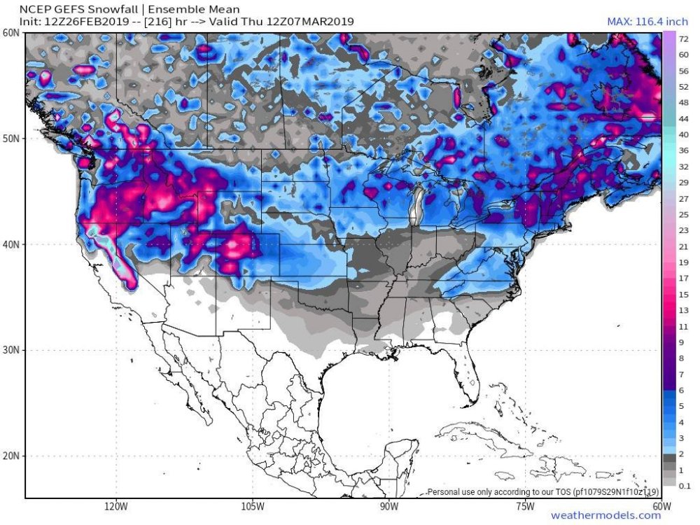
This one is a little different. Before it was usually the FV3 showing a storm past 7 days. This time both the Euro and GFS both were showing a storm and a big hit for NC yesterday. Those two haven't been on the same page since the December storm. But I guess it really doesn't matter, because unless it's inside 5 days now it's just fantasy.
-
EPS is really down here, too. Only 2 or 3 panels showing any snow.
-
Euro has rain here with the first wave, and out to sea with the second wave. Crazy how different things are just 24 hours later. It's really maddening.
-
The GEFS mean still gives me hope.
-
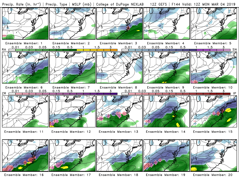
Still a wide spread with the GEFS. Looks like for me 8 have no precip at all, 6 have rain, and 6 have something frozen.
-
Shocker.
-
Yeah, I know with the December storm it really wasn't until 72 hours out that it looked good again for parts of NC.
-
The sad thing is that is the first time really since the December storm that we have seen the models actually agree on a storm and be consistent with the outcome for a whole day. I really thought we were onto something with the Euro jumping on board. I think with the December storm we were worried about the models going north with some runs, but then they came back a little further south to give us that big hit. I think I am recalling that north shift and then back south correctly. If so, maybe we can get that to happen again with this threat.
-
GFS goes from 6 to 8 inches for parts of NC yesterday to a dusting to maybe an inch today.
-
Funny how things can change in 24 hours. Yesterday, things looked great because the GFS showed a big hit for NC, and then the Euro came on board. yesterday was the first time they both showed a good storm for NC. Then things started going the other way with the runs last night. I guess there is time for it to come back around, but now it looks the models are showing less and less of a hit with the runs since last night.
-
-
This threat is really starting to evolve nicely. Great to see the Euro with a big hit for NC now. We are seeing strong signals for a storm on all the models now. And we have not had this much agreement and consistency for a threat this far out since the early December storm. This is legit.


