TullyHeel
-
Posts
12,875 -
Joined
-
Last visited
Content Type
Profiles
Blogs
Forums
American Weather
Media Demo
Store
Gallery
Everything posted by TullyHeel
-
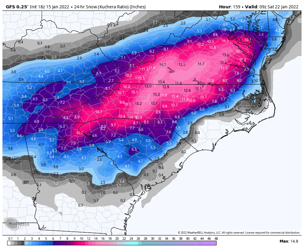
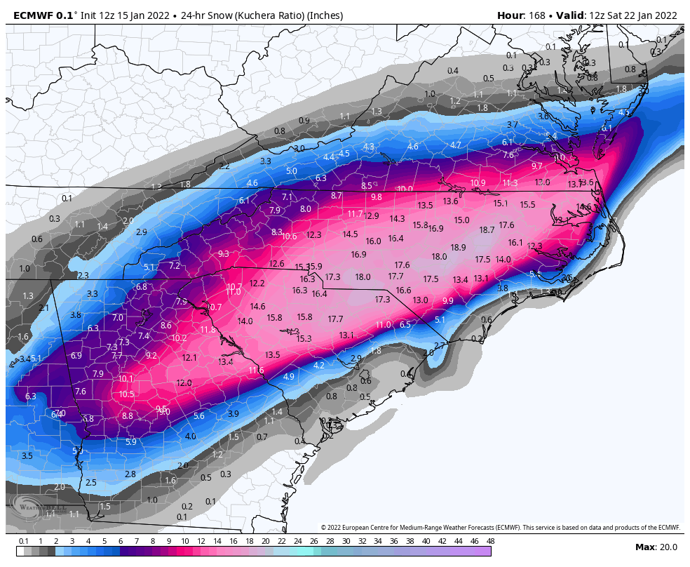
So the Euro, GFS, and CMC all had the storm for the same time and similar totals, and now they have it to the south. Seen this before and in the past it ended up trending NW.
-
What's the latest runs showing?
-

January 20-22 “bring the mojo” winter storm threat
TullyHeel replied to lilj4425's topic in Southeastern States
GFS with the storm and simliar totals as the Euro.
-
January 20-22 “bring the mojo” winter storm threat
TullyHeel replied to lilj4425's topic in Southeastern States
This needs to be in the banter and whining thread. -
The snow train is coming.
-
Wow, all three showing almost the exact same setup and totals.
-
Can we really get 3 models showing the same storm this far out?
-
Please take that negative energy to the sanatorium.
-
Why not?
-
Tomorrow is just setting the stage for the real good stuff.
-
January 20-22 “bring the mojo” winter storm threat
TullyHeel replied to lilj4425's topic in Southeastern States

-
-
January 20-22 “bring the mojo” winter storm threat
TullyHeel replied to lilj4425's topic in Southeastern States
Hope this one is for real. Looks like what the models were showing for tomorrow's storm a week out, and we know how that turned out. But I am going to stay positive. Let's get this! -
Anyone got a pic of the CMC? Hope next weekend is a legit shot at snow here and not this mix to rain crap. We usually get 3 shots at snow at the most for my area. I think anything 3 inches or more would be considered a good storm since we only average about 6 inches of snow here for winter.
-
With a 14 year old son, a 12 year old daughter, and a wife that are all redheads, three dogs, and a cat.
-
So, the January 2000 Carolina Crusher happened because the models showed the track of the system was too far off the coast, meaning no precip. This one the models say will be too far inland, causing the air to warm too much for snow.
-
AMEN!
-
This thread is your friend.
-
No, besides the mountains, most of NC is not getting pure snow. Most of NC will get sleet, freezing rain, and rain if the forecast is right. I usually do better than Raleigh with snow because I am further north.
-
I think it's simply because most of NC isn't getting pure snow, and half the posters are from here. They checked out and are looking for the next storm.
-
Yeah, hopefully it doesn't go to crap like tomorrow's storm. That one looked good just 6 days out, too.
-
Only a week away. Maybe this is the one for central NC.
-
I would love to see in the past 12 years how often areas in other states further south than the Triangle have gotten more snow than here.
-