TPAwx
-
Posts
583 -
Joined
-
Last visited
Content Type
Profiles
Blogs
Forums
American Weather
Media Demo
Store
Gallery
Everything posted by TPAwx
-
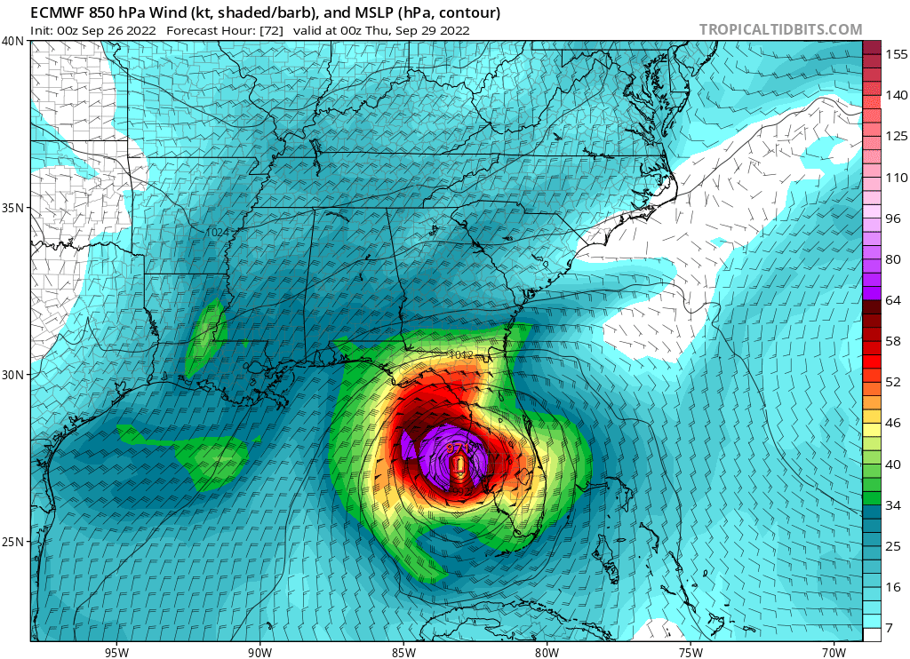
6z Euro has landfall right at Sarasota around 11pm Wednesday. That's a jump north from 0z
-
Yes indeed. You've got that sustained fetch for 24+ hours, layered with 20+ inches of rain that has nowhere to go. The main rivers are dumping all that into the bays. I'm on an east facing shoreline of Hillsborough Bay so I'm going to have an n=1 scenario play out.
-
Assuming track is south of TB headlines for this area will likely be extensive rain driven flooding and downed trees into structures. Some of the QPF outputs on the overnight model runs are ridiculous. Looks like 20+ is possible if the track and slowdown verifies.
-
Yeah for sure, plenty of wind and 15+ inches of rain on this run.
-
Edit, Euro landfall between Siesta Key and Venice verbatim Wed 5pm
-
Euro has landfall near Sarasota Siesta Key/Venice late Wednesday
-
it would be devastating. To preface, much of the area has minor but disruptive flooding with heavy summer t-storms. That much rain has no place to go. The city/metro has extremely dense vegetation and tree cover (one research outfit rated Tampa the #1 city in the world for tree cover). We obviously have tall palm trees but we have a lot of huge oaks. Massive amounts of trees and branches would come down on properties and streets, power outages would be extensive. All that falling and standing water would do a number on structures. With that stall easterly fetch would also push a ton of water around and carve up east facing shoreline. I'm not a hydrologist so I'm sure there's plenty of other impacts on infrastructure and public health. Overall, a sub-optimal amount of rain and scenario.
-
Hard pass.
-
-
The scenarios are not equally devastating. TB/Hillsborough/Pinelllas County have a much higher degree of population/property/economic exposure and risk than Sarasota or Fort Myers. It’s easily accessible data and research.
-
GFS coming in tight to coast earlier, would drive higher surge across TB
-
Perhaps the UK hooked onto the late stage evolution from early stages and this goes inland south of TB.
-
Local surge watch was initialized at 5-8 and then updated to 7-10. With the GFS and Euro scenarios it would be higher in some locations.
-
Reminds me of the NAM runs when I lived in NOVA that would spit out 50 inches of snow. Thankfully this one won’t verify either
-
It’s a crusher. Watching the loop, it literally crawls up to the bay and sits over us. Getting ready to eat a wrap and some onion rings from my freezer (use it or lose it), just lost my appetite.
-
GFS as depicted is really bad for TB
-
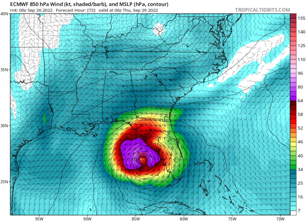
12z is coming in east of 6z edit - material shift thru 63
-
ICON is a terrible solution for TB
-
Mandatory evac Zone A for Tampa peeps starting 2pm today.
-
Not a lot of analogues, but for reference Eta was in the low 990s at 50 miles off Clearwater Beach and produced a 4 ft surge in Old Port Tampa Bay. At peak Eta was 922/130 kts
-
The full 6z Euro run has the crawl/stall WSW/W of Tampa Bay, and it’s pushing a ton of energy up the coast and in the bays. Not certain how this equates to total surge potential, but it remains an impactful solution and we still have margin of error with the track at this stage.
-
Yeah the winds should be less of an issue whilst we launch the kayaks from our roof.
-

-
6z Euro appears to shift west
-
Opening bid is 5-8 for surge. Had 4 here with a weakening TS Eta 50 miles offshore, so…. STORM SURGE WATCH NWS TAMPA BAY RUSKIN FL 512 AM EDT MON SEP 26 2022 FLZ151-261715- /O.EXA.KTBW.SS.A.1009.000000T0000Z-000000T0000Z/ 512 AM EDT MON SEP 26 2022 Coastal Hillsborough- ...HURRICANE WATCH IN EFFECT... ...STORM SURGE WATCH IN EFFECT... A Hurricane Watch means hurricane-force winds are possible somewhere within this area within the next 48 hours A Storm Surge Watch means life-threatening inundation, from rising water moving inland from the coastline, is possible somewhere within this area within the next 48 hours * LOCATIONS AFFECTED - Tampa - Apollo Beach - Westchase * WIND - LATEST LOCAL FORECAST: Equivalent Tropical Storm force wind - Peak Wind Forecast: 45-55 mph with gusts to 75 mph - Window for Tropical Storm force winds: Wednesday morning until Friday morning - THREAT TO LIFE AND PROPERTY THAT INCLUDES TYPICAL FORECAST UNCERTAINTY IN TRACK, SIZE AND INTENSITY: Potential for wind greater than 110 mph - The wind threat has remained nearly steady from the previous assessment. - PLAN: Plan for extreme wind of equivalent CAT 3 hurricane force or higher. - PREPARE: Efforts to protect life and property should now be underway. Prepare for catastrophic wind damage. - ACT: Act now to complete preparations before the wind becomes hazardous. - POTENTIAL IMPACTS: Devastating to Catastrophic - Structural damage to sturdy buildings, some with complete roof and wall failures. Complete destruction of mobile homes. Damage greatly accentuated by large airborne projectiles. Locations may be uninhabitable for weeks or months. - Numerous large trees snapped or uprooted along with fences and roadway signs blown over. - Many roads impassable from large debris, and more within urban or heavily wooded places. Many bridges, causeways, and access routes impassable. - Widespread power and communications outages. * STORM SURGE - LATEST LOCAL FORECAST: Life-threatening storm surge possible - Peak Storm Surge Inundation: The potential for 5-8 feet above ground somewhere within surge prone areas - Window of concern: early Wednesday morning until Thursday afternoon - THREAT TO LIFE AND PROPERTY THAT INCLUDES TYPICAL FORECAST UNCERTAINTY IN TRACK, SIZE AND INTENSITY: Potential for storm surge flooding greater than 6 feet above ground - The storm surge threat has increased from the previous assessment. - PLAN: Plan for life-threatening storm surge flooding of greater than 6 feet above ground. - PREPARE: Evacuation preparations should be underway. Assemble disaster supplies and know your evacuation route. - ACT: Leave if evacuation orders are given for your area. Failure to heed evacuation orders may result in the loss of your life. - POTENTIAL IMPACTS: Extensive - Large areas of deep inundation with storm surge flooding accentuated by battering waves. Structural damage to buildings, with several washing away. Damage compounded by floating debris. Locations may be uninhabitable for an extended period. - Large sections of near-shore escape routes and secondary roads washed out or severely flooded. Flood control systems and barriers may become stressed. - Severe beach erosion with significant dune loss. - Major damage to marinas, docks, boardwalks, and piers. Many small craft broken away from moorings, especially in unprotected anchorages with some lifted onshore and stranded.