TPAwx
-
Posts
583 -
Joined
-
Last visited
Content Type
Profiles
Blogs
Forums
American Weather
Media Demo
Store
Gallery
Everything posted by TPAwx
-
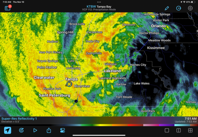
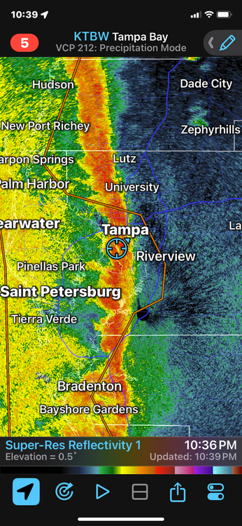
Starting up here in South Tampa. Impressive rainfall rates in this band.
-
BULLETIN Tropical Storm Debby Intermediate Advisory Number 8A NWS National Hurricane Center Miami FL AL042024 800 AM EDT Sun Aug 04 2024 ...DEBBY EXPECTED TO STRENGTHEN RAPIDLY BEFORE LANDFALL IN THE FLORIDA BIG BEND REGION... SUMMARY OF 800 AM EDT...1200 UTC...INFORMATION ---------------------------------------------- LOCATION...26.3N 84.2W ABOUT 155 MI...255 KM SW OF TAMPA FLORIDA ABOUT 205 MI...330 KM SSW OF CEDAR KEY FLORIDA MAXIMUM SUSTAINED WINDS...60 MPH...95 KM/H PRESENT MOVEMENT...NNW OR 330 DEGREES AT 13 MPH...20 KM/H MINIMUM CENTRAL PRESSURE...1001 MB...29.56 INCHES
-
Yah it had a different feel. Very heavy downpour and stiff breeze.
-
Too much track and intensity uncertainty to give advice with confidence. Wouldn't want to be there, especially with family or little ones, if the track holds and the systems taps into toasty water temps more than modeled. Some degree of surge or flooding is likely even with a low-end TS on that heading.
-
Could be a sneaky surprise for those of us near the bays in Hillsborough and Pinellas. A strengthening TS on that trajectory can bring a lot of flooding and impact to the usual areas. My guess is the center curves inland under the bay and we miss the worst.
-
Charge up brother.
-
Super intense line passed thru. Summer-like downpour.
-
Jan Medium/Long Range Disco 2: Total Obliteration is Coming
TPAwx replied to Jebman's topic in Mid Atlantic
Appears y’all have moved on to crabbing season. Last measurable snow here 47 years ago next Friday. Glass half full and such. -
-
Got a JD, passed the bar, and became partner since this system emerged off Africa.
-
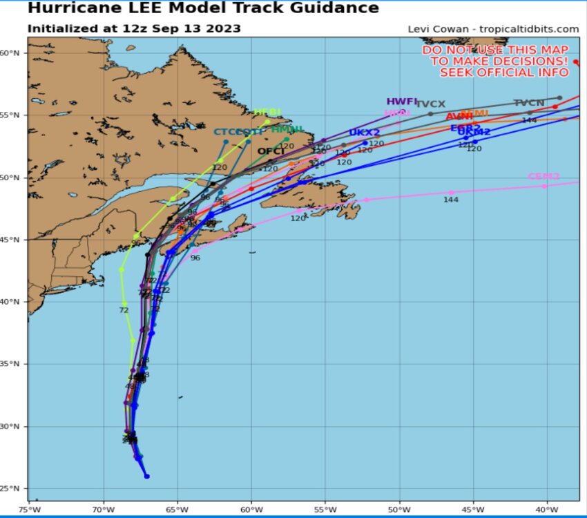
~175 mile average track error at 120h
-
Fantastic synoptic set-up to keep this monster away from a direct US impact. Love it!!
-
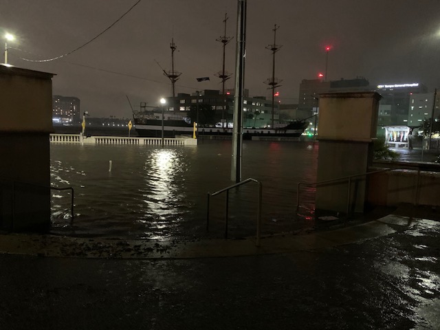
Lots of beautiful spots up the Nature Coast in serious trouble today.
-
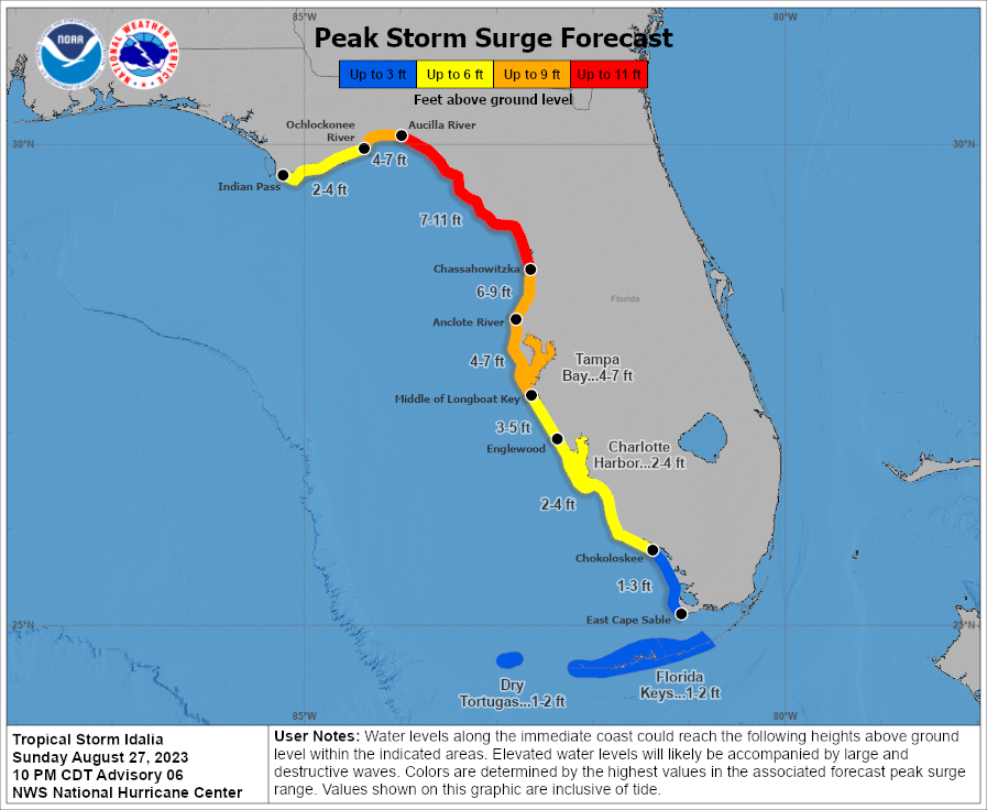
So the 4-7 for TB includes +1-2 from king tide
-
GFS has landfall near Dog Island Wednesday morning
-
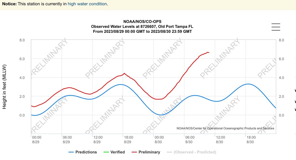
TS Eta gave us 4ft, the steps go down to a sidewalk and four traffic lanes and another sidewalk before the white barrier. Idalia will be on top of an enhanced full moon high tide at a likely Cat 3 intensity. The 4-7 surge forecast could end up a bit higher.
-
Had 4ft IMFY from TS Eta, on a not dissimilar track maybe a degree to the right of Idi’s current track. Of course Eta had a lot of energy built up. The 4-7 forecast for TB may end up on the lower range of possibilities.
-
Yes Ian evacs were issued for most TB coastal counties on 9/26. Really surprised Pinellas County hasn’t pulled the trigger yet, lots of folks at high risk even with current track. MacDill AFB just went mandatory so would expect Hills and Pinellas to follow soon for Zone A.
-
Euro remains to be seen, even with some westward movement on other guidance no reason for local TB region media mets and municipal officials to let up on messaging and urgency, esp for Zone A and B residents,
-
As 12z suite comes in, thinking about the ~50 n mi average track error at 48h
-
Up from last advisory
-
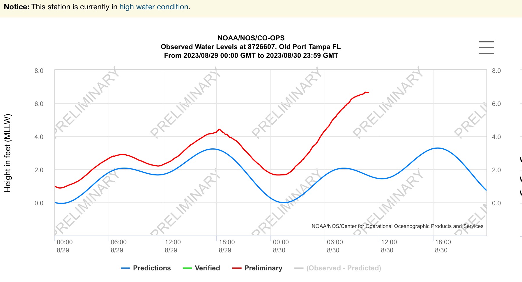
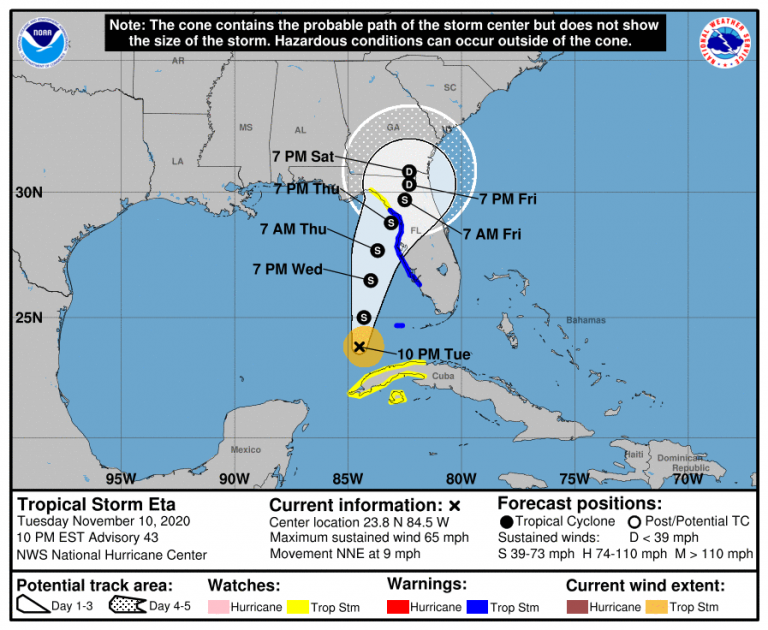
TS Eta's endgame track across Cedar Key in Nov 2020 gave us 4 ft along Bayshore.
-
Ready to roll out of Zone A but yeah this is going to surprise a lot of folks. We’ll see if the Tampa Bay No Majors in 102 years streak holds.
-
Interesting set up for TB region. Most likely a miss but if steering supports East and it picks up more heat could be problematic.
-
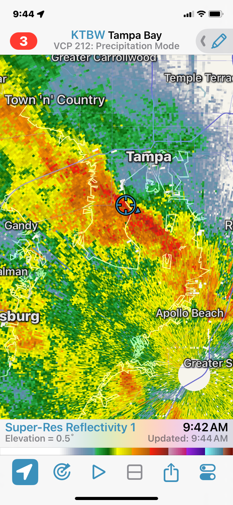
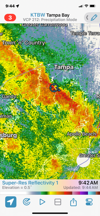
Hefty band passing thru. Max gust so far 53 mph