TPAwx
-
Posts
583 -
Joined
-
Last visited
Content Type
Profiles
Blogs
Forums
American Weather
Media Demo
Store
Gallery
Everything posted by TPAwx
-
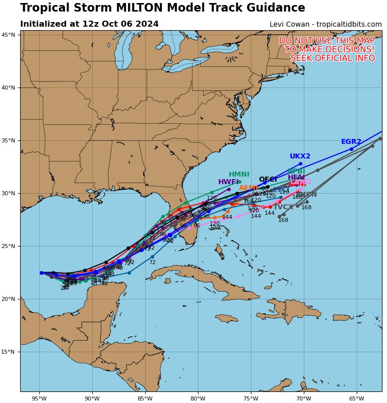
Milton is under 22N with a ESE trajectory. The northern most point on the Yucatan appears to be around 21.6N give or take a fraction.
-
Reasonable forecast based on expected intensity, will be sensitive to changes in track
-
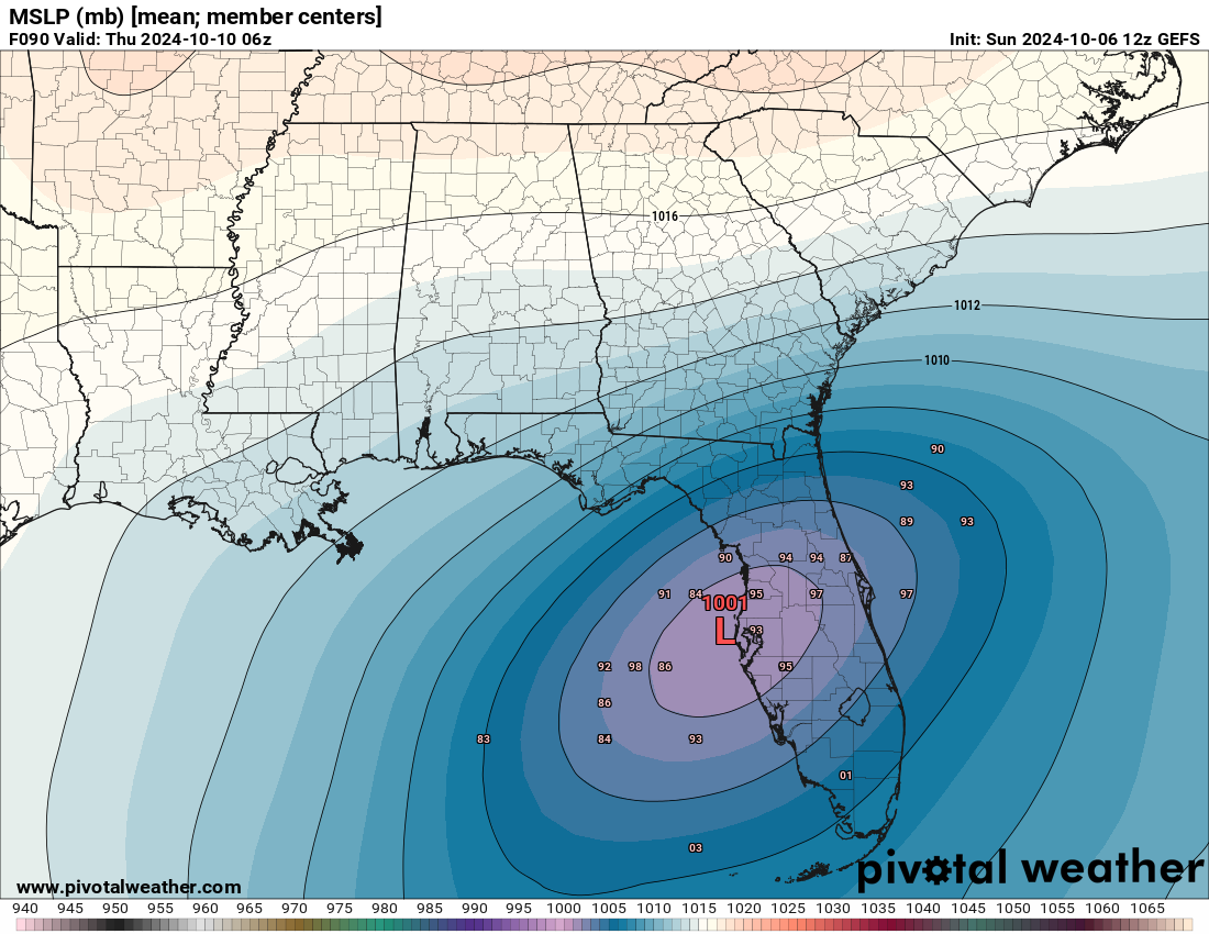
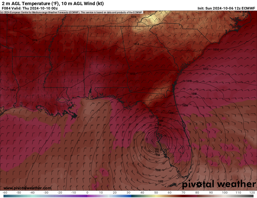
This run landfalls near Clearwater high 950s, Thursday morning. Extreme surge scenario for TB. HAFS-A similar landfall. HMON near Crystal River.
-
GFS appears to be heading for a landfall north of TB. Big time surge for the Bay area..
-
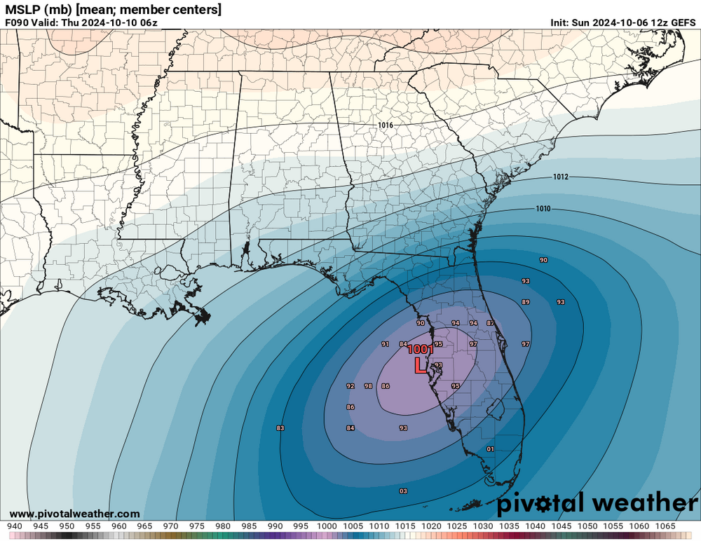
Mean track on the EPS very similar to the Op, perhaps slightly north, centered over TB Thursday morning.
-
As depicted landfall is right on the southern edge of the Bay, near Anna Maria Island, certainly not definitive at this point and resolution is not completely clear on the panel. Terrible solution for Sarasota south but likely less extreme for TB, water is pushed out. As usual every 10-20 miles could make a world of difference for peak surge impacts.
-
-
GFS heading for landfall north of TB, around Crystal River Wednesday evening. 958.
-
GFS op run coming in slightly south and deeper thru 48h.
-
-
7:00 AM CDT Sun Oct 6 Location: 22.6°N 94.9°W Moving: E at 5 mph Min pressure: 991 mb Max sustained: 60 mph
-
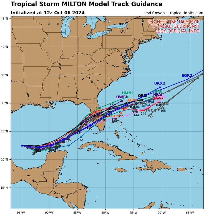
So near consensus on the majors (N/S of TB) How do the hurricane models score wrt track?
-
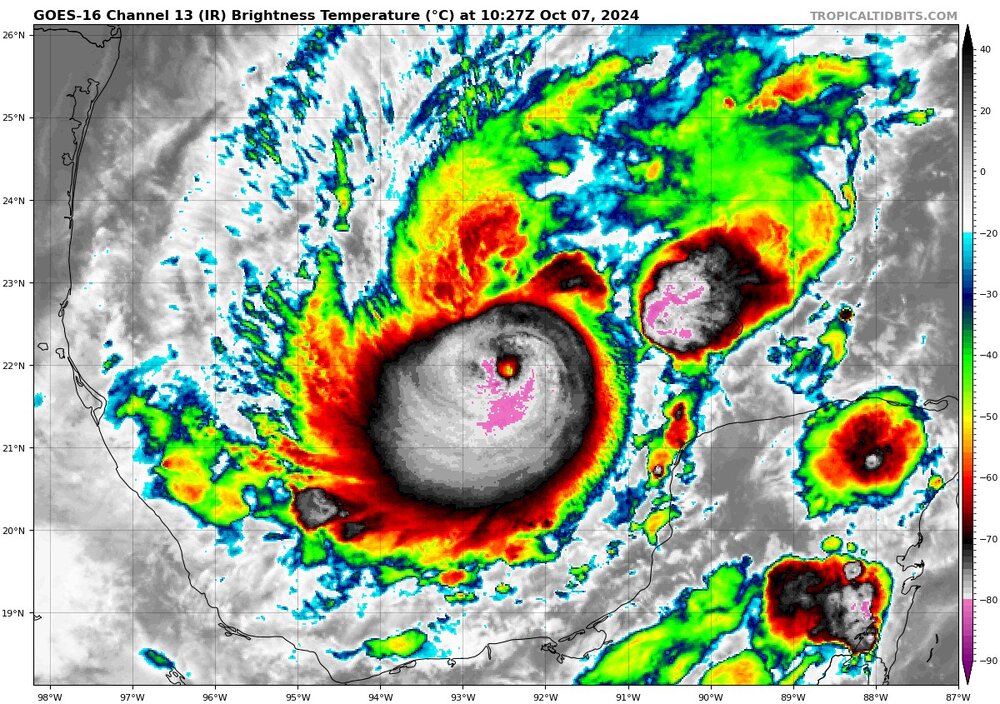
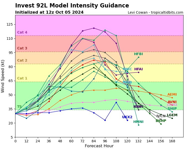
The A version bottomed at 910, HMON prob a few mb close. Seems like a signal. to GTFO of dodge.
-
Obligatory sub 900 HFAS-B run. 887 lol
-
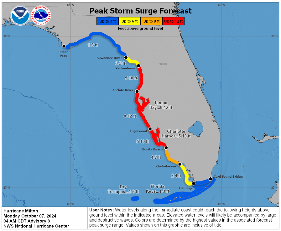
Local WFLA met very direct tonight. Clear layout of the threats and 10-15 foot surge potential.
-
The 18z HAFS A/B runs landfall near Crystal River, would do a number on Homosassa and surrounding areas, that have been hit hard multiple times the last few seasons. Great fishing and recreation in that area. Also would bring high end surge to TB. HMON heading west of Cedar Key it appears.
-
Then don’t look at the HAFS-B. Gassed up the cars in South Tampa. Target and Publix lots were pretty light, assume panic sets in tomorrow unless a significant south shift.
-
GFS landfall appears to be between Cedar Key and Crystal River 960s Not as extreme for TB but still a high end surge event.
-
GFS looks a touch slower or maybe just a bit south thru 60h vs 12z
-
Wow certainly not. Hyperbole is overused these days but this setup continues to progress towards worst case for TB/Pinellas and Hillsborough Counties most specifically.
-
The pre could certainly complicate evacuation scenarios.
-
GFS is a devastating setup for TB. Shifts in track and intensity obviously crucial for whatever areas are S and E of landfall.
-
Knocked out the initial Publix run for water. As we are in Zone A/closest to water always proactive with planning, but most of our go-to inland hotel options are sold out already, probably due to folks displaced by Helene. Managed to book one night in different cities Tues and Wed.
-
-
Local mets doing a good job after the 6z runs in highlighting the potential. The supply situation is dicey in many parts of the areas. Water, toilet paper, cleaning supplies , etc all in short stock.