TPAwx
-
Posts
583 -
Joined
-
Last visited
Content Type
Profiles
Blogs
Forums
American Weather
Media Demo
Store
Gallery
Everything posted by TPAwx
-
12z GFS landfall Holmes Beach early Thursday AM. High 950s.
-
6z HAFs-B landfall near Indian Rocks Beach. IMBY it’s massive surge from ground level and big oaks on the roof from the NE eyewall.
-
6z GFS over TB and MBY early AM Thursday. Appears to approach from southern end/Anna Maria Island.
-
6z ICON landfall between panels, appears to be around Anna Maria Island Thursday AM
-
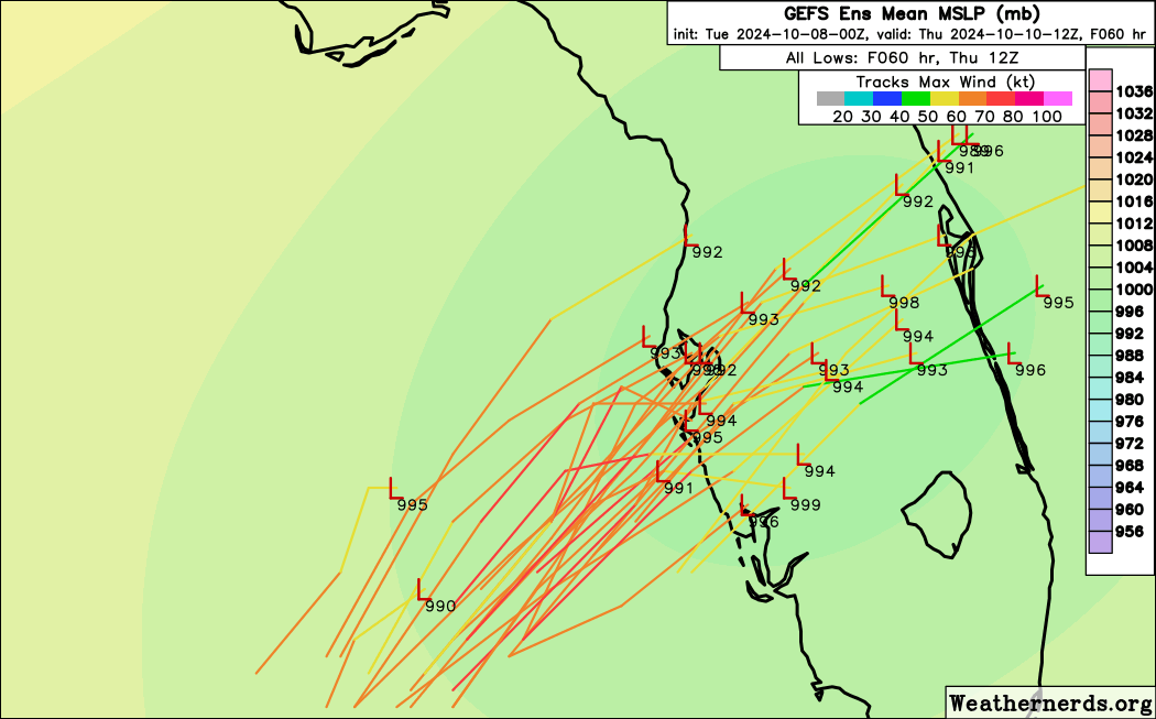
0z GEFS and EPS tracks


-
GEFS mean south of TB. Significantly so from 6z.
-
The 6z was tough to wake up to today. We’ll see what tomorrow brings.
-
GFS landfall Anna Maria Island. South of 18z. Brutal for longboat Key, Sarasota, Siesta Key. Impacts down to Port Charlotte. Shift doesn’t look like much on the plot but it matters for Tampa.
-
ICON landfall just south of TB early AM Thursday. 960s Relocated from one block from Hillsborough Bay in South Tampa to a nondescript hotel in Lutz.
-
HAFS-B landfalls early Thursday AM at Ft DeSoto/St Pete. 963 Heading out to evacuate inland. Really appreciate the pros and advanced hobbyists that have and are providing analysis and explanations in a digestible and fact-based way. It's been really helpful to understand and plan for Milton. Best of luck to all in the path, get out of the way and be safe.
-
18z GFS is over TB early AM Thursday. Landfall position is south of 12z.
-
South of TB, similar placement as 12z Euro.
-
Not surprised, and assume it could go higher in the segment just south of landfall. For a Pinellas or Pasco County landfall north of TB, the downtown corridor of the City of Tampa itself will be severely impacted, from the surge and flow from the Hillsborough River.
-
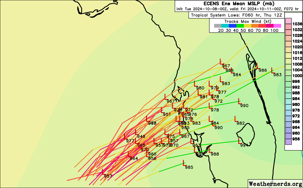
EPS mean appears to stay south of TB. Panel resolution not great but it’s definately on the southern side.
-
12z Euro a bit north and mostly aligned with hurricane model landfalls. Devastating outcome for TB and south.
-
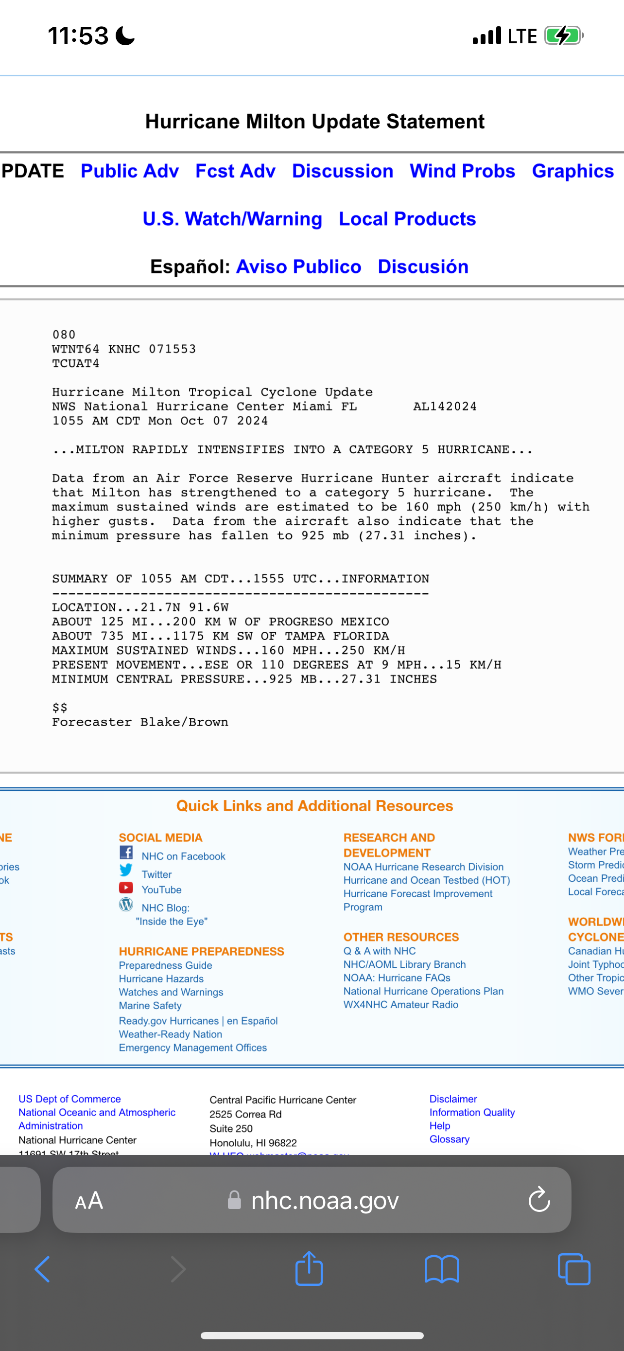
With a Cat 5+ surge.
-
Wow that GFS op run is brutal not only for TB but up the Nature Coast and inland.
-
GFS off Clearwater late Wednesday 955.
-
12z models rolling out. ICON approaching TB landfall Wed evening at 966
-
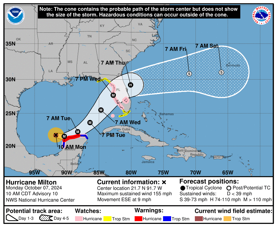
NHC track shifted north, right over TB. Not the update I wanted for MBY, but is what it is.
-
https://x.com/webberweather/status/1843301099454787848 Eric Webb: The thing that really concerns me w/ Hurricane #Milton's unexpected bout of explosive intensification this morning is the fact that this storm will now have **a lot** more time to churn & push water/storm surge onto the west coast of Florida in a few days. If you want a reasonable worst case scenario for Hurricane #Milton's maximum *potential* storm surge in/around places like Tampa Bay, take the current 8-12 foot storm surge forecast & double it.
-
https://yaleclimateconnections.org/2024/10/best-and-worst-case-hurricane-scenarios-for-tampa-bay/ Excellent piece from Dr. Masters. Milton impact scenarios for TB, along with references to the more extreme/unimaginable outcomes from maxed out scenarios. Was not thrilled to see this: “The HAFS-B model outperformed all the other models for 3-, 4-, and 5-day forecasts last year.”
-
All the hurricane models give TB a version of worst-case surge scenarios. HAFS-A puts me directly in the NE eyewall winds and surge, a few miles N of MacDill AFB and a block back from Hillsborough Bay.
-
Those of us in the path of the current 8-12 foot surge forecast (maybe higher?) prefer to avoid it, but it only shifts the devastation elsewhere.
-
HAFS-B peaks at 902 and landfalls near Tarpon Springs night early AM hours Thursday. HMON peak 921