SENC
-
Posts
910 -
Joined
-
Last visited
Content Type
Profiles
Blogs
Forums
American Weather
Media Demo
Store
Gallery
Everything posted by SENC
-
It is unclear if Wilfred still exists, and if so, exactly where it is located. Although there is clear evidence of a broad elongated circulation, the formerly small center of Wilfred is either obscured by higher clouds or has dissipated. AMSR-2 microwave imagery at 0431 UTC showed only evidence of a northwest-southeast oriented trough with one or more embedded mesoscale lows. Visible imagery and the next round of ASCAT passes will hopefully provide more information about Wilfred's status later this morning. The intensity remains 35 kt based on ASCAT data from last night, but more recent Dvorak estimates are lower. Due to the uncertainty associated with Wilfred's status and location, the motion estimate is a very uncertain 295/15 kt. In general, Wilfred or its eventual remnants should continue on a west-northwestward heading today, and then could turn westward by early Monday. The NHC forecast is very similar to the previous one and lies near the middle of the guidance suite. Virtually no change has been made to the official intensity forecast. Wilfred will likely gradually weaken until it dissipates due to a combination of increasing wind shear and a dry environment. The exact point at which Wilfred will become a trough varies from model to model, but confidence is fairly high that Wilfred won't last much longer than another day or two. The NHC forecast carries Wilfred for 48 h based on persistence from the previous advisory, but if recent trends hold, it could dissipate as soon as later today. FORECAST POSITIONS AND MAX WINDS INIT 20/0900Z 15.0N 42.0W 35 KT 40 MPH 12H 20/1800Z 15.7N 44.1W 35 KT 40 MPH 24H 21/0600Z 16.2N 46.5W 30 KT 35 MPH 36H 21/1800Z 16.5N 48.5W 30 KT 35 MPH 48H 22/0600Z 16.7N 50.3W 25 KT 30 MPH 60H 22/1800Z...DISSIPATED
-
5 Days without Rain & tolerable temps? I'll gladly take it.. Even Muh Rice Paddy was "drowning"
-
Good Morning My fellow Weather Nerds! I hope everyone is Loving this "Pattern change", (I know I am).. NO, the Fish are NOT "running" yet.. (Spots & Kings etc..) Current Conditions.. (On the Beach) Water Temp currently is.. 82F Winds are from the North @ 10-15 gusting to 24 mph Swells (waves) are at 4' to 5' from the ESE and Sloppy.. ICW condition(s).. Low of 57F High of 67F, 73F, forecasted for today Pressure 30.23 in Partly Cloudy w/Visibility 10 miles Dew Point 53 F Humidity 75 % Precipitation 0.00 inches The Weather went from 95 to 55.. Like it saw a State Trooper..
-
Well, this *tweet* aged well.. (The) Hybrid low west of Portugal have LOW (re)formation chances..
-
Let me try, see if this works.. Image link, (shear overlaid w/Water Vapor) http://tropic.ssec.wisc.edu/real-time/storm.frame.php?&basin=atlantic&sname=98L&invest=YES&zoom=8&img=5&vars=1010100000100000000000000&loop=0&llval=
-
Lordy,, Orangeburgwx, I wouldn't have figured you to be a "Race Fan".. That said... Back to Wilfred.. Going with the Theme of It's being 2020, Unexpected things have Happened that Surprised ALL of US, Forcaster(s) AND the NHC.. In the Weather Forecasting World.. (Remembering Laura & Sally & Isaias).. I believe We had better to expect the Unexpected.. Shear, Hispaniola Shedder, Upwelling, TUTTS, Throughs, are seemingly NOT having the "expected" effects, of "dissipation", weakening, or what-have-you. I think We can expect the same with, Wilfred.. I read the NHC Disco, the last two paragraphs were so much "Word salad", I mean, it seems even the NHC is not quite sure what to exactly expect.. Along with the Models, Not having a firm grasp on the future evolutions of this years TC's.. I honestly don't expect Wilfred to fully "dissipate, My "reasoning"??? It's 2020 after all.. Of course 22L.. Failed post race inspection
-
Well,, that escalated quickly.. Edited Thread Title, to reflect, updated NHC choices..
-
SURFS UP!
-
After this Hyper-Active Tropical Hurricane season,, Going into Fall/Indian Summer.... (Short Lived).. Wouldn't it be "On par" with 2020,, To get a YUGE Blizzard , about Mid-Late October/Early to Mid-November time frame, covering the WHOLE State of NC, et al? Several feet,, in the Mountains, to 12++ inches all the way down to the Coastal Area(s)?? THAT would put a "Night Cap" too 2020 for the Southeastern Forum, Don't cha think?...
-
T-Storm(s), Very heavy, RAIN ATM, with Pea sized Hail, Lotsa Lighting & Thunder, (currently).. Winds outta the SW-SSW at 18 mph, gusting to, (peak wind gust(s) 56MPH !) .. Here on the ICW.. We are under a Tornado Watch(s).. Temp: 75F Pressure: 29.8 in Visibility: Almost ZERO Dew Point: 74 F Humidity: 91 % Rainfall :0.33+++ (adding (ALOT) more ATM VERY HEAVY Precip)..
-
Tornado watch,, in My area(s) just received the Alert.. Skies here look,, so 2020 Ominous..
-
Pulls a "Florence", landfall coming from the NE, or Westward bound, (somewhere) from Maine to the Virginia/Carolinas Border... it IS 2020 after all..
-
Picked up about 3.5 +/- inches of Rain yesterday.. High 78F Current Temp 80F w/ .08 inch today in the bucket thus far..
-
Getting some pretty "wicked" Bands of T-storms coming onto the Coast ATM, Cloudiness & steady "light rain" started this afternoon, Now getting T-storms, coming off the Ocean, Heavy rain/Wind(s) & lighting..
-
Sorry for the edit, Kinda "confusing" with all these Invest's/Depressions/storms/Canes that are currently active..
-
8PM update.. An elongated area of low pressure located a few hundred miles south of the Cabo Verde Islands is producing disorganized shower and thunderstorm activity. Environmental conditions are expected to be conducive for development during the next few days, and a tropical depression could form before upper-level winds become less favorable over the weekend. This system is forecast to move west-northwestward at 10 to 15 mph during the next several days. * Formation chance through 48 hours...medium...40 percent. * Formation chance through 5 days...medium...60 percent.
-
Quote..
-
Wink~Wink..
-
i'm calling for Cat 5 Winds AT Flight level , (10K feet), with Cat One effects..
-
Meh, I'll be pleasantly Surprised..
-
My extreme apologies @ Our ever vigilant MODS.. I'm trying, or WAS trying to convey,, that during Isaias, It came ashore, (landfall), during High tide.. WE ALL saw here on AmericanWx, What happened the few final hours leading up to "Landfall".. I'm at about, 30 +/- feet elevation, Where I reside on the ICW, HERE @ Riches Inlet.. The next morning, I went down to the ICW,, Marsh Grass & Debris was deposited as high as 12 feet ABOVE the High tide line.. Of course OIB & Southport fared even worse.. That said,, Isaias was just Barely a Messy, CAT-1,, quickly getting organized just before landfall.. Storm Surge Took Everyone by surprise! DO NOT discount, Storm Surge with Laura.. (Look,, I'm NOT trying to Hype this upcoming event).. Though a Intensifying Hurricane, Forecasted, By OUR Modeling,, possibly into a Strong Cat-2 or greater,, coming ashore (landfalling).. Should NOT,, be discounted for "Storm Surge" ATM, coming, making Landfall during a Rising High Tide(s).. Across the Area(s) affected.. That is ALL, thank you for understanding.. Mods.. (and everyone else reading this)...
-
@NavarreDon, Imagine.. Your now, (ground(s)) are extremely saturated, and then.... Having a hurricane ,, Or a very strong TS,,, landfall.. LOTSA trees/power poles.. (ad-Infinium) etc are going to come down! You have a Generator right?
-
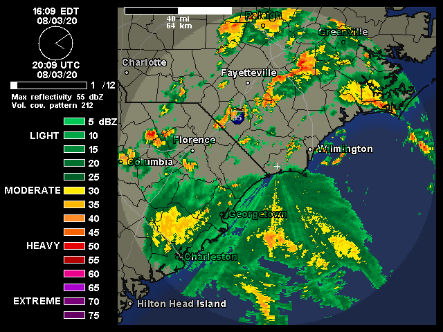
May I please "comment" on this Code yellow , I've not really mentioned this, just "observations" via Radar/Nexrad, It's been, how can I say? Almost a Homebrew? system thats been just off the coast now,, for several days, bringing Numerous Showers & T-storms across My area, here on the coast.. You could actually "see" the cyclonic Motions on Radar, (the past 3 days),, though I've NOT said anything, being a Weather weenie & all that.. interesting,, nether-the-less, for a possible "homebrew" system.. Maybe @shaggy & @downeastnc, can chime in Since they are also close to "Coastal" areas here in SENC, abit just north, closer to Morehead City.. It's downright TROPICAL HUMIDITY, right now here just north of Wilmington..
-
Bring it, Ready for FALL FISHING! here on the Coast!
-
Can I assume, that some of this is, "interaction" with the incoming Trough? I'm gettin downpours like in the #ChinaFlooding