eduggs
-
Posts
5,950 -
Joined
-
Last visited
Content Type
Profiles
Blogs
Forums
American Weather
Media Demo
Store
Gallery
Everything posted by eduggs
-
Sussex to northern Fairfield is just pounding! Missed the big totals by about 20 miles here in central Morris. Still was a fabulous morning.
-
The hi-res NAM is showing several hours of light snow tomorrow morning - with light accumulations. Couple inches up the HV but even something down to NYC and LI. Not much support from other guidance but it would be an enjoyable ending.

-
Awesome! Getting north of the mix line was key. Looks like you should pick up several more inches.
-
90% sleet over the past 30 minutes. Measured 7.5" at 11:30am and 10" at 3pm. Not much accumulation after 1pm or so. Still showing 10" new so probably some compaction going on because of the sleet.
-
Snow sleet mix in central Morris at the moment. Vis. is higher for the moment... fluctuates with the % of snow.
-
I miss the days when people used the NCEP page for QPF, 925/850/700 temp, 850/700RH & omego, and 500mb heights. The snowmaps from Pivotal and TT that get thrown around online have really caused a dumbing down of meteorology.
-
Yeah looks sweet for several more hours. Enjoy! Shame about the dryslot... hopefully there is some wraparound tomorrow morning.
-
Remember that Pivotal or TT clown maps show the ptype colors based on model output and a ptype algorithm. If sleet is shown on Pivotal that doesn't mean the model precludes a mix of snow and sleet south of that line. And yes the HRRR has done a good job of sagging the mix line south. It also has the benefit of being run every hour.
-
I'm not complaining. As I've mentioned, I've spent most of the day outside enjoying the snow. I'm defending the viewpoint that the NAM and its successor the RRFS did very well with this storm. It's discouraging that people have come to believe that 3rd party vendor clown maps represent the actual output of the weather models. This idea needs to be challenged so that it is dislodged from the collective understanding.
-
Sleet briefly made it to Rockland and will probably mix in pretty far north as the dryslot approaches. The CMC and UK showed several runs where the mix line stayed south of the metro entirely. Even this afternoon's runs may not have mixed at all. Terrible!
-
Show me where I said that.
-
Exactly. People forget. This was talked about as a snowpocalypse for days. NWS was 15"+ for most of the area until really close in. I really hope the tail end of this overperforms. But so far great call by you!
-
No. I have been confident about warning snow everywhere. I've also been confident about Putnam/Orange getting 12" plus. I've said numerous times I thought the battleground for double digits would be across southern Westchester extended east and west. This morning appeared to overperform either ratios or QPF. But the progression of the mix line played out very similarly to how the NAM depicted going back several days.
-
You're getting fooled by Pivotal weather. Use QPF and temperature at available levels (700mb, 850mb) plus an estimate of ratios to guestimate snowfall.
-
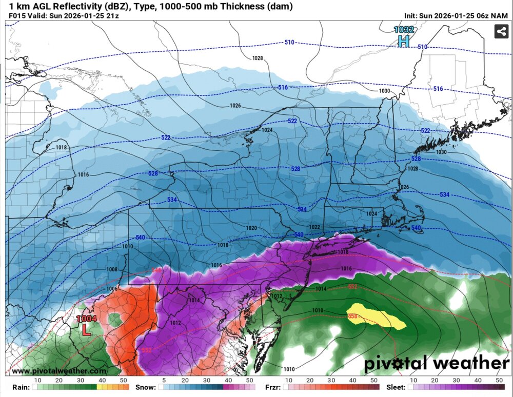
I just checked the 6z model runs. For NYC by 21z the NAM had about 0.87" liquid and the RGEM had 0.93". Almost the same. People are just getting fooled by the Pivotal clown map algorithm. Clown maps are really bad for the weather industry. They skew the data and lead to rampant misinterpretation.
-
I'm looking out my window and it's 100% sleet right now. The NAM won. No other model was as fast or as far north with the mix line. Same thing in DC and PHI. People need to learn the difference between a CLOWN MAP and model output. Prior to 2010 or so this was not a problem. People used NCEP QPF and temperature maps. Hobbiest were better forecasters.
-
THE NAM DOESN'T FORECAST SNOW.
-
If you believed the global models from 36 hours ago... ECM, UK, GFS, ICON, CMC - all of them - you would think it should be all-snow throughout the NYC area right now. The NAM is just really good at sniffing these out.
-
The NAM was the first model to bring sleet to our area and eventually most of NNJ and southern Westchester. Eventually all other guidance followed suit. It was the earliest to mix today and it was RIGHT. All other guidance was WRONG. PIVOTAL CLOWN MAPS DO NOT EQUAL THE NAM FORECAST SNOW ACCUMULATION. People seem to be clueless about interpreting model output. UK, GFS, Euro were way too late and south with the mix line.
-
Hats off to the NAM model on the sleet timing. It won again. If it was a little light on the QPF before the mix, most guidance was. Now let's cool the mid-levels and flip back to all snow. Radar looks amazing for the Hudson Valley region!
-
I was out on a ski tour for several hours. The snow is much denser than I would have expected. It was fluffy before 9am and then increasingly dense. I don't think ratios have been great since this morning. After 12pm I began noticing melted flakes foretelling mid-level warming. It's been going back and forth between various combinations of snow and sleet since 1:45.
-
Sleet began mixing here at 1:45 - right on time. Sleeted for about 30 minutes with >2mi vis then parachute flakes fought back and now moderate snow with low vis. again! 10" new and 12.6F
-
Extreme Cold, Snow & Sleet: SECS 1/24 - 1/26
eduggs replied to TriPol's topic in New York City Metro
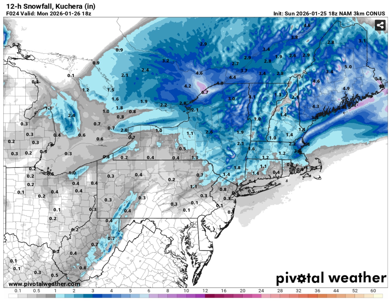
These are the big boy rates right now. There might be higher QPF hours coming, but probably not higher snow/hr. -
Like the mid-Atl board earlier this morning, the Philly board is now reporting that the NAM did best with mixing line/timing.
-
Extreme Cold, Snow & Sleet: SECS 1/24 - 1/26
eduggs replied to TriPol's topic in New York City Metro
I'm seeing 18"+ for parts of the mid-HV across to CT on the latest guidance... maybe down to Orange & Putnam... especially if measuring with a snowboard every 6 hours.