eduggs
-
Posts
5,128 -
Joined
-
Last visited
Content Type
Profiles
Blogs
Forums
American Weather
Media Demo
Store
Gallery
Everything posted by eduggs
-
We'll see how Wed night goes. And obviously the month just started. But I can see a way that December ends up less snowy than November for a lot of the NW suburbs. Long range modeling suddenly looks shockingly bad for snow.
-
ECM says welcome to the worst December weather since 1988. Cold & dry, rain, Cold & dry, rain, rain, Cold & dry, rain...
-
Another day, another shitty model cycle. It's been all down hill since a snowy, Friday November 22.
-
December 2024 - Best look to an early December pattern in many a year!
eduggs replied to FXWX's topic in New England
That's cause there's only about 8 hours of daylight this time of year. So chances of daytime snow are low -
As expected, the 18z GFS shifted towards model consensus for the 10th and beyond and away from a wintry threat. "Pattern" is a misused and misunderstood phrase, but if we want to grossly generalize things then we can say this "pattern" or orientation and evolution of the synoptic flow field does not look to be very favorable for snow locally.
-
As soon as someone in the SNE subforum posted a thread about the best early December pattern in years, snow prospects for us fell to shit Those guys are generally too optimistic about future patterns that are just beyond the horizon. Same story for the past few years. But that is born out of a series of good years in the 2010s and significantly more margin for snow in NE compared to the northern mid-atlantic.
-
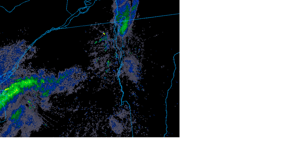
That's awesome about the semi-continuous snow up there. Those periods are the best when you never know how much snow will fall and for how long. The Green Mountains clearly block the radar beam in that region, which makes local observations all the more critical. Modeling seems to have correctly predicted an extension of the Lake Ontario LES band into the northern Greens. But since there was little on the NY side, I gotta figure that the snow at low elevations on the VT side was due to either Champlain enhancement or some kind of low level convergence.
-
December 2024 - Best look to an early December pattern in many a year!
eduggs replied to FXWX's topic in New England
Can be insufficient saturation in the snow growth region, lack of nucleation, temps too warm for crystallization etc... If conditions aren't sufficient, you get supercooled rain drops and then ice pellets instead of snowflakes even if the temperature is below freezing. But that sounding looks like snow or mostly snow. -
Most likely outcome IMO. Pray for a snow squall Wed night.
-
Sign me up for the 12z GFS. Some snow to long duration frozen mix. Nice trof axis and pretty cold surface. But unlikely outcome.
-
12z GFS is pretty interesting around the 10th. That would probably work. But it's a long way off and too much run-to-run variability to have any confidence. The threat for the 8th keeps decreasing in likelihood.
-
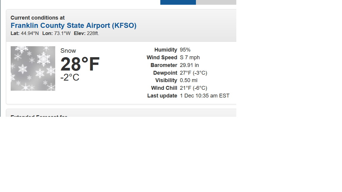
Is that persistent band near Franklin County Airport in Vermont typical with these setups? It looks like some Lake Champlain enhancement from the Ontario LES band. The low elevation also probably enhances the reflectivity relative to the terrain due to better line-of-sight. I feel like I've seen that feature before, but I don't usually look carefully for it. There doesn't seem to be any mention in the NWS BTV forecast. Kinda cool.

-
December 2024 - Best look to an early December pattern in many a year!
eduggs replied to FXWX's topic in New England
Well first week and probably into second week of December looks below normal. And you have to weigh the nearer term more heavily based on lower forecast skill in the long term. The second half of December could be average to slightly above and you'd still end up with that monthly temperature forecast in the northeast. -
18z GFS is a sweet run for coastal Maine and SE NH and pretty intriguing for EMA and the rest of New England for the Dec. 8th potential event. Too late for us. But it demonstrates potential for rapidly translating a flat mid-level shortwave into a deepening cutoff with SLP capture. Eastern New England is clearly favored and there still isn't much inter-model support, but at least it's something to watch.
-
Me too. I think north of I-287/I-80 has a 50-50 shot at 1". South of there will be tough. We're going to need some luck.
-
We need more STJ involvement. Or we need a ridge axis further west with the s/w for the 8th diving further southwest. As is, the modeling is not close. Any cyclogenesis would happen too late outside DE Maine and the Maritimes. If the STJ links with the follow up wave around the 10th, chances increase for rain. Low expectations are advised for now.
-
12z GFS and CMC not very good. Still barely trackable threats. The lead up to the elevation event a week ago that delivered accumulations to southern Westchester was far more interesting.
-
Winter is too short for patience. We will only have a few windows of time where we can get snow locally. Treasure every snow shower.
-
The next 10 days looks to favor New England, and Maine in particular if ensembles are to be believed. Positive 500mb anomalies make it as far east as MN, which creates a steep NW flow angle that doesn't usually deliver us much precipitation. Maybe something changes moving forward. It wouldn't take too much to get some snow showers at least. Web cams from ALB to Glens Falls look nice today. But it always seems like it's snowing somewhere else.
-
December 2024 - Best look to an early December pattern in many a year!
eduggs replied to FXWX's topic in New England
Yes we all agree 10:1 is arbitrary. But if a chart specifically defines the output as representing a 10:1 liquid to snow ratio, the model just needs to get the ptype and QPF correct. The snow map is just a visual representation of data... like a graph or plot. It's not a forecast. -
December 2024 - Best look to an early December pattern in many a year!
eduggs replied to FXWX's topic in New England
A factor of 2 is a big difference IMO when people still post SV maps on this board and then you start referencing those maps. Go check how StormVista compares to Pivotal or TropicalTidbits or whatever others are out there in terms of snowfall. Yes 10:1 is an arbitrary starting point. But if you don't get that part right, your starting point makes it hopeless to even be in the right ballpark. -
December 2024 - Best look to an early December pattern in many a year!
eduggs replied to FXWX's topic in New England
You and your dumb ass buzzer are confusing yourselves. Whether a 10-1 ratio is correct is irrelevant to the point. When a snow map shows "total snowfall at 10:1", the primary model parameter in question is QPF, not accumulated snow. The secondary model parameter, which is often calculated by 3rd party algorithm, is ptype. If a model correctly predicts QPF and ptype, a snowfall map that multiplies liquid equivalent by 10 and displays it as total snowfall at 10:1 would be absolutely correct. It just might not be an accurate prediction. Some 3rd party maps do this task pretty well. StormVista does not. -
December 2024 - Best look to an early December pattern in many a year!
eduggs replied to FXWX's topic in New England
Obviously all snow maps are coarse approximations because many factors affect snow accumulation. But some algorithms are semi-accurate at identifying ptype under most conditions and then multiplying QPF by 10. StormVista is different. It will show 4" of snow based on 2 tenths of liquid and a min temps of 37F. StormVista snow maps are garbage and distinctly worse than most other maps. This is a relatively simple and hopefully non-controversial point. -
December 2024 - Best look to an early December pattern in many a year!
eduggs replied to FXWX's topic in New England
No. Some snow accumulation maps accurately convert modeled liquid precipitation to snow at a 10:1 ratio. StormVistaWx does not. So it's in a different category altogether from other so called clown maps. Hopefully this is understood when people consider what they would take in terms of fantasy snowfall.