

eduggs
-
Posts
5,128 -
Joined
-
Last visited
Content Type
Profiles
Blogs
Forums
American Weather
Media Demo
Store
Gallery
Everything posted by eduggs
-
The HRRR is a dangerous tool, highly susceptible to wishcasting. 500mb on the HRRR would be helpful to guard against model field hallucinations, but I don't think that parameter is available.
-
To me if looks like the lowest surface pressure is a couple of mbs lower on the western lobe and a couple higher on the eastern. Pressure field looks otherwise very similar to 18z when I toggle between them. The biggest difference I see is a bit more precipitation NW of the low. It's a good shift but still looks minor to me.
-
The pressure field doesn't look too different to me. Precip. field too. The placement of the L on the map can be misleading. The pressure field is like a topo map of terrain elevation with ridges and peaks. There isn't always one solitary summit. It looks like a minor shift to me... typical run to run variation. But I'm hoping for a positive surprise.
-
December 2024 - Best look to an early December pattern in many a year!
eduggs replied to FXWX's topic in New England
It's an unsexy dampening wave, but there's a good antecedent airmass. The high QPF signal on the GFS catches my eye. Recent runs were fairly wet as well. -
There's a pretty decent QPF signal for the damping wave(s) Dec 24-26 on the GFS. Warm front pushing into entrenched cold air. The ECM and CMC have it too, but slightly drier. Kind of an under the radar threat, but it's something to watch.
-
December 2024 - Best look to an early December pattern in many a year!
eduggs replied to FXWX's topic in New England
The GFS has been throwing some pretty significant precipitation into the cold air Dec 24 - 26. ECM and CMC to a lesser extent, but with a similar idea. Wherever the warm front boundary sets up could get some sneaky good snows (and/or ice) around Christmas. Early guess would be CNY through CNE. Still way out there though. -
12z GFS was pretty f'in close for EMA and esp EME. If that NS wave can dive south from ON and phase a little faster it could work out OK for parts of SNE. Not much time though. Can't have any set backs over the next few model cycles.
-
Nice little Xmas snowstorm on the 12z GFS just north of NYC. The GFS has been hinting at this kind of setup for several runs with limited support from other models. As shown it's an unlikely outcome, but something else to watch. As yesterday morning's short duration, moderate snowfall across parts of the LHV demonstrates, with cold air in place it doesn't take a perfect setup to get a beautiful wintry scene.
-
Drove through the Hudson Highlands this morning and there was an impressive snowcover around the West Point area. It must have really pounded early this morning. It wouldn't surprise me if there were a few spots up there that got 5 or 6 inches of snow.
-
Missed another one. No snow between Morristown and Montville. Well maybe a light dusting of snow/ice on the mulch. I think the CAD held the cold along and to the west of the terrain fall line. So snow was basically confined to west/north of I-287. Pretty well modeled actually except slightly more snow than ice compared to the progs... although observation yesterday from down in MD and PA suggested a slight overperformer with respect to ptype.
-
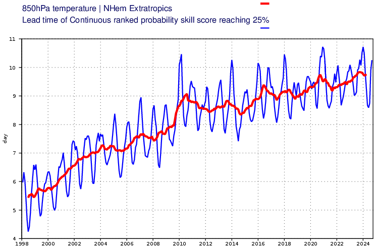
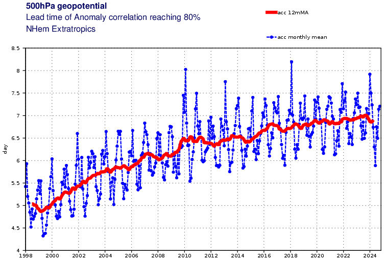
Weather model improve every year. Verification is significantly improved since 2004. Regional synoptics are well resolved out to 5 days, whereas 20 years ago that was fantasyland territory. Surprise storms are a rarity these days. Here are a couple of graphs of two verification parameters for the ECMWF. Other models may have improved more or less than these scored parameters indicate.
-
That area of vorticity in the southeast might play a role in antecedent downstream ridging, but to me the bigger factor is to the north. The key trof/shortwave diving SE from the Dakotas towards the Ohio valley has to be on the downstream side of the longwave trof and/or the polar jet trof up in Canada for it to deepen and take on a negative tilt. On the GFS, the main shortwave is on the upstream side of the polar jet trof until too late, delaying the phasing process and subsequent cyclogenesis until the wave is well east of our longitude. On the ICON, and especially on a few wrapped up runs over the past few days, the key shortwave was positioned upstream of the polar shortwave diving sse-ward through Ontario. This timing and positioning of waves is key to amplification.
-
The largescale features are supportive of a wintry event around the 21st as everybody has been saying for days. But unlike with the recent and upcoming rain events with single waves traversing W to E, the synoptic details of the weekend event and the angle of trof approach require excellent timing with wave interaction. That factor would seem to make a positive outcome unlikely. By memory it seems like these tend to work out best for eastern NE.
-
Yeah. The ensemble spread reflects the uncertainty. But with the improvements to mid-range models, we probably only have another 24 hours to see improvements before the approx. final outcome starts to be resolved. I don't like the trends over the past few days towards a faster progressing, lower amplitude trof. And there are fewer and fewer deep individual members on the ensembles.
-
The wrapped up solutions that deepen and cut off near out latitude have multiple northern stream shortwaves phasing. The 12z ICON has a piece of energy giving south from Ontario late in the game. A well timed interaction between shortwaves will lead to rapid tilting and deepening of the ULL. But if it isn't well timed, the result will be a clipper or squashed system.
-
Extended summer stormlover74 future snow hole banter thread 23
eduggs replied to BxEngine's topic in New York City Metro
Ha Ha, yup! Almost all sightings can be attributed to airplanes, helicopters, and starlink satellites. New Jersey, and in particular northern NJ near the epicenter of reported drone activity, is an extremely high density commercial airspace with planes from Newark, JFK, LaGuardia, Teterboro, Morristown, Essex Co., and Westchester Co. all criss-crossing the area. At certain times there are at least a dozen aircraft visible in the sky from some vantage points. -
12z ICON looks pretty interesting for the 12th. GFS a little less so, but still highly trackable. I'd like to see the thermal boundary get pushed southeast Sat - Mon so we at least have a chance at wintry if a shortwave can round the longwave trof and iniatiate a southeast low and eventual coastal SLP. The ICON at least is almost there.
-
Some nice radar returns streaking from central IN through OH. I don't think much is reaching the ground though. IF the models are underrepresenting this virga/precip, it could boost QPF slightly this evening across NEPA, extreme NNJ, the mid-HV, over to NWCT.
-
IF the ECM is close, we have a great week of model tracking ahead of us: Excellent trof alignment, STJ and polar jet phasing, shortwaves diving south through central US with fresh cold air, high pressure over upper midwest, moisture surging from the Gulf, and low SLP in the southeast. Oh how we dream. I'm pessimistic about this potential threat until we get multi-model and multi-cycle runs that are close enough to a wintry threat without huge run to run changes.
-
The increase in temperature is also disproportionately distributed towards the winter and geographically towards the higher northern latitudes. Plus the oceans have absorbed a good deal of the heat energy, which is just recently starting to have a noticeable impact. That has definitely shifted the mean winter climo a few degrees N in latitude.
-
In the interest of trying to be positive, there is a ton of vorticity passing through over the next day or so. That means it's always possible to get a burst of precipitation and an unexpected surprise. There could be multiple periods of precipitation... though somewhat widely scattered and favoring west facing terrain. From what I can tell looking at soundings, some ptype algorithms that show rain reflect lack of saturation in the snow growth region as opposed to a warm boundary layer.
-
FWIW, the 6z ECM didn't look bad for a possible 12/12 coastal threat. The 12z GFS also isn't completely hopeless. ICON too. The CMC needs work but I can see a path. Overall the 12z cycle gives a glimmer of hope. Ensembles anyone?
-
The meso models are not enthused about snow prospects Wed night. Maybe they will be wrong and the snow shield will be more widespread, but I doubt it. Downsloping off terrain with a SLP to our NNW rarely works out. Best chance of whitening the ground will probably come with scattered instability snow squalls on Thurs. morning.
-
Both the GFS and NAM look good for a C-1" of snow Wed night through Thurs. morning. Maybe 2" N&W for a few lucky spots that get some squalls on Thurs. the CMC, ICON, and 18z ECM don't show much snow for our area. It looks like at least two periods of precipitation. An initial burst with intense frontogenesis Wed night and then possible squalls early Thurs. The GFS and especially NAM are surprisingly wet in CT. If the wetter models are right and some of that works back into SENY and NENJ, it could be a fun night. Temperatures start chilly and get very cold aloft (i.e., steep lapse rates). But I won't really believe the snow threat until the ECM comes on board. Either way, the hills of interior CT and MA and esp. southern VT should get a few to several inches of snow.
-
December 2024 - Best look to an early December pattern in many a year!
eduggs replied to FXWX's topic in New England
I agree it probably is related to ocean heat content and continental/terrain-ocean interactions... plus the steadily strengthening geostrophic wind due to stronger temperature gradients. It's probably a feature that will become increasingly persistent in time due to planet warming.

