Chicago Storm
-
Posts
19,240 -
Joined
-
Last visited
Content Type
Profiles
Blogs
Forums
American Weather
Media Demo
Store
Gallery
Everything posted by Chicago Storm
-

Spring 2022 Medium/Long Range Discussion
Chicago Storm replied to Chicago Storm's topic in Lakes/Ohio Valley
There will be several days with severe potential in the Midwest next week. -
Spring 2022 Medium/Long Range Discussion
Chicago Storm replied to Chicago Storm's topic in Lakes/Ohio Valley
well, it would be well above normal. maybe the warm front will stall at the border and you can sit in the 40’s all week instead. -
Spring 2022 Medium/Long Range Discussion
Chicago Storm replied to Chicago Storm's topic in Lakes/Ohio Valley
7 consecutive days of 70’s/80’s around MKE is the new ‘squashed south’. in the words of alek, tth. -
Spring 2022 Medium/Long Range Discussion
Chicago Storm replied to Chicago Storm's topic in Lakes/Ohio Valley
how’s that working for you now? that’s why it’s ENS>OP at this range for overall pattern recognition. -
Spring 2022 Medium/Long Range Discussion
Chicago Storm replied to Chicago Storm's topic in Lakes/Ohio Valley
As was expected, the cool/active Midwest/Great Lakes/Northeast troughing pattern has continued into the first week of May. The good news is...As several have recently alluded to we will be seeing another pattern flip coming up, and a significant one at that. This upcoming pattern will feature the best and most sustained spring conditions most have seen so far this year (I know that's not saying much). This new pattern will set in this upcoming weekend, continuing through next week, and then quite possibly into the following weekend (May 14/15th) as well. This upcoming pattern will be dominated by a -PNA/Western US trough, an Eastern Canada/Eastern US mean ridge, and a +NAO/Greenland area troughing. This pattern will support overall mild/warm temps for most and an active/stormy period as well.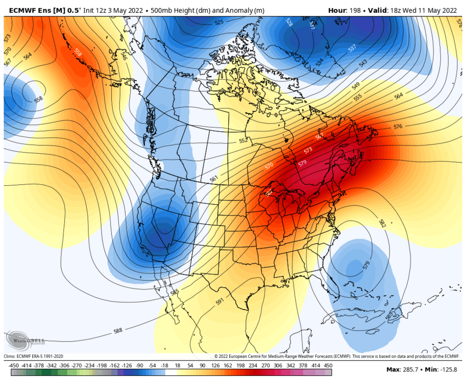
-
There's some lake enhanced rain in NE IL currently.
-
Spring 2022 Medium/Long Range Discussion
Chicago Storm replied to Chicago Storm's topic in Lakes/Ohio Valley
https://www.ebay.com/itm/154839724066?var=454947912027 -
Spring 2022 Medium/Long Range Discussion
Chicago Storm replied to Chicago Storm's topic in Lakes/Ohio Valley
palms are thriving down here. -
Spring 2022 Medium/Long Range Discussion
Chicago Storm replied to Chicago Storm's topic in Lakes/Ohio Valley
GEFS>GFS. -
I was wondering when some of you would start mentioning the positive flip we’re going to see.
-
2022 Short/Medium Range Severe Weather Discussion
Chicago Storm replied to Chicago Storm's topic in Lakes/Ohio Valley
This makes it the second consecutive year that there’s been a tornado within 15 minutes of home. -
2022 Short/Medium Range Severe Weather Discussion
Chicago Storm replied to Chicago Storm's topic in Lakes/Ohio Valley
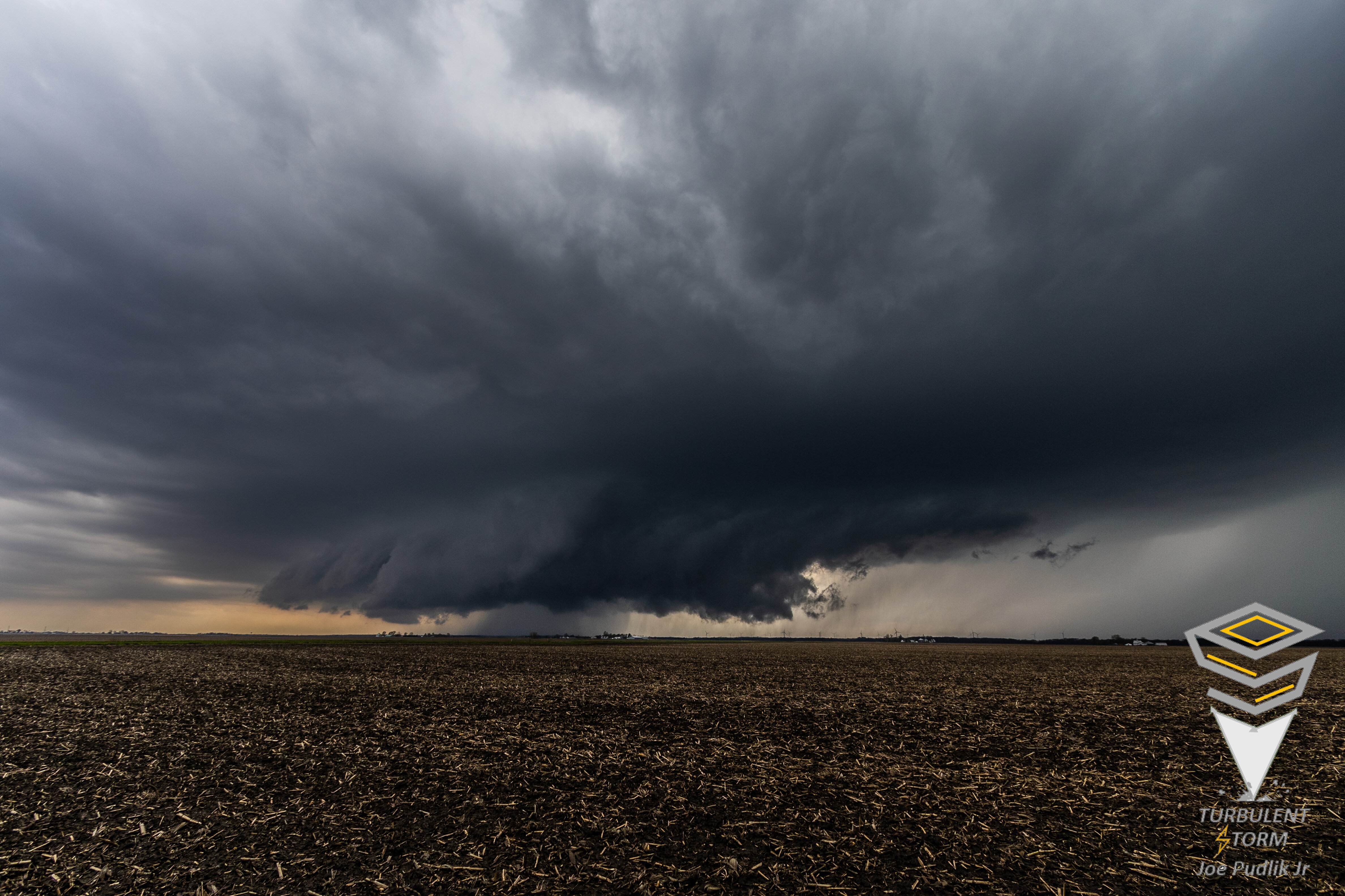
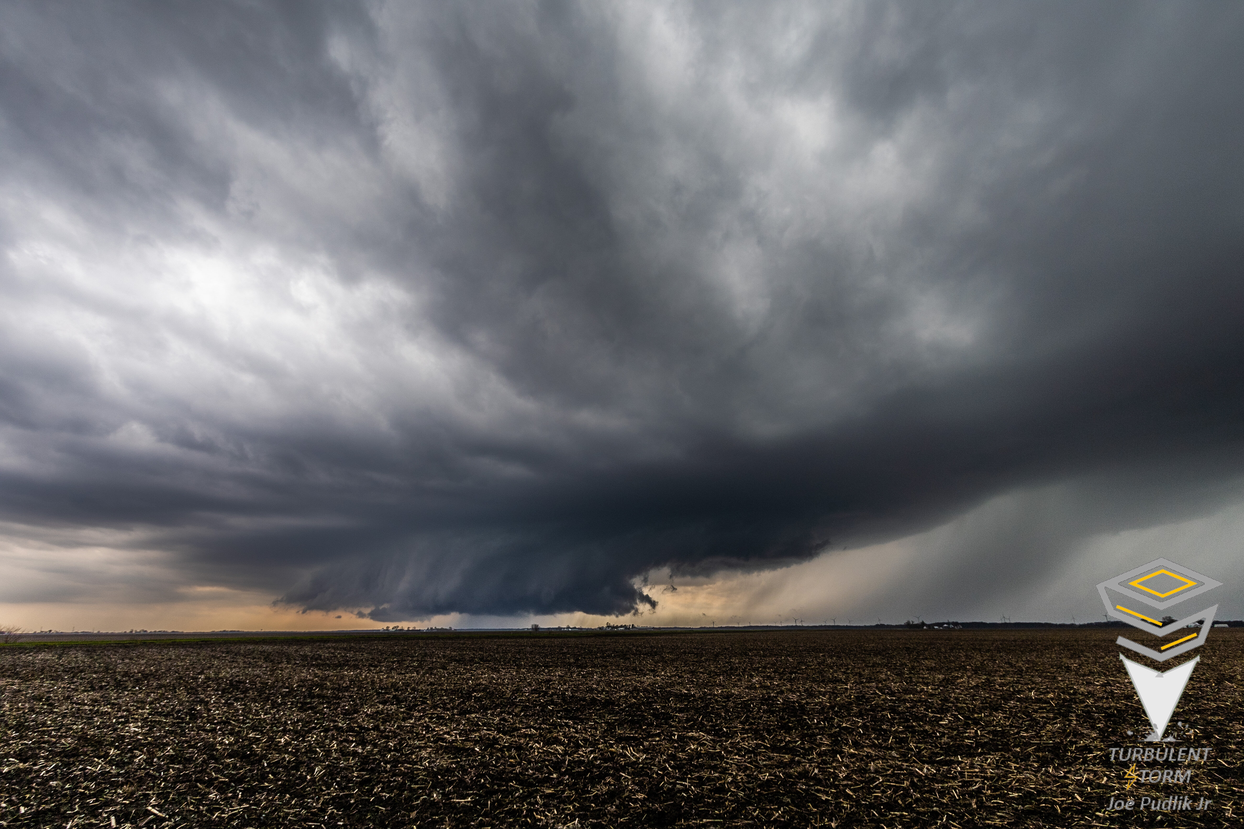
Ended up on the supercell t'storm near Dwight, IL yesterday afternoon. It did have a lowering for a while, and also had some visual rotation for a while (In addition to a couplet on radar as well). However, it never did tighten up and strengthen enough to produce a tornado. A few pictures of this t'storm are below. Ended up messing around with a few other severe t'storms after the aforementioned initial intercept, but did not end up with anything noteworthy.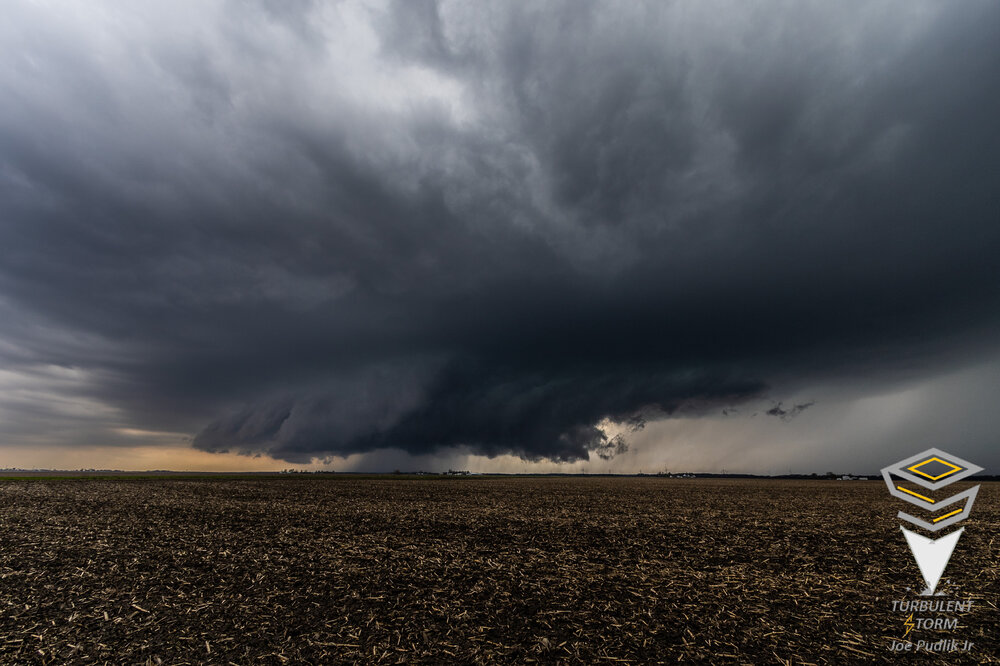

-
2022 Short/Medium Range Severe Weather Discussion
Chicago Storm replied to Chicago Storm's topic in Lakes/Ohio Valley
Significant capping still in place on the 18z ILX sounding. -
2022 Short/Medium Range Severe Weather Discussion
Chicago Storm replied to Chicago Storm's topic in Lakes/Ohio Valley
Personally, if I go when I leave ORD at 2PM, it’ll be somewhere between Rochelle and Bloomington. Maybe take the middle with LaSalle. -
2022 Short/Medium Range Severe Weather Discussion
Chicago Storm replied to Chicago Storm's topic in Lakes/Ohio Valley
Kind of getting the feeling that even though we are seeing a nice wedge of clearing/destabilization/warming/moisture return, this still may not perform. We’ll see if it’s a mirage/overthinking or not soon. SPC held on to slight risk with the updated SWODY1, which I agree with. -
2022 Short/Medium Range Severe Weather Discussion
Chicago Storm replied to Chicago Storm's topic in Lakes/Ohio Valley
Probably the best case scenario to start the morning in one of these situations… Fading convection is already to the I-39 corridor the length of Illinois, with clearing taking place behind this activity from the DVN CWA down into MO. -
2022 Short/Medium Range Severe Weather Discussion
Chicago Storm replied to Chicago Storm's topic in Lakes/Ohio Valley
One of the many times we have this issue each season. If that morning complex can clear out quick enough and clearing can occur in its wake for a while, the ceiling *could* be an enhanced risk worthy day. But at this point given 8/10 times things don't work out and also taking into account the present look of guidance, I'd roll with a marginal risk at this point to start. -
2022 Short/Medium Range Severe Weather Discussion
Chicago Storm replied to Chicago Storm's topic in Lakes/Ohio Valley
At this point tomorrow looks like a marginal risk worthy for portions of WI/IL/MI/IN/KY. -
Spring/Summer 2022 Complaint/Banter Hangout
Chicago Storm replied to IWXwx's topic in Lakes/Ohio Valley
-
Spring/Summer 2022 Complaint/Banter Hangout
Chicago Storm replied to IWXwx's topic in Lakes/Ohio Valley
No shot. What they’re depicting is nearly impossible. -
2022 Short/Medium Range Severe Weather Discussion
Chicago Storm replied to Chicago Storm's topic in Lakes/Ohio Valley
Very good points. Kind of interesting how that works, but my guess it has to do with timing of systems ejecting out from the Inter-Mountain West and into the Plains. Such as, if the Mountainous region in the West was further east, maybe that would have a chain reaction effect for bigger synoptic events in your area. -
Topped out at 83 at ORD, 85 at MDW and 82 at RFD today. Warmest temps and first 80°+ day since early last October.
-
2022 Short/Medium Range Severe Weather Discussion
Chicago Storm replied to Chicago Storm's topic in Lakes/Ohio Valley
You’re not missing anything at least. Tomorrow is as marginal as it gets. Activity from Friday might end up being better. -
Spring/Summer 2022 Complaint/Banter Hangout
Chicago Storm replied to IWXwx's topic in Lakes/Ohio Valley
Barely eek-ed out a W. -
Spring/Summer 2022 Complaint/Banter Hangout
Chicago Storm replied to IWXwx's topic in Lakes/Ohio Valley
70 seems like a stretch today. Edit: Both out your way and out this way.