

Chicago Storm
-
Posts
18,586 -
Joined
-
Last visited
Content Type
Profiles
Blogs
Forums
American Weather
Media Demo
Store
Gallery
Everything posted by Chicago Storm
-
Roundup as of 0z... ORD 1.4" Frank SW of MDW 2.3" MDW 1.6" LOT 1.7" RFD 2.2"
-
Heaviest snow of the day here at ORD so far, bordering +SN right now in this lake enhanced band. .
-
Storm total 1.4” here at ORD thus far. .
-
Warning is still for 5-9" in the metro.
-
Down to 31 here at ORD. .
-
LE visible prior to the heavier synoptic returns moving in. .
-
0.6” here at home as I leave for ORD. .
-
+SN here with vis under 1/4SM.
-
radar looks grim.
-
Started snowing here about 20 minutes ago. Everything is well dusted already.
-
i'm getting my umbrella out shortly.
-
Given things just recently started, I’m guessing you’ll see an increase in flakes size as time goes on. Was checking some webcams to get an idea of things, and it’s ripping in Galesburg with big flakes, along with many other areas. .
-
.
-
Both have also shifted the heavier axis of precip that has been centered around the tri-state area (IA/IL/MO border region) eastward a bit. .
-
Numerous small/weak streamers coming in off the lake already. Should help the saturation process a bit. .
-
Pretty much. The issues revolve around the state of the ejecting wave, among other things.
-
Each storm system is obviously different in that regard. Depends on origin of the trough/wave, eventual ejection location and upstream setup. Some extreme example estimates, but ones I know offhand would be… GHD1, which was 95%/5% Gulf/Pacific moisture influenced, GHD2 was 25%/75% Gulf/Pacific. This current system I’d give an estimate of 15%/85% Gulf/Pacific. .
-
Thank you. Like I said, mostly Pac driven moisture. Can also been seen on the multiple WV imagery levels, 850mb dew points, etc.
-
Might have to go all sparty and post a bunch of maps .
-
You haven’t taken a look at things if you’re making that statement. Again, it’s heavily Pac moisture driven. .
-
Toss worthy concern. This is a heavily Pac moisture laden system. That compares to a storm like GHD1, which was very Gulf moisture driven. .
-
There was a similar comment yesterday. The wintry side of this storm is Pac moisture based. .
-
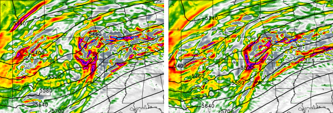
The reason for the change in the NAM is due to how it handles the wave as it ejects out into and through the Plains. The 18z run went with a slightly more amped and tilted wave. Subtle differences, but they matter greatly.
-
.
-
Differences with the HRRR (And RAP) can likely be attributed to how the HRRR (And RAP) handle things across the West. The main wave ejecting is more amped, and maybe slightly negative tilt while ejecting into the Plains… While at the same time, the main through and kicker wave is more neutral tilt. Most other guidance is neutral tilt with ejecting wave and positive tilt with kicker trough/wave. Goes to show that every little bit counts. (Hard to see image, but best I could do). .


