

Chicago Storm
-
Posts
18,587 -
Joined
-
Last visited
Content Type
Profiles
Blogs
Forums
American Weather
Media Demo
Store
Gallery
Everything posted by Chicago Storm
-
Makes sense. In this case trajectories are more towards the N/NE, instead of veering east with a squall line racing well east…That’s when we run into more of an issue. In this case the N/NE trajectory will cause an overlap of some convection making it into the cold sector, which is why we have that narrow axis of ‘higher’ snowfall accumulations being possible. Without it, deformation axis snows are lower end. .
-
0z NAM SE/weaker/drier. .
-
As did the GEM and Euro (Also bump SE). Something to watch for the Detroit crew and others in the main axis. .
-

Winter 2021-22 Short/Medium Range Discussion
Chicago Storm replied to Chicago Storm's topic in Lakes/Ohio Valley
Bump. Pattern change occurred as advertised early this week/this past weekend, with an active pattern this week and next week. As expected we are seeing a +AO/+NAO/-PNA, though the EPO will end up neutral/- overall instead of neutral/+. While the aforementioned EPO and the persistent PV based north of the Hudson will help keep this period from being an all out torch with significantly NW cutting storm systems, we obviously are/will see mild temp pushes (Current push, and one or two next week) and rainer risk for some. Looks like our next pattern change will occur at the very end of the month and as we enter early March. Early signs from ENS would suggest the potential for a +AO/+NAO/-EPO and neutral/+PNA pattern, which would suggest we would have the potential to flip back to a more consistently cooler/colder and potentially at least a somewhat less active pattern for bigger/organized storm systems. In addition to that, we are entering a period of SC on this side of the pole, so that would temp to support a cooler/colder idea as well during that time. We'll see how it trends, as ENS have continued to significantly struggle in the longer range this season. -
Some guidance continues to try to put down several inches tonight in N IL. But realistically, the chances of anything meaningful seem low as of now.
-
Euro for comparison. undefeated.
-
I give you the NCEP trash known as the GFS...
-
you need to work on your hits. .
-
-
12z GFs still coming back to reality with another bump SE. .
-
Even though snow depth has been 0 out this way (ORD and home), there’s a lot of standing water around from a combo of melting drifted areas/piles and the ground starting to defrost a bit. Likely will see some minor, but widespread flood issues later. .
-
12z NAM similar to 6z run. Noise level changes mostly. .
-
the dream team is back. .
-
0z GEM ENS mean .
-
-
That's mostly sleet on the RAP, which it is trying to show as 3-6" of snow.
-
0z GEM a slight bump NW and wetter.
-
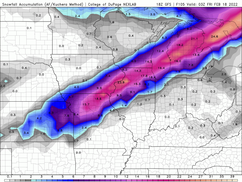
0z GFS bumping SE.
-
0z RGEM holds main axis, but did expand precip NW.
-
Frozen ground leading to runoff is one of the issues.
-
0z NAM looks similar to 18z run. .
-
are you really surprised though. .
-
18z EPS mean. Bump SE and weaker. .
-
Main wave is handled differently. It started off SE for western sub-forum, then corrects a bit NW for eastern sub-forum.
-
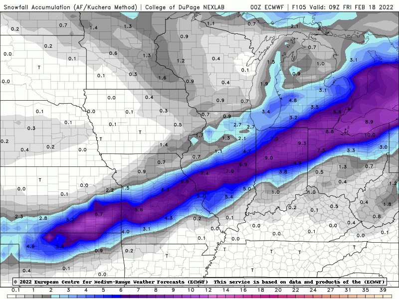
18z Euro going SE again.


