Chicago Storm
-
Posts
19,240 -
Joined
-
Last visited
Content Type
Profiles
Blogs
Forums
American Weather
Media Demo
Store
Gallery
Everything posted by Chicago Storm
-

Winter 2022/23 Medium/Long Range Discussion
Chicago Storm replied to Chicago Storm's topic in Lakes/Ohio Valley
Oh, and if you want bad... For the climate period of 1911-1930, the average seasonal snowfall for Chicago was was 29.7". (31.4" for standard 30 year climate period of 1901-1930). We live in an area that has a lot of variability is the point here. -
Winter 2022/23 Medium/Long Range Discussion
Chicago Storm replied to Chicago Storm's topic in Lakes/Ohio Valley
Only 38 of 139 Decembers have had 10.0" or more of total snowfall, and several (6) barely made it over that threshold. That's only 27% of Decembers since 1884. So yea, it's about time you accept where you live. -
Winter 2022/23 Medium/Long Range Discussion
Chicago Storm replied to Chicago Storm's topic in Lakes/Ohio Valley
Oh, I am tracking... There are some top 10 lists we will be cracking soon for snowfall futility. -
Winter 2022/23 Medium/Long Range Discussion
Chicago Storm replied to Chicago Storm's topic in Lakes/Ohio Valley
There have been 8 such, most recently 2017 with 0.6" of snow. -
Winter 2022/23 Medium/Long Range Discussion
Chicago Storm replied to Chicago Storm's topic in Lakes/Ohio Valley
the only think i want to slant stick is 89° days to 90°. -
Winter 2022/23 Medium/Long Range Discussion
Chicago Storm replied to Chicago Storm's topic in Lakes/Ohio Valley
ORD snowfall by "event" this season... Nov 15-19th: 1.1" Dec 9th: 0.2" Dec 15-16th: 1.7" Dec 22nd: 1.3" Jan 5th: 0.2" -
Winter 2022/23 Medium/Long Range Discussion
Chicago Storm replied to Chicago Storm's topic in Lakes/Ohio Valley
I wouldn't lock that in as a likelihood across the sub-forum on a consistent basis as of yet. -
Winter 2022/23 Medium/Long Range Discussion
Chicago Storm replied to Chicago Storm's topic in Lakes/Ohio Valley
Define “much colder”. . -
i concur.
-
lol, no to all of this.
-
you heard it here first. the only weekend of 2023 was also the first dry weekend of 2023.
-
Winter 2022/23 Medium/Long Range Discussion
Chicago Storm replied to Chicago Storm's topic in Lakes/Ohio Valley
don’t you wish you could change that? . -
Winter 2022/23 Medium/Long Range Discussion
Chicago Storm replied to Chicago Storm's topic in Lakes/Ohio Valley
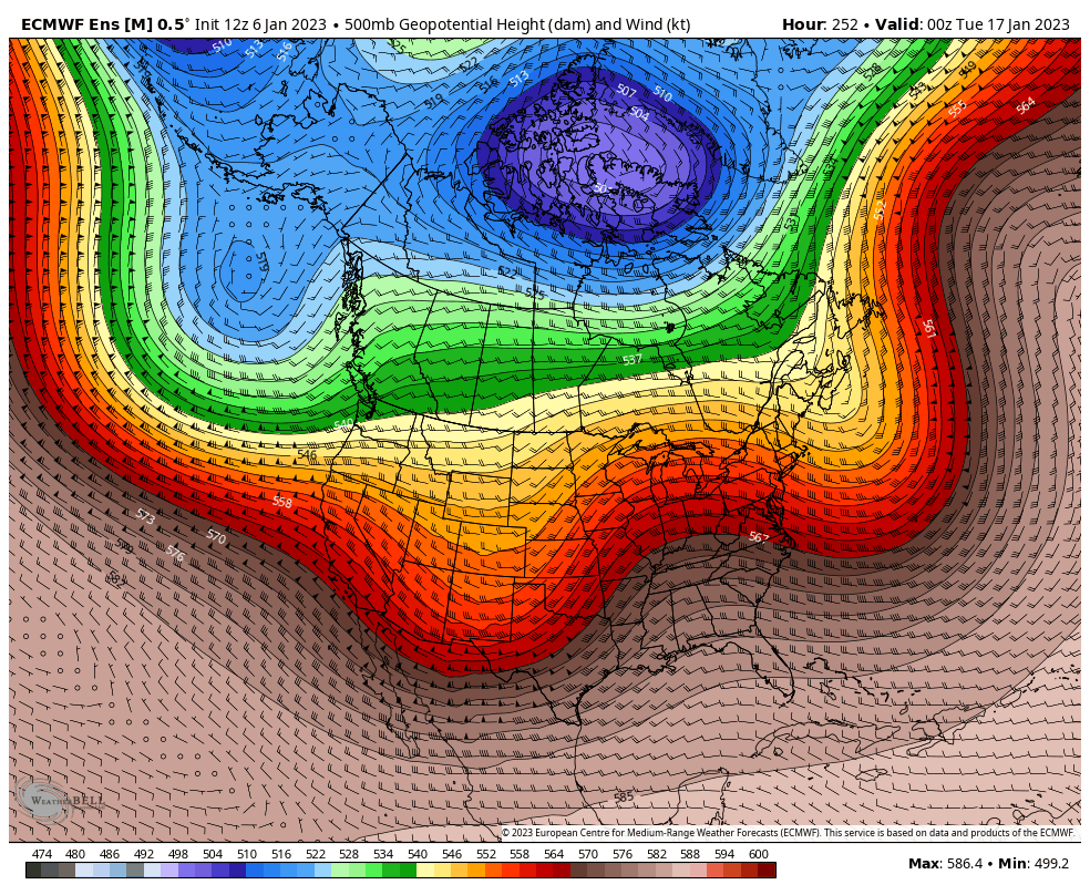
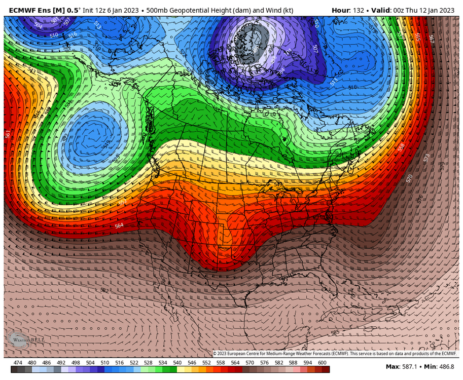
Really not much to say regarding the upcoming middle 1/3rd of January (11-20th)... For the most part, the pattern we are currently in is expected to continue for most of this upcoming period. While looking at the traditional teleconnections wouldn't give you the big picture of information, we are most definitely still in a +WPO/+EPO/N PNA/+NAO like pattern. As has been the case to end December and for the first 1/3rd of January, this will lead to a similar pattern continuing. A mix of cool/mild temperatures will continue, with AN being the overall case for much of the sub-forum. An active weather pattern across the CONUS will also continue, thanks to the +WPO/+EPO/N PNA combo. If we were to have paired a -PNA with the +WPO/+EPO combo, we could have reallyyy torched and could have seen even more severe t'storm opportunities, so that's a small bright spot for the winter lovers in that hasn't/isn't occurring. However, with the main cold air locked in around Asia/North Pole/Northern Canada, this means any snow chances will be continued best across the northern portions of the sub-forum, with elsewhere struggling to see a minor event potential...unless a super thread the needle event can pop up. Beyond the upcoming middle of January period and looking towards the final 1/3rd late January period, there are once again some long off hints of maybe some change, but that is still a while off. Recall though, at the end of December there were once long off hints that there could be change during this mid-month period, that obviously will not occur.
-
there's been better.
-
Winter 2022/23 Short/Medium Range Discussion
Chicago Storm replied to Chicago Storm's topic in Lakes/Ohio Valley
looks like a usual saturday and sunday. -
0.2” of snow at ORD with the wrap around -SN/snow showers overnight and this morning. .
-
ah, i see we’ve reached that point on the forum haven’t we. just think, 55 days until met spring arrives. .
-
Winter 2022/23 Medium/Long Range Discussion
Chicago Storm replied to Chicago Storm's topic in Lakes/Ohio Valley
i'm just going to put this right here for you...
-
We've had visibility as low as 1/16SM this evening with the FG here at ORD.
-
Winter 2022/23 Medium/Long Range Discussion
Chicago Storm replied to Chicago Storm's topic in Lakes/Ohio Valley
i make no promises. -
2023 Short/Medium Range Severe Weather Discussion
Chicago Storm replied to Chicago Storm's topic in Lakes/Ohio Valley
Added a few since that time, including one in Decatur quite possibly. -
Winter 2022/23 Medium/Long Range Discussion
Chicago Storm replied to Chicago Storm's topic in Lakes/Ohio Valley
Will have more info in the usual post in a few days, but current mid-month (11-20th) outlook: Move along. -
Went from the TS and hail earlier, to 1/8SM FG at ORD now.
-
2023 Short/Medium Range Severe Weather Discussion
Chicago Storm replied to Chicago Storm's topic in Lakes/Ohio Valley
It appears there were 5 brief tornadoes in total. Very brief event too, impacting only a very small portion of the state. -
Had a brief bout of 0.25" hail here as well with the TS.