Chicago Storm
-
Posts
18,587 -
Joined
-
Last visited
Content Type
Profiles
Blogs
Forums
American Weather
Media Demo
Store
Gallery
Everything posted by Chicago Storm
-
accurate is an understatement here.
-

Summer 2022 Medium/Long Range Discussion
Chicago Storm replied to Chicago Storm's topic in Lakes/Ohio Valley
Time for an update, though there's really not much to update... Things have gone fairly close to expectations over the past few weeks, since the above update in late June. Looking forward, the next few weeks through the end of the month don't look too significantly different from the pattern we are in/have been in. There will continue to be persistent troughing in the vicinity of the GOA on down into the PAC NW...Which is a continuation of what has been occurring the past few weeks. It does appear the persistent ridging that has been seen the past few weeks in W and/or C Canada will tone down, so that is one change. Persistent troughing will also continue across the Hudson/Greenland/Great Lakes/Northeast regions as well, with a bit of ridging at times popping up around part of Greenland/Arctic regions...All of which is also a continuation of what has been occurring the past few weeks as well. All in all, this will continue to lead to a lot of what we have been seeing already this month... The main ridge/heat dome will continue to be centered across the Inter-Mountain West/Central and Southern Plains, and possibly into the Southeast at times. This will continue to keep most of this sub-forum in a more northwestly flow pattern, with an average to active weather pattern. This also means the most consistently hot temperatures will continue to be limited to the far southwestern portions of the sub-forum, with hotter conditions elsewhere being short lived ahead of passing storm systems.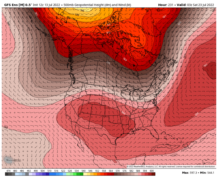
- 143 replies
-
- 10
-

-

-
Summer 2022 Medium/Long Range Discussion
Chicago Storm replied to Chicago Storm's topic in Lakes/Ohio Valley
under. definitely going to have mixing concerns. -
should mean we get another 3 or 4 posts today.
-
That's a large wind farm.
-
We're probably just about done for the day/night regarding anything interesting/meaningful.
-
Summer 2022 Medium/Long Range Discussion
Chicago Storm replied to Chicago Storm's topic in Lakes/Ohio Valley
we get it. -
2022 Short/Medium Range Severe Weather Discussion
Chicago Storm replied to Chicago Storm's topic in Lakes/Ohio Valley
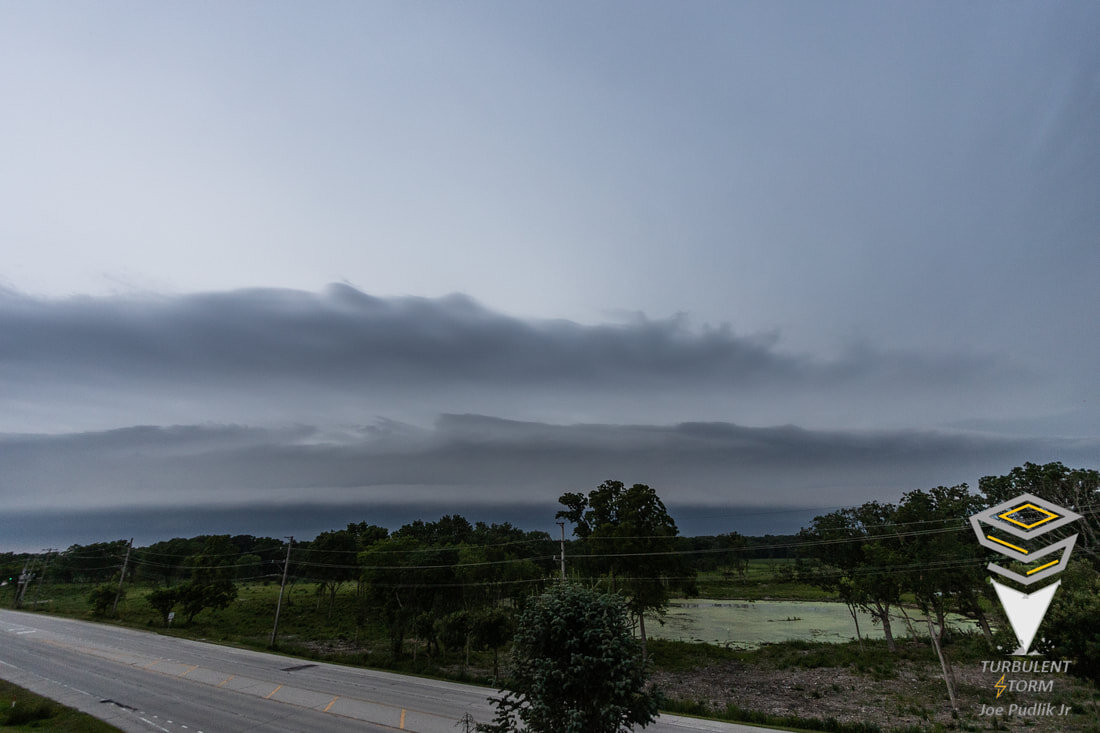
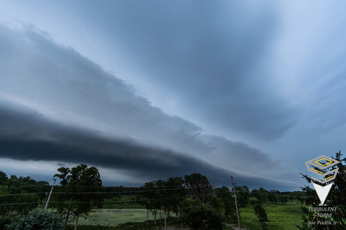
Forgot to post these shots from home Tuesday evening, of a shelf cloud along an OFB pushing out ahead of a severe t'storm to the northwest.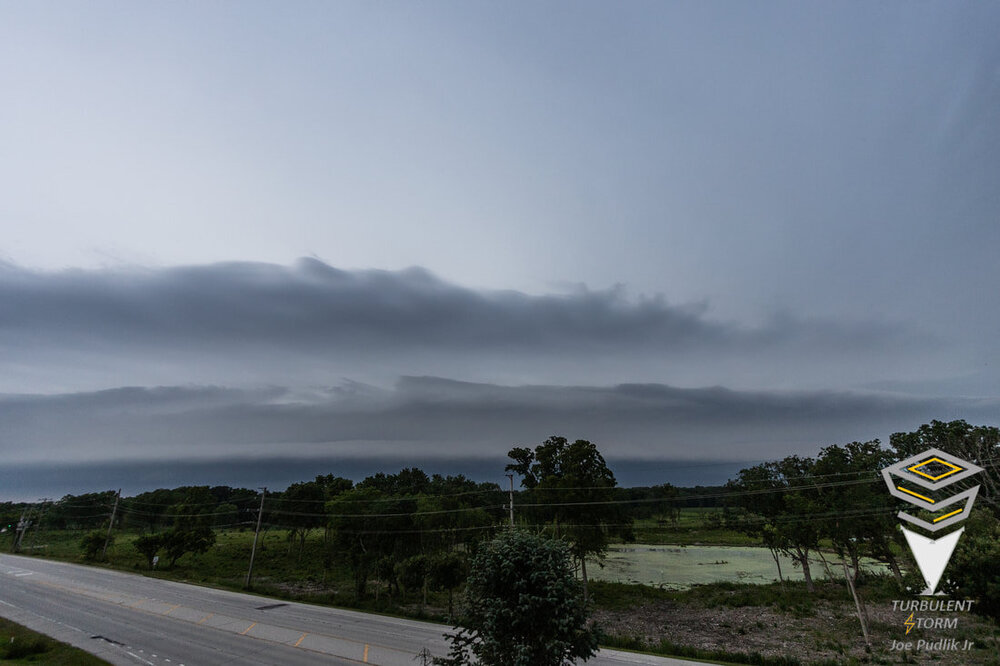

-
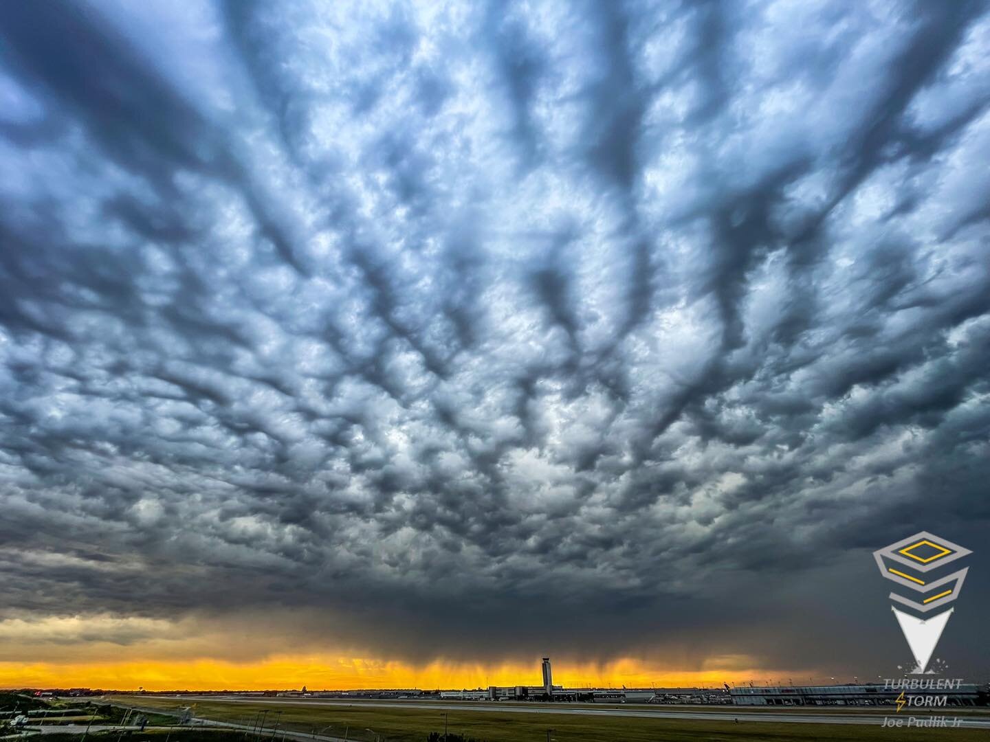
Nice scenes a bit ago, as some shower/t’storm activity attempted to move in with 30° T/DP spreads.

-
finally has reached the point of bothering you, eh. took long enough.
-
Spring/Summer 2022 Complaint/Banter Hangout
Chicago Storm replied to IWXwx's topic in Lakes/Ohio Valley
Yea, the OP Euro/GEM and the EPS are all a long ways off from the OP GFS solution. Kind of why I started the mention in here, instead of another thread. The GEFS have made a steady flip towards more of what the OP GFS is showing though. -
Spring/Summer 2022 Complaint/Banter Hangout
Chicago Storm replied to IWXwx's topic in Lakes/Ohio Valley
There definitely has been improvement, especially across portions of IA/S WI/IL/IN/OH. -
Spring/Summer 2022 Complaint/Banter Hangout
Chicago Storm replied to IWXwx's topic in Lakes/Ohio Valley
No, you’re right. 12z was much more impressive. -
Spring/Summer 2022 Complaint/Banter Hangout
Chicago Storm replied to IWXwx's topic in Lakes/Ohio Valley
12z OP GFS took it to the next level. -
an mcs (with some severe risk) is the same as a fall storm these days, eh.
-
Spring/Summer 2022 Complaint/Banter Hangout
Chicago Storm replied to IWXwx's topic in Lakes/Ohio Valley
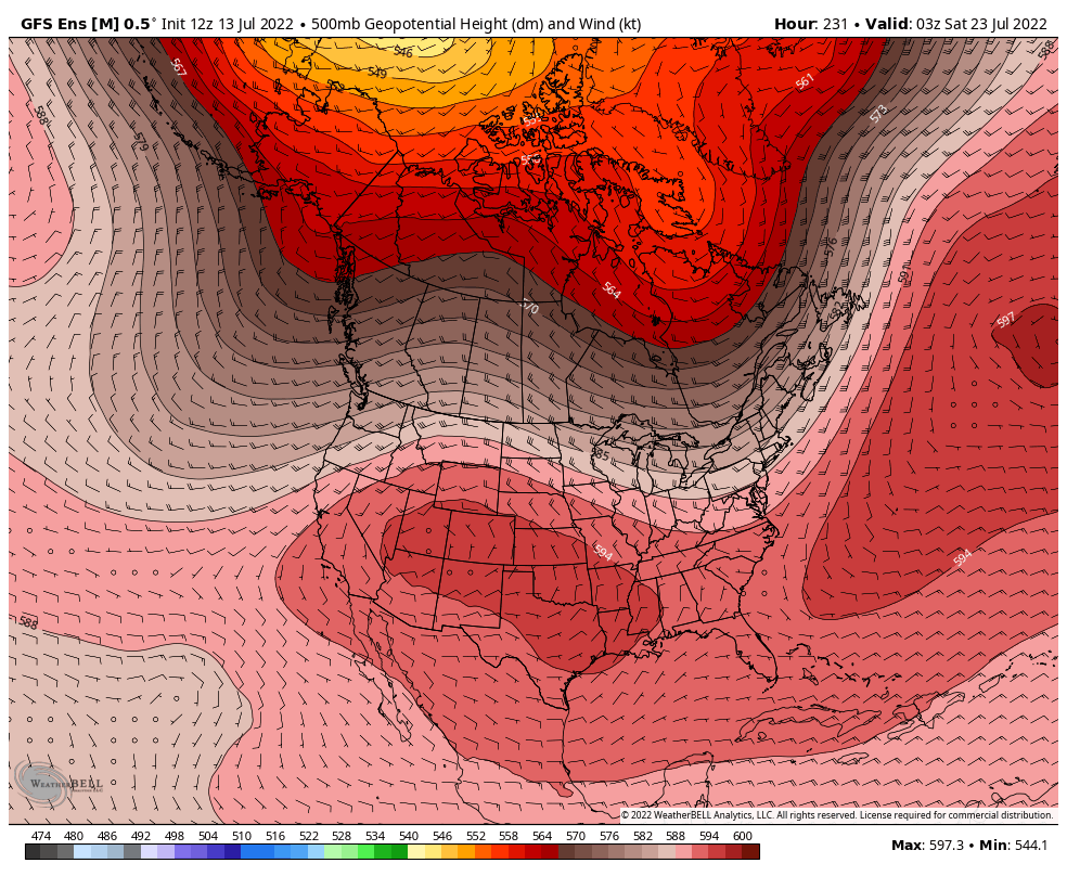
600DM ridge centered near STL. It's what dreams are made of. -
Time to put this to bed... ...GRR... July (So far): +0.21" June: -2.52" May: +0.07" April: +1.20" March: +1.11"
-
Spring/Summer 2022 Complaint/Banter Hangout
Chicago Storm replied to IWXwx's topic in Lakes/Ohio Valley
@Hoosier is going to hold on to the 18z OP GFS run, and never let go. -
Final high temps for today across the area... 95 MDW 94 ORD 95 RFD 97 Ex-Home Also should mention that MDW somehow hit 90 yesterday. 90°+ day tally for the year... 17 - MDW16 - RFD14 - Ex-Home12 - Current Home10 - ORD
-
2022 Short/Medium Range Severe Weather Discussion
Chicago Storm replied to Chicago Storm's topic in Lakes/Ohio Valley
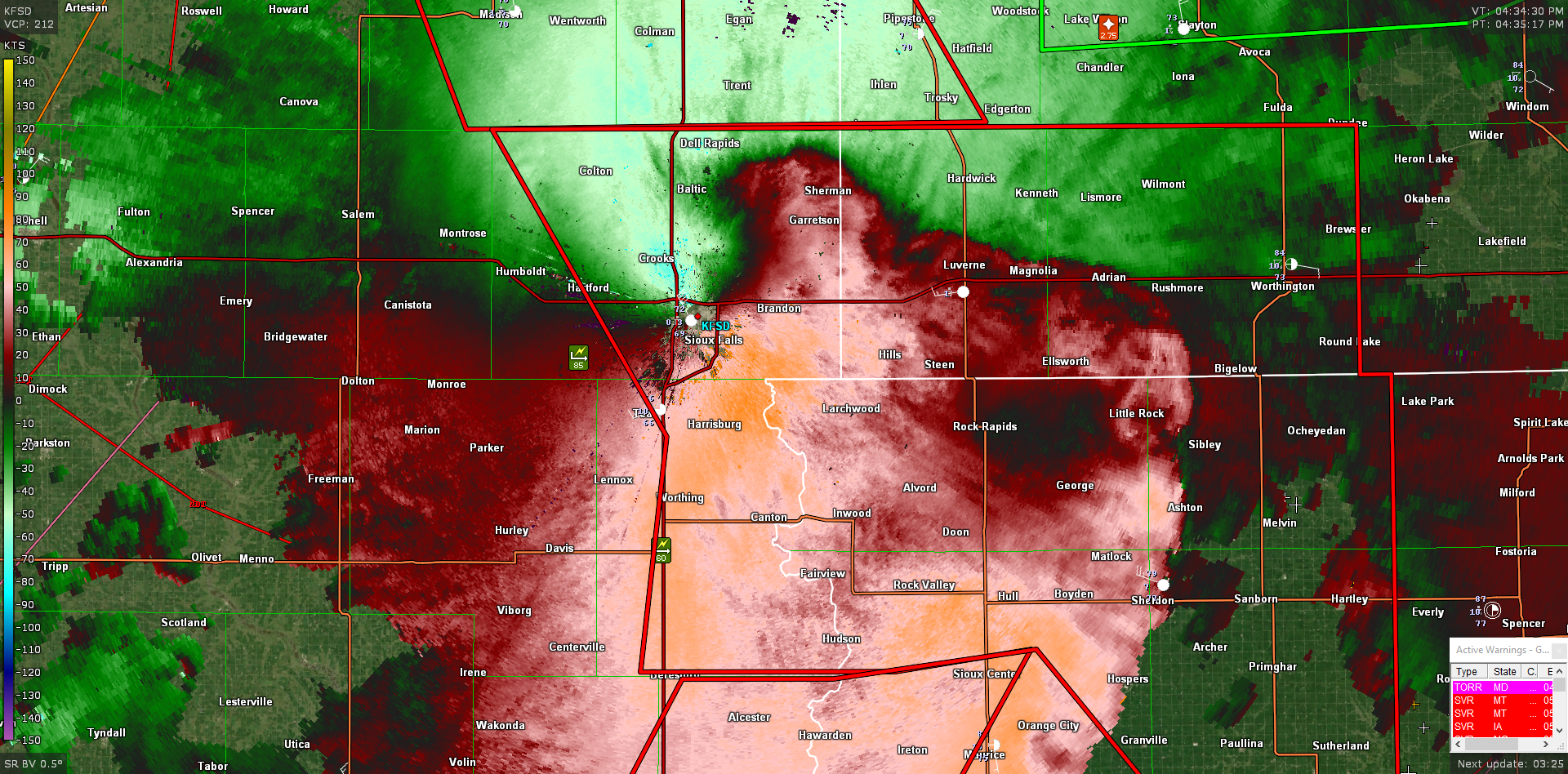
Not our sub-forum, but Sioux Falls is currently getting the 2022 version of the Cedar Rapids 2020 derecho RIJ...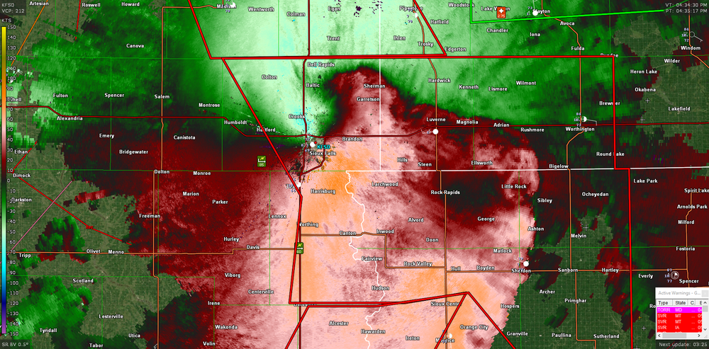
-
The criteria for an EHW outside of Cook Co is two days of heat indices of 110+.
-
2022 Short/Medium Range Severe Weather Discussion
Chicago Storm replied to Chicago Storm's topic in Lakes/Ohio Valley
This is why BAM is and always has been terrible. -
2022 Short/Medium Range Severe Weather Discussion
Chicago Storm replied to Chicago Storm's topic in Lakes/Ohio Valley
Hopefully the SPC upgrades portions of SD/MN/NE/IA to a moderate risk. Looks like a textbook long-track MCS/derecho setup. An MCS currently in SD, which originated in far W MT yesterday evening, has matured and is tied to a nice wave topping the ridge over the Central US. Should see that complex ride the instability gradient ESE through the afternoon/evening, acorss portions of SD/NE/MN/IA. How far east it makes it will be dependent on other developing convection through the day ahead of it, near a frontal boundary in place. -
2022 Short/Medium Range Severe Weather Discussion
Chicago Storm replied to Chicago Storm's topic in Lakes/Ohio Valley
As the MCS moved through, had peak wind gusts of 55MPH ORD, 51MPH MDW and 50-60MPH here at home. -
It handled during the day better than the NAM, but still not the best. It has nothing tonight.