Chicago Storm
-
Posts
18,660 -
Joined
-
Last visited
Content Type
Profiles
Blogs
Forums
American Weather
Media Demo
Store
Gallery
Everything posted by Chicago Storm
-
That depends on your definition of warm.
-
And now 101° today.
-
Paducah hit 100° today. .
-
I couldn't believe it while watching it, especially with a solid high cloud deck.
-
Some of the 90°+ high temps from across the area today... 94 MDW 93 Home 90 RFD90°+ day tally for the year...28 - MDW20 - RFD19 - Ex-Home17 - Current Home16 - ORD
-

2022 Short/Medium Range Severe Weather Discussion
Chicago Storm replied to Chicago Storm's topic in Lakes/Ohio Valley
Not only CAMS, but most other guidance also didn't have much of anything for the most part. -
2022 Short/Medium Range Severe Weather Discussion
Chicago Storm replied to Chicago Storm's topic in Lakes/Ohio Valley
A severe t’storm headed towards here at ORD faded as it approached, but it still provided great garden variety action. Looks like home may have faired a bit better, with a more sustained line of severe warned t’storms having hit there a bit ago. -
Yea, the boundary washed out rapidly, and at the same time cirrus from severe activity north moved in...but it didn't stop the rise. MDW made it well over 90, and ORD fell well short.
-
2022 Short/Medium Range Severe Weather Discussion
Chicago Storm replied to Chicago Storm's topic in Lakes/Ohio Valley
Severe warned supercell t'storm up around RFD has a broad/weak couplet. -
It's 99 in Muscatine currently.
-
Unless there's a late rally if the lake enhanced OFB that's currently across the metro washes out, today's likely last shot at 90+ for the year will fall short at both ORD and MDW.
-
2022 Short/Medium Range Severe Weather Discussion
Chicago Storm replied to Chicago Storm's topic in Lakes/Ohio Valley
Had a severe t'storm pass just north of here at home a few hours ago, which produced some hail along it's path of travel. Ended up with a fairly good light show with it here, especially for nearing late September. -
2022 Short/Medium Range Severe Weather Discussion
Chicago Storm replied to Chicago Storm's topic in Lakes/Ohio Valley
Today/tonight looks moderate risk-ish across SE IA/NE MO/W IL. -
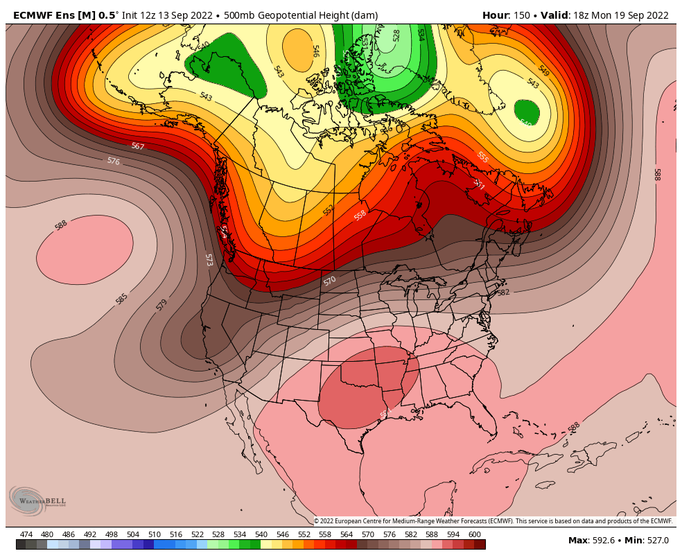
It's been a while since I've had a chance to throw out any thoughts regarding the medium/long range, but really there hasn't been anything that has significantly changed since my last post in the summer thread from mid-August. The pattern we have seen dominant much of the summer was expected to continue through the end of August, and it ended up doing so. For the first half of September, a variation of this same pattern has continued...Though with a bit more troughing along the West Coast at times and a few transient bouts of ridging up in the Greenland/North Pole area at times. We are finally going to see a significant change coming up shortly, but it appears as though it will be short lived. As is being mentioned by many, we are looking at a warm up for late this week through the first half of next week across a good chunk of the sub-forum. This warm up will bring a re-introduction to temperatures into the 80's/90's for many for a several day period. This warm up will be a product of an increasing -PNA/West Coast trough, one of the most significant we have seen all summer. This will pump up ridging across the Central/Southern Plain, Ohio Valley and Southeast...Leading the the aforementioned period of warmer/hotter temps. Beyond this time (After mid-next week), like clock work it appears we'll head back into some variation of the dominant pattern we've seen much of the summer.

-
mid-march is 6 months away.
-
There were numerous couplets with non-severe t’storms/rain showers across NE IL and Southern Lake Michigan today. Some of this activity, as alluded to by madwx, did spin up into an MCV or two.
-
SLP fairly visible on radar the past few hours, moving north over Lake Michigan. The mild lake and frictional land/water differences on either side may be having a positive feedback on things a bit. .
-
Yea, that more significant couplet had to have produced.
-
Not surprising, but MDW was the only site to tag 90°+ in NE IL. 90°+ day tally for the year... 27 - MDW 19 - RFD 19 - Ex-Home 16 - ORD 16 - Current Home
-
Ironically, that summer lead into a 3rd consecutive fall La Niña…which is also the case this year.
-
Even taking into account how MDW can be, I'd imagine it hasn't happened too much.
-
MDW was the only location to tag 90 in NE IL today. 90°+ day tally for the year... 26 - MDW19 - RFD19 - Ex-Home16 - ORD16 - Current Home
-
Spring/Summer 2022 Complaint/Banter Hangout
Chicago Storm replied to IWXwx's topic in Lakes/Ohio Valley
that’s two. need 6 more at the minimum. -
It worked out this month, but I'm not touching that for Sept. As you mentioned, there's a few opportunities coming up... Thur-Sat is the first window of opportunity, and then again *possibly* later next week/following weekend for the next window. That second period is far less certain, with tropical/cut-off ULL potential somewhere.
-
Spring/Summer 2022 Complaint/Banter Hangout
Chicago Storm replied to IWXwx's topic in Lakes/Ohio Valley
bump.