Chicago Storm
-
Posts
18,586 -
Joined
-
Last visited
Content Type
Profiles
Blogs
Forums
American Weather
Media Demo
Store
Gallery
Everything posted by Chicago Storm
-
Cedar Rapids reports all between 7-9"... Hawkeye rejoice.
-
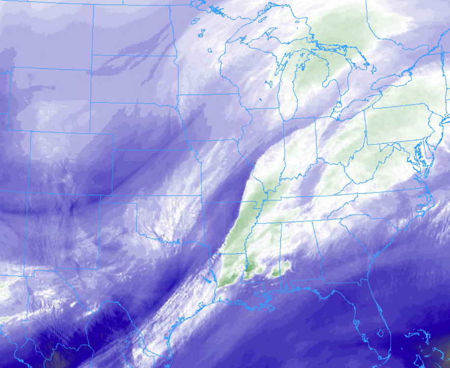
This second round of forcing is moving through fairly quickly, but there is some nice banding. Currently +SN 1/4SM here at ORD.
-
Event total of 1.5" here at ORD thus far.
-

2/14-2/15 Potential Major Winter Storm
Chicago Storm replied to A-L-E-K's topic in Lakes/Ohio Valley
The issue is more-so aloft. Checking it out under the hood at 500mb tells the story, in which we are dealing with a strung out wave. As mentioned earlier, that is a good thing in this case. A fully consolidated and potent wave, which phases, would likely mean a rainer for most. -
It's pouring tiny flakes here at ORD.
-
2/14-2/15 Potential Major Winter Storm
Chicago Storm replied to A-L-E-K's topic in Lakes/Ohio Valley
wonder how our friend has been. -
2/14-2/15 Potential Major Winter Storm
Chicago Storm replied to A-L-E-K's topic in Lakes/Ohio Valley
see, this is quality discussion now. -
2/14-2/15 Potential Major Winter Storm
Chicago Storm replied to A-L-E-K's topic in Lakes/Ohio Valley
i'm aware, dan-o boy. -
2/14-2/15 Potential Major Winter Storm
Chicago Storm replied to A-L-E-K's topic in Lakes/Ohio Valley
way too much NAM talk in this thread. -
Quick look at WV imagery shows the next round will be getting going shortly, as better forcing and the main jet streak translate through.
-
Kind of a badly worded graphic there by LOT. That is neither a dry slot nor dry air. There is a gap between better forcing. We've seen the first round of better forcing translate through over the past few hours, and we'll have another round later.
-
2/14-2/15 Potential Major Winter Storm
Chicago Storm replied to A-L-E-K's topic in Lakes/Ohio Valley
It’s down until further notice. Big tech issues. -
2/14-2/15 Potential Major Winter Storm
Chicago Storm replied to A-L-E-K's topic in Lakes/Ohio Valley
with this one, you don’t want too many improvements at h5, otherwise it turns into a mostly rainer for most. strung out will be beneficial. you could overlap with a several inch lead thump, followed up by a several inch main hit. -
2/14-2/15 Potential Major Winter Storm
Chicago Storm replied to A-L-E-K's topic in Lakes/Ohio Valley
half of the time i just type and don’t even look before hitting send. so, who knows what I actually put to switch to that. -
2/14-2/15 Potential Major Winter Storm
Chicago Storm replied to A-L-E-K's topic in Lakes/Ohio Valley
autocorrect killed that one. it IS an inspiring look. some very obvious similarities to the current setup, but also some glaring differences as well. -
i'm always lurking in the shadows.
-
what busted?
-
2/14-2/15 Potential Major Winter Storm
Chicago Storm replied to A-L-E-K's topic in Lakes/Ohio Valley
this is not an inspiring look.
-
it's a shame that this large-scale set-up is gonna go to waste. all of the pieces were in place, but smaller scale alignment of one or two things will be preventing the goods.
-
thought you were ok with 3"?
-
Last 6”+ event: Jan 12-13th, 2024. (6.7”) Last 8”+ event: Jan 30-31st, 2021. (10.8”)
-
i thought it dusted out?
-
definitely not. at least not yet…
-
A glaze of ice accumulation and 0.1” of snowfall accumulation at ORD yesterday. That 0.1” of snow was enough to push the seasonal snowfall total up to 10.0”.
-
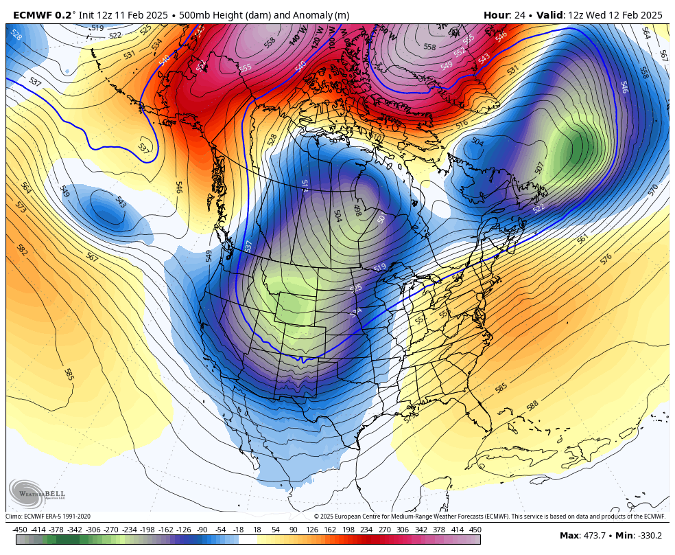
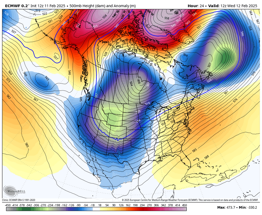
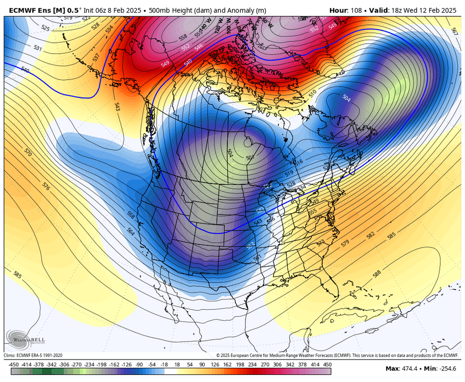
This is a top of the line look overall, with a lot of boxes checked. There's a lot going on here, which is why I mentioned in the medium/long range thread that this is one of the most complex large scale patterns that we've seen in quite a while. The typical Hudson TPV is displaced to the southwest, with a consistent 50/50 low around the Labrador Sea. We have not seen this placement of the TPV much over the past several years. Notice all of the significant ridging up near the pole, which is a product of a split of the SPV. It's not always that we see SPV effects translate immediately, but in this case we are. Also notice the positive height anomalies present in the East/Southeast, a product of a Southeast ridge. This is representative of the MJO, which has been translating through high correlation warm/East ridge favored phases. Heading into this pattern, we once again had a -EPO/Alaska ridge, which once again helped to re-charge Canada cross polar flow cold.
- 605 replies
-
- 12
-

-

-