Chicago Storm
-
Posts
18,587 -
Joined
-
Last visited
Content Type
Profiles
Blogs
Forums
American Weather
Media Demo
Store
Gallery
Everything posted by Chicago Storm
-

Spring/Summer 2022 Complaint/Banter Hangout
Chicago Storm replied to IWXwx's topic in Lakes/Ohio Valley
better get used to the zzz, because it's going to be around for a while. -
you’re missing the point.
-
it’s no different than when we start talking about the sun angle when we start to roll into february.
-
Summer 2022 Medium/Long Range Discussion
Chicago Storm replied to Chicago Storm's topic in Lakes/Ohio Valley
With the way the pattern is looking through the beginning portion of the end of the month, it definitely isn't going to be any time soon at the least. -
Summer 2022 Medium/Long Range Discussion
Chicago Storm replied to Chicago Storm's topic in Lakes/Ohio Valley
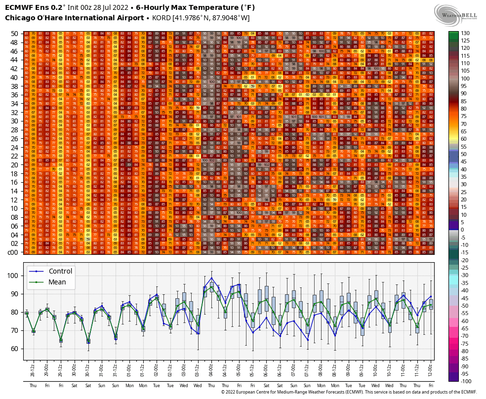
Not to go all Spartman, but the high of 95 at ORD/MDW this past Saturday was 'probably' the last 90+ day this month for Chicago. -
you're in atlanta now?
-
Catching up a bit... Some high temps from this past Sat (Aug 6th) across the area... 95 MDW 95 ORD 94 RFD 94 Ex-Home It also hit 90 at RFD this past Fri (Aug 5th). 90°+ day tally for the year... 24 - MDW19 - RFD19 - Ex-Home16 - ORD16 - Current Home
-
Some high temps from today across the area... 95 MDW 92 ORD 90 Ex-Home 90°+ day tally for the year... 23 - MDW17 - RFD18 - Ex-Home15 - ORD14 - Current Home
-
Summer 2022 Medium/Long Range Discussion
Chicago Storm replied to Chicago Storm's topic in Lakes/Ohio Valley
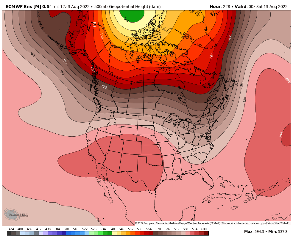
It's been a while since the last full update, though I've mentioned some tidbits here at there regarding the first part of August and not being onboard with the heat train. The previous full update above worked out pretty close to what was expected. However, for the very tail end of July (Final full week and weekend) we actually flipped briefly to a different pattern. That pattern continued to feature the well established/persistent/significant troughing across the Hudson/Greenland/Great Lakes/Northeast region, but the troughing that had been persistent across the GOA/PAC NW was replaced by ridging. This allowed for a cooler and drier week for much of the sub-forum (Minus far southern areas with the heavy rain/flooding that occurred). This week to start August we have reverted back to the previous pattern, which has been around much of the summer. As mentioned numerous times over the past few months, this pattern features well established and persistent/significant troughing in the Hudson/Greenland/Great Lakes/Northeast region, as well as persistent (But less significant) troughing in the GOA/PAC NW region. The main ridging continues to be sandwiched between, across the Inter-Mountain West/Plains and extending into the Southeast at times. All in all, this will lead to similar conditions as to what we have seen much of this summer for both early and middle August. The one exception appears to be around this upcoming weekend (Aug 6-7th ish). There will be another flex of the main ridge, as both areas of aforementioned persistent troughing briefly relax, allowing for ridging to briefly poke into much more of the sub-forum, along with a brief push of hotter conditions. Outside of that, the same summer pattern we have seen will generally continue.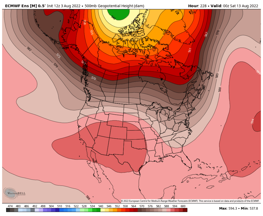
-
2022 Short/Medium Range Severe Weather Discussion
Chicago Storm replied to Chicago Storm's topic in Lakes/Ohio Valley
Make sense given the action down that way. I haven't had a chance to look at the OBS out of there in a while. -
2022 Short/Medium Range Severe Weather Discussion
Chicago Storm replied to Chicago Storm's topic in Lakes/Ohio Valley
Peak wind gust here at ORD today has been 38MPH, but not associated with any t’storm activity…just synoptic. -
2022 Short/Medium Range Severe Weather Discussion
Chicago Storm replied to Chicago Storm's topic in Lakes/Ohio Valley
A downburst frenzy with the severe t’storm activity in parts of the metro, as almost every t’storm has had downburst signature at some point. -
Spring/Summer 2022 Complaint/Banter Hangout
Chicago Storm replied to IWXwx's topic in Lakes/Ohio Valley
We really haven’t had a real -NAO, just a pseudo weak one from time to time. It has been more-so the persistent and significant troughing across the Hudson/Greenland/Great Lakes/Northeast much of the summer, as well a fairly persistent troughing across the GOA/Pac NW. -
someone got fooled by the fake GFS mixing/thermals.
-
Some high temps from today across the area... 91 MDW 90 ORD 91 Ex-Home 90°+ day tally for the year... 22 - MDW17 - RFD17 - Ex-Home14 - ORD13 - Current Home
-
Over 10” radar estimates now…
-
2022 Short/Medium Range Severe Weather Discussion
Chicago Storm replied to Chicago Storm's topic in Lakes/Ohio Valley
heat isn’t looking great (not surprisingly), so moving attention to severe? -
Summer 2022 Medium/Long Range Discussion
Chicago Storm replied to Chicago Storm's topic in Lakes/Ohio Valley
This upcoming period still does not impress this heat monger in terms of max heat potential. It appears the consistent troughing across Hudson/Greenland/Great Lakes/Northeast will send frequent frontal intrusions through portions of the sub-forum, making for more of a roller coaster temperatures setup between warm and hot conditions. It definitely does not look at all like a prolonged heat wave for at least half of the sub-forum at this point due to the above. The QC area on down to the STL area and into the OV is definitely in a better position for more prolonged heat wave than anywhere else in the sub-forum. -
Summer 2022 Medium/Long Range Discussion
Chicago Storm replied to Chicago Storm's topic in Lakes/Ohio Valley
The EPS sum up how this upcoming period will likely go.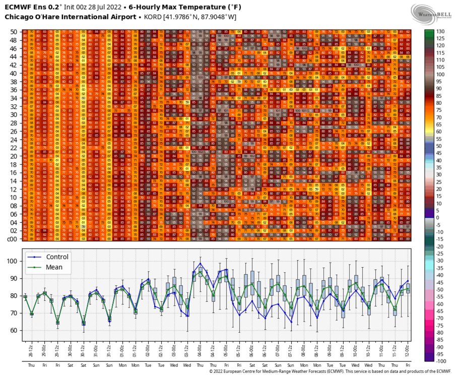
-
Summer 2022 Medium/Long Range Discussion
Chicago Storm replied to Chicago Storm's topic in Lakes/Ohio Valley
I’m still not sure what NCEP did to it, but whatever it is, it needs to be reversed. -
Summer 2022 Medium/Long Range Discussion
Chicago Storm replied to Chicago Storm's topic in Lakes/Ohio Valley
Expectations for that early August potential should probably be tempered for now, until we actually see the what strength of both the GOA/PAC and Hudson/Greendland troughing looks like as we get a it closer. -
Crazy stuff around the STL area overnight and into this morning.
-
Summer 2022 Medium/Long Range Discussion
Chicago Storm replied to Chicago Storm's topic in Lakes/Ohio Valley
I haven’t been able to find any information on if there had been any sort of upgrade conducted to the OP GFS heading into the summer. In any case, between it being too amped with ridging in the extended and the unrealistic super deep mixing it consistently has, it’s toss worthy on the reg now. -
Spring/Summer 2022 Complaint/Banter Hangout
Chicago Storm replied to IWXwx's topic in Lakes/Ohio Valley
that's the spirit. -
Spring/Summer 2022 Complaint/Banter Hangout
Chicago Storm replied to IWXwx's topic in Lakes/Ohio Valley
GRR area rolled by multiple MCS’s last night, and frostfern is nowhere to be found.