Chicago Storm
-
Posts
18,587 -
Joined
-
Last visited
Content Type
Profiles
Blogs
Forums
American Weather
Media Demo
Store
Gallery
Everything posted by Chicago Storm
-
Had a few heavier snow showers while both at home and at ex home today, some of which were enough to dust all non-paved surfaces with a tenth or two of snowfall accumulation. .
-

Winter 2022/23 Short/Medium Range Discussion
Chicago Storm replied to Chicago Storm's topic in Lakes/Ohio Valley
Two issues with that… Most guidance did show snow that far north, and most guidance did show the potential for more snow than offices down there were forecasting, was was ranging from no snow up to 0.5”. On the flip side…There was very little support among guidance for anything really over 3” or so. So nonetheless, that band of 4-8” is still a surprise in the end. There was actually an event like this, which I believe may have been last winter, down in East-Central Illinois. It also occurred overnight/early morning, and dropped a localized/unexpected area of 6”+ snow. -
Winter 2022/23 Short/Medium Range Discussion
Chicago Storm replied to Chicago Storm's topic in Lakes/Ohio Valley
And to follow up on the follow up... Below is the list of all years on record in Chicago to feature a November with 4.0"+ total snowfall. As you can see, the following December is usually split potential for above/below normal snowfall, and usually seasonal total snowfall ends up above average. 1891: 6.8"......5.5"......26.8" 1893: 7.5"......12.1".....48.2" 1895: 14.5".....3.4"......52.5" 1896: 4.2"......1.3"......41.2" 1927: 14.9".....10.0".....29.3" 1940: 14.8".....4.1"......49.0" 1941: 5.2"......1.7"......40.5" 1947: 6.2"......6.4"......40.6" 1950: 7.0"......27.1".....60.0" 1951: 14.3".....33.3".....68.3" 1953: 7.6"......5.4"......28.4" 1954: 5.7"......8.2"......44.2" 1955: 5.9"......2.1"......26.2" 1959: 6.6"......10.4".....44.1" 1972: 5.5"......10.3".....66.9" 1974: 5.1"......16.3".....53.7" 1975: 10.8".....11.7".....53.3" 1977: 6.3"......19.2".....64.3" 1978: 7.1"......31.4".....95.3" 1980: 5.1"......9.7"......48.8" 2002: 4.7"......8.0"......42.2" 2004: 5.1"......0.6"......29.0" 2015: 11.2".....4.5"......63.5" 2018: 12.7".....1.4"......44.8" -
Winter 2022/23 Short/Medium Range Discussion
Chicago Storm replied to Chicago Storm's topic in Lakes/Ohio Valley
To follow up on this... November snowfall totals in Chicago the past 20 years. As you can see, it has generally been all or nothing, with only a few in between. 2002: 4.7" 2003: T 2004: 5.1" 2005: 1.9" 2006: 0.4" 2007: 0.3" 2008: 0.6" 2009: T 2010: T 2011: T 2012: T 2013: 0.9" 2014: 2.8" 2015: 11.2" 2016: T 2017: 0.1" 2018: 12.7" 2019: 3.7" 2020: 0.7" 2021: T -
Winter 2022/23 Short/Medium Range Discussion
Chicago Storm replied to Chicago Storm's topic in Lakes/Ohio Valley
A normal November has snowfall opportunities. We're just not used to it. -
Winter 2022/23 Short/Medium Range Discussion
Chicago Storm replied to Chicago Storm's topic in Lakes/Ohio Valley
Watch next week. Not a slam dunk given several moving pieces, but potential is there. Best looking November pattern for widespread cold and some snow potential across such a large portion of the sub-froum, since Nov 2019. -
the deed has been done.
-
As usual, for the non-thread worthy events.
-
Record broken here at ORD. Peak of 76 so far.
-
Every November day needs to be like today. .
-
An fyi... The GFS is set to be upgraded on Nov 29th.
-
Fall 2022 Medium/Long Range Discussion
Chicago Storm replied to Chicago Storm's topic in Lakes/Ohio Valley
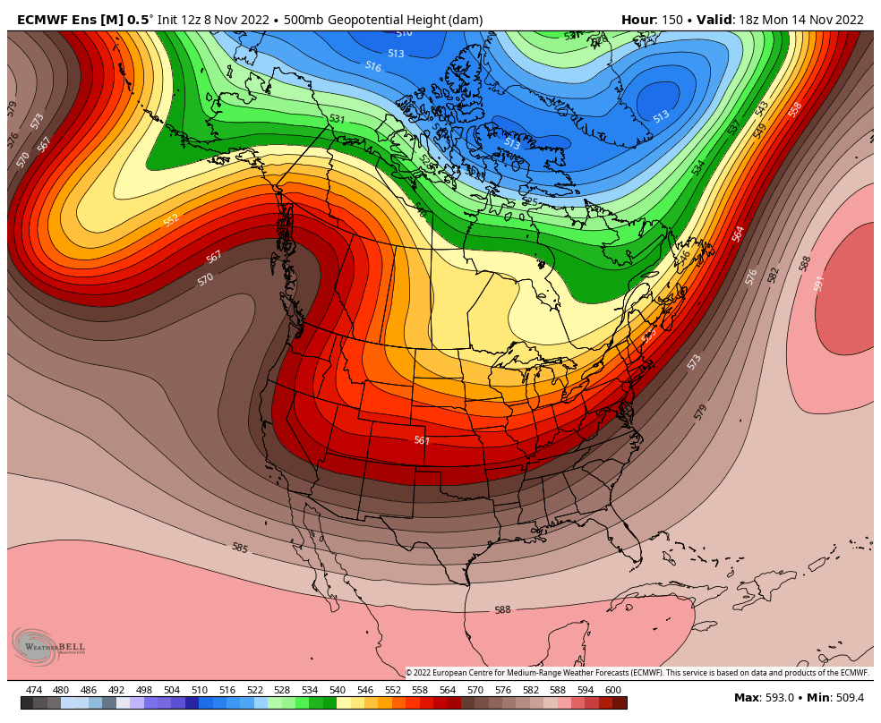
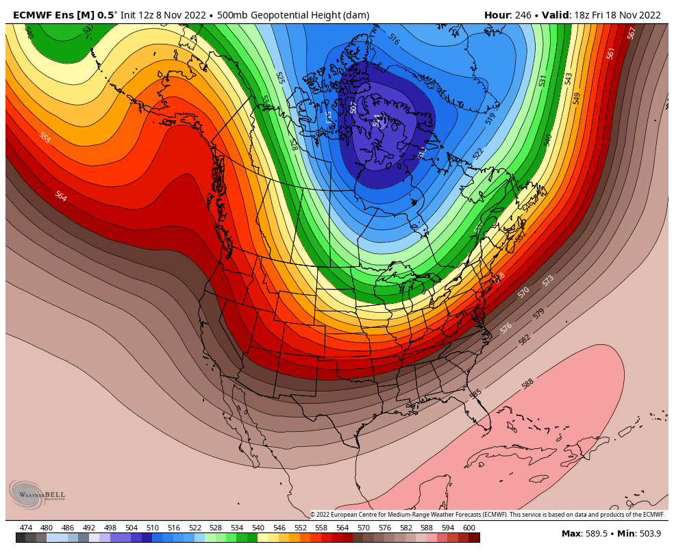
That later time has come. The pattern has continued to evolve, and as such, will bring the most widespread/consident and coldest temperatures of the season to the region for the upcoming middle 1/3rd of November. Additonally, we could potentially see a synoptic snow opportunity or two across the region... However, with such a volatile pattern and a ton of moving pieces, it isn't guranteed. Nonetheless, the upcoming pattern is in large part being forced by the continued movement of the MJO through phases 7-8-COD and movement/streching of the SPV. The middle 1/3rd of November will predominately feature conistent/deep troughing from Canada down through the heart of the CONUS, allowing for the aforementioned colder temperatures to take up residence across much of the region for this period. Additionally, while a -EPO (GOA ridging) will be in place for this period, the setup will be favorable for waves to break through the ridge and top the ridge, eventually making it down into SW Canada and the Western US. This is where storm system opportunity could possibly arise for the region, but again...it's not a given, due to the deep mean trough across Canada/CONUS. Moving forward into the last 1/3rd in November, it will be interesting to watch how things evolve. The MJO will is projected to propogate from the COD and back into phases 5-6. This would support a return to more mild conditions. However, there is also support for continued movement/alteration of the SPV, which could potentially take up residence in Northern Canada by the end of the middle 1/3rd of Nov/early last 1/3rd of November. That could potentially combat things. More on the final 1/3rd of November eventually...
-
Fall 2022 Medium/Long Range Discussion
Chicago Storm replied to Chicago Storm's topic in Lakes/Ohio Valley
Cool/cold and dry… As bad as it gets. . -
Still within high wind warning criteria, though. You know I'm a stickler with many things though...
-
NWS sort of being redundant, issuing severe t’storm warnings for the forced line of convective showers, while already having a high wind warning in effect that covers it. Nonetheless, looks like area wide in the metro has experienced 45-60MPH wind gusts overnight and this morning. DPA was a luckily isolated location, having a 77MPH wind gust with the line of showers a bit ago.
-
I dig the large leaves, makes it have a tropical-esque appearance.
-
Pines are my second favorite type tree. Red pines and white pines, in particular.
-
It depends on how hardy of a palm tree it is. Less hardy ones need to be boxed with a heater, while the most hardy may survive with a garden blanket and a frost blanket.
-
There ya go. I have several recommendations when the time comes.
-
Still have some things going in the garden out here in the suburbs as well. .
-
sounds like we need a mod. i’ll volunteer. .
-
2022 Short/Medium Range Severe Weather Discussion
Chicago Storm replied to Chicago Storm's topic in Lakes/Ohio Valley
If things hold as modeled currently, it wouldn't be surprising. Especially with synoptic wind gusts over 45MPH likely as is. -
high winds>heavy rain.
-
Fall 2022 Medium/Long Range Discussion
Chicago Storm replied to Chicago Storm's topic in Lakes/Ohio Valley
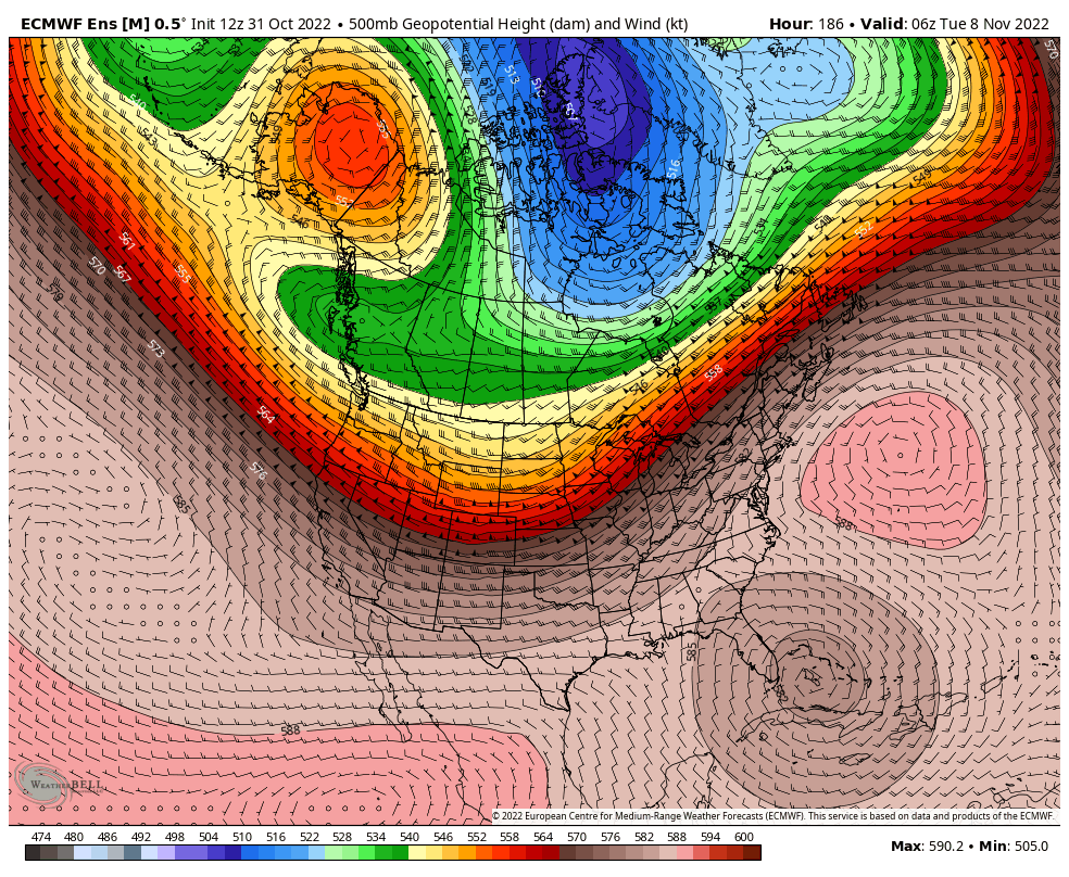
Haven't had a chance to put anything out regarding the upcoming period until now, but we are definitely seeing the most volatile weather pattern we have seen in many months coming up for the first half of November (And likely beyond), in part thanks to the MJO still rolling along and the PV on the move. The upcoming first 1/3rd of November, as everyone can see, will start off mild sub-forum wide. This is due to the continued -PNA, favoring Western US troughing through the period...Combined with little to no upstream blocking (+NAO). This pattern is fairly consistent with the progression of the MJO we have been seeing. This will lead to a fairly mild opening 8 days of the month across pretty much the entire sub-forum. Later in this opening 1/3rd of the month, things will trend cooler across northern portions of the sub-forum...Which is also when our members up in Duluth and Bo-land will see increasing chances for synoptic snows. This alteration of things will be due to larger scale changes, as the pattern will continue evolving with time as we eventually head into the middle 1/3rd of November. But more on that at a later time...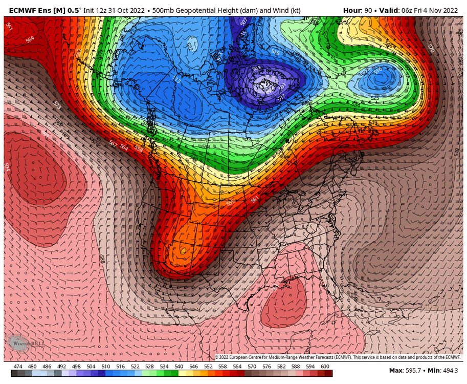

-
We have definitely entered the most active and wettest pattern we have been in since July. The next two weeks will have a parade of storm systems on the regular.