Chicago Storm
-
Posts
19,240 -
Joined
-
Last visited
Content Type
Profiles
Blogs
Forums
American Weather
Media Demo
Store
Gallery
Everything posted by Chicago Storm
-
I'd have waited another day or so on this one, due to the pattern. The 18z GFS is what you'd expect to get in this progressive pattern for much of our region...a glorified FROPA.
-

Winter 2023/24 Short Range Discussion
Chicago Storm replied to Chicago Storm's topic in Lakes/Ohio Valley
0.3" ORD, 0.1" MDW and 0.7" RFD with the snow overnight/this morning. -
Winter 2023/24 Short Range Discussion
Chicago Storm replied to Chicago Storm's topic in Lakes/Ohio Valley
A dusting to 1.5" of snow is still on tap area wide through the morning, with the disturbance/storm system moving through. -
For the stuff that isn't thread worthy...
-
Winter 2023/24 Medium/Long Range Discussion
Chicago Storm replied to Chicago Storm's topic in Lakes/Ohio Valley
I wouldn't get too caught up in the potential revolving around next weekend for several more days. We're shifting into a fairly progressive pattern, and there are several pieces that need to be well placed for things to work out. Guidance is a go for now...We'll see how things look come Wednesday/Thursday. -
Winter 2023/24 Medium/Long Range Discussion
Chicago Storm replied to Chicago Storm's topic in Lakes/Ohio Valley
Everything favors a progressive pattern, so I wouldn't expect to see that cutoff idea come back and see reality. -
that makes zero sense.
-
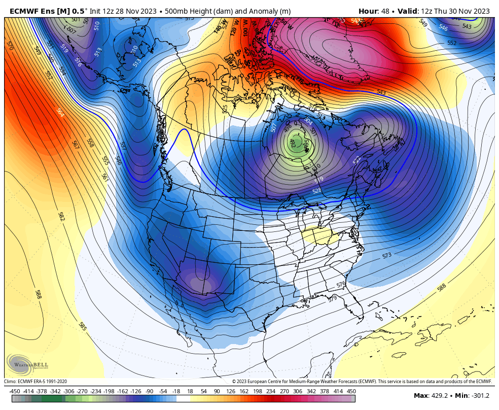
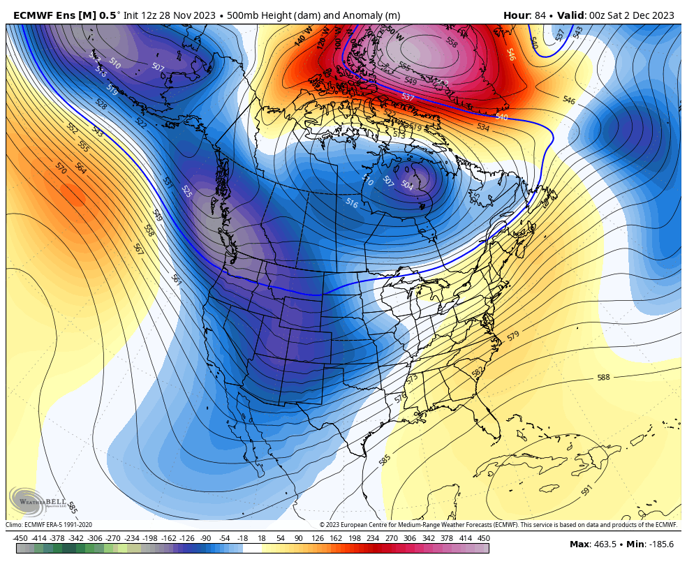
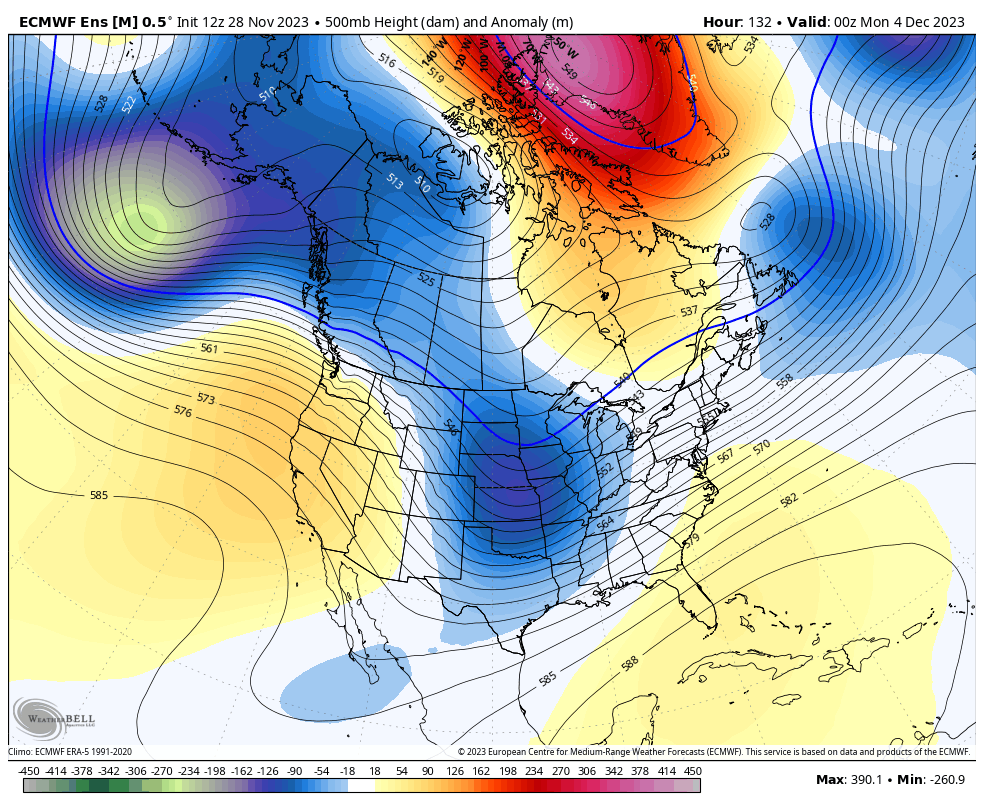
We'll be kicking off the calendar flip from November to December with a pattern that actually has some potential if you're looking for wintry weather. The main question is...Will it produce? We are quickly transitioning from one major pattern shift, which is bringing the current wintry period, to another major pattern shift. Similar to the current pattern, this next change will also be fairly short in duration, lasting only a week or so. This new pattern is very complex, blocky, and active all in one. We are seeing a fast-developing, potent -NAO ridge in the vicinity of Greenland, with a PV lobe trapped beneath it, anchored around the Hudson. Further west and south, we will be seeing a formidable -PNA develop for a time, with a fair bit of troughing in the west and also a slight flexing of the Southeast ridge. The -NAO/Hudson PV lobe combo will keep cold temperatures within reach and keep any potential activity from being too far northwest, while the Western troughing will provide numerous disturbances that will eject out across the country. On paper, this period has potential, but at the same time, it has the same amount of potential to feature strung-out/flat messes as well. In other words, keep a watch on things and don't rule out a surprise.


-
it snowed two days ago.
-
Fall 2023 Medium/Long Range Discussion
Chicago Storm replied to Chicago Storm's topic in Lakes/Ohio Valley
Haven't had much time to discuss it, but as hinted to in a response to a post from Josh post about two weeks ago, after Thanksgiving was a period to watch for wintry conditions...and that is indeed what we have seen unfold. This wintry period is a product of a potent -NAO and Alaskan ridge pairing, which dislodged a PV lobe, sending it south and anchoring around the Hudson. Albeit brief, this is a fairly significant pattern shift than has been seen this new season thus far. We have another significant pattern shift already in the process of unfolding. Will have more on that tomorrow...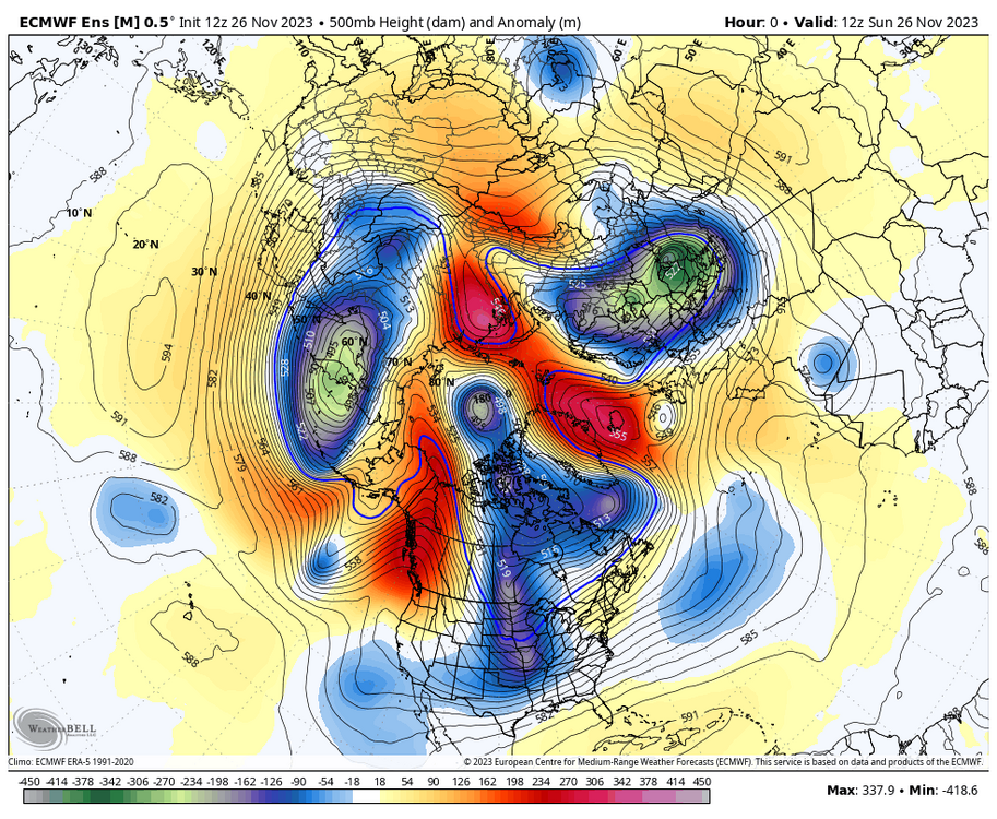
-
1.8" was indeed the final storm total at ORD. 0.8" at MDW and 1.5" at RFD.
-
Total of 1.8” at ORD as of noon, which will likely be the final storm total. Eyeballing ~1.5-2” here at home .
-
The first widespread event of the season is on tap for tonight and Sunday, across a decent chunk of the sub-forum. Guidance has trended towards slightly better phasing between the southern trough/wave coming out of the Plains and a northern trough/wave along the Canada/Northern Plains border. Looks like a widespread 1-3” event. .
-
Wednesday and Thursday featured top notch weather around here for a week before Thanksgiving, with both days featuring highs in the mid-60's and ample sun. We've reached the point where there's an abnormal amount of foliage still lingering, some of which is still green. Even with the cool down coming for a period of time after Thanksgiving, it's looking likely we'll be still carrying some foliage, some green, on into early December.
-
Fall 2023 Medium/Long Range Discussion
Chicago Storm replied to Chicago Storm's topic in Lakes/Ohio Valley
just a modest cool down, eh? and only for next week you say, huh? gonna start off the season with two L’s. hate to see it. -
I’m guessing it’s some sort of burn at one of the large preserves around there. There were so many burns going on at local preserves today that there was a layer of smoke during the afternoon. It was significant enough to put it in OBS here at ORD for a while.
-
3.6 magnitude earthquake near I-80 in North-Central Illinois earlier this morning. .
-
Noticed a few bees and mosquitos around here last week. .
-
Winter 2023-24 Longrange Discussion
Chicago Storm replied to michsnowfreak's topic in Lakes/Ohio Valley
That’s likely a bit too early, but after that quite possibly. -
Fall 2023 Medium/Long Range Discussion
Chicago Storm replied to Chicago Storm's topic in Lakes/Ohio Valley
Maybe down south at some point. Definitely not this upcoming week, though. -
Winter 2023-24 Longrange Discussion
Chicago Storm replied to michsnowfreak's topic in Lakes/Ohio Valley
Partially an example as to why it's not wise to take any given teleconnection at face value based off one of the plots. -
doin’ pretty good around these parts at least.
-
there is nothing great about that place, that’s for sure. .
-
Solid agreement on deep toughing returning to the West Coast much of next week, as we see a bit of a shake up in the large scale pattern across North America and vicinity. This will lead to another period of very mild temperatures across the sub-forum.
-
Halloween 2023 finished as the 5th coldest and 2nd snowiest Halloween on record for Chicago. Top 10 Coldest Halloween's: 1. 31 - 1873 2. 32 - 1917 3. 33 - 2019 4. 37 - 1878 5. 38 - 2023 6. 39 - 1930 6. 39 - 1906 6. 39 - 1874 9. 40 - 2017 9. 40 - 1996 9. 40 - 1954 Top 10 Snowiest Halloween's: 1. 3.4" - 2019 2. 0.9" - 2023 3. 0.1" - 2014 4. T - 1993 4. T - 1955 4. T - 1926 4. T - 1918 4. T - 1917