-
Posts
19,124 -
Joined
-
Last visited
Content Type
Profiles
Blogs
Forums
American Weather
Media Demo
Store
Gallery
Everything posted by Chicago Storm
-
Conditions slowly, but steadily increasing here in Cortez. Getting low end tropical storm force wind gusts, with a slow water rise over the past hour to hour and a half.
-
Currently in Cortez, FL…on the coast near Bradenton. The outer bands have been gusty, but nothing significant. Monitoring for the possibility of needing to step south a bit.
-
Starting the morning here in St. Pete, and will be stepping southward as needed through the day today.
-

Fall/Winter '24 Banter and Complaints Go Here
Chicago Storm replied to IWXwx's topic in Lakes/Ohio Valley
Flying into Orlando tomorrow morning to "chase" Milton. -
September 2024 finished tied as the 2nd warmest September on record for Chicago. Record Warmest September's 1. 71.2° - 1931 2. 70.6° - 2024 2. 70.6° - 1960 2. 70.6° - 1908 5. 70.3° - 2021 6. 70.2° - 1978 6. 70.2° - 1925 6. 70.2° - 1881 9. 70.1° - 1906 10. 70.0° - 1939 10. 70.0° - 1921
-

Chicago Weather Records Tracking
Chicago Storm replied to Chicago Storm's topic in Lakes/Ohio Valley
September 2024 finished tied as the 2nd warmest September on record for Chicago. Record Warmest September's 1. 71.2° - 1931 2. 70.6° - 2024 2. 70.6° - 1960 2. 70.6° - 1908 5. 70.3° - 2021 6. 70.2° - 1978 6. 70.2° - 1925 6. 70.2° - 1881 9. 70.1° - 1906 10. 70.0° - 1939 10. 70.0° - 1921 -
MDW does usually win the race against ORD, but there is some variability from year to year... 2024: +2 MDW 2023: +2 ORD 2022: +12 MDW 2021: +8 MDW 2020: +6 ORD 2019: +4 MDW 2018: +3 MDW 2017: Even 2016: +9 MDW 2015: +8 MDW 2014: +5 MDW 2013: +4 MDW 2012: +5 ORD 2011: +5 MDW 2010: +1 MDW
-
Things ended on a high note this weekend, with the last hot/summer-like day of the year... Topped out at 92° at ORD and at 93° MDW on Saturday. ...2024 90°+ Day Tally... 25 - MDW 23 - ORD 19 - ARR 19 - LOT 18 - RFD 18 - PWK 17 - DPA 10 - UGN
-
This late season stretch of summer continues... Topped out at 90° at MDW on Thursday. Peaked at 91° at ORD and at 92° MDW on today. ...2024 90°+ Day Tally... 24 - MDW 22 - ORD 18 - ARR 18 - LOT 17 - RFD 17 - PWK 16 - DPA 10 - UGN
-
I've noticed over time that those who make the drought monitor maps are usually slow at adding conditions and slow at removing conditions. Not sure why the lag on both ends, but it always seems to be the case.
-
With the help of the increasing drought, we've eeked out a few 90° days recently. Topped out at 90° at ORD on Sunday. Peaked at 90° at both ORD and at MDW on Monday. ...2024 90°+ Day Tally... 22 - MDW 21 - ORD 18 - LOT 17 - PWK 17 - ARR 16 - RFD 15 - DPA 10 - UGN
-
lol
-

2024 Short/Medium Range Severe Weather Discussion
Chicago Storm replied to Chicago Storm's topic in Lakes/Ohio Valley
Activity around here on Tuesday evening/night had prolific lightning production. It was probably a top 10 light show. Ended up with a peak wind gust of 53MPH at ORD, with some blowing dirt/dust for awhile as well, as it has been dry and outflow winds were well ahead of any rain/t'storm activity. -
A few record tied or broken during this recent period... ORD had a low temperature of 74° on August 25th, which tied the record high min temp for the date of 74° (1959). ORD had a low temperature of 79° on August 26th, which broke the record high min temp for the date of 77° (1973). ORD had a high temperature of 99° on August 27th, which broke the record high max temp for the date of 97° (1937).
- 231 replies
-
- 1
-

-
- absolute trainwreck?
- abandon all hope?
-
(and 1 more)
Tagged with:
-

Chicago Weather Records Tracking
Chicago Storm replied to Chicago Storm's topic in Lakes/Ohio Valley
Chicago/O'Hare had a low temperature of 74° on August 25th, which tied the record high minimum temperature for the date of 74° (1959). Chicago/O'Hare had a low temperature of 79° on August 26th, which broke the record high minimum temperature for the date of 77° (1973). Chicago/O'Hare had a high temperature of 99° on August 27th, which broke the record high maximum temperature for the date of 97° (1937). -
Topped out at 99° at both ORD and at MDW on Tuesday. ...2024 90°+ Day Tally... 21 - MDW 19 - ORD 17 - PWK 16 - RFD 16 - LOT 15 - DPA 15 - ARR 10 - UGN
- 231 replies
-
- absolute trainwreck?
- abandon all hope?
-
(and 1 more)
Tagged with:
-
lol. i didn't have a beavis summer rant in my card deck, but it lived up to the usual winter lol's.
- 231 replies
-
- 6
-

-
- absolute trainwreck?
- abandon all hope?
-
(and 1 more)
Tagged with:
-
it didn't.
- 231 replies
-
- absolute trainwreck?
- abandon all hope?
-
(and 1 more)
Tagged with:
-
you had said if it were to hit 100° today it would be historical, which other than breaking a daily record, it would not be. as you have said, it has it 100°+ in sept before, and on multiple occasions. take your nonsense elsewhere.
- 231 replies
-
- 2
-

-
- absolute trainwreck?
- abandon all hope?
-
(and 1 more)
Tagged with:
-
Catching up on what's ongoing... Topped out at 91° at ORD and at MDW on Saturday. Peaked at 93° at ORD and 92° at MDW on Sunday. Reached 96° at ORD and 95° at MDW today. ...2024 90°+ Day Tally... 20 - MDW 18 - ORD 16 - PWK 15 - RFD 15 - LOT 14 - DPA 14 - ARR 9 - UGN
- 231 replies
-
- absolute trainwreck?
- abandon all hope?
-
(and 1 more)
Tagged with:
-
tth. It hit 100° last year on 8/24. (Not that I think it will hit 100°+, because I don’t.)
- 231 replies
-
- absolute trainwreck?
- abandon all hope?
-
(and 1 more)
Tagged with:
-

Summer 2024 Medium/Long Range Discussion
Chicago Storm replied to Chicago Storm's topic in Lakes/Ohio Valley
what's coming up for next weekend-ish is going to be limited to a few days. so, there's still nothing consistent or long lasting upcoming. nonetheless, it's good to see another good push of summer conditions on tap. at this time of year, you never know when your last may be. -
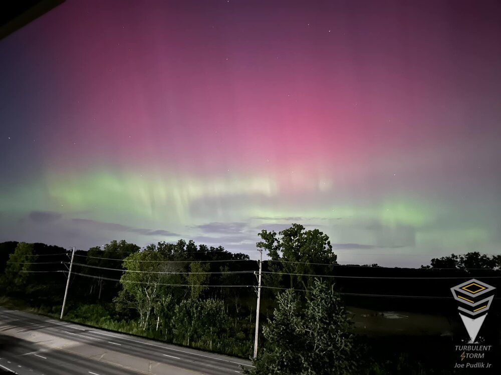
Northern lights/aurora displays were camera and eye visible in the metro area on Sunday night. Took this iPhone shot off of our balcony.
- 231 replies
-
- 15
-

-
- absolute trainwreck?
- abandon all hope?
-
(and 1 more)
Tagged with:
-

2024 Short/Medium Range Severe Weather Discussion
Chicago Storm replied to Chicago Storm's topic in Lakes/Ohio Valley
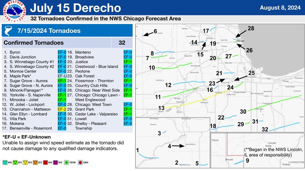
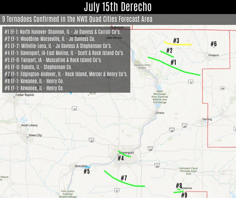
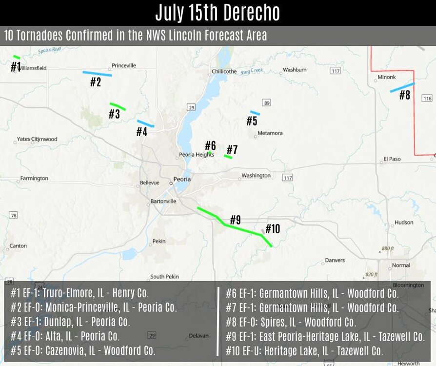
NWS offices have been putting the final touches on info regarding the July 15th derecho severe t'storm event in the area. In total, 48 tornadoes occurred with the July 15th derecho across N and C Illinois. This total sets a new state record for most tornadoes in a 24 hour period, in a single day, and for an event. In addition to the state records set, 32 tornadoes occurred across the LOT CWA in IL and IN. This total blew out the previous record of 22 tornadoes, set on June 30th, 2014, during a double derecho event. ...IL CWA Totals... DVN: 9 LOT: 30 ILX: 10 ................... Total: 48 (Note: One tor crossed from ILX to LOT, so the overall tor count is one less.) -

2024 Short/Medium Range Severe Weather Discussion
Chicago Storm replied to Chicago Storm's topic in Lakes/Ohio Valley
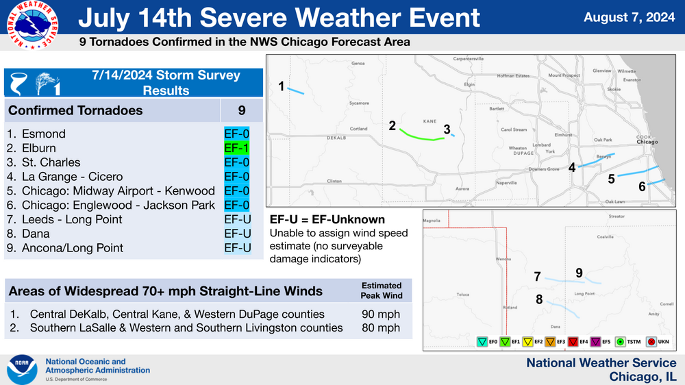
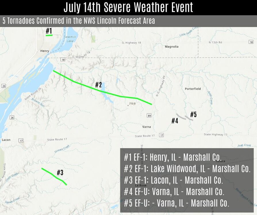
NWS offices have been putting the final touches on info regarding the July 14th and July 15th (Derecho) severe t'storm events in the area. For the severe t'storm event on July 14th, LOT and ILX have confirmed that 14 tornadoes occurred across their CWA's. (9 LOT & 5 ILX).


