

Chicago Storm
-
Posts
18,586 -
Joined
-
Last visited
Content Type
Profiles
Blogs
Forums
American Weather
Media Demo
Store
Gallery
Everything posted by Chicago Storm
-
Temps might overachieve today, with less cirrus than expected. Already around 60 as far north as MLI and PNT. .
-

Winter 2019-20 Medium/Long Range Discussion
Chicago Storm replied to Hoosier's topic in Lakes/Ohio Valley
zzzzz... Edit: Should mention that since my last post last week, the GEFS caved to the EPS in showing fairly close to the same as below.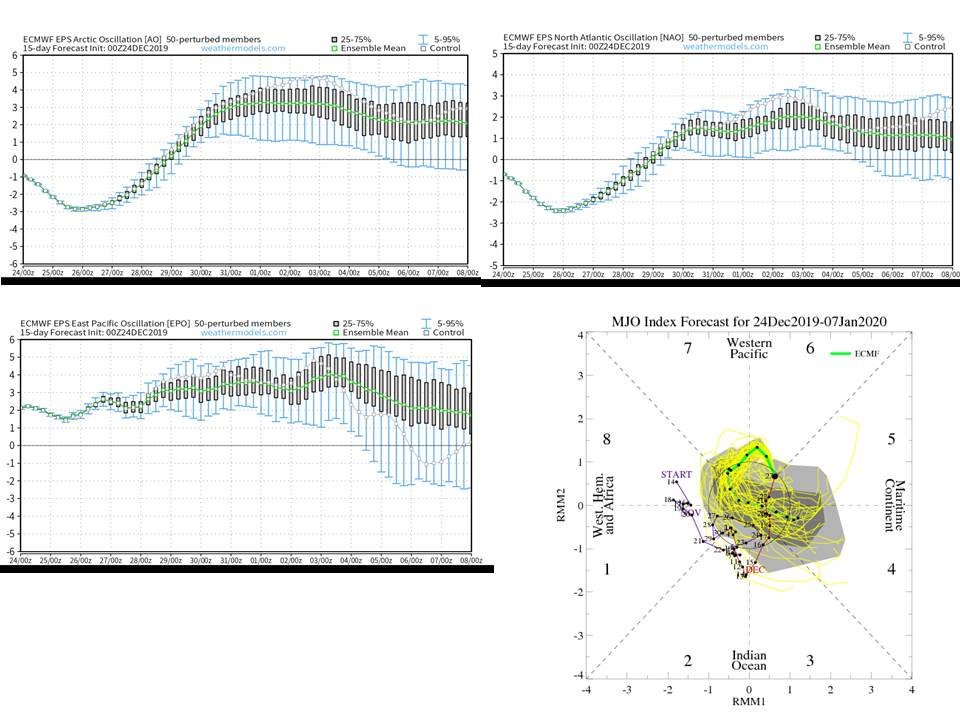
-
Winter 2019-20 Medium/Long Range Discussion
Chicago Storm replied to Hoosier's topic in Lakes/Ohio Valley
After that 1-2 run change, they reverted back. . -
Winter 2019-20 Medium/Long Range Discussion
Chicago Storm replied to Hoosier's topic in Lakes/Ohio Valley
As you could probably figure out by the current/upcoming pattern, the Euro ENS were correct in handling/depicting a +EPO...while the GFS ENS failed horribly. The bad news...If ENS have a good handle on things, that upcoming potential pattern change guidance was hinting at to end December and begin January might be in jeopardy. The Euro and GFS ENS are showing a continued +EPO continue right on into early January. On top of that, the Euro ENS also have a +AO/+NAO/neutral PNA set in as well. The GFS ENS are a bit more subdue overall, more similar to what we are seeing now. Also of note, is that some of the GFS and Euro ENS have the MJO moving from the COD on into phase 6 for the late Dec/early Jan time-frame. If that were to happen, combined with the potential teleconnections in projected, and the fact the main PV will be up over the North Pole/Siberia...things *could* get even more torchy/snow-less...and that's saying something given how the past 5 weeks have been. Not saying that will happen... But the projected teleconnections alone should be a concern that an overall mild/snow-less pattern continues into at least early January. -
Exactly what I was thinking. Definitely a positive step, but I could see how the northern zone will still be an issue at times.
-
The changes are finally coming...
-
Winter 2019-20 Medium/Long Range Discussion
Chicago Storm replied to Hoosier's topic in Lakes/Ohio Valley
The "people" have been wrong so far. So I wouldn't put too much stock into what they say. However on the flip side, it does appear there is support for the potential of a more favorable pattern for cold/snow around or after the New Year. The GFS ENS are more gung-ho on this than the Euro ENS though. -
Winter 2019-20 Medium/Long Range Discussion
Chicago Storm replied to Hoosier's topic in Lakes/Ohio Valley
Equal chances either way that far out. However, it is sort of interesting at the same time that there is not even a long range fantasy storm heading into January. -
Winter 2019-20 Medium/Long Range Discussion
Chicago Storm replied to Hoosier's topic in Lakes/Ohio Valley
A lot of valid questions/possibilities. -
Winter 2019-20 Medium/Long Range Discussion
Chicago Storm replied to Hoosier's topic in Lakes/Ohio Valley
You know it’s bad when the GFS doesn’t even have a fantasy snowstorm the entire run...which extends into the first days of January. Not just for our region, but the whole country pretty much. . -
0.3" at ORD and 0.2" here last night.
-
Winter 2019-20 Medium/Long Range Discussion
Chicago Storm replied to Hoosier's topic in Lakes/Ohio Valley
-
Winter 2019-20 Medium/Long Range Discussion
Chicago Storm replied to Hoosier's topic in Lakes/Ohio Valley
12z GFS was a nice torch for Christmas, and the days prior. -
So.....post more then? .
-
You mean the pre-Christmas warm up. .
-
It came north, with more of a slight SW-NE swath/track. It can only go so far north though, with the PV lobe swinging into the northern lakes from Canada. .
-
Huge changes again aloft. Now it’s trying to close off the main wave as it ejects out. That’s a new one...don’t think we’ve seen a model/run trying to do that, until now. .
-
NAM .
-
Very little by Saturday evening 0z's...Full by 12z Sunday.
-
Agree with this.
-
It's ova, outside of a DAB.
-
Other guidance is fairly similar. Without a more amped wave, or one that tries to close off, this is what we're going to have.
-
6z Euro is back south and weaker. .
-
DAB is actually my thought right now. .
-
If this one doesn’t work out, under 1” will be close to a lock. .


